Tuesday, March 7, 2017

I Seek Newton, Part VII: Thompsonville

From Dave Brigham:

Is there silver in them thar' hills? Or remnants of a Baptist mission on a street corner? Or even radical Italian political literature socked away in the woods?

I would wager that a significant portion of the residents of Newton, Mass., have never heard of Thompsonville. The smallest of the city's 13 villages, T'ville, as some call it, for many people functions as little more than a pass-through between the shopping centers of Route 9 in Chestnut Hill and the boutiques, restaurants, coffee shops and banks of Newton Centre.

But there's more, of course, some of it still standing or at least possible to find by poking around the bushes and woods. Other parts of the backside of T'ville exist only on old maps, and in memories and rumors, which make them more intriguing.

Welcome to the seventh part of my ongoing series about the backside of Newton, Mass., my adopted hometown. For links to the previous six parts, see the bottom of this post.

With each successive post about the villages of Newton, I dig deeper and take more photos. So although T'ville has a pretty small footprint, get ready for a long post with tons of pictures.

My wife and I lived in Thompsonville from late 1997 to the summer of 2000. We rented a small house on a dead-end street off the busy Langley Road, which connects Newton Centre to Route 9. Our Italian-American landlord, who had grown up in the house but lived elsewhere in Newton, called the place La Casita Flatita, which he translated as "the tall skinny house," although if you look it up in Italian or Spanish there's no such word as "flatita."

The house had just two bedrooms and one bathroom, unless you counted the disgusting, outhouse-level loo in the basement. The basement was also where our landlord's father had mashed his own grapes to make wine. There was ledge protruding into the basement, which his father had chipped away at, so as you walked from the bottom of the stairs toward the back of the basement, you had to gradually lower your head until you were barely stooping when you found the old wine barrels.

We liked living there; the street was quiet, there was a conservation area just steps away, and we could walk to Newton Centre for breakfast or dinner and drinks. When the landlord told us he was going to sell the house, we talked it over and made an offer. He rejected our offer, so we looked elsewhere and bought a house about 15 minutes away in Boston's West Roxbury neighborhood.

It took a while, but eventually a developer paid not much more than we had offered for La Casita Flatita. He leveled it, blew up the ledge that was impeding expansion and built a side-by-side duplex that squeezed onto the lot like a potbelly pig on a postage stamp. Not long after, another developer (or perhaps the same one) bought the house next to our old one, where an elderly shut-in lived, as well as the house beyond that. Now, where once stood houses with history and stories and quirks, there are generic townhouses assessed at between 2 1/2 and nearly 4 times the amount we offered our landlord for the cute little house with wine barrels in the basement and old grape vines hanging in the backyard.

(Townhouses massed along Carlisle Street, replacing the old, single-family homes that stood when I lived there in the late '90s.)

Even the witch's house has been rehabbed of late.

For years this place was run down, with peeling paint, a useless jalopy in the driveway, overgrown bushes and shrubs in front and along the sides. When my wife and I lived just around the corner all those years ago, we noticed over the course of a few days a dead crow and squirrel on the sidewalk in front of this house, where an old woman lived. We joked that she must be a witch, because of the deceased animals and the overall creepy vibe of the place.

(This old garage maintains its, shall we say, lived-in look while so much around it goes high-end. The house on this property dates to 1900; not sure about the garage.)

The tide really began to turn toward faceless, upscale housing with the 2003 construction of The Terraces, a 48-unit complex of townhouse-style condos built in the woods directly opposite the street I used to live on. Where there once was a nice wooded area, there now stands this:

Despite all of the high-end housing in Thompsonville, and the even higher-priced stock a short walk away in Newton Centre, Thompsonville still maintains somewhat of a backwoods vibe.

When I lived there, I took full advantage of walking 50 yards to the dead-end, scooching down the small incline where the pavement broke off, and descending into the little hidden valley of Cohen Conservation Area. Developers haven't changed this element of Carlisle Street...yet.

Walking down into the Cohen woods is Newton's equivalent of goin' down in the holler.

The conservation area is a small area (about 7.6 acres) that abuts the Webster Conservation area, the size of which may be threatened by the recent purchase by Boston College of a nearby synagogue and surrounding acreage. In the small pocket of the Cohen woods there are rock outcroppings, slivers of Thompsonville Brook, portions of ledge and your everyday hand-cut stones with trees growing through them.

(Culvert for Thompsonvlle Brook in Cohen Conservation Area.)

(There are quite a few pieces of hand-cut and polished stone that obviously have been sitting around Cohen Conservation Area for quite some time.)

All of this stuff is fascinating enough, but there's also a whiff of mystery here:

"In the woods near Thompsonville, a few hundred feet south from the road, and where a silver mine was reported to have been discovered in the autumn of 1877, the granite rocks are curiously split and cleft asunder; and beautiful quartz clusters and lumps of milky quartz are found. There are also deposits of mica, and very interesting specimens of carbonate of lime. The particles of silver are too minute to be of much value." -- from Samuel Smith's History of Newton, Massachusetts, which was published in 1880.

Funny how Smith goes from talking about a "silver mine" to indicating that the silver is more or less worthless.

The Cohen paths never veer far from the dead-end streets off busy Langley Road. But you feel as though you're in a hidden valley.

(Looking out from the conservation area toward Madoc Street. From the street, a path continues into the woods and connects with what appears to be the remnants of Carlisle Street, where I once lived. A 1929 maps of Newton shows the streets meeting up, with Carlisle continuing through the woods and joining with nearby Elgin Street -- see photo below. I'm not sure if those streets actually ran through the woods or if there were perhaps just plans to have them do so. Either way, there are power lines along the wide path.)

Also at the end of Carlisle Street there is a short, nicely wooded path connecting to Houghton Village, a community of low, moderate and market-rate rental units, something in short supply in Newton.

(A plaque at the entrance to Houghton Village memorializing Eloise Houghton, who was active in the Newton Community Development Foundation, which provides affordable housing in the city.)

(A path behind a Houghton Village unit leading into the conservation area.)

Walking out of Houghton Village toward Langley Road, the main artery running through Thompsonville, I saw numerous townhouses and duplexes, similar to the ones that replaced the house my wife and I once lived in.

I also saw lots being cleared in advance of new developments.

The bottom photo shows clearing at a site where at least two houses once stood. I haven't been able to determine what's going in here, but according to the Newton Assessors Database, the same trust owns the two lots in addition to an empty lot, so I imagine there will be several homes or townhouses going in here.

Directly behind that site is Bowen Upper Field, where you'll find soccer and baseball fields. This is also the general area where the original Bowen School stood (the school was knocked down many years ago; a newer school is located on the site of the old school's playground).

(Old staircase and stone wall leading from Langley Road to Bowen Upper Field, sitting where the old Bowen School once stood.)

The dead-end streets off Langley Road have some nice old-world features to balance out the new-world condos and townhouses. Through the trees in one yard on Beecher Place, I spied what I believe is a root cellar. Looks like it might still be in use.

If you were to walk through the back yards of Beecher Place, or follow some of the trails in the Cohen Conservation area, you'd end up in the back parking lot of the Mall at Chestnut Hill. Built in 1974, the mall stands approximately on the spot of the most unusual property owner listing on any old map of Newton I've seen: Gabriele d’Annunzio Club of Newton.

It's not unusual to find names of clubs, businesses and organization on the old Atlas maps of Newton, of course. Trustees of Newton Y.M.C.A., Boston Academy of the Sacred Heart, Albemarle Golf Club, etc. I'd never heard of Gabriele d'Annunzio, however, so I looked him up. According to Atlas Obscura, d'Annunzio "was a war hero and famous libertine, and he essentially invented Fascism as an art project because he felt representative democracy was bourgeois and lacked a romantic dramatic arc."

An Italian who was born in 1863 and died in 1938, d'Annunzio was a self-promoting, sex-obsessed poet and megalomaniac, according to the Atlas Obscura article. He served in many capacities during World War I, and, upset at the end of the war because, well, the war was over, marshaled a few hundred troops and took over the Austro-Hungarian city of Fiume. He installed himself as leader, or, as he saw it, Messiah. He ran the place as a cult of personality, and used "inflammatory speeches full of rhetorical questions from balconies flanked with pseudo-religious icons. He outfitted his troops in embellished black shirts and soft pantaloons, and told them to march through the streets in columns, palms raised in a straight-armed Roman salute that would be plagiarized by the Nazis," according to the Atlas Obscura article.

Read the whole article to get a better idea of how much Mussolini (and, to a lesser degree, Hitler) ripped off d'Annunzio, and to find out why he is still revered in his home town in Italy.

So why was there a club in Thompsonville named after a proto-Fascist? Now, I don't want to get in trouble here, but it seems at one point this little village was somewhat of an Italian enclave. There's not much in the way of a "downtown" T'ville, but two buildings that line the southern end of Langley Road, just before it hits Route 9, are the Italian Benevolent Society Filippo Corsi (founded in 1915) and Trutony's Deli, which specializes in Italian food.

(The Italian Benevolent Society Filippo Corsi.)

(Trutony's Deli, located in a building that dates from 1920.)

(A 1920-era building across from Trutony's.)

Property owner names from the 1929 Atlas include Pignatelli, Spezzano, Gasbarri (there was also a Gasbarri Ave. off Florence at the Boylston angle), Signori, Sostilio, Antonucci, Terzacca, Recchia, Caruso, Paulini, Fontecchio, Cipriano -- in addition to Irish and Anglo names aplenty.

I imagine the benevolent society at one point had ties to the d'Annunzio Club, which was incorporated in 1922, according to some documents I found online. Italian immigrants at the time were discriminated against, so invoking the name of a famous Italian war hero for the name of one's club has some logic to it.

(Remnants of a stone wall along Route 9, near the site of the old d'Annunzio Club, where now stands The Towers of Chestnut Hill condo complex.)

At the end of Langley Road, at the intersection of Jackson Street just before Route 9/Boylston Street, there once was a Baptist Church, according to an 1875 map of Newton I found at the city's web site. I came across a reference to a "Baptist Mission Chapel" on the Village 14 blog, which serves as an online town common for Newton. The blog posted a photo from the dedication of the Bowen School in 1952, which shows a scene from what evidently was a short play. The caption says, "Scene 1: 1878, Baptist Mission Chapel, corner of Langley Road and Jackson Street."

Currently on that location stands the benevolent society.

Along the part of Jackson Street that functions as an off-ramp for Route 9, I spied this battle of man vs. nature.

In the triangle formed by Route 9, Jackson Street and Langley Road stands a war memorial.

On the opposite corner once stood a favorite dinner destination for Newtonites: Tony's Italian Villa. Now the building houses a home theater installation company. A few steps east along Route 9, past the stone wall in front of The Towers, sits Moody Street, a quiet dead-end with some interesting dynamics at work.

(Old foundation -- house? barn? -- on the corner of Moody Street and Route 9 -- that's evidently been like this for a few decades. I'm not sure of the age, but it seems pretty old.)

(Close-up of the old foundation, which I stumbled across while out and about taking photos around Chestnut Hill and T'ville.)

While searching on the Newton Assessor's Database for information about the old foundation's lot, I found that many of the 15 houses and two vacant lots on Moody Street are owned by C & R Trust. A little more research led me to the names C&R Management, the company run by Julian Cohen and Daniel Rothenberg (C&R) that developed the Mall at Chestnut Hill.

Most of the houses on this short street were built between 1940 and 1950; one was built in 1966. After snapping pictures, I chatted with a person who lives on the street (whom I will keep anonymous) and learned that the rental homes "are not well-kept," and that the the trust "regularly asks homeowners (like my source) if they want to sell so that they can control the entire street." My source thinks there is a master plan to build more condos, like the nearby tower units, or an access road to the mall.

Across Route 9 sits this beautifully restored building.

Once a gas station, it is now the fitness area for the the Residences at Chestnut Hill, a large condo complex built in 2004. I was surprised as I walked around south of Route 9, in the area where Thompsonville meets Chestnut Hill, at the number of apartment and condo complexes. Side note: when my wife and I lived in T'ville, we bought our Christmas trees from two guys sitting next to the gas station, warming themselves over a garbage can fire.

Click here to see an old photo.

One of the developments in this area is The Farm, which features units ranging in size from 742-4,283 square feet, with some priced well over $1 million.

I don't know what sort of farm this complex replaced. I dig the old mill stone-type sign at the property's entrance.

Continuing on my merry way, I ended up on Louise Road, which is probably considered part of Chestnut Hill. The road is right on the border with Brookline. For some reason, a barrier was put up between the cities' respective parts of Craftsland Road.

Based solely on circumstantial evidence, I'm guessing this was a Brookline initiative, as the houses on that city's part of the road are much nicer than the ones on Newton's side.

Louise Road borders Brookline's Lost Pond Reservation, which connects to Kennard Park in Newton (see June 6, 2011, "Stonewalling," for my write-up on the park).

Louise Road also borders The Farm, the buildings of which you can see in the background of this photo.

I'm not sure if this was once a road connecting through to the property where The Farm now stands. Certainly looks like it.

Back out on Florence Road, which connects Route 9 eastbound and Hammond Pond Parkway (and which becomes Heath Street once you hit Brookline), I found something I've never come across before: perfectly preserved ghost stairs and a wall.

This area has undergone massive change in recent years. I remember driving past this site many years ago, after spending time at the nearby Atrium Mall (R.I.P.) and seeing a quaint old house. When the nearby Omni Foods grocery store and other old retail and office buildings were torn down to make way for the Chestnut Hill Square retail complex, I intended to take photos of the old house. But I was too late. I'm impressed that this element of the past was preserved.

For more on the redevelopment of this site, see "Chestnut Hill Phoenix" from June 11, 2010, and "UPDATE: Chestnut Hill Phoenix" from January 10, 2012.

My tour of Thompsonville (and a slice of Chestnut Hill that I missed in my write-up of that village) ends on a solemn note.

Chestnut Hill Memorial Park sits just behind the new shopping center. The park memorializes the five people who died in a massive fire in an office complex in February 2000. I'm happy that members of the community and, I'm guessing, the developers, got together to construct this peaceful retreat, which will surely look better in the spring and summer.

Here are links to the previous six installments:

December 5, 2016: Chestnut Hill (#6)

September 26, 2016: Oak Hill (#5)

June 3, 2016: Waban (#4)

March 23, 2016: Newton Highlands (#3)

September 20, 2015: Auburndale (#2)

May 21, 2015: Newton Lower Falls (#1)

I'm not sure what village will be next. I still have to cover West Newton, Newton Centre, Nonantum, Newton Upper Falls, Newton Corner and Newtonville. I'll most likely take on Nonantum, which is close to my house and not as large as some of the others. Stay tuned....

Wednesday, March 1, 2017

Anniversary Post #1: My Favorites from 2010

From Dave Brigham:

The photo above is the first one ever posted to this blog, back on March 1, 2010. I took that picture around the corner from my house, along a walking path on the Charles River. In the seven years since that introduction, this blog has published 422 posts from numerous authors/photographers, covering topics ranging from downed military planes (see Kristen Smith's "Lost Bomber" from March 14, 2011) to abandoned towns (see Mick Melvin's "Dearly Departed Dearfield," from July 9, 2010), hidden roads (see my "End of the Road" from January 24, 2011) to the long-vacant Naval Air Station South Weymouth (see Derek Watt's "Hangar Stake" from January 20, 2016), and so many things in between. Just search through the keywords running down the right side of the blog to get an idea of the breadth of this project.

By my count, we have posted at least one item about 36 individual states in the good ole US of A. I have tried over the life of the blog to enlist contributors from different regions of the country, in order to live up to the expansive title I gave this site. The bulk of the hundreds of posts here, however, cover five of the six New England states (we haven't shouted out to Rhode Island...yet), and, more specifically, the portion of eastern Massachusetts near where I live.

This is the first in a series looking back at some of my favorite posts we've run on the blog. This installment covers March - December 2010. Additional installments will look back at highlights of each of the years from 2011 - 2016. There will be other non-series posts in between these installments. Somewhere in this series I will get serious and discuss some of the challenges of running this site, as well as exciting changes coming to The Backside of America.

Before I get to my best-loved posts from 2010, I need to mention a very important omission. Joe Viger has contributed some amazing photos and fantastic write-ups over the years, but I'll be linking to very few of them in this series. Why? Because Joe -- an amazing photographer who has served as a mentor of sorts to me in that regard, and a great friend I've known for nearly 30 years -- has changed the security settings on his Flickr account so that many of his photos that have run on this blog show up as broken links now. I will instead direct you to his wonderful online portfolio.

From May 6, 2010, "Of Bradless and Muhammad Ali," in which Mick Melvin explores a symbol of how the Internet has had a negative impact on the brick-and-mortar retail world: an abandoned shopping center in Manchester, Connecticut. The shopping center was torn down a few years ago.

Also, some cool graphic art.

On June 8, 2010, David Burke wrote about the long-abandoned train station in Torrington, Connecticut, in "Meet Me At the Station (We'll Find a Way In)." I rarely explore inside abandoned buildings, and found myself jealous of David's ability to do so with this old building. He got some cool photos of the odd assortment of artifacts within. The station was torn down in 2011.

This is why we document the things we do. So many old buildings go into neglect and get torn down. People forget them.

"Bank Shots," posted by David Burke on June 14, 2010, features wonderful photos of the Terryville Bank & Trust building in Terryville, Connecticut, as well as a nice personal essay.

A local auto dealer acquired the neglected and dilapidated building in late 2015 and indicated that despite its initial hope to save the structure, the building was beyond help. I've been unable to find out whether the building has been torn down.

On July 25, 2010, I wrote about a spooky old place in Watertown, Massachusetts, that I'd dubbed the Scooby-Doo House, in "This Old, Decrepit House." I love the photo I took showing the layers of the old place peeled away. The house was torn down a month after I posted; condos were put up in its place.

Also in July 2010 I posted about and took photos of the Tin Man Diner in North Falmouth, Massachusetts, in "Two Hearts Beat as One." This is one of those rare times when I spoke with someone directly about the history of a place I profiled, instead of just doing research online. Unfortunately, the Tin Man Diner is no longer in business.

David Hill took his sailboat over to Peddocks Island in Boston Harbor one day, and wrote about it and shared some terrific photos on August 27, 2010, in "Shuttered Island." The island was used as a setting in Martin Scorsese's "Shutter Island" movie. The island is still open to the public.

The King is dead....I wish I could say "Long live the King," but the wall in Newton, Massachusetts, that once featured Elvis Presley's face was torn down. On October 16, 2010, in "Faded Glory," I posted some photos of that beautiful mural and others located in and around a playground in Nonantum section of Newton, known locally as The Lake.

The blog has featured very few human faces over the years. I hoped there would be some folks bowling the day I stopped by the Guido Salvucci Bocce Court in Boston's Brighton neighborhood.

Still, my November 18, 2010, post, "Guido's Court," gives the reader an appreciation of the old-world charm of the place. I believe the court is still active.

So that wraps up my nine favorite posts (out of 78) from the first 10 months of the blog. Stay tuned for more regular posts, as well as more installments about the future of The Backside of America and reviews of the years 2011-2016. And, as always, if you or someone you know would like to contribute, send me an email (dbrigham_us@yahoo.com) or a message on our Facebook page.

Friday, February 24, 2017

Backside Hunting in Boston

From Dave Brigham:

As longtime readers of this blog are aware, my son, Owen, and I take a lot of trips on Boston's Green Line trolleys (see August 30, 2010, "Going Underground," July 18, 2013, "Cool Stones" and June 27, 2016, "Bridge Project Afoot?").

Any time we're above ground, I look out the windows of the trolleys for cool features of the city. I spied a few along Huntington Avenue in the Mission Hill and Fenway neighborhoods, and recently returned on foot to shoot a few pictures.

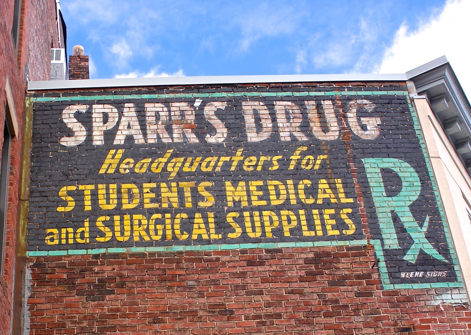
The Sparr's sign catches my eye every time we ride by on the Green Line's E branch. Situated in the Longwood medical area, the store appeared to me to be open, but after some online research I think it's closed. Owned by the nearby Harvard School of Public Health, the building hosts community art exhibits, but for decades Sparr's was the go-to place for medical and surgical supplies, as well as daily necessities and a meal at the lunch counter. Read more about the store at this link.

To see a photo of what the store looked like in earlier days, check this out.

In addition to hospitals and medical labs, Huntington Avenue is home to numerous colleges and universities. Mixed in with the numerous newer dorms are older buildings that look humble now but perhaps once had grand ambitions.

I love named buildings like these. Unlike apartment buildings and corporate offices of today, with boring typefaces and focus group-approved company names, these old places had their monikers chiseled right into their often ornate facades. For more named building-related posts, see Parts I, II, III and IV of my Named Building Series.

I couldn't find any information about the origin of the names of the Ormonde and Elsie buildings.

Finally, a small milestone marker hiding in plain sight.

This is one of many such markers between Springfield, Mass., and Boston, according to this Boston Globe article about a Massachusetts Department of Transportation effort to restore the milestones.

The markers indicate the distance from certain points, to the city of Boston. This one reads "Boston 4 Miles 1729 PD." In addition to Boston, markers are located in towns and cities including Brookline, Cambridge, Leicester, Shrewsbury and Warren.

Friday, February 17, 2017

Stone Cold Surprise

From Dave Brigham:

Folks unfamiliar with New England's history and geography might wonder, as they walk through conservation areas like Stony Brook (depicted in the photo above) on the Weston/Lincoln border in Massachusetts, "Why are there so many stone walls in the middle of the woods?"

Because farming. You can't swing a walking stick in New England, it seems, without hitting a stone wall. Testaments to the Herculean effort that Colonial farmers put into mastering the earth in order to farm it, the walls were once used as property boundaries and for animal control. Now they are beautiful reminders of the history -- the sweat, toil and misery of digging up the stones and first tossing them into a pile and then stacking them in an orderly fashion -- of our rocky region. For more on these monuments to hard work, check out this Earth Magazine blog post.

I've taken plenty of photos of stone walls in the course of exploring for this blog. I don't ignore them and don't get bored by them. That would be like walking through an art gallery and refusing to look at the walls. Still, I always hope for something more when I go on excursions into the woods around Massachusetts.

Stony Brook is a place I've passed countless times in the past year and a half, as it is located about halfway between my home and the school in Sudbury where I drive my son Monday through Friday. I had been out Route 117 before my son started going to this school, and have a vague memory that there was a small building in the parking lot for the conservation area.

This suspicion was confirmed by, what else, a Google search. From the Bay Circuit Alliance web site: "Parking at riding ring at north end of Browning Field North on Weston Rd, along shoulder of Weston Rd (but not on gravel rd off Weston), and at the ice cream stand on Rte 117 at Weston/Lincoln line."

I sent an email to a member of the Weston Historical Commission, who in turn forwarded my question about the old building to "Weston’s best source for the town’s history parcel by parcel." From this woman, Pam Fox, I learned that there was a building roughly in this spot. She said a longtime resident who owned farmland along Route 117 told her that the building was known as Johnny's Fudge Stand. She sent a photo that she'd taken several years ago of the building, which looks a bit different from what I recall, but I have to imagine it's the same place.

Anyway....I recently ventured in after ignoring this little slice of woods for too long.

I walked out on this rustic little bridge at Twin Pond and saw a lot of birds. Then I bopped along the main trail, which never wanders far from residential areas in the tony towns of Weston and Lincoln. I often like to go out and back on the same trail, if possible, as I've realized that my eye catches different things from these two angles. And sure enough, somehow I'd missed this amazing cellar hole on my walk out.

This is one of the best-preserved, most solid-looking cellar holes I've seen in my travels. I've been unable to uncover any history online about this area. I plan in the future to venture to another area close by known as Pigeon Hill/Browning Field, as there are ruins of an old stone house. Stay tuned....

In addition to the wonderful cellar hole, this hike presented me with something I've never seen before.

When I posted this photo on Facebook there was a dispute as to whether this is a bat box or a house for wood ducks or screech owls. The evidence I was presented leads me to believe this is a bat box. If you know different, I'd like to hear from you.

Thursday, February 9, 2017

Round & Round

From Dave Brigham:

I would love to get inside this place. Built in 1856 by inventor and manufacturer Enoch Robinson, the Round House in Somerville, Mass., is a wonderful oddity shoe-horned into a tight neighborhood in the most densely packed city in New England. It has 14 rooms, is 40 feet in diameter and is on Preservation MASS's list of Endangered Historic Resources, according to this Wikipedia article.

I forget where I first heard or read about this place, but I finally checked it out last week. I was initially somewhat underwhelmed, as I had expected a larger lot, although I doubt any such thing exists in Somerville. I wanted the house to stick out like a beautiful sore thumb, with spotlights shining and signs pointing.

The house sits, somehow, almost unassumingly behind a chain link fence, surrounded on all sides by more typical homes. As I walked around it, trying to get the best angle for a photo, I began to realize how cool the house is. There are numerous great details around the windows and roof lines. I'm not sure what the metal box-like features are on the lower roof.

Located on Spring Hill, not too far from where I lived back in the mid-'90s, the Round House has been under renovation for quite some time. The house evidently had been abandoned for quite some time, according to Wikipedia, before its 2007 purchase by a man who owns a general contracting firm.

Per this 2006 online thread about the house, the owner "intends to restore every significant architectural detail of the house, both inside and outside, over time, and when it is prudent he will move his own family into it, returning the unique structure to its original use as a single-family home." This seems to indicate the house had been broken up into apartments as some point.

For more information about the Round House, including one photo of the interior, and some diagrams and photos showing how rough it looked before the renovation, check out this Centers & Squares realty web site. Also see the photos and research that the late, lamented Creepy-chusetts, Strange-chusetts blog did in 2010.

Wednesday, February 1, 2017

Bon Voyage, Lady

From Dave Brigham:

My first job when I moved to Boston in the fall of 1990 was at the World Trade Center. Through an agency, I worked as a temp for Fidelity Investments, a financial services company that has only gotten bigger in the intervening quarter century. In 1991, the area of South Boston where the WTC was located was a wasteland of parking lots (which were referred to as the mud flats), vacant lots, old wharf buildings and scattered old-time restaurants (Anthony's Pier 4 [R.I.P.], Jimmy's Harborside [R.I.P.]) and odd theme bars (Polly Esta's, R.I.P.).

Now known as the Seaport Hotel & World Trade Center, the building where I worked sits in an area absolutely unidentifiable from the urban desert it was as recently as 10 years ago. The building that heralded the massive changes that have taken place was the John Joseph Moakley United States Courhouse, named for the late, long-serving U.S. Representative from South Boston. Built in 1999, the courthouse sits right on Boston Harbor and mixes classic brick with a very cool glass wall that looks out on the harbor.

Since that building was erected, countless other gleaming glass office buildings, hotels, condo developments, restaurants and bars have followed. I shouldn't be surprised at the scale of change in this area of Boston. While on a break one day from my temp job at the WTC in the early '90s, I walked past a glass-walled conference room with a scale model of the district on a table. From end to end the table was filled with skyscrapers. I didn't think too much about it then, but have come to realize in recent years that change of this sort doesn't just happen. People put a lot of time, money and effort into these projects, in order to, of course, make money and put their stamps on Boston, but also to keep the city fresh and economically competitive.

Over the years of driving through this area, to events at the WTC, concerts at the pavilion on the waterfront, to eat at the Barking Crab or go to the nearby Boston Children's Museum, I noticed a small church.

The crane in the background of that shot tells the story. As massive developments have risen, the land the Chapel of Our Lady of Good Voyage sits on became more and more valuable. The chapel was built in 1952 "specifically to meet the needs of longshoremen and their wives who come to pray for the safe voyage and return of their husbands," according to an article at NorthEndWaterfront.com, which also features some photos.

While there are numerous stories around the U.S. and other countries of building owners holding fast against mega-developments, in this case, the Archdiocese of Boston came to an agreement in which it would sell the property and receive a new chapel just up the street (for our own take on holdout buildings, see January 25, 2014, "Last Building Standing").

(A close-up of the chapel, with a faceless corporate behemoth rising next door. This site will soon be home to a 22-story office building.)

(I hope they'll bring this statue along to the new site. If not, I'm sure they'll find a new home for the Virgin Mary.)

I have a few mantras about blogging for this site: "Get out your car and walk around," is the primary one. The other one is, "I don't have ulterior motives, except when it comes to the Backside of America." So when my son asked a while back about going on one of our semi-regular subway rides in Boston, I said, "Sure, but we're going to take a detour." So we hopped on the Silver line, which is a bus line that goes underground briefly between South Station and the World Trade Center.

Things have changed so much in the Seaport in the years since I worked there that I got turned around for several minutes, walking up and down Seaport Boulevard before I realized I needed to get to Northern Avenue. My son quickly pulled out his phone and directed us to our destination, which turned out to be very close to where we'd come up from the bus tunnel.

I knew I had to at least poke my head inside the chapel, but I didn't want to interrupt a service or disrupt anybody praying there. I'm glad I popped in.

It was a few months before I got back to take pictures of the new chapel under construction. I hoped the building would retain some of the old charm of the one that will soon fall under the wrecking ball.

I don't think it does. Do you? The chapel isn't complete, so perhaps the builders will add some flair or detail to evoke the old place.

(A nicely shaped church window is glassed in and forced to look out at a mega-building next door.)

Meandering in Milford

From Dave Brigham: In April, I ventured to the Grafton Flea Market , searching for vintage wooden boxes I could use to showcase prints of ...