Showing posts with label hiking. Show all posts

Saturday, March 29, 2025

Holy Moses! Look at These Old Tablets

From Dave Brigham:

Unlike Moses, I didn't need to ascend an Egyptian mountain to find amazing hand-carved tablets. Rather, my Mount Sinai moment came at the foot of a former trash heap in the leafy outskirts of Boston.

Somewhere, somehow (I really need to keep track of this stuff), I learned while minding my own business on the World Wide Internet about two large carved-stone blocks located along the Charles River in West Roxbury's Millennium Park. In a flash, I was gobbling up information at this blog post at And This Is Good Old Boston.

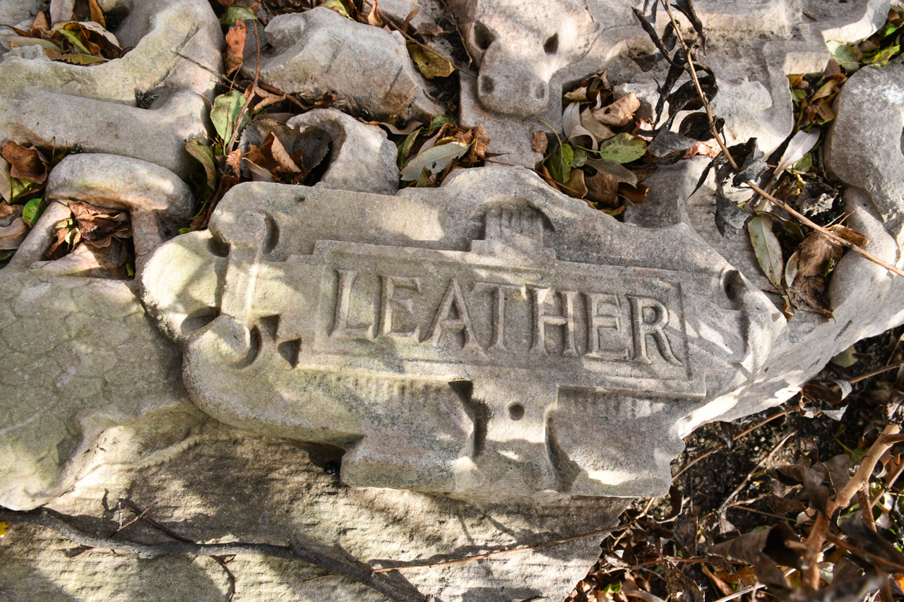
"The first is labeled 'Machinery' above the word are two machine gears, and to the sides are two classical figures swinging hammers," I read at the blog. "In the middle of the stone is a large shield, with a smaller American stars and stripes shield above it. On a ribbon running behind the American shield are the words E. Pluribus Unum....The second block is labeled Leather. Again, there is an elaborate shield in the center of the carving. This time, the smaller shield at the top represents the shield of the Commonwealth of Massachusetts."

Within relatively short order, I drove due south through several Newton villages and into West Roxbury. I parked in Millennium's kayak launch lot and followed the path at the western end, as instructed in the blog post. There were lots of families and couples walking dogs and generally enjoying a cool yet still warmer-than-normal autumn day.

I'd hiked a bit at the park a few times over the years, but I was still surprised at the steep angle of the former dump. At the top of the landfill cap are a handful of athletic fields, walking trails and a parking lot. But my quarry was located at the bottom of the hill, near the Charles River.

Sciatica pain be damned, I hobbled down the paved path, took a wrong turn, doubled back, and found a dirt path that seemed promising. I thought perhaps I was on the wrong trail, but when it turned left along the Charles River, I began to get a good feeling. And sure enough, about 30 feet past the lookout area where some folks had stopped to observe the river's drought-stricken water level, I found what I was looking for.

Despite knowing I would find them here, still I was fascinated (and dumbfounded) by these slabs. Measuring perhaps 5 feet by 3 feet, they are heavy and ostentatious and nearly otherworldly laying there just a few feet from where people hike every day. I sense your puzzlement. "What the hell are those things, and what are they doing there?"

"The seals were part of the 'First National Bank of Boston' façade," according to an anonymous commenter on the above-linked blog post. "I found some photos/ artist renderings along with a news article describing the building as having 5 of these carved 'plaques' in recognition of Bostons (sic) significant contribution to the textile industry."

While a subsequent commenter doubted whether that bank was the origin of the panels, further research by a Boston Globe reporter and the Boston City Archeologist confirmed that theory. "We pored over image archives and were able to find that the Boston Public Library had an image of the bank from 1910," the Globe article reports. "The tablets are just visible on the right side of the image, enough to confirm that the leftmost tablet is the 'Leather' tablet and the far right tablet is 'Machinery.'"

To see video of the tablets, check out this separate Globe article (I apologize if it's behind a paywall).

As I made photos, several people walked by. Since I was just a few feet off the trail, I assumed that to these folks, the discarded stone slabs were old news. I'm so happy I stumbled across mention of this bizarre treasure, because I never would have found myself walking along this part of the park, and if by some miracle I had, I likely wouldn't have noticed the large stone blocks.

While the detectives mentioned in this post were able to determine where the tablets came from, no one has definitively been able to say how they ended up in their current position. The First National Bank of Boston was demolished in 1944. "In the mid-20th century, the hill [now known as Millennium Park] was first used as a gravel quarry, resulting in a massive hole in its center," according to the Globe article featuring the city archeologist. "That hole became a convenient place to dump trash, so the city turned it into the Gardner Street Landfill, a municipal dump that was used into the 1980s. As the First National Bank was demolished during a time when the landfill was active, it’s likely that these and other fragments of the bank were dumped unceremoniously in West Roxbury."

These big chunks are pretty far from the old landfill site, located very close to the river. It's likely somebody dragged the stones there. But how long ago? And why?

For a post about another slab of stone sitting in a puzzling site, check out "I Seek Newton, Part III: Highlands", a March 23, 2016, post about the Newton Highlands neighborhood and Cold Spring Park.

Saturday, November 23, 2024

Jalopies in the Landlocked Forest

From Dave Brigham:

I really need to keep better track of where I get leads for this blog. At some point in the last several months, I read about a place called the Landlocked Forest in Burlington, Mass. I can tell you that I saw somebody's photos on Flickr featuring junked cars in the wooded expanse, and that's what convinced me to visit.

The conservation area is located on the border with neighboring Lexington. I parked in the small lot along Turning Mill Road, not far from an old paint mine I explored several years before (see September 2, 2014, "Make Mine Paint").

Along the power line trail leading to the forest, I met a distressed ursas arctos.

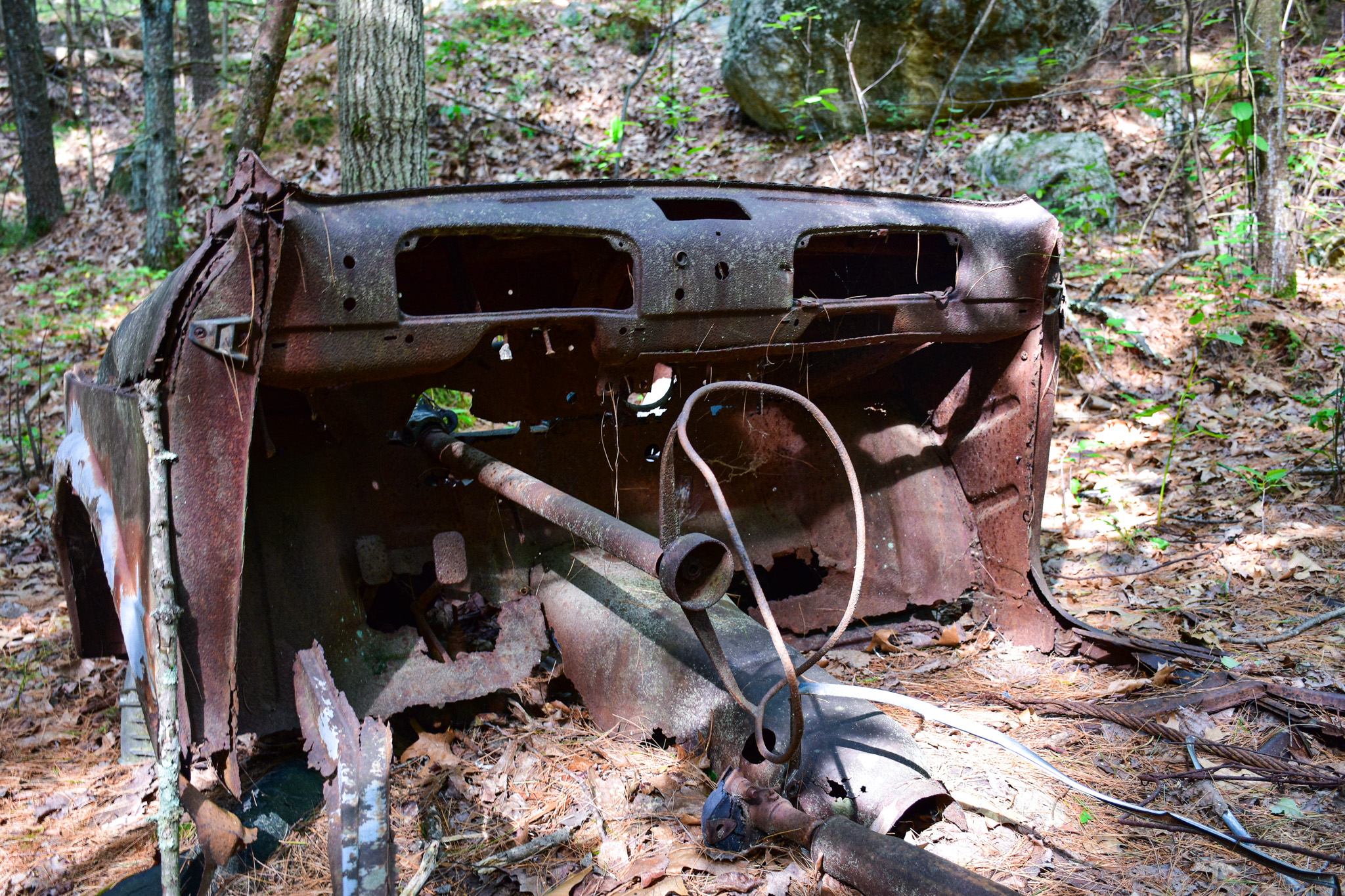
Once I got in the forest, I spent approximately 98% of my time and 87% of my energy swatting away bugs of all sorts - mosquitos, flies, gnats, you name it. I had a general idea of where the rusted-out jalopies were, so I followed my instincts as I headed north through the trees. After a while, I came across some extremely rusty something-or-others.

While the Friends of the Burlington Landlocked Forest indicates on its web site that there is within the woods a stone foundation from a home dating to the 1700s, I didn't see it. And I have no idea what the rusted metal in the photos above might have been. Part of an old shed, perhaps?

I kept chugging along, heading east until I was close to Route 3. I'd seen a mama deer, thanks to a heads-up from a passing mountain biker, but not much else of interest. I turned back to the west, swatting away bugs all the while, trying to make sense of Google Maps as I wandered. I got close to a residential development at one point, so had to head a little more south. I hit a few dead ends and was starting to get a little frustrated when -- AHA!!

I don't know what kind of car that is, nor can I identify either of the other two show below.

So why are there cars strewn across the wooded landscape in the middle of a lovely hiking and biking oasis?

Until the 1950s, at least some of the forested land was privately owned. There was, I assume, at least one road here, a throughway where at some point a few cars broke down or were stolen and abandoned. In the '50s, the state extended Route 3 south through Burlington and "owners of the property within the Landlocked Forest were compensated by the State because they were now unable to access their land," according to the Friends of the Burlington Landlocked Forest web site.

In the ensuing decades, the property owners petitioned the state legislature to permit access to the land from Route 3, but each time they were denied. In the late 1980s, the Town of Burlington took the property by eminent domain and created the conservation area.

I hope to return to the Landlocked Forest this fall or winter, when I can enjoy an insect-free walk.

To see more junked cars in the woods, check out the links below:

March 30, 2024, "Finding the Fascinating Ford's Folly"

August 30, 2016, "The Tavern of Death"

April 2, 2010, "Time Capsule Car"

Saturday, June 29, 2024

Skirting a Superfund Site to See Some Ruins

From Dave Brigham:

Located in a "four corners" area where Acton, Sudbury and Maynard meet with the southwest corner of Concord, Powder Mill Woods Conservation Area is a peaceful little oasis with an explosive past.

Nestled between residential developments, the Thoreau Club (about which more below) and a Superfund site (also about which more below), Powder Mill Woods is the latest tucked-away area of intrigue I've explored in Concord (see April 20, 2024, "More Military Relics in the Home of the American Revolution" and December 4, 2012, "Concord, Part I: Old Rifle Range").

"The area has a 100-year history of gunpowder manufacture, the depressions in the landscape ideal for protecting individual buildings," according to the Town of Concord's Powder Mill Woods Trail Guide. "Trails follow 19th-century cart paths and narrow gauge railroad beds once used to move materials among separate buildings of the production process."

I knew from looking at the trail guide ahead of time that I'd stumble across the twisted rails shown below, but I still was pleasantly surprised.

"These narrow-gauge rails are relics of a railroad used by the American Powder Mills and other gunpowder manufacturing companies that once operated here," according to a sign posted next to this display of gnarled metal. "Horse-drawn rail-mounted carriages hauled materials on the railroad from as early as 1880 until at least 1913."

There are other small remnants spread throughout the woods.

As I strolled along, I was aware of fences and "No Trespassing" signs along the northern perimeter. That's because between the conservation area and Main Street, there is the Nuclear Metals, Inc., site. "The Nuclear Metals, Inc. site – also known as the Starmet Corporation site – is located on a 46-acre parcel in Concord, Massachusetts," according to this U.S. Environmental Protection Agency web site. "Nuclear Metals made depleted uranium products, primarily for armor-piercing ammunition. It also manufactured metal powders for medical applications, photocopiers, and specialty metal products such as beryllium tubing used in the aerospace industry. From 1958 to 1985, waste was discharged into an unlined holding basin. Facility operations contaminated soil and groundwater with hazardous chemicals. Following immediate actions to protect human health and the environment, the site’s long-term cleanup is ongoing."

I'm not sure what will become of the site once it has been cleaned up entirely.

I knew from the trail guide that there were ruins in the area, so I kept tromping until I found them.

Gunpowder production began on this site in 1835. "At its peak, production involved forty buildings scattered throughout the 400-acre area in Acton, Concord, Maynard, and Sudbury," according to the trail guide. "The mills produced 1,000 lbs. (450 kg) of gunpowder per day during the American Civil War."

"Ruins of these buildings and the roads between them can still be found in the land along Forest Ridge Road, both sides of Route 62, and in the Thoreau Club property. Remnants of a large concrete building can be seen beside the old roadbed that passes through the northeast corner of the Thoreau Club land."

Those concrete ruins are what I photographed here.

Nearby I checked out some cabins associated with the Thoreau Club's summer camp.

The club was founded in 1951 by Clifford and Dorothy Pulis. The camp "was the fulfillment of a dream to create a day camp where they could share their love of nature, the outdoors and their camping expertise," per the club's web site. "Incorporating their own wilderness camping experiences and a quote from Henry David Thoreau’s Walden, 'Every morning an opportunity to make life of equal simplicity with nature,' the...Pulis team created a unique camp environment that captured the feeling of the deep woods of Maine in rural Concord, MA."

Saturday, June 1, 2024

Doing Time on the Reformatory Branch Trail

From Boxcar Willie:

Like a 19th-century murderer sent up the river to Concord for a long hitch, I've had the Reformatory Branch Railroad on my mind for quite some time.

OK, that's a terrible opening sentence, something worthy of the Bulwer-Lytton Fiction Contest, which challenges participants "to write an atrocious opening sentence to the worst novel never written." Still, my point stands: since my buddy Chris DeBarge, owner/operator of Bird in Hand Tattoo and a fellow explorer, mentioned the old railroad line in Bedford and Concord, Mass., many years ago, I've wanted to get there. And boy am I glad I did - I loved the trail and the history and the reformatory and found so much more than I'd expected.

Let's hop this freight!

I'm going to start not where I started, nor my point of completion, but rather somewhere in the middle.

The sun was setting on the former Billerica and Bedford Railroad Engine House as I wrapped up my hike along the old right-of-way for the Reformatory Branch, which I will get to shortly. I had no idea that this nicely restored building, the adjacent Boston and Maine Railroad engine and the Middlesex Central Railroad Passenger Depot were located in the heart of Bedford.

This area marks the northern terminus of the 10.1-mile Minuteman Bikeway, which also runs through Lexington, Arlington and Cambridge. The trail was built by the Commonwealth of Massachusetts on an inactive railway bed in the early 1990s. The old freight/engine house, which dates to 1877, now serves as an information center, museum and gift shop.

The train set on tracks right outside the engine house door is "Rail Diesel Car #6211, which was one of 110 purchased by the Boston & Maine Railroad from the Budd Company to be used for commuter and branch line service," per MACRIS. It is available to rent for meetings or special events.

As for the depot, it was restored in 2014, five years after the freight house was given the same treatment. Both buildings had been under private owneship for decades prior. The Stick Style building dates to 1874. I believe there are small businesses located here. The old depot has some great details.

OK, now let's get to where I started my adventure, at the eastern end of the Reformatory Branch Trail, which is located just south of the John Glenn Middle School, a short distance up Railroad Avenue from the old depot complex.

"The Reformatory Branch Trail was originally a railroad right of way of the Middlesex Central Railroad which opened in 1873 running from Lexington to Bedford and Concord," according to the Town of Concord's Reformatory Branch Trail Guide. "In 1879, the railroad was extended 2.5 miles west to Elm Street near the Concord Reformatory (now the Massachusetts Correctional Institution facility), with a connection to other rail lines at Concord Junction in West Concord. The railroad was taken over by the Boston and Maine Railroad in 1887. Passenger service was maintained by the B & M Railroad until 1926 and remaining freight service until 1962 when the entire branch was abandoned."

I saw some nice trail-side details on this portion of my hike.

(Old fire hydrant.)

(Old concrete signal posts.)

(Kinda spooky, kinda heavenly.)

The trail was pretty muddy at certain points, which was no surprise, given the wet winter we had.

I briefly considered a detour into the Mary Putnam Webber Wildlife Preserve, but I had limited daylight and wanted to get as far down the trail as I could.

I was pleasantly surprised to see a view through the trees open up to the Great Meadows National Wildlife Refuge.

The refuge is accessible by car via a road that crosses the trail.

I ventured on a little longer, eventually turning around at Great Meadows Road once I'd crossed into Concord. I wanted to get back to my car before dark. I hiked for nearly two hours in boots that aren't great for my bad feet. But I was happy. Little did I know that after my trek, I'd stumble across Depot Park and two beautifully restored buildings and train car that I wrote about at the top of this post.

I resolved to complete as much of the Concord portion of the trail as I could, and so not long after my initial adventure, I did just that. I started where the trail hits Lowell Road near The Concord Market, and worked my way east toward Great Meadows Road.

A short distance in, I spied this old hunk o' junk in the woods just off the trail.

A friend tells me this is a rotary sifter of some type, perhaps for sifting gravel from sand for making concrete aggregate.

I also saw another signal post, this one a victim of edaphoecotropism.

I took a side trip to Sleepy Hollow Cemetery. But again, I didn't want to tarry, as I was on a mission and needed to double back in order to complete it. Below are some shots of the side trails I took to and from the graveyard, which is where some of Concord's most eminent folks are buried.

Since the bridge that once carried the Reformatory-bound trains over the Sudbury River was washed out by the 1938 hurricane, I returned to my car behind the market, and made my way toward Egg Rock.

To access Egg Rock, which is where the Assabet and Sudbury rivers come together to form the Concord River, I had to park on Nashawtuc Road and walk down Squaw Sachem Trail (a private road) and take the narrow path between two houses (#50 and #80).

And that opened up to -- tada! -- the Reformatory Branch Trail.

I headed east toward the confluence until I could go no further. Below is a photo showing where the bridge used to be.

I turned back west, figuring the trail might be blocked or overgrown as it ran along the Assabet, behind some very nice houses. But I was wrong! So I trudged forward.

My original plan was to return to my car, drive to MCI Concord, where the Reformatory Branch once led, make a few photos and try, probably half-heartedly, to find the trail. But since the trail kept going, so did I. Eventually the trail curved south and I ended up on a quiet road near a relatively new housing development. I didn't feel like bushwacking at the curve point to see if the trail continued, so I headed out toward Elm Street.

At this point, once again, the sun was heading toward the horizon, and my dogs were barking. But I'd come all this way, walked way more than I'd anticipated, and was determined to make it to the prison.

On the west bank of the Assabet River, hard by Route 2, I spied what I guessed might be a remnant of the railroad right-of-way.

And just past that, I made a photo of a house along Route 2 that may at one point have been affiliated with the prison, which is located across the road.

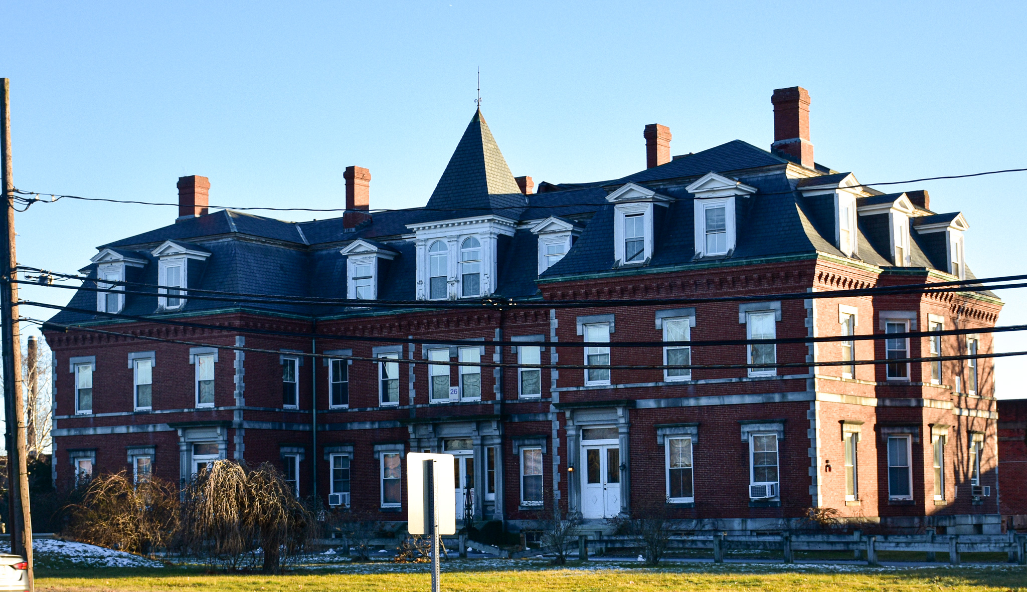
And then, at last, I found myself standing in front of the Second Empire building that I'd driven past countless times over the last few decades, the place that looks like a Victorian mental hospital.

Known alternately as the Massachusetts State Prison Warden's House and the Concord Reformatory Warden's House, this brick building at the Concord Rotary was once a residence and offices for prison personnel. MACRIS has an interesting take: "By far the grandest building in West Concord, the Superintendents' House uses the power of the French-inspired Second Empire style to assert its authority over both the prison behind it and the area around it."

It was built in 1878 as the main entrance to what was then a new prison. Over the years, older buildings were torn down and new, less architectually significant ones went up. Once the prison opened, development in West Concord increased dramatically.

From MACRIS: "From the mid-1880's on, much of the building boom, and the social and organizational structure of West Concord as well, was guided by the residents of this building, both before and during their tenures as Reformatory Superintendent and Deputy-Superintendent. Most influential was Joseph Scott, who, with George Russell, developed the Riverside Park neighborhood northeast of the reformatory while Superintendent in the early 1890's. In 1896, with Loring Fowler, he formed the two major Concord Junction real estate syndicates of the later 1890's — the Concord Junction Land Co. and the West End Land Co."

With the announcement earlier this year that the state plans to close MCI Concord -- as the prison has been known for quite some time now -- this summer, this area of Concord is slated for more big changes. The prison has been operating at less than half capacity for some time.

There is no definite plan for the site yet, but the possibilities are tantalizing. "The potential for the prison site situated on the dreaded Route 2 Rotary is enormous," per the Boston Globe article linked above. "For starters it should spur discussion of a reconfiguration of one of the state’s most fearsome traffic circles. But beyond that, 'It’s perfect for housing,' state Senator Mike Barrett, whose district includes Concord, told the Globe editorial board. 'It’s walkable to West Concord [center]' and its train station. 'It could be a whole new neighborhood.'"

I imagine a mix of housing, retail and office space will spring up here eventually. And I certainly hope that the old warden's house will be saved and restored and turned into something useful for the community.

New Balance Draws a Red Line with Diner

From Dave Brigham: I can't be expected to know everything about the backside of America, nor of Massachusetts or even of Boston. But I...