Showing posts with label train depot. Show all posts

Saturday, November 30, 2024

Pioneering in Leominster

From Dave Brigham:

Let's get this out of the way, for any non-New England readers: the Massachusetts town I am briefly profiling in this post is pronounced "Le-mu-nster," not "Leo-minster." And for those across the pond, feel free to stick with your "Lem-stuh" pronunciation, since the settlers borrowed the name from the English town in Herefordshire (don't ask me how to pronounce that...).

One other piece of business before I get to the good stuff: I made only a quick visit to Leominster, and plan to return to cover more of Worcester County's second-largest city.

Known as the Pioneer Plastics City, Leominster is the birthplace of the pink flamingo lawn ornament. I learned about this a few decades ago when I worked as a proofreader at an accounting firm, where one of the clients was a guy named Don Featherstone, the artist who created the whimsical decoration while working for Union Products.

I was happy to see that crosswalks in downtown Leominster feature pink flamingos at each end.

I skirt the northeastern part of Leominster on my way to and from New Hampshire to play music with friends a few times a year. Located about 20 miles due north of Worcester, Leominster was at one time filled with manufacturers of all sorts, making paper, pianos, combs, sunglasses and Tupperware products.

This post focuses on the city's downtown. I will seek out the industrial zones somewhere down the line.

My first stop was the old brick building housing Brady's, a restaurant, bar and event facility on Mechanic Street.

MACRIS has nothing on this place, but the Brady's web site indicates that the nicely restored building "has served as a furniture factory, hardware store and even Leominster’s Post Office in the early-1900s!" I can't make out the ghost signs in either of these photos.

Right around the corner on Water Street is a somewhat odd-looking diner (for reasons explained below) that's 75 years old.

Tim's Diner was manufactured in 1949 by Silk City Diners, a division of the Paterson Wagon Company of Paterson, New Jersey. According to the Roadside Architecture blog, this is the diner's original location, although it was originally known as Roy's.

"In 1953, Tim Kamataris Sr. purchased the diner from [the original owner] and rechristened the business 'Tim’s Diner'," according to this Diner Hotline Weblog post. In the early 1980s, there were two accidents in a short span of time that damaged the diner. "The original factory-built entryway was destroyed along with the stainless steel facade under the front windows being damaged beyond repair," per the article. "Tim Kamataris Sr. made the decision to replace the entryway and facade under all the windows along the front and right side of the diner with brick. Ironically, a second car accident hit the front wall again within a fairly short time after the damage was repaired from the first accident, this time to the right of the new entryway."

Long story, short: after many years of featuring a brick facade, the owner (now Tim Jr.) was able to use grants from the City of Leominster to restore the diner to "a reasonable facsimile to the way it originally looked."

Along Water Street, I shot the backside of Tilton & Cook Marketplace, which calls itself "the largest indoor new and used good marketplace in Massachusetts."

I haven't found anything online about the building. I like the old alarm rusting down the wall.

At this point, I doubled back and headed north to check out an amazing old train depot on Merriam Avenue.

Built in 1878 by the Fitchburg and Worcester Railroad, the Gothic Revival stunner features a 75-foot central tower and loads of wonderful details.

The old depot is currently home to Russell's Liquors.

Along Main Street, I saw the Christian Life Center and thought, "That used to be something else - probably a theater."

"Opened January 8, 1923, the Rialto Theater was one of at least three classic movie theaters in this Massachusetts city," according to Cinema Treasures. "Although the exterior clearly suggests this building’s former use as a movie theater, the interior seems to have been gutted and put to other uses. It now serves as the home of the Christian Life Center. The entranceway reveals what was part of the original entrance/lobby area, and ceiling details remain intact."

The architects of the theater were Funk & Wilcox, according to this post at the Boschen blog, which offers "Quick fun random stuff regarding classic movie theaters, Drive-in Theaters, film history, and related projects" that the author does. "Funk and Wilcox designed many buildings throughout Massachusetts including several theaters such as the Ware Theatre in Beverly and the Strand and Franklin Park Theaters in the Dorchester neighborhood of Boston," per the blog post.

The Rialto closed in the 1950s.

I headed southwest on Main Street, and while I saw many great buildings, the light and shadows were difficult, so I only shot two of them. The first is the Foster Building, which was built in 1874.

The second is the Wood Block, which dates to 1890.

I continued on to Union Street, where I saw a nice for a place that's unfortunately out of business.

I don't know when the Farmers Exchange opened or closed for business. Around the corner on Central Street is a much newer sign for an exchange of a different sort.

Bitcoin Ben's is an outlet of a company that I believe is based in Sarasota, Florida. "One of the goals of Bitcoin Ben’s Crypto Club is showing and utilizing the decentralized shareable economy experience," per the web site. "We want to increase awareness of cryptocurrency, blockchain and related technology."

I don't normally take signs of places like that, but I was intrigued by the juxtaposition of the old Farmers Exchange sign, indicative of a fading economy, with the bitcoin joint, which may be the future of commerce.

Here's hoping I can get back to Leominster soon!

Saturday, June 1, 2024

Doing Time on the Reformatory Branch Trail

From Boxcar Willie:

Like a 19th-century murderer sent up the river to Concord for a long hitch, I've had the Reformatory Branch Railroad on my mind for quite some time.

OK, that's a terrible opening sentence, something worthy of the Bulwer-Lytton Fiction Contest, which challenges participants "to write an atrocious opening sentence to the worst novel never written." Still, my point stands: since my buddy Chris DeBarge, owner/operator of Bird in Hand Tattoo and a fellow explorer, mentioned the old railroad line in Bedford and Concord, Mass., many years ago, I've wanted to get there. And boy am I glad I did - I loved the trail and the history and the reformatory and found so much more than I'd expected.

Let's hop this freight!

I'm going to start not where I started, nor my point of completion, but rather somewhere in the middle.

The sun was setting on the former Billerica and Bedford Railroad Engine House as I wrapped up my hike along the old right-of-way for the Reformatory Branch, which I will get to shortly. I had no idea that this nicely restored building, the adjacent Boston and Maine Railroad engine and the Middlesex Central Railroad Passenger Depot were located in the heart of Bedford.

This area marks the northern terminus of the 10.1-mile Minuteman Bikeway, which also runs through Lexington, Arlington and Cambridge. The trail was built by the Commonwealth of Massachusetts on an inactive railway bed in the early 1990s. The old freight/engine house, which dates to 1877, now serves as an information center, museum and gift shop.

The train set on tracks right outside the engine house door is "Rail Diesel Car #6211, which was one of 110 purchased by the Boston & Maine Railroad from the Budd Company to be used for commuter and branch line service," per MACRIS. It is available to rent for meetings or special events.

As for the depot, it was restored in 2014, five years after the freight house was given the same treatment. Both buildings had been under private owneship for decades prior. The Stick Style building dates to 1874. I believe there are small businesses located here. The old depot has some great details.

OK, now let's get to where I started my adventure, at the eastern end of the Reformatory Branch Trail, which is located just south of the John Glenn Middle School, a short distance up Railroad Avenue from the old depot complex.

"The Reformatory Branch Trail was originally a railroad right of way of the Middlesex Central Railroad which opened in 1873 running from Lexington to Bedford and Concord," according to the Town of Concord's Reformatory Branch Trail Guide. "In 1879, the railroad was extended 2.5 miles west to Elm Street near the Concord Reformatory (now the Massachusetts Correctional Institution facility), with a connection to other rail lines at Concord Junction in West Concord. The railroad was taken over by the Boston and Maine Railroad in 1887. Passenger service was maintained by the B & M Railroad until 1926 and remaining freight service until 1962 when the entire branch was abandoned."

I saw some nice trail-side details on this portion of my hike.

(Old fire hydrant.)

(Old concrete signal posts.)

(Kinda spooky, kinda heavenly.)

The trail was pretty muddy at certain points, which was no surprise, given the wet winter we had.

I briefly considered a detour into the Mary Putnam Webber Wildlife Preserve, but I had limited daylight and wanted to get as far down the trail as I could.

I was pleasantly surprised to see a view through the trees open up to the Great Meadows National Wildlife Refuge.

The refuge is accessible by car via a road that crosses the trail.

I ventured on a little longer, eventually turning around at Great Meadows Road once I'd crossed into Concord. I wanted to get back to my car before dark. I hiked for nearly two hours in boots that aren't great for my bad feet. But I was happy. Little did I know that after my trek, I'd stumble across Depot Park and two beautifully restored buildings and train car that I wrote about at the top of this post.

I resolved to complete as much of the Concord portion of the trail as I could, and so not long after my initial adventure, I did just that. I started where the trail hits Lowell Road near The Concord Market, and worked my way east toward Great Meadows Road.

A short distance in, I spied this old hunk o' junk in the woods just off the trail.

A friend tells me this is a rotary sifter of some type, perhaps for sifting gravel from sand for making concrete aggregate.

I also saw another signal post, this one a victim of edaphoecotropism.

I took a side trip to Sleepy Hollow Cemetery. But again, I didn't want to tarry, as I was on a mission and needed to double back in order to complete it. Below are some shots of the side trails I took to and from the graveyard, which is where some of Concord's most eminent folks are buried.

Since the bridge that once carried the Reformatory-bound trains over the Sudbury River was washed out by the 1938 hurricane, I returned to my car behind the market, and made my way toward Egg Rock.

To access Egg Rock, which is where the Assabet and Sudbury rivers come together to form the Concord River, I had to park on Nashawtuc Road and walk down Squaw Sachem Trail (a private road) and take the narrow path between two houses (#50 and #80).

And that opened up to -- tada! -- the Reformatory Branch Trail.

I headed east toward the confluence until I could go no further. Below is a photo showing where the bridge used to be.

I turned back west, figuring the trail might be blocked or overgrown as it ran along the Assabet, behind some very nice houses. But I was wrong! So I trudged forward.

My original plan was to return to my car, drive to MCI Concord, where the Reformatory Branch once led, make a few photos and try, probably half-heartedly, to find the trail. But since the trail kept going, so did I. Eventually the trail curved south and I ended up on a quiet road near a relatively new housing development. I didn't feel like bushwacking at the curve point to see if the trail continued, so I headed out toward Elm Street.

At this point, once again, the sun was heading toward the horizon, and my dogs were barking. But I'd come all this way, walked way more than I'd anticipated, and was determined to make it to the prison.

On the west bank of the Assabet River, hard by Route 2, I spied what I guessed might be a remnant of the railroad right-of-way.

And just past that, I made a photo of a house along Route 2 that may at one point have been affiliated with the prison, which is located across the road.

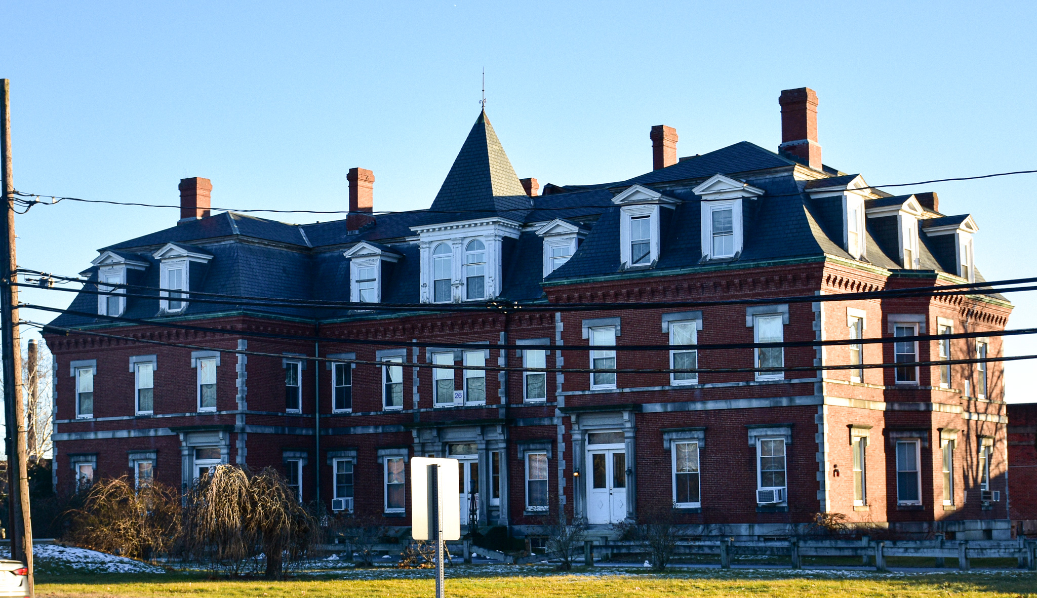
And then, at last, I found myself standing in front of the Second Empire building that I'd driven past countless times over the last few decades, the place that looks like a Victorian mental hospital.

Known alternately as the Massachusetts State Prison Warden's House and the Concord Reformatory Warden's House, this brick building at the Concord Rotary was once a residence and offices for prison personnel. MACRIS has an interesting take: "By far the grandest building in West Concord, the Superintendents' House uses the power of the French-inspired Second Empire style to assert its authority over both the prison behind it and the area around it."

It was built in 1878 as the main entrance to what was then a new prison. Over the years, older buildings were torn down and new, less architectually significant ones went up. Once the prison opened, development in West Concord increased dramatically.

From MACRIS: "From the mid-1880's on, much of the building boom, and the social and organizational structure of West Concord as well, was guided by the residents of this building, both before and during their tenures as Reformatory Superintendent and Deputy-Superintendent. Most influential was Joseph Scott, who, with George Russell, developed the Riverside Park neighborhood northeast of the reformatory while Superintendent in the early 1890's. In 1896, with Loring Fowler, he formed the two major Concord Junction real estate syndicates of the later 1890's — the Concord Junction Land Co. and the West End Land Co."

With the announcement earlier this year that the state plans to close MCI Concord -- as the prison has been known for quite some time now -- this summer, this area of Concord is slated for more big changes. The prison has been operating at less than half capacity for some time.

There is no definite plan for the site yet, but the possibilities are tantalizing. "The potential for the prison site situated on the dreaded Route 2 Rotary is enormous," per the Boston Globe article linked above. "For starters it should spur discussion of a reconfiguration of one of the state’s most fearsome traffic circles. But beyond that, 'It’s perfect for housing,' state Senator Mike Barrett, whose district includes Concord, told the Globe editorial board. 'It’s walkable to West Concord [center]' and its train station. 'It could be a whole new neighborhood.'"

I imagine a mix of housing, retail and office space will spring up here eventually. And I certainly hope that the old warden's house will be saved and restored and turned into something useful for the community.

Friday, July 16, 2021

Steps Away from An Eyesore, a Quaint Town Common

From Dave Brigham:

I recently spent a little bit of time in Troy, NH, something I'd wanted to do for a while. I pass through that town a few times a year on my way to play music with friends in the Granite State, and stumbled across an old mill complex a while back. That place, the abandoned Troy Mills, proved to be a fantastic photo opportunity (see June 21, 2021, "Covering a New Hampshire Blanket Mill"). Unfortunately for the people of Troy, it has been an eyesore for nearly 20 years.

After checking out the mill, I strolled through the quaint area around the town common. Here's what I found in Troy, which was incorporated in 1815, made up of parts of the towns of Marlborough, Fitzwilliam, Swanzey and Richmond.

Troy's town hall stands at the head of the common, which is an island in the middle of the bisected Route 12. Completed in 1815, this quintessential New England building was originally a meetinghouse, as I'm sure you guessed, where religious services and town meetings were held, according to this excellent Living Places article.

During those early years, both a local branch of the Congregational Church, as well as the First Congregational Society of Troy, used the meetinghouse. I'm not sure when the building became town hall.

I love the contrast of the red-brick house with the bright-white town hall. According to the Living Places article linked above, the house, at 12 Central Square, is known as a side-hall home. It was built by Stephen Wheeler, who operated a store and staging business. In later years, James Stanley, the cemetery sexton, ran a barbershop and later an undertakers' shop behind this house.

In the background of the photo above you can see an old barn. Below are close-ups of the one you can see, as well as a second one behind it.

Those buildings were built by Troy Mills for storage in 1901.

In the middle of the aforementioned common is a lovely little bandstand.

The bandstand is a newer addition to the common, although there was one located here previously. There was once a Troy Brass Band, which likely played at the old bandstand.

Just off the southern end of the common, behind Troy Deli & Marketplace and the Thai Bamboo restaurant, sits the wonderful Kimball Hall.

Originally home to the Odd Fellows fraternal club when it was built in 1901, Kimball Hall is currently home to the Troy Historical Society. I'm guessing that in the heyday of the mill, this place was jumping with dances, weddings, social club meetings and other events. From the historical society's Facebook page: "Folks who would like to tour the Cheshire Railroad Depot may stop at Kimball Hall to request it be opened."

I love that. Speaking of the depot....

Located just steps away from Kimball Hall, the station is known officially as the Troy Cheshire R.R. Depot. This fantastically restored place dates to 1847. During the latter half of the 19th century and well into the 20th, the station was kept busy by deliveries for Troy Mills and a nearby quarry, as well as by visitors to Mount Monadnock, located a few miles away in neighboring Jaffrey.

Passenger service along the rail line ended in 1958, freight service in the late 1960s, according to the web site above. Eventually the station was converted to a private home; the abandoned rail bed was maintained by the New Hampshire Department of Transportation for recreational purposes, and is now part of the Cheshire Recreational Rail Trail.

In 1998, the Town of Troy acquired the station and in 2002, restoration began. Check this photo gallery of the restoration.

Across the former rail bed from the station is an old barn/storage building that I'm guessing was once part of the railroad.

Folks visiting Troy via train might've stayed at the Kimball Hotel and Residence, below, which was built in the 1870s.

The former hotel is Troy's only example of a mansard-roof structure, according to this walking tour document.

I'm going to wrap up with a few shots from the Village Cemetery (formerly known as the Old Cemetery), which dates to 1785.

(I've never seen a gravestone age to this color.)

New Balance Draws a Red Line with Diner

From Dave Brigham: I can't be expected to know everything about the backside of America, nor of Massachusetts or even of Boston. But I...