From Dave Brigham:
As you might expect by its name, Newton Centre (British spelling, please) is the commercial hub of Newton, Mass. The village is home to an MBTA Green line trolley stop; the fire department headquarters; a burgeoning independent high school on a historic hilltop; restaurants, bars and retailers of all sorts; as well as churches, synagogues, cool older apartment buildings and backside elements aplenty.
Welcome to the 10th installment of my series about my adopted hometown. I started running this series in May 2015, and never thought that nearly six years later I'd still be working on it. For links to all of the previous installments covering the nine villages I've explored so far, see the bottom of this post. There are 13 villages in total; after publishing three posts about Newton Centre, I will cover Newton Corner, West Newton and Newtonville.
In this post, I'll cover cemeteries, churches (past and present) and synagogues, various municipal buildings, schools, public facilities and more.
I'm gonna start off from somewhere out in murky waters.

This pond is located in the Newton Cemetery & Arboretum, which dates to 1855 and sits behind the main library, between Walnut and Beacon Streets, and Commonwealth Avenue. There are a few other ponds in the massive cemetery, so I'm not sure if this is the one described in Samuel Francis Smith’s History of Newton, Massachusetts as being created via dam to serve a mill for grinding drugs and making chemicals. I'm not sure of the date involved here - it was either in the 17th or 18th century. After that mill, which was built by Dr. Samuel Clarke, burned and Dr. Clarke died, the land was sold to Rufus Brackett for a Morocco factory, per Smith's book.
"What the devil is a Morocco factory?" you might ask. I'd never heard of such a thing before researching this post. It's a building, in this case likely a small wooden one, where tanners use goat skin (mostly) to fashion pliable leather used for gloves, the uppers of shoes, bookbindings, wallets and other products, per Wikipedia.
One thing that continues to fascinate me as I roam around Greater Boston's woods, and conduct research online, is the sheer number of small-scale factories and mills that once dotted the landscape. It's easy to see and learn about the bigger ones dating from the Industrial Revolution forward, but the ones that were operated by a single person or small team, in areas that are now heavily wooded or that have been built over or turned into cemeteries, those just get my imagination racing.
I'll offer just one example: in February 2020, I posted about a long-overgrown site in Weston, Mass., where once stood a small factory that made machinery for the manufacture of heavy woolen goods, as well as successive mills that produced clocks, chairs and window and door screens (see February 19, 2020, "Bucking Around the Sears Land"). Nowadays, Weston is a haven for mansions, nicely wooded conservation areas and expensive European SUV's. You'd never know it was once a hub of small industry (OK, one more link: June 23, 2017, "Walking Through Weston's History," in which I discuss, in part, the former Hook & Hastings organ factory that once stood along Route 117 in this bedroom community).
Anyway, the cemetery in Newton Centre is beautiful, and contains a plethora of wonderful gravestones, obelisks and statues, as well as gardens and a beautiful chapel and other buildings. Below is a crypt for the Bray family, which includes Mellen Bray, who built Bray's Block in the heart of Newton Centre's busy retail area, which I will get to in a future post.

Below is an impressive marker for the Jackson family. I'm not sure whether this is the family that claims the first permanent European settler of Newton (see November 15, 2020, "I Seek Newton, Part IX: Nonantum (Section 3)", or perhaps a close relative.

Below is Bigelow chapel, which dates to 1885.


Even the cemetery administration building, which was built in 1915, looks pretty good.

And I love this bridge.

Let's move on to churches and synagogues.
Built in what's called the Italian Villa style, Sacred Heart Parish on Centre Street was dedicated in 1891, and finished eight years later. The church was designed by the architecture firm Rand and Taylor, which specialized in hospitals and hotels. Sacred Heart was the first Catholic church in Newton Centre, per MACRIS. These days, the parish operates under a collaborative agreement with Our Lady Help of Christians in Nonantum.

(Detail from Sacred Heart.)
The Sacred Heart complex includes a rectory, a parish center, a school and a convent.

(The Bishop MacKenzie Center, named for Erin Francis MacKenzie, who was ordained a bishop in 1950.)

(The convent; I'm not sure whether it is still used as such, or serves other purposes.)

(The former Sacred Heart school, now home to the Welland Montessori School.)
Across from Sacred Heart, at the triangle formed by Centre and Cypress streets, stands the Lutheran Church of the Newtons.

Built in 1880 and then enlarged in 1907, the Neo-Gothic church was originally a Unitarian meeting house, per MACRIS. There is a parish house attached to the rear. At the main entrance there are two wood carvings that I absolutely love.


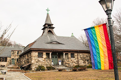
Pinballing back across Centre Street, on the same side as Sacred Heart, on the corner of Beacon Street, we find the Richardsonian Romanesque First Baptist Church.


Dedicated in 1888, the church replaced a previous wooden church. The stunning building "is significant as one of the earliest churches formed in Newton Center and the first of the Baptist denomination in Newton," per MACRIS. "Organized in 1780, the original meeting house was built on land given by Noah Wiswall, the first settler in this area of Newton. The original name given to the nearby lake of 'Wiswall's Pond' was thereafter called 'Baptist Pond' to reflect its use for baptisms during the 19th century. The church was also closely associated with the Newton Theological Institution, an important Baptist Seminary established on a hill to the southeast in 1825. Many of its pastors were also professors at the theological school. The most significant of its ministers was the Rev. Samuel F. Smith, who led the church from 1842-54. Smith is well known as the author of the national hymn 'America.'"
Baptist Pond is now known as Crystal Lake. The theological school is no longer located at the hill to the southeast. I will get to the latter property further in this report. I will also discuss the lake in a future Newton Centre post.
The church has some great details, below.


Further north on Centre Street, at the corner of Homer Street, sits the Greek Evangelical Church of Boston.
Built in 1904 as the First Congregational Church of Newton, this Neo-Gothic building succeeded four previous meeting houses built on this site. The parish dates to 1664, per MACRIS. The Greek Evangelical Church acquired this building in 1972.
Across Homer Street is Trinity Parish of Newton Centre.
While the Greek church "takes its inspiration from an English Country Church," per MACRIS, Trinity's "inspiration is English Perpendicular Gothic. Here the forms are solid, enduring in appearance because they are horizontal rather than vertical."
Dedicated in 1916, the church is the second meeting house to be located on this property. Per MACRIS, in 1892, there was a smaller building here. Subsequently, that building was moved to the Newton Centre playground, and was repurposed for the city's recreation department (about which more below). I love the Swiss chalet look of the attached parish house, below.

In 2015, Trinity merged with the Episcopal Parish of the Messiah, which had been in Newton's Auburndale village.
Newton has a significant Jewish population, about 30% in a city of roughly 89,000 people. There are at least five synagogues in Newton Centre. Let's check them out.
Congregation Shaarei Tefillah on Morseland Avenue has a relatively short, but fascinating history. From the congregation's web site: the group "began on 14 Tishrei 5744 (Wednesday night, September 21, 1983), when several Newton families hastily organized an Orthodox minyan for Sukkot in one family's Newton Centre home. They intended this minyan to meet only through Shabbat Bereishit, nine days later. Word of this minyan spread rapidly through the Newton Jewish community. On the first night of the holiday, the family's sunroom was filled to capacity."
I am not at all a spiritual person. But I have a fascination with churches (and, to a lesser degree, synagogues) and religious organizations. I respect their faith, commitment to traditions and sense of community. And I love reading about their humble beginnings, gathering in homes or basements of other congregations' buildings, so dedicated are they to their beliefs that they don't care where they assemble, as long as they are together.
Long story short, from the Shaarei Tefillah web site: the congregation moved its worship services from one place to another for a while, until landing in the basement of Trinity Church. Meanwhile, the group located a home on Commonwealth Avenue that it sought to convert to a synagogue. The group was unable, however, to get the OK from Newton's zoning board. In 1985, "Rabbi Mordecai Savitsky approached Shaarei Tefillah's leaders and offered to sell them his home at 35 Morseland Avenue," per the web site. After some renovation and expansion work, the congregation moved to this facility in 1990. In the top photo above you can see the renovated former house; the bottom photo shows a newer building.
Nearby, on Ward Street, is Congregation Beth El Atereth Israel, which has a much longer history than Shaarei Tefillah, per its web site. "Congregation Beth El-Atereth Israel...has a long history in the greater Boston area. Our Shul represents a continuation of two congregations founded in the 1800’s in the Dorchester area of Boston. In the mid 1950’s, the Shul began the first Orthodox minyan in Newton Centre.... This offshoot of the Dorchester Shul sparked the blossoming of a vibrant Orthodox community in Newton."
Should I feel bad that, while I'm quite interested in the stories of these synagogues, I don't care much for their architecture? Don't judge a book by its cover, I guess, right?
Across Ward Street from Beth El Atereth Israel is Beit Sasson, the Sephardic Congregation of Newton.
Located in a circa-1920 Colonial house, the congregation was founded in 1987 and originally met in the basement chapel of its neighbor across the street. The group maintains the traditions of Middle Eastern and Spanish Jewry, per its web site.
Going east on Ward Street, on the corner of Loring Street, we come to Chabad of Newton Centre, located in a former home that dates to 1916.
The congregation's web site doesn't provide details about its history.
Moving east yet again on Ward Street, we arrive at Temple Emanuel, quite a large synagogue whose founding dates to 1935, when it was housed in temporary quarters on Commonwealth Avenue. Newton's second synagogue, Temple Emanuel rose in 1937; an addition featuring a community hall and other facilities rose in 1952, per MACRIS.
I'm not sure whether Congregation Or Yisrael, which was located on the Hebrew College campus, is an active group. If so, then that makes six synagogues in Newton Centre.
Speaking of Hebrew College, it is located on the hill above Newton Centre's commercial district -- known historically as Institution Hill. This location was also home to a theological school that went under various names through the years. At its founding by Baptists in 1825, the school was known as the Newton Theological Institution, and was located on Ward Street. At some point, the school moved to "the mansion house of the old Peck estate," per this Newton Historical Commission document. The theological institution was the first school of higher learning established in Newton. In 1931, the institution became affiliated with the older Andover Theological Seminary, which moved to the hill. In 1965, the schools merged, forming the Andover Newton Theological School, per this web site. In 2017, Andover Newton became affiliated with the Yale Divinity School and moved its operations to New Haven, Conn.

In 2002, Hebrew College moved from nearby Brookline to Institution Hill. In 2018, the school announced the sale of its campus to Winthrop Park School, Inc. The agreement allowed the college to remain on the site for "several years" while it sought a new home; earlier this month the college announced that next year it will move onto the campus of Temple Reyim in Newton's Auburndale village. Winthrop Park School currently operates an educator institute for K-12 teachers as well as a college transition program "to address academic and social challenges that under-represented high school graduates face when transitioning to college."
"Winthrop plans to open an 'intentionally diverse' independent school for students in grades 9 through 12, and also will offer training for teachers and school administrators," said Steve Hinds, who serves as the organization’s founding president and president of its board of trustees, in the Globe article linked above.
In addition to several academic and administrative buildings, the campus on the hill features residential units, below.

Additionally, the Boston Psychoanalytic Society & Institute (BPSI), below, is located on the site.

Built in 1866 as a dormitory, the building that BPSI currently occupies is known historically as Colby Hall. A stunning building, it was named for Gardner Colby, who was treasurer of the school and also was the benefactor of Waterville College in Maine, which changed its name to Colby College in his honor, per Wikipedia.

(In front of the psychoanalytic building, a Little Free Library, on the left, and a bench dedicated to nearby resident Harry Kasper, "Who walked these grounds seeking truth and peace," before dying of a suspected, and suspicious, heroin overdose.)
There are many other buildings on this campus, but I wasn't too excited about trespassing further than the BPSI building.
In addition to the five active churches discussed above, there are two former church buildings in Newton Centre.

The former Methodist Episcopal Church is now home to a bookstore, a restaurant, a bank and offices. Built in 1880, the Richardson Romanesque church is one of many former meeting houses in Newton that have been converted to other uses.
In front of the old church, near the entrance, is a bell that was cast by C.T. Robinson & Co. for the First Baptist Society in 1888, per the inscription.

As I mentioned above, one of the former Trinity churches sits on the sprawling Newton Centre Playground, and is used by the city's recreation department.

Built in 1892 for the Trinity Parish, this structure was originally located on nearby Pelham Street. Six years later, it was moved to the site of the current Trinity Church, per this Newton Public Buildings Survey document. In 1916, it was move yet again to the playground, along Tyler Terrace. Known officially as the Jeannette Curtis West Recreation Center, it is known colloquially as The Hut. There was once a toboggan slide nearby, but it's long gone.

(Exterior of The Hut.)
Below is a somewhat grainy shot of the interior, taken a few years back when I picked up my daughter from a birthday party.
Let's move on to some current and former municipal properties.

The former Newton Centre library branch, above, dates to 1927. It is one of many former branch libraries built by the city between 1926 and 1939, per MACRIS. When the city built the mammoth and totally awesome main library in 1991, the branches were eventually shuttered. Some of them have since reopened through independent efforts.

(An artsy photo that I took several years ago of the old library's window.)
In May 2017, the city announced a plan to make over the old library site, adding a restaurant, a hotel, low-income housing and community space in partnership with First Cambridge Realtors. I have no idea of the status of this project.

I love the ivy on the circa-1928 fire department headquarters, above. Located along Centre Street, the building features a 9/11 memorial in front; several Newton residents were killed in the terrorist attacks in 2001. In the last few years, Schwartz/Silver Architects completed a large addition to the fire station.
The Mason Rice School, below, dates to 1959.

The current building represents the culmination of several schools that came before it. Per this Newton Patch article, "[T]he original Mason School was built [in 1852] as both a grammar school and a high school. It was named for David Haven Mason, a Newtonian who served as U.S. Attorney General under President Ulysses S. Grant....A second Mason School was constructed in 1870 to replace the original school. This wooden structure was located on Centre Street. In 1901, a new Mason School, also located on Centre Street, was built to replace the second building.
"The Rice School was built in 1870 to relieve overcrowding at the nearby Mason School. Originally called the Newton Centre Primary School, it was renamed in 1886 in honor of Marshall Spring Rice, a Newton resident who served as Town Clerk for over 27 years....The Rice School was used up until 1959 and at that time was the oldest public building still in use in Newton. In 1956, the Mason-Rice Parent Teacher Association published a pamphlet that detailed the inadequacies of the Mason and Rice schools and argued strongly for the need a build a new, joint Mason-Rice school to serve the children of Newton Centre."
And so there it is.
We can't forget about the largest and, perhaps, most important municipal complex in Newton Centre: Newton City Hall and War Memorial.

Built in 1932, the Colonial Revival-style building houses all (most?) branches of city government, as well as a memorial to Newton soldiers who have been killed in wars.

The extensive grounds were designed by the sons of famed landscape architect Frederick Law Olmsted. The public hub was built on or near the site of the former Crowell Auto Parts.


Located inside city hall is a series of dioramas recognizing the military service of Newton residents down through the centuries.
From the seat of power in the city, we move to the center of summertime fun, a place with some pretty cool history attached to it.
Located southwest of Newton Centre's main retail strip Crystal Lake and its attendant bathhouse are owned by the city. Public swimming is available during the summer; swimming outside the designated area is allegedly illegal. The lake was originally known as Wiswall Pond, as I mentioned above, named for Colonial settler Thomas Wiswall, who built a house in 1654 on the southwestern shore of the pond, per Wikipedia. I don't know what the Native Americans called the body of water.

(The bath house.)
The pond was officially christened Crystal Lake in the mid-19th century, according to Wikipedia, as it was thought to be better for marketing purposes. You see, by that time, the Paul family had taken over ownership of the lake, and was harvesting ice from its depths.
Ice harvesting was a common practice throughout New England in the 19th and early 20th centuries. There was a company called the George Ellis Ice Company (formerly Crystal Lake Ice Co.), which was a successor to the Paul family operation. The Ellis company was located where currently sit a brick apartment building complex on the corner of Centre Street and Norwood Avenue. The company was in business into the 1930’s, despite a fire in 1915 that destroyed much of the building.

(Open space located next to the bath house and parking lot; there was a house here until several years ago.)
As for the Gil Champagne Bathhouse, it dates to 1930 and was named for a former Newton police officer who was also the head of water safety within the Newton Recreation Department, according to this web site. Designed by Herbert Colby, the bathhouse was "constructed in stucco in a Spanish eclectic style with an arcaded porch facing the water and an entry with a curved parapet facing the street," per this 2010 Crystal Lake Task Force document.

It's a little worse for wear these days.

Prior to the bathhouse, a factory making fire alarms and telegraphs stood on this site, according to the Crystal Lake Conservancy. The factory's owner, Moses Crane, lived nearby. Crane eventually moved his manufacturing plant to Chestnut Street in Newton's Upper Falls village.
I'm going to talk about the Newton Centre post office next, and then get back to a city-owned former school and the adjacent soccer fields that have a quirky element.

Looks similar to the fire department HQ, don'tcha think? Built the same year, 1928, so that makes sense. Located on Sumner Street, the building is no longer the primary post office location in Newton Centre. There is a newer building around the corner on Beacon Street.
Heading south on Centre Street, turn east onto Locksley Road and you'll come across the John W. Weeks House.

Located in the former John Wingate Weeks Junior High (circa 1930), this 75-unit development offers 67 mixed-income apartments for seniors, as well as eight three-bedroom apartments for low-income families, per the building's web site. It is one of several former schools in Newton that have been converted to residential use.
Next to the old school is Weeks Field, where are located soccer pitches and tennis courts.

As well, there's a nice sitting area, where you can play chess or checkers.

Also, there is NewtonHenge.

Huh?
I first stumbled across this small, obviously man-made stone layout several years ago. I thought perhaps they were leftovers from something bigger that had once stood here. I was happy to learn recently, that these stones were not only placed here on purpose, but that they also serendipitously form an equinox sun dial somewhat similar to that at Stonehenge.

"Curt [Lamb] is the artist who it turns out created NewtonHenge – not 100 years ago but only 10 years ago," per this article from the Village 14 blog. "Says Curt, 'I created this to celebrate the history of the area but I had no idea about astronomy or the equinox when we built it.' As he was saying these words, the sun shone down through the two stones and illuminated a thin beam on the grass in front of the stones … much to the Druid’s delight," on the autumnal equinox this past September.
Lamb "created it to replace the oversized chair that used to be there," per a comment on yet another Village 14 article about this intriguing installment. "[H]e aligned these stones with the remnants of the old foundation of what must have been the Luther Paul barn."
So, we started off this post learning about a Morocco factory, and we end it by getting educated about a relatively new local landmark that aligns with the sun on the first day of autumn. In the second installent of the Newton Centre series I will look at, among other things, artwork of various types, plaques, the train station and some cool old apartment buildings and homes.
Below are the links to all of the previous posts about the villages of Newton.
I Seek Newton, Part IX: Nonantum (Section 3)
I Seek Newton, Part IX: Nonantum (Section 2)
I Seek Newton, Part IX: Nonantum (Section 1)
I Seek Newton, Part VIII: Upper Falls (Section 3)
I Seek Newton, Part VIII: Upper Falls (Section 2)
I Seek Newton, Part VIII: Upper Falls (Section 1)
I Seek Newton, Part VII: Thompsonville
I Seek Newton, Part VI: Chestnut Hill
I Seek Newton, Part V: Oak Hill
I Seek Newton, Part IV: Waban
I Seek Newton, Part III: Highlands
I Seek Newton, Part II: Auburndale
I Seek Newton, Part I: Lower Falls