Showing posts with label conservation land. Show all posts

Saturday, April 20, 2024

More Military Relics in the Home of the American Revolution

From Dave Brigham:

My hour-long hike through the Annursnac-Baptist Brook Conservation Area would have been perfect, but for the distant whine of leaf blowers. Sure, I was wandering through Concord, Mass., not the Australian outback, but is it too much to ask on a Sunday afternoon in late fall for folks to lay down their gas-powered lawn tools so an ordinary schmuck can have a peaceful walk through the woods while looking for ruins?

While I enjoy walking in the woods just for the heck of it, or to exercise my dog, I prefer doing so if there's a backside payoff. So when I learned that this conservation area had a history including not only military vestiges, but also remains from research done by the World's Greatest University, I knew I had to check it out.

This isn't the first time I've hiked through Concord seeking military relics. In the early days of the blog, I learned about a World War I-era rifle range in the tony Boston suburb, and sought it out (see December 4, 2012, "Concord, Part I: Old Rifle Range").

As for my Annursnac hike, within two minutes of setting out, I was looking at the foundation of an equipment storage building that was part of Harvard University's antenna research and test site in the late 1940s and into the following decade. Harvard purchased 63 acres of farmland in this area in 1949 for use by its Departments of Physics and Applied Science, according to this Town of Concord trail guide.

According to the web site for Harvard's John A. Paulson School of Engineering and Applied Sciences, in 1938 Ronold W.P. King joined the school's faculty (he would remain at Harvard until at least 1972). From King's Wikipedia entry: "His research group at Harvard spent the 1940s and 1950s developing the theory of antenna (radio), using the cylindrical antenna as a boundary value problem subject to Maxwell's equations....King is responsible for the inverted-F antenna, the most widely used antenna in mobile phones. However, he did not develop this antenna for that purpose. Rather the intended use was missile telemetry."

Further along the trail, I spied more ruins, this time a long-fallen antenna base.

After spotting the remnant of that downed radio tower, I was on high alert. Soon after, I was able to make out what was left of a utility pole.

Also in this area, I saw a curious site, which may not date to the days of Harvard's research program, but it surely is pretty damn old.

While all these sightings were great, the best was yet to come.

"At the northwest corner beside the main trail are the ruins of a 41-foot by 24-foot concrete structure and radio tower," per the Town of Concord trail guide. "Coinciding with the development of Hanscom Air Base in 1941, the U.S. Army Air Corps leased 16.5 acres to build and operate a facility for tracking aircraft arrivals and departures from the airfield, and as a radio direction/finder station. The structure is believed to be part of that installation....From 1959 to 1969 it was an off-base installation known as the U.S. Air Force Strawberry Hill Electronics Research Annex."

Man, I love to learn about stuff like this. What was once farmland was turned into not one, but two, installations related to antennas and aircraft tracking, and then, after the lifespan of those projects ended, nature reclaimed the land (helped by conservation efforts).

As with many places like this I come across, it's obviously a major hangout for kids/teens/twentysomethings. I was intrigued by a barrel at this site, with the word "SOCONY" on the top.
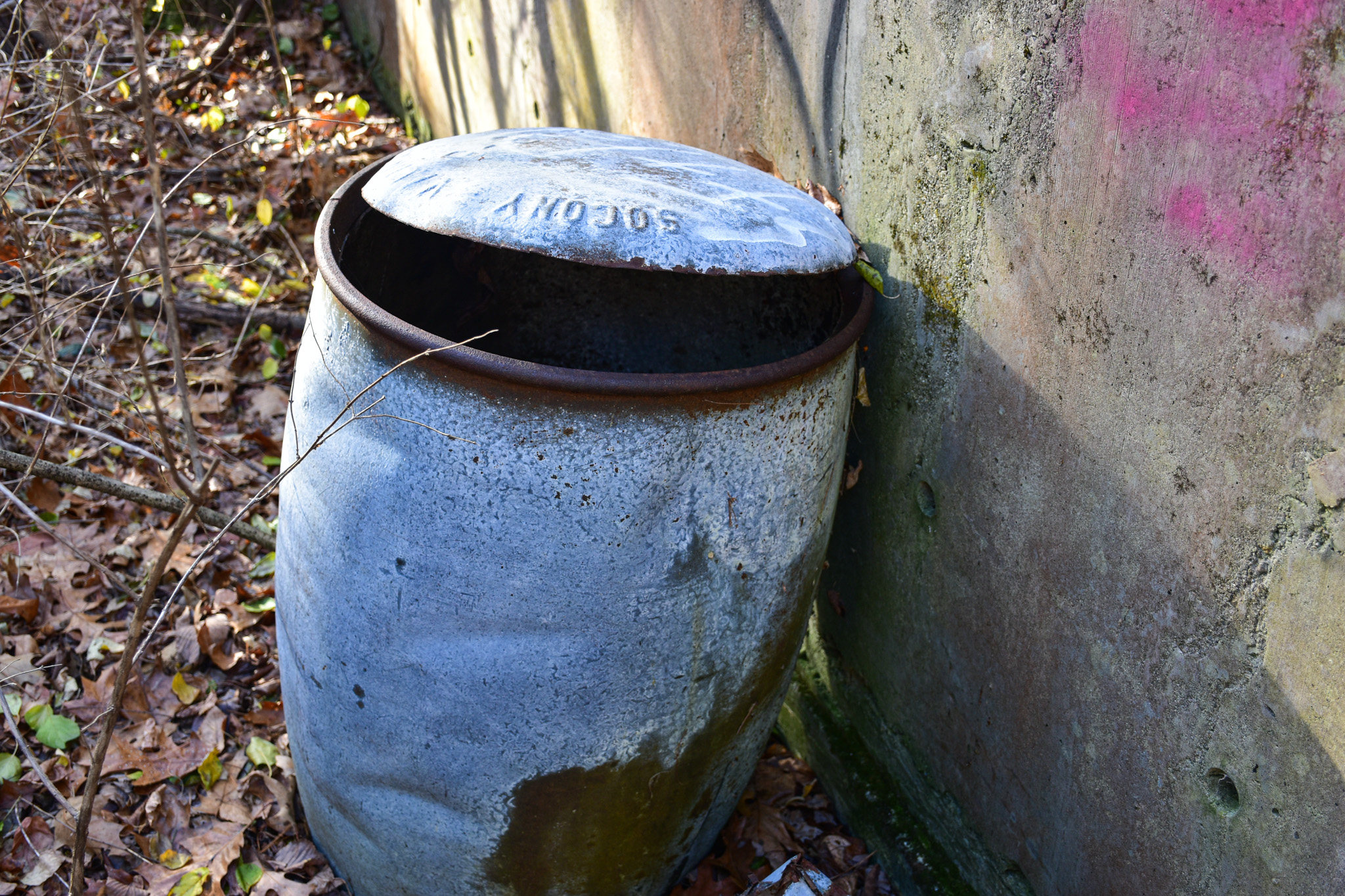
A quick Google search turned up that SOCONY stood for Standard Oil Company of New York, one of the 43 entities created by the 1911 Supreme Court decision breaking up Standard Oil. In 1931, SOCONY merged with Vacuum Oil Company, "from which the Mobil name first originated," according to Wikipedia. "Over time, Mobil became the company's primary identity, which prompted a renaming in 1955 to the Socony Mobil Oil Company, and then in 1966 to the Mobil Oil Corporation."

I can't be sure that this barrel is one used for oil on the old U.S. Army Air Corps site, but I'd like to think that some kids dug it out of the woods a long time ago.

As for the Annursnac trail, it continues north into neighboring Acton, and becomes the Stoneymeade Conservation Land. Click that link and read about what you'll find on the conservation land, and learn about the history of Stoneymeade Farm, which dates to Revolutionary War days.

Sunday, March 24, 2019

Weston By Musket and Sextant

From Dave Brigham:

This trestle was on my mind for years before I finally made the opportunity to meet it. I've been drawn to railroad tracks since I was a kid walking on the rails of the New York, New Haven & Hartford system that ran through my hometown of Weatogue, Connecticut. My friends and I would gather beer, soda and liquor bottles that teenagers and hobos (?) tossed down the slopes alongside the tracks, line them up on the rails and smash them with rocks. We traversed the tracks to get to a nearby convenience store and old-timey candy shop. We also tromped around by Boot Pond, which ran along the west side of the tracks, and crawled through the tunnel that drained the pond into a swamp on the east side. My first suburbex mission, when I was perhaps 14 or 15, was exploring a house near the swamp that had been abandoned with all of the owner's possessions inside (see September 20, 2011, "In Search of President Little" and February 7, 2013, "President Little, Part II: From Myth to Man").

Sometime in 2016 I realized that there were abandoned railbeds wending their way through Waltham, Watertown, Weston, Wayland and other towns near where I live (see August 1, 2016, "I Rail Against Trails (Not Really, But I Don't Every Abandoned Set of Train Tracks Converted for Cyclists and Roller Bladers"). I traced the right-of-ways on Google Maps and then sought out and explored some of them (January 5, 2017, "Brigham in Waltham, Part II"). I saw on Google that a long-abandoned trestle over Route 128/95 in Waltham led to an old right-of-way that cut behind a plywood supply company and in front of an office complex, leading to a bridge over the MBTA's Fitchburg commuter line and on in to Weston and beyond.

I kept this trail and bridge in the back of my mind for the next few years as I explored, researched and wrote up plenty of other things here. Finally, one day last fall I made time to check out the trestle. I wasn't sure, however, exactly how to get there. I drove across Route 128/95 and a little ways west on Route 20, to the complex where both Monster, Inc. and Biogen have their headquarters. There didn't seem to be any public parking there, even though the location is quite close to the trestle and a new rail trail. Then I doubled back to Route 117 and drove past the plywood supply company and the office complex mentioned above. Again, no obvious public parking. So I drove a little west on 117 and down a residential street that dead-ended near the bridge and the rail trail, but again no obvious place to park and hike in from.

So I parked near the former train station that I'd checked out as part of a long blog post about the Kendal Green historic area of Weston (see June 23, 2017, "A Walk Through Weston's History"). I should have just gone straight here, as I had a feeling this is where I was gonna end up.

(The former Weston train station. I'll come back to this at the bottom of this post.)

From the train station, I hoofed it about three quarters of a mile and finally saw the trestle that I'd seen from above on Google Maps, and that I'd dreamt about (literally) for quite some time. And it looked great.

(The trestle for the former Massachusetts Central Railroad -- also known as Central Massachusetts -- as it goes over the commuter rail tracks in Weston.)

(Looking west from the trestle at the rail trail. The trail does not continue east toward the highway. I had to step around a fence to get to this point. Yes, I know, I live dangerously.)

Having finally reached this trestle, I thought about walking back to the old train station, getting in my car and calling it a day. But I knew there was no way I was doing that. Immediately to the north of the rail trail is the Weston Transfer Station and a field with solar panels, so I knew I couldn't veer off in that direction. To the south, however, stood a small, wooded area raised above the tracks, separating the trail from a small pond on the Monster/Biogen complex, which I remembered is on the site of a former quarry. I had a hunch I'd find something up there.

It didn't take long.

I'm not sure what these rusted pipes were for, but I sure as hell figure they were related to the quarry. The rock-mining operation was run by Massachusetts Broken Stone Co., which was incorporated in 1908. The company operates quarries in Holden and Berlin, Mass. I'm not sure when the Weston hole was shut down, or when it opened, but Mass. Broken Stone began looking to redevelop the site as far back as 1986. In 2001, the company sold the land to a developer. I guess the tire came off a vehicle from the rock hole as well, many years ago.

As for this bench, which is bolted down, I suppose quarry workers took lunch and smoke breaks up here. I don't know why else it would be here. Other than thrill-seeking teenagers with their vaping paraphernalia, and yours truly, I don't think too many folks have been up here lately.

(View of the transfer station solar panel complex, as seen from the long, narrow, steep hill I explored above the rail trail.)

After skittering down the hill and back to the trail, I got this view of what's called Weston Station Pond.

(Weston Station Pond, which separates the rail trail from the Monster/Biogen office complex. I'm not sure whether this is a natural element, or something left over from the quarrying days.)

My next stop as I walked back toward the old train station was Land's Sake Farm, located just steps from the rail trail. The town of Weston purchased the farm from Harvard University in 1985. Prior to that the land was part of the Case family estate.

(Saplings at Land's Sake Farm.)

(Bee hives at Land's Sake Farm.)

(Close-up of bee hives at Land's Sake Farm.)

(Old something-or-other at Land's Sake Farm.)

I'd seen the farm, of course, on my way out to the trestle, and knew I wanted to explore. My next mini-excursion, however, was a pleasant surprise.

I love WASPs, as you know (search the blog; I'll wait. OK, all set?) I particularly love old-money blue bloods when they donate land in perpetuity for conservation. Maintained by the Weston Garden Club, the Forbes Conservation Land just off the trail was donated in 1985 by Celeste and Mac Forbes. At 2.5 acres, the site is small, but nicely maintained with paths, maps and bridges.

So who were Celeste and Mac Forbes? I have no idea. But with that name and the fact that they were in a position to donate a few acres of land, you know they were doing alright.

On the opposite side of the trail is the Sears Land.

I didn't explore this area, but I wish I had. Accessible off Crescent Street, which is how one also reaches the Land's Sake Farm, the Sears Land -- on which sits something called the Melone Homestead -- the Sears Land is small but contains some nice walking paths, dams, dried-up canals, old spillways, bridges and ruins of a factory that once made school furniture (!). Here's a video that shows you what to expect if you hike here. I plan to get there soon!

Go for a Walk! Sears Land from Weston Media Center Inc. on Vimeo.

Finally, I was back at the old Weston train station.

Built in 1881 and closed in 1971, the station was once part of the Massachusetts Central Railroad and was located on a spur that split in nearby Waltham. This building is also privately owned, and may have been a home at one point. It's not very well maintained.

For more about Weston, see February 17, 2017, "Stone Cold Surprise" and September 5, 2015, "Bigelow's Little Office."

Here's your headline explainer:

Tuesday, November 21, 2017

Punk Farm?

From Dave Brigham:

The most obvious ulterior motive in my life manifests itself on this blog. I've taken my wife, my kids and even my mother along on explorations in service of the backside of America. A few Thanksgivings ago, I managed to roust a fair number of my extended family to trek along an old stagecoach route in my hometown (see February 4, 2016, "Stealing Back Into the Past of My Hometown"). On occasion I drive the long way to get places in order to snap photos of a piece of hidden history.

Sometimes, though, I head out for a hike just for hiking's sake. And yet my quest for the forgotten world wins out anyway.

Such was the case on a recent outing with my son, Owen.

After searching Google maps for a nearby conservation area, I decided on Rock Meadow in Belmont, Mass. I've hiked near this spot over the years, but had forgotten until Owen and I arrived at Rock Meadow that this was the entry point I'd used two decades ago when mountain biking with my wife and a friend to get to the abandoned Metropolitan State Hospital (see March 20, 2017, "Brigham in Waltham, Part III").

Owen and I saw numerous mountain bikers during the course of our short walk. The paths are well-worn and easy to traverse. We chatted about how things were going in school, said "Hi" to several dogs and their owners and enjoyed the cool autumn temperatures.

Returning to the small dirt parking lot, I saw through the woods something that I'd missed upon our arrival.

Originally part of the McLean Hospital farming operation, the building dates to around 1918 and was used as a dairy barn. Located across the street, McLean sold the land now known as Rock Meadow to the town of Belmont after the hospital's farming efforts petered out. The building is solid despite its appearance. There have been efforts by preservationists to resurrect the brick edifice, but to date nothing is planned.

The barn is quite stately, and I'm sure that with a lot of elbow grease and an even greater amount of money, it could be turned into a fabulous place for meetings, concerts (all-ages punk shows!) and other events. I hope this happens and will of course keep readers updated.

I understand, of course, why this building has been saved. But I'm not sure why the low outbuilding next to it hasn't been fully torn down and removed.

For more about barns and Belmont, read "Crouching Barn, Hidden Mill," a post I wrote in November 2012.

Checking Out Dudley Street in Roxbury...and a Historic, Pre-Civil War House

From Dave Brigham: As part of a series of quick-hit jaunts through Boston this spring, I checked out the outer reaches of Nubian Square, m...