Showing posts with label ruins. Show all posts

Saturday, May 10, 2025

Newburgh NY - Industrialization, Revitalization and Crime

From Mick Melvin:

I travel often from Connecticut to Pennsylvania to visit family and friends. I take Route 84 west to New York on most trips to avoid going through NYC. I have to cross the Newburgh Bridge in New York as I make my way down. I stopped in the town of Newburgh on one trip to get some gas, which sparked my interest in the town. I made a plan to stop there on a recent visit to see my father on Good Friday and I’m glad I stopped through.

I did a bit of research beforehand to get a lay of the land. I spotted a factory along the Hudson River so I figured it would be a good spot to start. The factory was once the site of The Newburgh Steam Mills on North Water St. The building was built in the mid 1800’s and brought a lot of business and employment to the area. The factory, which processed cotton, employed over 300 employees. As this was my first time in the area, I only took a few shots of the building from the street side, but I found out later that I could have walked behind the building also. (Next time!)

The building was bought and transformed into a lawnmower factory in the late 1800’s after the decline of cotton manufacturing. The Chadborn & Coldwell Manufacturing Company of Newburgh operated into the 1940’s before eventually merging with Toro brand lawnmowers. The building was once again sold and transformed into the Regal Bag Company. The company ran the business from the property for almost 73 years and sold it in 2024.

The building now contains businesses on the 5th and 6th floors. On the 6th floor, there is a company that makes backdrops for Broadway shows. The fifth floor has many spaces for artists and artist studios. Fun fact - the building is listed in Ripley’s Believe It or Not! as the only building that has its main entrance on the 6th floor.

After taking a few shots, I ventured closer to the marina to check out some sites along the Hudson River. There were other brick buildings that also looked to be former factories/businesses. Most of the buildings have been transformed into restaurants. The weather was nice for an early spring day, which brought a pretty good amount of people to the area. I’m sure that the area will be much busier with the weather getting warmer. I’ll have to go back later in the spring or summer to see.

My curiosity for something more “Backside” drew me even closer to the water. To my delight, I spotted a few old vessels docked along the shore. I don’t know what these vessels were used for or how long they were left there, but it lets us know there was some shipping activity along this part of the Hudson River.

Being so close to the shore gave me a great view of the town of Beacon across the river. The Newburgh-Beacon ferry can be taken from the marina back and forth across the Hudson River connecting Newburgh and Beacon, N.Y. The ferries only run on weekdays as a rush-hour service for commuters to NYC. Ferries are timed to connect at Beacon with Metro-North trains to and from Grand Central.

I will definitely be back to take more shots in this interesting town. My research of the town led me to the fact that Newburgh is in the top 10 of cities in the U.S. in violent crime. I will have to be careful when taking a trip further into the town. The town is in the process of revitalizing the area as it is reported that there is much blight like a lot of towns in the U.S. I’m anxious to view some of the old architecture and layout of downtown Newburgh. I will keep you all posted. Wish me luck!

Saturday, September 21, 2024

Franklin Park Is Ruin-ed

From Dave Brigham:

Like Ben Franklin with the kite, gettin' over with the key, I was shocked into action when I realized how little I knew about the jewel of Boston's park system, the largest component of Frederick Law Olmsted's Emerald Necklace: Franklin Park.

In May of this year, I wrote about the wonderful remnants of a Franklin Park superintendent's office (see May 11, 2024, "Learning About Boston's Schoolmaster Hill"), as well as the stadium at the park (see May 18, 2024, "Stadiium Tour in Franklin Park"). Near the end of 2019, I posted about the Franklin Park Zoo's old bear dens (see December 18, 2019, "Having a Bear of a Time at the Zoo").

Still, I realized after those most recent adventures just how much more there is to the park. So I explored further. Here's what I found.

I started my tour at the Ellicott Arch and adjacent 99 Steps.

(The lower end of 99 Steps, located in the southwestern corner of the park, just off Circuit Drive.)

(Ellicott Arch, which passes under Circuit Drive.)

(Inside the arch's tunnel.)

As mentioned above, this expanse was designed by renowned landscape architect Frederick Law Olmsted. It is his nephew and adopted son, however, who gets credit for designing the Ellicott Arch. John Charles Olmsted and his brother, Frederick, Jr., took over their father's firm after the elder man retired. The arch, constructed of Roxbury puddingstone taken from the area, was completed in 1899. The 99 Steps, which are made of the same stone, wind up into the wooded area of the park known as the Wilderness.

I've been unable to find out for whom the arch is named.

Mid-way up (or down, I suppose) the steps is a plaque detailing things that were illegal when the park first opened (and, presumably, today).

"It is against the law for anyone when in the park...to make outcries, orations, or harangues...play hand-organs...use vile, profane, or threatening language..." the sign says in part.

Not too far away from these architectural beauties is a more rough-hewn work of art, albeit one that's had a tough time of things in recent years.

Located near a swampy area below some cliffs, the Wizard of Franklin Park is a shadow of its former self, from what I understand. In late May 2021, Universal Hub ran an article about the rebirth of the Wizard: "Earlier this month, as people were beginning to notice fires being set in Franklin Park, whether intentionally or through cigarette carelessness, a Jamaica Plain resident discovered that among the victims was the tree wizard that had long sat in the hollow of a tree in the park's Wilderness area off Forest Hills Street - not just set on fire, but hacked up as well."

Pardon my French, but what the fuck is wrong with people? Who sets fires in a park as glorious as Franklin Park? And who attacks a harmless wizard painted on a tree?

The article continues: "Alex Cook, who knows something about outdoor art, went out a few days ago and rebuilt and repainted the tree wizard." So that was more than three years ago. When I visited in March of this year, the tree looked like it had perhaps been set ablaze again.

While I knew about the Wizard, the arch and 99 steps from advanced research, I wasn't aware of other sites of interest I would come across.

These stone walls are located in the northeast section of the aforementioned Wilderness area, near what are called the Valley Gates. According to this excellent blog post, this area was to be known as The Ante Park, a section "[s]eparating the two halves [of the park], putting a physical and psychological barrier between the natural enjoyment and the community uses of the park."

The natural enjoyment section included the Wilderness and the Country Park, the latter of which is now Franklin Park Golf Course. The community-oriented part was the Greeting (now the Franklin Park Zoo) and the Playstead, home of White Stadiium and other ruins that I will discuss below. The wide lane you see in the first photo above was once known as Glen Lane, a road running through the Valley Gates from Washington Street to Blue Hill Avenue, according to the blog.

Like me, the blog's author was mystified as to the original purpose of the stone walls. I highly recommend reading the entire post, but here's a summary of what the writer found out: he thought at first maybe these were remnants from the zoo, but learned quickly that that wasn't a good guess. He next considered it was an area for park visitors to keep their horses. Nope. Finally, after more intense map reviewing, "I saw that the rocky alcove existed in 1884! [On the map] the space is clearly marked right where I saw it....Which means that it was not part of the Franklin Park plan, but a remnant of some pre-Park farm or home."

Nice detective work!

OK, let's move on to the ruins near White Stadium.

This is what's left of the Overlook, "an 800-foot-long viewing platform elevated above The Playstead," according to this Boston Preservation blog post. "There was a shelter heavily designed by Olmsted on top of the The Overlook. The City allowed it to fall into disrepair and a fire took the building. It is now only a ruin today."

The Overlook was a place for people to gather and watch sports, ceremonies and other exhibitions taking place below, in the Playstead. Judging by the ruins, it was quite a structure.

(Remnant of a water fountain near the Overlook.)

The last two features I want to highlight are two statues at the Playstead entrance to the zoo. I've walked past these works of art many times over the years, but hadn't really appreciated them.

You are likely familiar with the Lincoln Memorial in Washington, D.C. Well, the same artist who sculpted the massive seated figure of our nation's 16th president, Daniel Chester "D.C." French, created the works outside the zoo. The one above is known as Labor; it is "fifteen feet high and consists of a seated Labor in leather apron with his right arm on an anvil which also protects a mother cradling her baby," according to this Jamaica Plain Historical Society blog post. "At his right is the rhythmic figure representing Arts."

The statue's full name is Labor Supporting the Arts and Domestic Life.

Labor and its partner, Science (The Forces of Steam and Electricity Subdued and Controlled by Science) (seen below), were created in the late 18th century for the former Boston Post Office and Subtreasury Building. "[T]he figure Science is a seated woman with her foot resting on a closed volume, representing her concealed secrets," per the historical society blog post. "Crouching at her feet is a gigantic slave with his hands chained to a steam locomotive wheel. Standing at her right is an energetic young man clutching a thunderbolt as the Spirit of Electricity, his youth symbolizing the emerging potential of the new resource."

Erected in 1885, the statues were situated approxiately 100 feet above Congress Street flanking a two-story entry arch. "They were among [the] largest sculptures in the city; they joined the Soldiers and Sailors monument on the Boston Common...the Charlestown Soldiers and Sailors monument...and the George Washington monument at the Public Garden," according to the blog post.

As amazing as the statues are, and as beautiful as the post office building was, the pairing would not last. "The Pubic Buildings Act of 1926 authorized $165 million for new federal buildings and the city of Boston applied for and received an appropriation to replace the 1885 Post Office and Subtreasury Building," the historical society continues. "By the end of December, 1929, the massive city block-long building had been razed."

The statues were removed from the building before its demolition, and offered to the City of Boston. On September 17, 1930, the statues, with new granite pedestals, were revealed to the public at the zoo as part of the celebration of the 300th anniversary of Boston's founding. The site where the statues originally stood is now the John W. McCormack Post Office and Courthouse Building, located in the heart of Boston's Post Office Square.

I strongly encourage my readers to explore Franklin Park. There is still plenty of the site that I haven't checked out; I hope to return soon.

Saturday, June 29, 2024

Skirting a Superfund Site to See Some Ruins

From Dave Brigham:

Located in a "four corners" area where Acton, Sudbury and Maynard meet with the southwest corner of Concord, Powder Mill Woods Conservation Area is a peaceful little oasis with an explosive past.

Nestled between residential developments, the Thoreau Club (about which more below) and a Superfund site (also about which more below), Powder Mill Woods is the latest tucked-away area of intrigue I've explored in Concord (see April 20, 2024, "More Military Relics in the Home of the American Revolution" and December 4, 2012, "Concord, Part I: Old Rifle Range").

"The area has a 100-year history of gunpowder manufacture, the depressions in the landscape ideal for protecting individual buildings," according to the Town of Concord's Powder Mill Woods Trail Guide. "Trails follow 19th-century cart paths and narrow gauge railroad beds once used to move materials among separate buildings of the production process."

I knew from looking at the trail guide ahead of time that I'd stumble across the twisted rails shown below, but I still was pleasantly surprised.

"These narrow-gauge rails are relics of a railroad used by the American Powder Mills and other gunpowder manufacturing companies that once operated here," according to a sign posted next to this display of gnarled metal. "Horse-drawn rail-mounted carriages hauled materials on the railroad from as early as 1880 until at least 1913."

There are other small remnants spread throughout the woods.

As I strolled along, I was aware of fences and "No Trespassing" signs along the northern perimeter. That's because between the conservation area and Main Street, there is the Nuclear Metals, Inc., site. "The Nuclear Metals, Inc. site – also known as the Starmet Corporation site – is located on a 46-acre parcel in Concord, Massachusetts," according to this U.S. Environmental Protection Agency web site. "Nuclear Metals made depleted uranium products, primarily for armor-piercing ammunition. It also manufactured metal powders for medical applications, photocopiers, and specialty metal products such as beryllium tubing used in the aerospace industry. From 1958 to 1985, waste was discharged into an unlined holding basin. Facility operations contaminated soil and groundwater with hazardous chemicals. Following immediate actions to protect human health and the environment, the site’s long-term cleanup is ongoing."

I'm not sure what will become of the site once it has been cleaned up entirely.

I knew from the trail guide that there were ruins in the area, so I kept tromping until I found them.

Gunpowder production began on this site in 1835. "At its peak, production involved forty buildings scattered throughout the 400-acre area in Acton, Concord, Maynard, and Sudbury," according to the trail guide. "The mills produced 1,000 lbs. (450 kg) of gunpowder per day during the American Civil War."

"Ruins of these buildings and the roads between them can still be found in the land along Forest Ridge Road, both sides of Route 62, and in the Thoreau Club property. Remnants of a large concrete building can be seen beside the old roadbed that passes through the northeast corner of the Thoreau Club land."

Those concrete ruins are what I photographed here.

Nearby I checked out some cabins associated with the Thoreau Club's summer camp.

The club was founded in 1951 by Clifford and Dorothy Pulis. The camp "was the fulfillment of a dream to create a day camp where they could share their love of nature, the outdoors and their camping expertise," per the club's web site. "Incorporating their own wilderness camping experiences and a quote from Henry David Thoreau’s Walden, 'Every morning an opportunity to make life of equal simplicity with nature,' the...Pulis team created a unique camp environment that captured the feeling of the deep woods of Maine in rural Concord, MA."

Saturday, May 11, 2024

Learning About Boston's Schoolmaster Hill

From Dave Brigham:

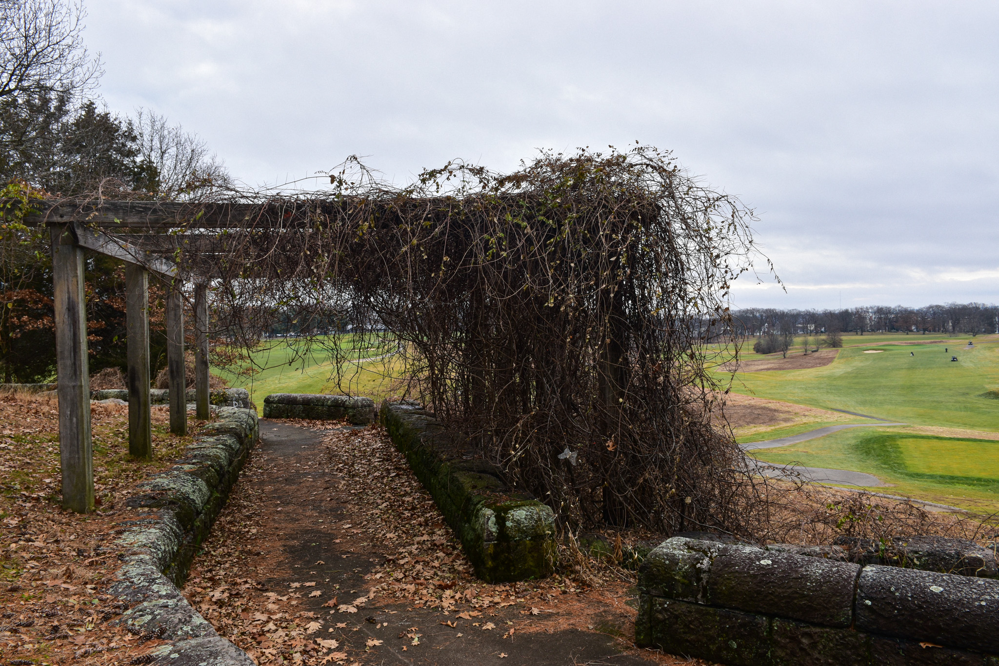
As ruins go, the remnants of the superintendent's office in Boston's Franklin Park are about as clean, beautiful and well-built as you'll find.

Located in the heart of the park, overlooking the public golf course, the ruins are the main attraction of Schoolmaster Hill, so named because 200 years ago, this area was home to Ralph Waldo Emerson, his brother and his mother. In his early 20s at the time, the man who would go on to become an inflential preacher, writer, lecturer, poet and philosopher was working as a teacher in Roxbury.

While he didn't live here long, the time he spent in what was then the very rural area known as Canterbury influenced his life. "Emerson spent his spare time walking, reading and writing in his journal," according to Ralph Waldo Emerson: The Schoolmaster of Franklin Park, a book published in 1980 by the Franklin Park Coalition. "The journal entries give a good picture of how Emerson felt about living in Canterbury. And it is from these books that we learn whether the solitude of the woods and meadows was beneficial to the confused, bored young man."

The book quotes Emerson's journal: "I never saw a country which more delighted me. A man might travel many hundred miles and not find so fine woodlands as abound in this neighborhood."

Designed by Frederick Law Olmstead in the late 19th century, the 527-acre Franklin Park, which also features a zoo, a stadium (about which I will write in the near future) and old bear dens (see December 18, 2019, "Having a Bear of a Time at the Zoo"), "is the largest and last component of the Emerald Necklace created by...Olmsted," according to Wikipedia. "Although often neglected in the past, it is considered the 'crown jewel' of Olmsted's work in Greater Boston.

I had the ruins to myself on the late fall day that I visited. I found the stone walls -- amazingly untouched by graffiti -- to be pleasant photography subjects. I wandered at my leisure, comforted by the far-off sound of golfers hitting their drives, chatting with each other and gently revving their carts.

The property was "[o]riginally 'covered by vines on trellises and furnished with tables and seats,' [and] also provided complimentary hot water for visitors to make tea," according to this National Park Service web site. "A multi-use building, it at one time housed the superintendent's office and served as the golf course club house."

There is a plaque on a boulder memorializing Emerson's time here, and sharing some of his poetry.

Make sure to check back for my write-up of Franklin Park's White Stadium, which stands to change drastically in the near future, and another post about features of the park.

Way Down Yonder in Pawtucket, Part I

From Dave Brigham: I apologize in advance for this, but I often feel the need to explain my headline choices: I'll admit that befo...