Showing posts with label gatehouse. Show all posts

Saturday, December 20, 2025

In the Valley of Belmont, Part III: Cushing Square

From Dave Brigham:

Named for the wealthy sea merchant and opium smuggler whose vast estate gave the town its name, Cushing Square is situated in Belmont's southern climes, bordering Watertown. For the purposes of this blog, I will stretch the boundaries of the retail district a bit to the north and east.

John Perkins Cushing was born in Boston in 1787. "When his mother died of smallpox, Cushing was raised by his uncle, slave and opium trader Thomas Handasyd Perkins," according to Wikipedia. "In 1803, at age 16, Cushing sailed for China to become clerk in his uncle's counting house," Wikipedia continues. "The head of the firm in China soon fell ill and died at sea. Thus, when Cushing arrived in China, he found himself Perkins & Company's sole agent, remaining there for nearly 30 years."

The firm imported and traded rice in China, and also engaged in money lending, Wikipedia continues. Perkins & Co. was also involved in fur trading, but when that business began to flag, the operation settled on the opium trade. In 1830, Cushing returned to Boston, where he married, raised a family and established Bellmont, a 200-acre estate.

He died in Belmont in 1862, three years after the town was established. His estate was located in the area where Payson Park is located.

OK, now that we've gotten the seedier business out of the way, let's learn more about the Greater Cushing Square area. This is the last of three posts about the commercial areas of Belmont (see December 6, 2025, "In the Valley of Belmont, Part II: Waverley Square," and November 22, 2025, "In the Valley of Belmont, Part I: The Center"). Links to other posts about the town are located at the bottom of this post.

This tour starts at the Payson Park Reservoir, which is located in the neighborhood just north and east of Cushing Square. "After Cushing’s death...Bellmont was sold to Samuel Payson, a textile manufacturer," according to this Town of Belmont document. In 1886 Payson sold the property to the Payson Park Land Company, which developed the residential streets.

I have a thing for gatehouses (see February 18, 2023, "The Loveliest Gatehouse,"; April 10, 2021, "I Seek Newton, Part X: Newton Centre (Section 3)," and scroll down for two examples; December 5, 2016, "I Seek Newton, Part VI: Chestnut Hill" and scroll most of the way down), so when I saw on Google Maps that there are a few at the large cistern owned by the City of Cambridge (WHAT?!), I had to check them out.

Bounded by Common Street to the west, Belmont Street to the south, Washington Street to the north and School Street to the east, the Payson Park neighborhood "underwent several stages of residential development between 1886 and 1930," according to MACRIS. It's a very pleasant area; its "historical significance rests in its current existence as an essentially intact example of early 20th century suburban development," MACRIS continues. "It reflects the impact on a large 19th century country estate of streetcar and automobile generated (sic) urban accessibility."

The reservoir was built between 1894 and 1898, after the City of Cambridge took the site by eminent domain, MACRIS indicates. "[I]t stands on the site of suspected Contact Period Indian activity," MACRIS explains. "In the 20th century the reservoir [was] the subject of several construction, water rights, and security controversies."

Cambridge still owns the 163-acre parcel. The reservoir holds 43 million gallons of drinkable water, and is located less than a mile from Cambridge's Fresh Pond Reservoir, as the crow flies. The two have a symbiotic relationship.

"Every day, between 12 and 16 million gallons of water is withdrawn from Fresh Pond, run through the plant and then pumped a half-mile uphill to an elevation of 176 feet at Payson Park, from which it flows by gravity to a central distribution point at the [Cambridge] Common, providing the water pressure needed for it to wind up ultimately in homes, schools and offices," according to this undated article from the Cambridge Water Department.

This isn't the only water reserve that Cambridge maintains outside its city boundary. The Cambridge Reservoir, also known as the Hobbs Brook Reservoir, is located just west of Route 128, straddling the towns of Lexington and Lincoln, and the city of Waltham. Cambridge also gets water from the Stony Brook Reservoir in Weston.

Anyway! Let's talk about those beautiful Romanesque gatehouses, which date to 1896.

Located at the top of a steep set of steps along Payson Road, these circular structures are really quite something. The details are magnificent, the design beautiful and the restoration applause-worthy. As you can imagine, they had fallen into disrepair over the generations, with MACRIS indicating in a 1982 report that they were "threatened by neglect," and that the main house had lost its pointed roof in 1967 and a "significant portion of its outer yellow brick wall facing."

Nowadays, when a utilitarian building of this sort is designed and built, it tends to be quite plain and boring. I understand that putting significant finances behind a structure that mainly exists to cover up infrastrcture isn't something that many public or private entities think makes sense. But I appreciate the efforts from the turn of last century.

Interested to learn more about the gatehouses, while also reading about someone's lunch of snow peapod noodles and her neighbor's concern about Dutch Elm disease? Then check out this blog post.

Below are two more images of the reservoir.

The Payson Park Land Company developed Bellmont and 15 acres of land for the Belmont School for Boys, a boarding school, according to Town of Belmont document. I'm unclear whether that school is the same as Belmont Hill School, which was founded in 1923. The school constructed a chapel in 1892. In 1930, the chapel was given to the town. It has served as the Benton Branch Library since then.

The quaint English Revival building "is of unique architectural style in the Benton neighborhood, particularly notable as being the only pre-1900 building in this portion of Belmont that has not been moved or inappropriately altered," MACRIS indicates.

OK, now that I've spent WAY more time on Payson Park than I'd originally intended, let's get to Cushing Square.

Perhaps the most notable building in the square is the Winters Block, a stately English Revival building located just to the southeast of the intersection of Common Street and Trapelo Road.

"Cushing Square developed in the early 20th century as a commercial center for the adjacent Payson Park residential neighborhood," according to this Town of Belmont document. "Both Trapelo Road and Common Street were important historically – Trapelo Road (originally North Street) was the road to Waverley and Common Street was the principal way from Watertown to Belmont Center. However it was the arrival of the West End Street Railway in 1891, offering streetcar service from Waverley to Boston via Cambridge, that made the area what it is today. At that time each road was widened to 75 feet to accommodate center tracks."

"In 1925 P.R. Winters opened Winters Hardware on the ground floor of a building he had built at 80-86 Trapelo Road," the document continues. "Four years later, a large addition was constructed to the east of the original building at 72-78 Trapelo Road. Like many residences being built in Belmont during the period, the Winters Block was designed in a Tudor Revival style with an exterior decorated by stucco, half-timbering and steeply-pitched gables projecting from the slate roof."

I love a nice clock. I also dig the fact that the original business is still here!

On the north side of Trapelo Road, a little to the east, is the Attacca School of Music, which is located in a former bank.

Named for a musical instruction used to indicate that the next section should follow without a pause (thanks Dictionary.com!), the school offers private programs in piano, violin, viola, guitar and cello.

As for the building, it was constructed as a branch office for the Harvard Trust Company in 1935. In ensuing years, Harvard Trust was swalloed up by Bay Bank, and this building served as a bank until 1993. It was then occupied by an insurance company, and perhaps other outfits, before the music school took over.

I continued east, to the intersection of Trapelo Road and Belmont Street. I wanted to take a look at the building where one of the last Brigham's Ice Cream shops in the world once stood. That location shut down in January 2012 after nearly 80 years in business. From there, I crossed the street and headed back toward the heart of Cushing Square, but as you'll see a bit further down this post, I ventured east by car later in my adventure.

Catercorner (one of my favorite words) from Winters Hardware is the Thomas A. Dewire building, which houses several small retail operations. I like the contrast of the building's name carved along the roofline with the much less permanent sign for #1 Food Mart.

Around the corner on Cushing Avenue is House of Lavash, which specializes in traditional Armenian flatbread.

I really like that sign.

There are numerous one-story retail buildings in the square. Along Common Street is a Colonial Revival strip that dates to 1931.

At 105-115 Trapelo Road is the Zebedee Cliff Block, which was built in the mid-1920s. It is one of many of what MACRIS calls "taxpayer blocks, which "provide shops and services for the area’s rapidly growing population."

Next, I stopped in to see my buddy who runs Want List Records out of the building at 113 Trapelo Road. It's a great shop!

At this point I got in my car and headed a mile east along Belmont Street to check out Belmont's southeast corner.

I've long been intrigued by buildings like this, which are tacked onto the front of houses and function as a small business. This one seems a bit more of a stand-alone than most, but it's still tucked right into the building on the left. Until 2013, this space was a hair salon. I believe it is now the location of Kataram Studios, a family-run photo and video service.

Steps away heading east is Lord's Dry Cleaners, which has a bright and awesome sign.

I followed Belmont Street until I hit the Cambridge line, and then turned back. I couldn't resist making a photo of the sign on the side of the Tennis & Squash Shop building.

This family business has been selling, repairing and restringing racquets for more than a century!

Just a bit west is Eastern Lamejun Bakers.

Established in 1942 by the Koundakjian family, and acquired by the Dervartanian family in 1984, the bakery calls itself "the premier Middle Eastern and Armenian bakery in the Greater Boston area." Belmont and Watertown have long had significant Armenian populations.

I don't believe Empire Alarm is still in business, but the company's sign is still working hard.

Just off the intersection with Belmont Street stands 11 Grove Street, home to the town's Knight of Columbus council, and Catholic Charitable Trust.

I assume this building has been altered greatly from a former residence. It is located in a triangular development that is hemmed in by Grove and Belmont streets, as well as Marion Road. "Marion Rd. is typical of the development in the Harvard Lawn section of Belmont," according to MACRIS, using a term for the neighborhood I hadn't heard before. I'm not sure of the origin, but I assume it relates to Harvard University somehow.

I wrapped up my tour of greater Cushing Square at a place that friends tell me is fantastic: Linda's Donuts.

This place has been around since the 1960s, I believe. When I posted a different photo on Facebook, one friend said, "That place is a classic," while another indicated that "These donuts are the best."

For an inside look into the business, check out this video.

Below are links to other posts about Belmont:

November 21, 2017, "Punk Farm?"

July 2, 2013, "Ped Xing"

May 28, 2013, "Small, But Useful"

November 25, 2012, "Crouching Barn, Hidden Mill"

Saturday, February 18, 2023

The Loveliest Gatehouse

From Dave Brigham:

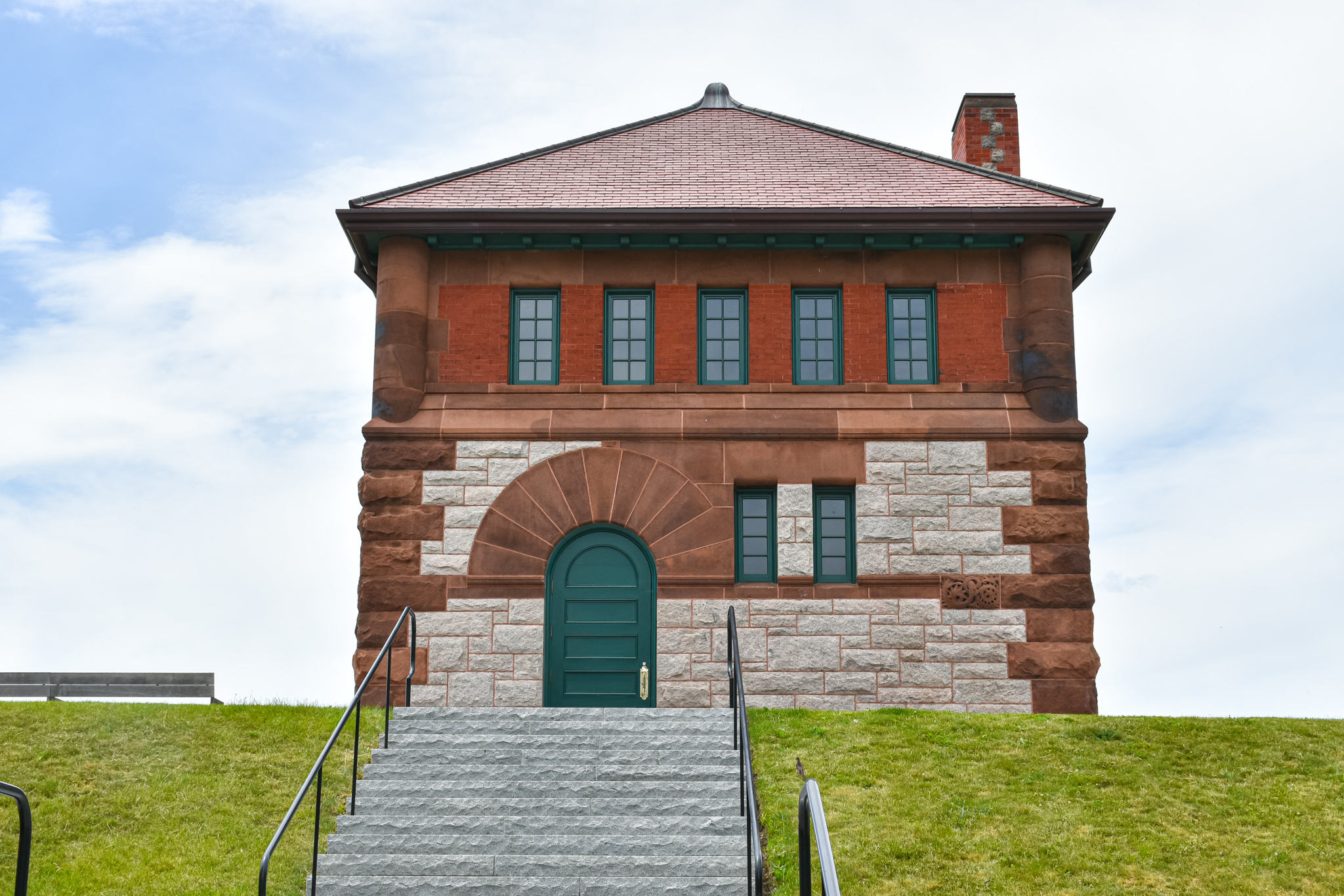
Quite some time ago I was struck by the idea of documenting gatehouses in Greater Boston, and compiling photos and writing about them here. Honestly, though, I'm not sure I'm going to find one that's lovelier than the one on Fisher Hill in Brookline.

Abutting the former Newbury College property, and across Fisher Avenue from a senior living facility under development, the former Fisher Hill Reservoir in 2016 was converted into a 10-acre park featuring an athletic field, a playground, walking paths and a promenade with sitting areas. The reservoir was drained and filled.

Built in 1886-87 under the direction of Boston City Engineer William Jackson, the reservoir and attendant gatehouse, which housed sluice gates, valves and/or pumps to control the flow of water, were eventually incorporated into the metropolitan Boston water system im 1898, according to the Massachusetts Historical Commission.

Built in the Richardsonian Romanesque style, the gatehouse "has a granite substructure, stone main floor, brick second story, and slate hip roof," per the historical commission. "Brownstone is used for quoins and window arches, including the oversized voussoirs above round-arched openings in the main floor. Raised relief terra cotta decorative panels on the building's facade are an instant (sic) of purely decorative detail unusual in the architecture of the Boston and Metropolitan Water Boards."

Lovely to look at, lovely to read about.

(A view of the athletic field.)

The gatehouse was taken out of service in the 1950s and sat unused for decades. In order to turn a long-abandoned gatehouse and reservoir into the fantastic public asset it is today, the City of Brookline turned to Argus Construction Corp. The company cut and removed invasive, unhealthy and dead trees and other vegetation, which comprised the majority of the plant material on site, according to the Brookline Recreation Department.

I still plan to make photos of more gatehouses and write about them here, so stay tuned.

For more Backside coverage of gatehouses, check out:

April 10, 2021, "I Seek Newton, Part X: Newton Centre (Section 3)"

December 5, 2016, "I Seek Newton, Part VI: Chestnut Hill"

Saturday, April 10, 2021

I Seek Newton, Part X: Newton Centre (Section 3)

From Dave Brigham:

I don't have anything flashy to kick off this final installment in my exploration of Newton Centre, so I'm giving you the artsy photo above. That's the doorway into 93 Union Street, which is part of the hulking Bray's Block, which dominates the southern end of the main retail area. In this post, I'll cover retailers, a former factory site, an aqueduct walking path and gatehouses, a squash/tennis club and much more. For links to the previous two Newton Centre posts, and all of the other Newton villages I've written about, see the bottom of this post.

Bray's Block (aka Bray's Hall) is located along Union Street, and was built in 1893 by Mellen Bray, who left a large footprint in Newton during his day, including the Bradford Court apartment building across the street. Upon its construction, this large, curved structure held a bowling alley, an indoor tennis court, a public meeting hall and retail space, according to a Historic Newton brochure. "This is an example of Classical Revival architecture and is especially noted for its many dormers, buff-colored masonry work, and copper clad roof."

There were "concerts, dances or lectures and fairs" on the upper floor, per MACRIS, "while the lower floor offered space for a bank, a grocery, a dry goods store, and a druggest (sic) among others."

Currently, there are numerous stores and restaurants on the ground floor, and office space in the upper floors. There are restaurants in the back of the building, too. Below is the rear of Bray's Block; the letters "P.S." are for Piccadilly Square, which is what this area (including the building across Union Street where Rosenfeld's Bagels is located), was dubbed back in the '70s by developer David Zussman.

Many years ago, I used to frequent the fantastic Mexican restaurant, Cafe Sol Azteca, which is at the rear of this building.

According to the Piccadilly Square web site, the restaurant's location was, prior to the 1970’s, a book binding operation with dirt floors.

In the back lot of Bray's Block is Union Street Restaurant, below.

Located in a stand-alone building behind Bray's Block, this is a great place to eat and drink, and catch live music upstairs. I've seen some cool bands and attended parties up there, and hope to do so again once the lockdown eases. This was where the original heating plant was for the buildings in this area, according to the Piccadilly Square web site.

Abutting Bray's Block is the Union Buildling, which dates to 1896.

Like Bray's Block, the Union Building was built as a combination commercial building and meeting hall. According to MACRIS, upon its completion, the building "contained space for 2 music teachers, a dentist and a photographic parlor." OK, then.

(Close-up of stores on ground floor of the Union Building.)

Just northeast of the Union Building is a one-story building of retail shops dates to 1917.

I love the alleys of Piccadilly Square. One leads to Sol Azteca and another restaurant, House of Tandoor, which serves Indian food. Another alley leads to a Russian eatery.

Cafe St. Petersburg has been in Newton Centre since 2005, after 12 years in its original home in neighboring Brookline. "Cafe St. Petersburg is frequented by artists, writers, musicians, actors, politicians from Russia and around the world. (Co-owner Natan) Slezinger is well-known in Boston community and is also a respected theatre producer in Russia," per the web site. The building dates to 1917. That seems appropriate for a Russian restaurant.

At the corner of Union Street and Langley Road stands Baramor, a gastropub that replaced Terry O'Reilly's, which is what was there when I shot the photo below.

The building dates to 1915.

A stone's throw away, along Beacon Street, is the former Murray's Liquors.

The building dates to 1927/1930, depending on the source. The storefront has been vacant for a few years now. I hope something moves in soon.

Moving west on Beacon Street, we come to the Stuart Building on the corner of Centre Street.

The building dates to 1928, and is currently home to Starbucks, Sandwich Works, a UPS Store, a Coldwell Banker realty outlet and many other businesses.

(Nice remnant from the olden times.)

Heading north from the Stuart Building along Centre Street there are several stores and restaurants in one-story buildings. At the corner of Centre and Pelham streets is Mosher's Men's Store, one of three clothing retailers along this row, including one with a Hollywood connection.

The Mosher's building and others along here date to the 1920s. The men's clothier has been in business since 1921.

(One of many menswear company plaques located on the side of Mosher's.)

Directly across Pelham Street from Mosher's is Alan Bilzerian, which sells both men's and women's clothing, as well as home decor. The company was founded in 1967 in Worcester; today it operates a store in Boston in addition to the Newton one. Next to Bilzerian is Mr. Sid, pictured below.

Established in 1967, Mr. Sid was founded by the grandfather of actor Jason Segel ("Freaks and Geeks," "How I Met Your Mother," "Forgetting Sarah Marshall"). It is still run by his family. The building is known historically as the Garb Drug building.

(Plaque outside Mr. Sid.)

Over on Sumner Street, across from Icon Hair Salon and the post office annex, stands a one-story retail building known as Centre Block.

The building dates to either 1926 (MACRIS) or 1920 (Newton assessor).

I've got two more retail sites I want to cover, and then I'll move along.

This is 552-560 Commonwealth Avenue, which dates to 1917. It is currently home to Atelier 564, an art gallery and framing store; pet grooming business Doggone-It!; a dentist's office and other businesses.

Across Commonwealth Avenue is the building below.

Built in 1916, this building is home to Blacker's Bakeshop, which opened in 2008; Inna's Kitchen, which opened in 2011 and provides catering and to-go meal services; and Mediterranean Grill.

Across Chestnut Terrace from the Atelier 564 building is the Newton Squash and Tennis Club.

Founded in 1902 as the Newton Centre Squash Tennis Club, it is located on property that had been part of the Augustus Hovey Estate (I have no idea who that is.). The original clubhouse has been expanded over the years, as has the number of courts. From the club's web page: "In 1905 the first game [of] Squash Racquets ever played in New England took place at the Newton Centre Squash Tennis Club. Mr. Austin Porter of Wellesley who brought the game from Philadelphia played with Mr. E. Ray Speare of Newton Centre. The game was immediately popular and in a short time had replaced the older game of Squash Tennis."

Newton Centre was never home to large-scale mills or factories, as was Nonantum. Along the eastern fringe of the village, however, there is a former mill site.

Located on Glen Avenue, this building dates to 1985 and is home to Health Equity International and perhaps other companies. A hundred years ago, though, there was something known as Burnham's mill on this site. Internet clues are scarce, but I found in a 1929 Atlas map of Newton a large building on this site, as well as several small ones, including one with what appears to be a smokestack. Charles Burnham is listed as the property owner; I found mention of Burnham's mill at this location in The Newton Graphic of February 1928. I'm not sure when the mill was built or when the business went under.

On the OpenCorporates web site, I found mention of the Old Colony Knitting Mill at this address. The company was in business from 1931 to 1990, per the web site. During at least part of that time, the building was home to Greenfield's Sweaterville, a clothing retailer, from what I've learned via The Newton Graphic of November 1973. The OpenCorporates listing indicates that "Sweaterville USA" was a trademark of the knitting mill.

I'm going to wrap up my Newton Centre series talking about aqueducts and gatehouses.

There are two old aqueducts running underneath the feet of Newton residents: the Cochituate and the Sudbury. The former brought water to Boston from 1848 to 1951, connecting Lake Cochituate in Natick to the Brookline Reservoir along Boylston Street, per Wikipedia. The latter was constructed between 1875-78, running from Framingham's Farm Pond to the Chestnut Hill Reservoir in Newton/Brighton. It was taken out of service in the late '70s and is used as part of a backup system by the Massachusetts Water Resource Authority, per Wikipedia.

There are sections of the old aqueducts that are walkable, featuring not only well-worn paths where you are surrounded by trees, birds, other animals and fellow humans, but also old gatehouses.

This Cochituate Aqueduct gatehouse is located steps away from the Mason-Rice School, as the trail courses through a wooded area behind houses on Chapin Road, on toward the Newton Centre Playground. The aqueduct eventually enters a tunnel at Waban Hill Reservoir.

Just west of the gatehouse, in woodland between Park Lane and Hancock Avenue, you'll come across one of the more whimsical spots in Newton: Jolly's Hollow.

Located on private property between the two aqueducts that prior owners had fenced off from path walkers, Jolly's Hollow is the creation of one Andree Desiree Wilson. "Andrée was the legendary 'gardener (from the sign above) who, during the 50 years she lived there, created this special place. Beginning in the 1990s, as Newton was becoming ever more subdivided, she and (husband) Richard began the extraordinary and arduous process that would eventually donate the Wilson Conservation Area to the city and put all but 0.4 acres of their remaining 1.9-acre parcel under a conservation restriction that protects this legacy in perpetuity," according to this article in the Newton Conservators newsletter. "One important condition of conservation land is that there be public access. Andrée passed away in 2016, and the property will eventually be sold. Now, in a joint effort by the Newton Conservators and the Wilson family, an official path has been created that runs up along the pine-covered hill."

I have walked this path only twice, but feel like I need to back out there to see how it looks with spring upon us.

A short walk from the Cochituate Aqueduct gatehouse pictured above is the Sudbury Aqueduct gatehouse shown below.

Located on Tyler Terrace, abutting the Mason-Rice School, the gatehouse is, like so many of its kind, a beautiful piece of architecture where one isn't necessarily called for. I'm not sure when it was built, but I suppose it was in the 1870s or 1880s.

For more of my explorations of these aqueducts and gatehouse and similar things, see: March 1, 2018, "I Seek Newton, Part VIII: Upper Falls (Section 1)"; June 3, 2016, "I Seek Newton, Part IV: Waban"; and November 11, 2011, "History Flows On, Part I."

That takes care of Newton Centre! Still to come: Newton Corner, West Newton and Newtonville. I have no idea which one I'll tackle next.

Below are the links to all of the previous posts about the villages of Newton.

I Seek Newton, Part X: Newton Centre (Section 2)

I Seek Newton, Part X: Newton Centre (Section 1)

I Seek Newton, Part IX: Nonantum (Section 3)

I Seek Newton, Part IX: Nonantum (Section 2)

I Seek Newton, Part IX: Nonantum (Section 1)

I Seek Newton, Part VIII: Upper Falls (Section 3)

I Seek Newton, Part VIII: Upper Falls (Section 2)

I Seek Newton, Part VIII: Upper Falls (Section 1)

I Seek Newton, Part VII: Thompsonville

I Seek Newton, Part VI: Chestnut Hill

I Seek Newton, Part V: Oak Hill

I Seek Newton, Part IV: Waban

I Seek Newton, Part III: Highlands

I Seek Newton, Part II: Auburndale

I Seek Newton, Part I: Lower Falls

Checking Out Dudley Street in Roxbury...and a Historic, Pre-Civil War House

From Dave Brigham: As part of a series of quick-hit jaunts through Boston this spring, I checked out the outer reaches of Nubian Square, m...