From Dave Brigham:
Named for a 17th century chief of the Nonantum Indian tribe, Waban is one of the least commercialized villages of Newton, Mass. I knew I wasn't going to find graffiti-covered factory walls, abandoned mills or cars rusting in the woods of Waban, one of the toniest zip codes around, but I was confident I'd find something backside-y and worth your visit to this blog.
This is the fourth post in an ongoing series about my adopted hometown. Here are the three prior installments:
May 21, 2015, "I Seek Newton, Part I: Lower Falls"
September 20, 2015, "I Seek Newton, Part II: Auburndale"
March 23, 2016, "I Seek Newton, Part III: Highlands"
Waban's commercial zone is small, but has some cool buildings with good back stories.
Strong's Block, the primary commercial building in Waban, was built in 1896. It was named after William C. Strong, a tree farmer and developer who was instrumental in securing the right of way through Waban for the construction of the Highland Branch of the Boston and Albany Railroad.
(Detail from Strong's Block building)
Now home to a Starbuck's, an ice cream store and a shoe repair shop, the building formerly known as Waban Hall was built in 1890. It once was a school, and also featured small shops before being "renovated." According to the Newton Villages Alliance, the hall was also host to Waban Improvement Society meetings in years past.
(Waban Hall today)
Here's what the hall looked like back in the day.

(Photo from Newton Villages Alliance web site)
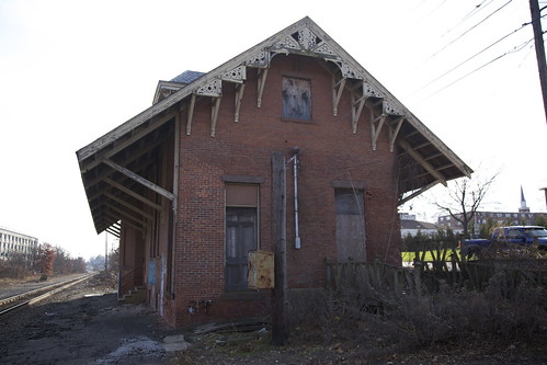
Heading east on Beacon Street, the main thoroughfare in Waban, I came across the former St. Philip Neri Church.
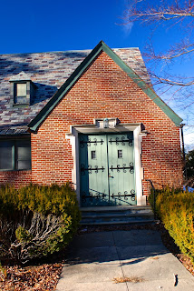
Built in 1930, the building housed a Catholic church for decades, until the Archdiocese of Boston closed it in 2007. A Korean congregation used the building until late 2014, I believe.
A developer has been talking about demolishing the church and building homes here for quite some time. After hearings, discussions with neighbors and at least one return to the drawing board, the developer has scaled the proposed project back from 48 units -- 12 townhouses and a 36-unit apartment building -- to 10-12 apartments and two single-family homes, according to the Newton Tab.
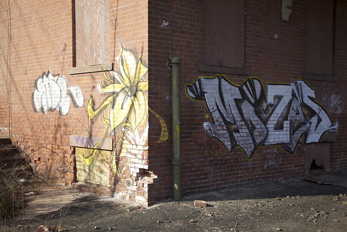
As I said up top, I knew I wouldn't find too much in the way of typical Backside features in Waban, but I was taken aback when I spotted this broken window in the rear of the church.

The church is located on a busy street, near a busy intersection, amid homes assessed at between $750,00 and $2.4 million, just down the street from the Windsor Club, a neighborhood social club whose history dates back a hundred years. Shuttered churches with smashed windows allowing easy access to vandals and adventure seekers aren't featured on realtors' web sites for this area code.
At least the doors seem secure.

While this village doesn't have visible dilapidation or rust, it does have old aqueducts, which I'm quite drawn to (see November 11, 2011, "History Flows On, Part I," and May 18, 2012, "Aqueduct, My Friend").
The Cochituate Aqueduct was built between 1846-48 and conveyed water from Natick's Lake Cochituate through several towns before reaching its final destination, Boston. The aqueduct was taken out of service in 1951, replaced by other systems.
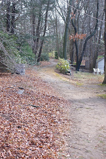
(Path following the course of the old Cochituate Aqueduct, right through the backyards of some very nice homes.)

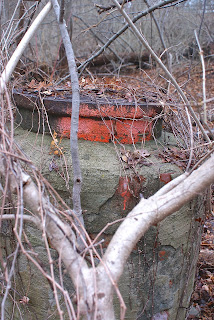
(Stone marker along the aqueduct path. I'm not sure what it indicates; perhaps telephone lines?)

(Locked entry into the aqueduct.)
At what I initially believed was the western fringe of Waban, a nursing home sits where the Woodland Sand & Gravel Co. was once located. After consulting ZipMap online, however, I learned that this site is actually part of Lower Falls. Since I missed this in my previously cited post on Lower Falls, I'll mention it here.

The gravel business comprised approximately nine acres. I have found no other information about the company.
Almost directly across the street from the old sand and gravel site stands this striking building, the former Fire Station 6.
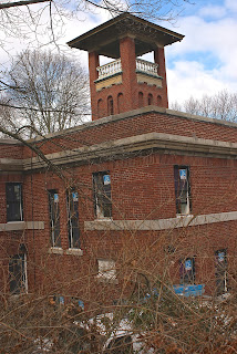
Built in 1917, the firehouse was decommissioned in the late '60s. In subsequent years it was used for a number of purposes, including as a space for a Boy Scout troop and an office for a hospice. More recently, however, this beautiful building was the source of controversy in Waban.
Three years ago, the City of Newton aligned with Pine Street Inn, arguably the most well-known homeless shelter/job training/low-income housing advocate in Boston. The partners agreed to convert the station into permanent housing for nine chronically homeless people and one supervisor. At a meeting in the summer of 2013 held by Pine Street Inn and its partner, Metro West Collaborative Development, however, residents asked many angry questions about what types of people would live there. It was a classic "not in my backyard" scenario, with some well-to-do Wabanites professing to care about homeless people, but having no desire for them to live amongst them.
Long story short: the project was eventually scuttled and now three condos are being developed in the old station. For the whole story, read this excellent Boston Magazine article.
Just behind the fire station sits Neshobe Road, which appears as though it was washed out a long time ago.

There is a road like this close to my home in Newtonville. I take pleasure in the fact that there are broken-down side streets in a city filled with so many busy thoroughfares.
Newton-Wellesley Hospital is in this area of Waban, as well, but ZipMap places it in Lower Falls as well. The Woodland T stop is right on the border with Auburndale, as is the old water tower below.

I love how the tower looms over the parking lot. I always think of "War of the Worlds" when I see towers like this, because some residents of Grover's Mill, New Jersey, who didn't realize the Orson Welles radio play was fictional, mistakenly thought a water tower in their town was an alien invader. I wrote a little more about this tower a few years ago (see June 27, 2011, "War of the Worlds.").
Finally, a trip down by the Charles River.

I love any area where two different environments bump into one another, be it a blue-collar neighborhood rubbing up against million-dollar homes, the ocean lapping on a beach or walking paths along a river. In this latter scenario, I feel a part of history, and I imagine the Native Americans and colonists before me treading these paths looking for fish or game, or engaging in or attempting to avoid a confrontation.
In recent years, a group of Waban and Upper Falls citizens decided to reclaim this area of the Charles, which runs between Routes 9 and 128/95 and looks over at neighboring Wellesley. Calling themselves the Friends of the Quinobequin (so named for the Native American word for the river, and for the roadway that runs alongside at this point), the group clears trash, cuts away harmful vines and maintains a path and short lengths of boardwalk that cross small streams as they head into the river.
This web site features great photos of the wildlife one sees along the trail.
Here's a shot of some type of sewer/drainage structure along the path.
So there's Waban. Keep an eye out for the fifth installment, which will feature Oak Hill, another quiet village that at first seemed like it would present difficulties to this Backside seeker.