From Dave Brigham:
Worcester, Mass., is the second most populous city in New England, and located only about 40 miles from my home outside Boston. It is chock-full of Backside elements of all sorts, from diners to ghost signs to old factories to dive bars to cool neon signs. But until this summer, I'd spent very little time in Wormtown. I probably went to the city in 1983 to see my brother graduate from Clark University, but I have no recollection. In the mid-'80s I went to the city to see U2 at the Centrum (now the DCU Center). In more recent years, I explored Worcester briefly in the early days of this blog and only wrote about an old theater (see June 1, 2012, "We'll Always Have Paris").
I've wanted to return for a long time, and finally made time last August. After that visit, which I chronicle below, I decided I needed to find time to explore more of Worcester. So over the next several months, I will sporadically post about those trips, one of which I've completed as of this writing. This post is the first of three covering my initial trip in summer of 2023.
I chose as my starting point the Canal District area, not far from the relatively new Polar Park, home of the Worcester Red Sox (aka the Woo Sox), the Triple A affiliate of the Boston Red Sox. I chose this area because on my brief drive through the city in 2012, I'd made a few photos there, including the one below.

The building that once housed The Salty Dog Saloon at 1 Kelly Square is now home to a Subway franchise. Known historically as the Vernon Theatre Block, it was built between 1914 and 1916, according to MACRIS. "Upon completion, the Vernon Theatre Block apparently contained several store fronts at street level and a theatre above. After 1922 the theatre ceased operation and the space was rented to the Young Men's Hebrew Association," MACRIS continues.
This area of Worcester, especially along Water Street, was once a heavily Jewish neighborhood. "[I]t wasn’t until the 1880s, when Eastern European Jews immigrated in large numbers to the United States, seeking a haven from pogroms triggered by the assassination of Tsar Alexander II, that Worcester’s Jewish population swelled," according to the web site for Worcester's Congregation Beth Israel. "Many of the new immigrants came from the Pale of Russia — significantly, from what had once been Lithuania — and settled on the city’s East Side, around Water Street. A bustling, tightly-knit Jewish community, Water Street was home to kosher bakeries, butchers, a mikvah (ritual bath), many small businesses, Jewish communal institutions and Hebrew schools. In 1924, there were also eight synagogues on the East Side."
In 1929 the Vernon Theatre Block "was bought by the Polish National Home Association of Worcester for use as meeting halls and club rooms," per MACRIS. "Groups which at the time of its purchase were intending to use the facilities were the Polish Falcons and its drill teams, the Roman Catholic Alliance and the Political Club."
Eventually, as often happens with immigrants, many in the Jewish community moved up to the middle class and left the neighborhood for other parts of Worcester and its suburbs. In the third post in this series, I will feature a mural memorializing a former Jewish deli.
As for the Canal District, it is named for the Blackstone Canal, which ran for 46 miles along the Blackstone River, connecting Worcester to Providence, Rhode Island. The canal was in operation from 1828 to 1848. The Canal District Alliance was formed as a "network for community and business leaders who work together to make the Canal District a neighborhood where people want to play, work, live and invest. This nonprofit volunteer led board of directors is committed to the continual revitalization of the district."
Twenty years ago the City of Worcester commissioned a feasibility study "to assess the potential impact on the City of Worcester and its neighborhoods, and to expose two of Worcester’s most significant natural and historic resources, the Mill Brook and the Blackstone Canal."
Yes, you read that correctly: there has been talk of bringing a small portion of the Blackstone Canal back to life by uncovering the former waterway that is now Harding Street. Check out this video representation to see what it could look like.
Some of the initial buildings in this post are part of the Canal District. From there, I ventured on past Polar Park and onto a section of Main Street.
The first thing that caught my eye on Water Street was part of an old sign for Charlie's Surplus & Athletic Equipment, at #114.

The four-story, brick apartment building rose in 1910. As for Charlie's Surplus, I haven't found out much about the store, other than it was a local institution for many years. I believe the owners, Charlie and Sarah Epstein, were Jewish.
Next door, at 108 Water Street, is Alanwar Market, an ethnic grocery store that also sells a variety of hookahs.

The lovely lady over the door is a relic from a prior business, Wycked Java. As for the low-slung building, it dates to 1910, according to MACRIS, and was once home to Lederman's Bakery & Coffee Bar. Lederman is likely another Jewish name.
Across the street, at 105-111 Water Street, I spied a nice old tile entryway.

This storefront was papered over when I visited; the one next door, at 107, has been home to 107 Tap since early 2023, I believe. The one-story, two-shop building dates to 1920, and was once occupied by Whitman Creamery, as you may have guessed.
Back across the street, at the corner of Water and Harrison streets, is The Broadway, a restaurant/catering/ice cream joint that's been in business since 1946.

Erected in 1910, this place is known historically as the Eisenberg Apartment Building.
At 64 Water Street is the Mendel Block.

Built in 1912, it is a "distinctive example of a brick apartment block with street-level stores; distinguished brickwork; [and a] historical association with a Jewish working-class family as owner," per MACRIS, which mistakenly refers to the building as the "Mandel Block."

This lovely building is currently home to Bombay Lounge. At some point a sports bar called Perfect Game was located here. I'd love to know what the ghost sign is on the side of the Mendel Block.
Next door is The Queen's Cups, a bakery that moved from neighboring Millbury to this former service station.

"Operated as Bob's Filling Station from the time of its construction [in 1936] until as recently as the 1960*s, this building [was later] occupied by a business that [sold] vinyl roofs and convertible tops for automobiles," per MACRIS. "Its original owner, Robert Sack, had run the earlier Sack's Filling Station since the early 1930's. The present building was apparently built both in response to a growing business and to the changing requirements of filling stations. The earlier station was closed after this one opened."
I love this building. It really stands out among so many other classic brick buildings. And I also love when buildings are repurposed for completely different uses than originally intended.
At the northern end of Water Street, where it meets Winter Street, is a former factory that's been turned into apartments.

Now known as Canal Lofts, this circa-1890 complex was built for the W.H. Hill Company, which manufactured envelopes. In 1897, Hill "became one of several Worcester envelope companies which were merged into the newly formed U.S. Envelope Company," according to MACRIS. "As late as 1970, the firm remained in this building."
At the intersection of Winter and Grafton streets, in the shadow of I-290, is a former long-standing business that shut down operations recently.
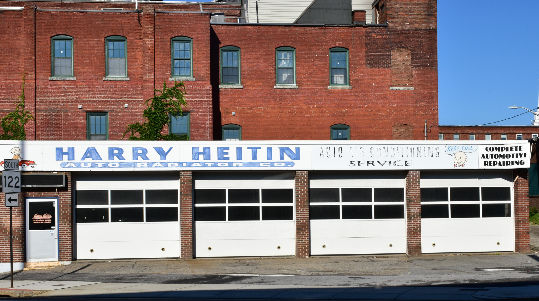
Harry Heitin Auto Radiator was in business for 70 years before the owner sold the lot to a restaurant chain in August 2022, according to an article I found online from the Worcester Telegram & Gazette.

Given that this area is close to Polar Park and filled with new apartments and bars, restaurants and other newish businesses, I wasn't surprised to see another former stalwart that has gone under after decades in business.

Fairway Beef, which was located just steps away from the radiator joint along Grafton Street, "abruptly closed its doors" in July 2021, according to this Patch article. "Fairway Beef was opened in the Canal District in 1946 by the Sigel family — who are still the owners today," the Patch article indicated at the time. "The store sold all types of meat cuts, plus staples like bread, eggs and deli cheese."
In September 2022, a developer appeared before Worcester's zoning board of appeals looking to demolish the Fairway buildings, with an eye toward redeveloping the site as a nine-story housing and commercial building, according to the Worcester Telegram & Gazette. I'm not sure of the status of that proposal.
Next door to Fairway Beef is the MB Lounge.

MB calls itself "the oldest gay owned & operated bar/lounge in Worcester" on its web site.
At this point, I took a quick detour under the highway overpass to check out an old industrial area.

Tucked just east of I-290 between Franklin, Plastic and Grafton streets, the former Merrill & Usher Company complex, with its light-brick buildings, presents a different look than most industrial sites I come across. Founded in 1922 as Everett F. Merrill Company, the outfit grew to be one of the largest steel and aluminum supply businesses in New England, according to Wikipedia.

In September 2013, the city's planning board cleared the way for potential redevelopment of this site by removing one of the side streets from the official city map, as the roadway is private. The developer, DOK Realty sought to have the street removed from the official map so the street could be included within the scope of the development area, according to this Worcester Telegram & Gazette article. On my quick trip through here, I saw no evidence of any redevelopment.
I believe at least some of the buildings here date to around 1910. Merrill & Usher filed for dissolution in 1984. I hope to explore more of this area on a future visit.
I headed west on Franklin Street, thought briefly about checking out Union Station, but opted instead to head back toward Polar Park. At the corner of Franklin and Harding streets, I spied a few ghost signs -- one for a company that still exists, although not at this location, and another for a long-gone business.

The top sign is for a factory once operated by Charles Meiselman, according to what little I've found online. The lower sign is for Goldstein Scrap Metal, which is now located on Kansas Street.

I made a third photo of this building, from the rear, but there were a few homeless people setting up tarps and I didn't to upset them so I shot quickly and moved on.
Steps away, heading south on Harding Street, I saw a sign that I'd shot the last time I was in Worcester all those years ago. Making a photo of it this time around rewarded me with a two-fer, as there is a historic marker in front of it.

Samuel Heywood began manufacturing shoes in Worcester in 1864, according to MACRIS. S.R. Heywood & Co. made shoes here until 1941, and maintained an outlet here until 1961. I realized after the fact, while doing online research, that there is a much larger ghost sign on the facade of this building that faces Winter Street (as seen on this Fading Ad Blog post, which also shows the former Buckley's Store building featured in the historic marker in my photo).
Buckley's Store rose on this corner in 1870, along what at that point was the Blackstone Canal. The building served as a store and dwelling until the 1920s, according to the sign. In the 1940s Samuel Gaffin operated Gaffin Paper and Scale Company and Gaffin Refrigeration Company here, according to MACRIS. In more recent years, the building served "as a storage place for items salvaged from the trash."
The building appears in a Google Street View image (below) from August 2007, but has a white "X" on a red background on it, which indicates it was unsafe for habitation. I'm not sure when it was torn down.
I continued south, and then southwest along Harding Street, past the Worcester Ice Center and came across yet more ghost signs.

I haven't been able to figure out what this sign, located on the north-facing wall, advertised. Below is a sign on the south-facing facade for Wolf White & Son, which operated a dry goods store.

These two signs are located on the backside of the Bombay Lounge building mentioned above.
At the intersection of Harrison and Green streets is an amazing building with a great past.

The photo above shows the rear of what is currently the White Eagle Polish Club. "In 1937, The White Eagle was established as a Polish membership club," according to the group's web site. "It was established not only in the heart of the Polish neighborhood in Worcester, MA, but also the heart of the canal district."

Built in 1888, this Victorian Eclectic beauty started life as -- wait for it, because it's so damn good -- Father Matthew's Total Abstinence Society Hall. For real!

The date "1849" appears near the roof line. This is the year "an Irish priest, Rev. Theobald Matthew, visited the city while touring the United States," according to MACRIS. "Preaching against the evils of drink, he pledged 400 Worcester Irishmen to total abstinence. A few weeks later, some of these men formed the Father Matthew Total Abstinence Society."

(Side entrance to the club.)
The temperance society remained at least somewhat active until around 1930, per MACRIS.
Across Pond Street from the White Eagle, I spied a groovy mural.

Located on the back wall of Blackstone Herbs & Martini Bar, this work of art was completed by Guitars n Gang Signs, and features The Hulk and other superheroes.
Looking up Gold Street toward Polar Park, I spied a cool little guy I needed to check out.

According to this Mass Live article, the "large bobblehead" depicts "the title flailer" from "Casey at the Bat: A Ballad of the Republic, Sung in the Year 1888," a "mock-heroic poem" written by one-time Worcester resident Ernest Thayer and first published in 1888 in The San Francisco Examiner, according to Wikipedia.
The park, by the way, looks great.
After a brief stop by a new Worcester institution, I strolled past the ghost of an old one.


Table Talk Pies is still in business, don't worry. But the company is no longer located in this building along Green Street (although there is a pie store further north along the street), but rather on Gardner Street. Founded in Worcester in 1924, today the company employs more than three hundred people, baking in excess of 250 million pies a year at three automated bakeries, according to the company's web site.
Located due south of Polar Park, the former Table Talk site is under redevelopment, as you can see on the back of the building below.

"In total, Boston Capital has announced plans to build about 400 units on the old Table Talk site, including a forthcoming 317-unit building," according to this February 2023 article from the Patch. "The developer Quarterra is also planning a 375-unit building nearby on the site of the former Smokestack Urban Barbecue restaurant."
From the old pie-making site I headed west-northwest along Madison Street, past the Woo Sox park, under the train tracks and Francis J. McGrath Boulevard and straight into an Instagram-ready backdrop.

Located on the rear of the Guertin Graphics (offering screenprinting and custom t-shirts since 1968) building, this sign lured me into a set of buildings that were cool enough from the back, but which had me giggling with delight when I saw the fronts.

I love the brashness of the building color and the bold sign for Union Music, which has been in business since 1900. I'll include more details below.
Next door, I was pleasantly shocked by an even more amazing rear facade.

"Coney Island Hot Dogs?!" I said to myself. "Where the hell am I?"
The great contrast between the mustard-yellow building and the deep-blue food truck prepared me just a little bit for the front of this legendary joint.


I don't come across sites like this very often on my treks around Massachusetts. The light wasn't great, but I made a bunch of photos and just marveled that such a place exists.
George's Coney Island was opened in 1918 by Catherine and George Tsagarelis. "In 1938 they renovated the restaurant in the utilitarian art deco style that it boasts today," per the company's web site. As for the sign featuring a hand holding a weiner dripping with mustard: "George Tsagarelis died in 1980, and the famous Coney Island sign remains as a reminder of his legacy. The iconic neon sign was his idea. He held up a dog and someone took a picture. Then the sign was modeled after it."
Even the side of the building is great.

Next door, Union Music is much more understated, but still has some great signs.


Founded in 1900 on Front Street as a pawnshop called Union Loan Co. Inc., the business changed over to a music shop in 1973, according to an article on the Union Music web site republished from Worcester magazine. In 2018, the Barabash family took over ownership.
Next door to the music store is a building that I'm guessing may get torn down in the not-too-distant future.


Built in 1870, this Second Empire building originally had two storefronts at ground level and a boarding house above, per MACRIS. Two additional storefronts were added around 1890. It was most recently occupied by A-1 Wholesale Window & Siding Co. Prior to that it was home to Cornerstone Paint & Wallpaper. I'm not sure whether the upper floors remained residential, not am I sure what is to become of this place.
A short walk up Madison Street and I was in front of a building the likes of which I haven't seen before.


The Classical Revival Worcester Market Building rose in 1914, and "was believed to be the largest grocery supply store in the United States at the time of its opening," according to MACRIS. "[A]t the peak of its success the store handled the business of 25,000 customers 'in an ordinary Saturday's trade.' In addition to the main market hall and warehouses, the building housed a bakery (with 20 bakers), a shipping department (with 110 workers), a carpenter shop, an electrical shop, and a kitchen to prepare foods for its delicatessen."

"Upon completion, the building contained a variety of labor-saving innovations," MACRIS continues. "The first floor (of 25,000 square feet) served as the market, while the second floor and basement were used largely as warehouse space (50,000 square feet total). Storage was arranged so that goods for different departments were stored directly above or below their respective departments, connections to which were provided by elevators, thereby protecting customers from having 'to watch out for heavily laden trucks hurrying in with fresh supplies.'"
Nowadays, this space is occupied by the Arca Adult Day Health Center.
From the market, I swung left onto Main Street and spied the Aurora Apartments.

This beauty was built in 1897 as the Hotel Aurora. These days, the building consists of several studio apartments.
A little bit west on Main Street is a former Odd Fellows building that has been converted to loft apartments.

From MACRIS, a lovely descripton of the architecture: "Designed by Clellan Fisher of Worcester...the I.O.O.F. Building is an opulent example of Beaux Arts Classicism, a popular style of the early twentieth century. The building's facade (east) is faced with brick laid up in a Flemish bond and trimmed with dressed limestone. Three bays wide, the facade is symmetrical, rising from a low basement to a rusticated first storey (sic). Centered on the first storey (sic) is an elaborate limestone entry with a pediment (decorated by a shield) set on consoles with garlands. On either side of the entry at the second storey (sic) are stone balconies with original iron railings."
The final stop on this first part of the tour is another former fraternal organization building. Well, just a small detail from it.

Built in 1926 as the meeting hall for the Worcester Aerie of the Fraternal Order of Eagles, the building at 701 Main Street (MACRIS says it was previously #695) is currently home to the Ebenezer Church. When it was built, there were "two floors of ceremonial and meeting places above stores on the street level, including a huge, two-story, wood-paneled auditorium that filled the rear half of the building," per MACRIS.
The "L.T.J.E." inscribed below the eagle in the above photo stands for Liberty, Truth, Justice, Equality, and is the motto of the Fraternal Order of Eagles.
The Worcester FOE chapter is now located on Norfolk Street.
From this point I cut south along Hermon Street because it looked promising. Make sure to check out the second part of my first Worcester adventure to see what I found.


