Showing posts with label carriage house. Show all posts

Saturday, November 7, 2026

Way Down Yonder in Pawtucket, Part II

From Dave Brigham:

I ended my first post about Pawtucket by discussing a metal sculpture of Rev. William Blackstone, who is considered Rhode Island's first permanent English settler (see October 23, 2026, "Way Down Yonder in Pawtucket, Part I"). This second installment begins with a photo I made while crossing the river named for the minister, along the Morris Nathanson Bridge.

This is the former George H. Fuller & Son factory building. Located at 151 Exchange Street, the mill was once a hub for making parts for jewelry, including clasps and hooks, according to a Valley Breeze article I found online. According to the City of Pawtucket web site, the city has 300 diversified industries, with the three largest being jewelry and silverware, metals and textiles. I mentioned a few former jewelry makers in the first Pawtucket post.

The Fuller building dates to the 1880s. In 2020, the Pawtucket Planning Commission approved a revised plan by a developer to revitalize the old mill. The plan called for converting the building to 22 apartments. While other old mill buildings in this neighborhood have been switched over to residential or commercial use, I'm uncertain whether the Fuller plan has been put into effect.

Across Exchange Court from the old Fuller factory is another former industrial site that's been beautifully restored. I only shot the rear of the building, because I love the contrast between the old and new.

Known as the Design Exchange, this four-story brick building was previously part of the Rhode Island Cardboard Company complex constructed in 1880, per the web site for LLB Architects, the firm behind the redesign. The building was so named "for its focus on attracting creative enterprises," the web site continues. The architecture firm has its office in the building.

Across Exchange Street is the former Pawtucket Armory.

Completed in 1895, the armory is "composed of two distinct sections: a 3 1/2-story, rectangular main block facing Exchange Street, and a 140-foot by 80-foot gable-roofed drill hall which stretches along Fountain Street," per Art in Ruins. For decades, this place was witness to all sorts of, you know, armory-related stuff. From 2005 to 2010, after a renovation, the armory housed the Jacqueline M. Walsh School for the Performing and Visual Arts. It is currently home to the Pawtucket Armory Arts Center.

The armory's eastern neighbor is the one-time home of the John W. Little Co., a label and printing business founded in the early 1900s.

The building dates to 1914. Screen printing and embroidery company Mirror Image is now located here.

Around the corner, heading north on Broadway, is Division Brakes, part of a small local chain in business since 1984.

The building dates to 1917. I love the look of the building and the sign.

From here, I headed southwest on Broadway, where I was quite taken by the look of #139.

This funky building was once the carriage house for the Metcalf Mansion, which was built in 1880 next door and burned down a century later. The mansion was built for Henry B. Metcalf, a Boston-born politician and businessman "who served as the Prohibition Party's gubernatorial candidate thrice and vice presidential nominee in 1900," per Wikipedia.

Metcalf "helped to form the Boston Button Company as the firm's senior partner and in 1874 he moved to Rhode Island where he established the Pawtucket Haircloth Company," Wikipedia continues. "He later formed the Campbell Machine Company in Boston which made machinery to make shoes. He later served as a Trustee of Tufts College and also as President of the Trustees of Tufts College." He died in 1904.

In more recent years, a storefront was added to the carriage house. I'm not sure whether this is a residence or a business at this point.

While I often focus on buildings from the late-19th and early-20th centuries, and signs and business dating back many decades, every once in a while my attention is captured by something a bit more modern...and quite confusing.

As I bopped along Broadway, past a stately old church to my left and while enjoying the view across a park of the Blackstone River and downtown Pawtucket, I couldn't help steering my eyes up and to the left.

What the hell am I looking at? I wondered.

Does Pawtucket have an ancient pyramid? A modern megachurch? Or perhaps the ruins of an homage to the Eiffel Tower?

No, no and no. This is what's left of the former Apex Department Store. Developed in the late 1960s on a site that was once several dense urban blocks, the store featured a ziggurat -- a lofty pyramidal structure built in successive stages -- with the name Apex emblazoned on the front. Backing up to Interstate 95, the store had a large parking lot and was in business here until sometime in the early 2000s.

In 2004, the Division of Motor Vehicles, Pawtucket branch, moved into half of the Apex space and stayed there until 2010, per Art in Ruins. Apex still owned the property, and the company's CEO announced a redevelopment plan shortly after the DMV vacated the site. A restaurant, Cresta Bar & Ristorante, moved in 2011 and closed in 2015. No other tenants were located here, as far as I've found.

In 2018, the Boston Red Sox Triple-A affiliate in Pawtucket considered building a new stadium on this site. But that didn't happen. The City of Pawtucket acquired the site in 2021. In August 2026, several proposals to redevelop the site were published by the Providence Journal.

Let's return to that enjoyable view across the Blackstone River from where I shot my first Apex photo.

The buildings in the distance make up Slater Mill, which in 1793 became the first successful water-powered cotton spinning mill in the United States and the first property to be added to the National Register of Historic Places, in November 1966, according to the National Park Service's web site for the complex.

Moses Brown formed a company where machines could spin cotton fiber into thread, but he needed better equipment. "In December 1789, Brown hired Samuel Slater, a recent immigrant from England," per the NPS write-up. "Slater had spent the past seven years working in an English textile mill. He rose from an apprentice to an overseer of machinery and mill construction. Slater determined that Brown’s existing machines would not work. New machines that could card (brush) and spin the cotton would need to be made locally. For several years, Slater worked with local mechanics, like members of the Wilkinson Family, to make new machines. In December 1790, Slater got the machines running. For the first time, workers could produce thread on water powered machines in America.

"In 1793 the firm of Almy, Brown and Slater replaced their experimental workshop with a new mill," seen in the photo above.

I walked a bit more before looping back to Main Street, across from Still on Main, which I wrote about in the first Pawtucket post. On the corner of Main and Maple streets stands the former Pacific National Bank Building, which dates to 1890.

I liked the juxtaposition between the CHECKS CASHED awning and the H&G PROFESSIONAL BUILDING clock.

At this point I made what I eventually realized was an unwise decision: to continue walking in the early-summer heat in search of a diner that I knew I had to see. If I'd really thought about it, and taken into account the fact that I'd already been wandering through Pawtucket for probably 90 minutes and my feet were tired, I would've driven. Nevertheless, I eventually got to the eatery, and found some other cool spots on my way there, and then on my return to the center of the city.

After a bit of aimless wandering, I ended up heading south on Pine Street, over I-95 and then east on Delany Street, where I came across the abandoned St. Mary's School.

Once part of the sprawling St. Mary's Church of the Immaculate Conception complex along Pine and Grace streets, the school shuttered in 2009 due to low enrollment and high costs of maintaining the building. A developer acquired the building at some point, along with a neighboring convent that was part of the parish. While the convent has been converted to condos, the school still sits empty.

The school was built in 1891. St. Mary's was the first Catholic parish in Pawtucket, and the second in Rhode Island, launching in 1830. The church ceased operations in early 2026.

I hit George Street and headed east-southeast until I connected to East Avenue, walked a short distance and gazed upon the Modern Diner.

Old mill towns used to have loads of diners, and many of these are still standing, if not always in business. So I seek them out and am always quite happy when I see one that's still slinging hash, and looking good while doing it.

"The Modern Diner is known for both its diner classics and its variety of ever-changing breakfast specials," per the eatery's web site. "The Pawtucket restaurant was chosen to be the first diner in the nation to be accepted on the National Register for Historic Places. Customized and factory-built, it is a Sterling Streamliner, a line of 'modernistic' diners manufactured in the late 1930’s and early 1940’s."

The diner "is one of the few known surviving Sterling Streamliner diner still in operation," per Wikipedia. "Its profile resembles that of a 1934 silver locomotive that once pulled the streamlined Burlington Zephyr train."

I believe the diner traded hands last year or this year, after the Demou family had owned it for nearly three decades. The diner's original location was 13 Dexter Street in Pawtucket, not far from the 125 Lofts complex I mentioned in the first post about this Rhode Island city.

While standing across the street from the diner, admiring it in all its glory, I looked down at the sidewalk and got excited. I'm sure anyone eating hash and eggs in the diner who happened to look out my way would've thought to themselves, "What the hell is that nut taking a picture of?"

Well, Mr. or Mrs. Diner Eater, here's what:

I've stumbled across other medallions like this one, in Newton and Winthrop, Massachusetts, that I can recall. The Works Progress Administration (WPA) was a New Deal agency that operated in the 1930s and 1940s, employing millions of job seekers (mostly men) to carry out public works projects, such as the construction of public buildings and roads. The WPA installed and repaired sidewalks in cities across America, including Pawtucket. I love that nearly 90 years later, this badge still looks great.

At this point, I started heading north, back toward downtown and my car. A short distance from the Modern Diner, I liked the look of High Motor Bar & Grille, especially the old stadium seats out front.

The place is evidently fairly new, as Google Street View from 2022 shows this place as Craft Burgers & Beer. In 2007, it was the East Avenue Cafe; in 2011, Doherty's East Avenue Irish Pub. The pub space fills the ground floor, while apartments appear to occupy the upper two floors. As for the four seats out front, I believe they came from the demolished McCoy Stadium, where the Pawtucket Red Sox played.

Continuing north on East Avenue, I dug the clean lines of Downeast Coffee Roasters.

Founded in 1953, the company is run by second and third generation family members.

Near the end of East Avenue I was charmed by an adorable brick commercial building.

The building dates to around 1920, from what I've learned online. For many years, this quaint space was home to Ferdie's Key Shop. If you zoom in on the photo, you may be able to see "EST. 1932" above the door. I think that was the date the key shop opened. Ferdie's closed in 2015; at the end of that year, Bob Parmentier, owner of AA Locksmith in neighboring Central Falls purchased his former competition, according to this Valley Breeze article.

Parmentier and his son-in-law, Josh Cournoyer, ran both key shop locations at that point. I'm guessing the shop wasn't open for all that long, as by 2022, according to Google Street View, this property was occupied by Petit Bakery. The June 2025 Street View shows a sign up for the bakery. As you can see, there's no sign now. The last Facebook post for the bakery was made on February 15, 2024. So I'm not sure what business is here now, although there was an OPEN sign hanging when I made this photo.

Steps away, at the corner of East Avenue and Grace Street, facing I-95, is the awesomely named Mr. USA 1 Hour Cleaner.

Per the dry cleaner's web site, the business has been owned and operated by the Leonard family since 1947. "You've invested a lot of thought and care into your wardrobe," the web site says. "Shouldn't you choose a reliable dry cleaner you can depend on?"

Yes you should.

I headed north across the highway along George Street and Park Place, scanning for any other cool sites before I got to my car. I intersected with Main Street, hung a left and and a quick right on to North Union Street. I loved the painted facades along the rear of what is known these days as the McDevitt Building.

Originally known as Kinyon's Block, this building in 1888 was "constructed in the Queen Anne style, with a 4-story corner tower," according to Art in Ruins. "[T]he top floor of the tower was removed and the remaining tower walls were clad in concrete in 1923 during an Art Deco-style remodeling, which also introduced opaque colored spandrel glass at the 2nd floor level of the tower (above the comer storefront at #9), a concrete door surround at the Broad Street entrance to the upper floors (#23), and added the name 'McDevitt Building' to the top of the tower and over the Broad Street main entrance."

Check out the photos in that post, as they show how beautiful the building was at the turn of last century.

Early building tenants included the YMCA, Kinyon's Commercial School (run by the building owner's son, Hervey Kinyon) and an upholstering business run by Charles Rittmann, this latter fact according to this history of the State of Rhode Island.

By 1915 the W.H. McDevitt clothing store had moved into the storefront at #25, and as of 1921 the building was re-named McDevitt’s Block, per Art in Ruins. Today, tenants include Legendary Barber Shop and In Your Skin Studio, an "adult pole & dance studio."

I continued northeast on North Union Street, across Summer Street, until I was looking at the rear of the former Feldman Furniture building that I mentioned in the first Pawtucket post.

Finally, I love a mural, as you all know. This one on the facade of the Comprehensive Community Action Program building at the corner of North Union and High streets.

CCAP is one of the largest community action programs in Rhode Island, per its web site. The organization provides family medicine and dental care; behavior health services ad substance abuse counseling; Head Start and child care; family development services; social services, WIC nutrition program; a food bank; and home heating and energy assistance.

I haven't been able to find out who painted that mural.

That's it for Pawtucket! I hope to explore more of the Ocean State in the future.

Saturday, November 11, 2023

In Which I Learn About West Medford's Slave Wall and a Related Estate

From Dave Brigham:

Having spent a bit of time in West Medford Square (see October 14, 2023, "I Went to West Medford Square by Mistake...But That's OK"), I was searching Google Maps for more sites to explore in that neck of the Massachusetts woods, when I stumbled across "The Cistern," which I wrote about recently (see November 4, 2023, "Cisterns Are Going It for Themselves"). Less than a mile away from that place on Lower Mystic Lake is the other map pin that intrigued me: Pomp's Wall.

I find a fair amount of cool historic stuff using this method. Located on Grove Street, across the commuter rail tracks from Playstead Park, Pomp's Wall is one of the few relics of Medford's slaveholding past. Built by a slave named Pomp (aka Pompeii or Pompey) in 1765, it is also known as The Slave Wall.

The inscription on the plaque reads, in part that Pomp, "a slave owned by Thomas Brooks" built the wall "as part of a decorative entrance to his house. This site was part of the estate of the Brooks family, which was first occupied in 1679 and once included some 400 acres of land."

A restoration of the wall was completed earlier this year, according to the Medford Historical Commmission. "The wall is laid in Flemish Bond, a decorative brick pattern that can now be seen clearly. Much of the wall is original 18th century brick and the mason [did] everything he [could] to preserve the hand made features....The bricks were stored to document their exact location so the wall [could be] rebuilt exactly as it was."

The Brooks family farmed their land and may have also owned a mill. MACRIS provides details about the wall and the family that owned Pomp, collected from a genealogy in the collection of the Medford Brooks Estate Land Trust Archives. "The Brooks family were large landowners in Medford beginning in the late 17th century. In 1660 Thomas Brooks...with his son-in-law Timothy Wheeler purchased 400 acres east of the Mystic Lake and River in Medford for £404....According to this genealogy, subdivisions of this land passed to several subsequent generations of the family, including Thomas’ grandson Samuel Brooks (1700-1768) and great grandson Thomas Brooks (1732-1799)."

"The park behind the Slave Wall was donated to the City of Medford in 1924 by the Brooks family," according to the plaque. Thomas Brooks Park is shown in the two photos below.

A fieldstone wall along the property line was also restored.

More from the wall plaque: "By 1765 Medford’s population included 49 slaves, many of whom were tied to the infamous Triangle Trade. Only Boston and Cambridge had larger slave populations. Nonetheless, Medford was an early center of anti-slavery activity. In 1783 Massachusetts became the first state to abolish slavery. Today the Slave Wall and the Slave Quarters at the Royall House are the only remaining physical reminders of slavery in the city. When Slaves were freed, many settled in West Medford which is today considered among the oldest continuous African-American communities in the United States."

Less than a mile north along Grove Street is the Shepherd Brooks Estate, which features a gorgeous Queen Anne-style home situated on expansive grounds adjacent to Oak Grove Cemetery. The large brick home was commissioned in 1880 by a descendant of the slaveholding Brooks family.

I was excited to learn that the estate grounds are free to roam, so I could get some great photos of the outside of the house, which was designed by Peabody and Stearns the well-known Boston architectural firm of the late 19th and early 20th century.

From MACRIS: "The Shepherd Brooks House is among the most architecturally distinguished late nineteenth-century 'summer residences' extant in Medford and the only estate to survive with extensive acreage of undevelopped land. Sheherd Brooks (1838-1922) lived in Medford during the summers from 1880 to 1922; during the rest of the year he resided at 90 Beacon Street in Boston. Brooks graduated from Harvard in 1857 and pursued throughout his life an interest in farming and horticulture for which his West Medford estate was well known along the East coast."

The home and carriage house are not open to visitors, as far as I can tell. The property, which is owned by the City of Medford, has been undergoing restoration with an eye toward "continued community benefit," per the estate's web site.

I hope you enjoyed this post. I'm always excited to learn about connections to the shameful parts of American history.

Saturday, February 26, 2022

Jamaica Plain, Part II: The Return

From Dave Brigham:

I had such a good time shopping for Christmas presents and taking photos along Jamaica Plain's Centre Street (see January 22, 2022, "Jamaica Plain, Part I: Shopping & Snapping"), that I decided three times in the ensuing weeks to continue my tour north along the main drag and into Hyde Square. The latter neighborhood is known as Boston's Latin Quarter, and I found numerous Latinx-owned businesses and several cool murals reflecting the culture of immigrants who have made their mark on the area. There are other cultures represented in this area, of course, from an Irish bar to restaurants serving Ethiopian and Chinese food.

This rusted sign says, "JAMAICA PLAIN" above a cornucopia of food, and HYDE JACKSON SQUARE MAIN STREET below the bounty. As you can see, this sign has seen better days. It's an anachronism, as in 2019 the group changed its name to Three Squares Main Street, to reflect its focus on a business district that encompasses Hyde, Jackson and Canary squares. I didn't make it as far east as Jackson Square. Maybe someday soon. As for Canary Square, as you'll see below, it's a postage stamp-sized neighborhood.

I love that Streetcar Wine & Beer took its name from the trolleys that once rolled down Centre Street. The sign over the entrance was done by Best Dressed Signs.

From the 1850s, when the West Roxbury Railroad laid tracks in this area, through horse-drawn railcars and electric street cars and into the mid-1980s, Jamaica Plain was well-served with public transit. In 1985, however, the Massachusetts Bay Transportation Authority (MBTA), temporarily closed what was then called the Arborway Line, for repairs and renovation. In the ensuing years, JP residents battled the state for return of the streetcar line, but, long story short, the service was never started up again. Tracks through Centre Street were dug up or paved over in the early part of this century. Buses now run along the route. To read the whole story, check out this excellent Jamaica Plain Historical Society web page.

(Cool mural on the side of Streetcar Wine & Beer, which was also done by Best Dressed Signs.)

I love how murals are seemingly everwhere in Boston and and its surrounding towns and cities. Many of them have been in place for years, and been retouched and updated over time, as you'll see below. Others are newer, livening up the sides of otherwise drab buildings. As I've mentioned before, Boston has an official mural crew run out of the mayor's office, giving kids and teens the chance to help brighten their neighborhoods while also providing links to history and important causes.

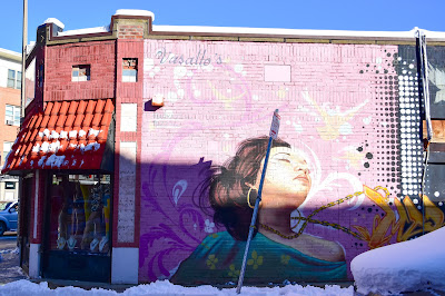
On the side of a CVS in Canary Square, I spied the work below.

(Detail from the painting.)

Oftentimes I find it fairly easy to find out through an online search who painted a given mural. With this one, however, I am stumped.

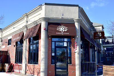
Across Moraine Street from this work of art is Canary Square, which calls itself an American restaurant and bar.

The eatery and the small square around it are named after "William Canary, a Jamaica Plain resident who served in the 101st Infantry Division, who bravely and valiantly lost his life at St. Mihiel, France, September 12th, 1918," according to Canary Square's web site.

At Canary Square, Centre Street heads northeast and eventually east, and South Huntington Avenue heads due north. Walking north on Centre, I looked to the west, down Barbara Street, and noticed a funky building that I had to check out on South Huntington.

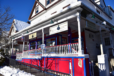
This is the former stable of what is known historically as the Andreas Tomfohrde House. Built in 1897, the stable was designed by William Holmes and built by John McNamara & Sons, according to MACRIS. The house was converted to a funeral home in 1946; today it is the Mann & Rodgers Funeral Home. I'm not sure whether the stable is an office or a residence. As someone commented when I posted this photo on Instagram, "Take off that siding!"

Back on Centre Street I spied the Mosaic Boston Church.

The congregation "is a brand new church in Boston," per its web site. "We are a Christian church with a deep love for God, the Bible, and the city." Erected in 1904, this building is known historically as the First German Baptist Church. Most recently, River of Life Church was located in the building.

On the other side of Centre Street is the Whole Foods building, which dates to 1965.

Formerly home to a Hi-Lo Supermarket, this building stands out amid the low-slung retail and restaurant buildings and three-decker apartment houses in the area. Do we call the wavy roofline and stylized sun clock mid-century modern? I don't know, but I like it. Historical side note: at this address once stood the Jamaica Theatre, which was designed by Clarence Blackall. It was demolished in the 1960s.

Across Centre Street from the grocery store, I dug these two doors, situated between Cuban restaurant El Oriental de Cuba and the Jamaica Plain Laundry Centre.

On the rear wall of Whole Foods is a massive and amazing mural.

Painted in 1984 by Rafael Rivera Garcia, a New York-born artist of Puerto Rican descent, this work of art "depicts figures from the mythology of the Taino, the indigenous people of much of the Caribbean including Puerto Rico," according to this Vamonde web page. The mural was restored by the Mayor’s Mural Crew in 2003.

(Detail of the mural.)

Next door is The Haven, which offers "Scottish food, drink and great banter," per its web site.

The bar is located in the same building (but not the exact spot, I don't think) where the legendary Bella Luna/Milky Way Italian restaurant/nightclub/bowling alley complex was founded in 1993.

Bella Luna/Milky Way closed in June 2020, due to, you guessed it, inability to function during the times of COVID. The eatery and enterainment business -- they offered karaoke and dance parties -- moved to the Hafenreffer brewery complex in 2008 (for more about the old brewer, see, "Artist Thinks: 'I HAF to Fix That Smokestack'"). I only went to the Milky Way once, to see local band Honeyglazed. Their two-bass, male-female singing duo approach was pretty sexy and danceable.

Across Perkins Street from The Haven is a groovy painted electrical box.

Supposed to look like a Rubik's cube, I guess. I love the trend of letting artists loose on painting electrical boxes.

Across the little rotary where Centre, Perkins and Day streets say hello to each other, in front of the office of Mark W. Miller, Esquire, is a well-inked former public phone.

Hanging above it is a defaced sign that now reads, "Mr one PEACE WITH NORTH KOREA."

Continuing along the south side of Centre Street, we come to a local institution.

Opened in 1989, the Brendan Behan Pub is one of the few traditional Irish pubs left in Boston. When I moved to Boston in 1990, places like this were everywhere I went, from Allston to Brighton to downtown to Jamaica Plain and everywhere I didn't go. The pub (no kitchen) is named for Irish poet/novelist/playwright/short story writer Brendan Behan, who wrote in both English and Irish. Behan was active in the Irish Republican Army and served time in prison for attempted murder.

A few doors down is an impressive apartment building with retail on the ground floor, clad in green vinyl siding.

Unfortunately, La Casa de Los Regalos (House of Gifts) is no longer open. The building dates to 1935.

One door down, embedded in the storefront for Jamaica Plain Wellness is something that I missed on my first swing through this neighborhood, so I'm really glad I happened upon it when I returned.

Let's break this down: "B" denotes "Boston." "4" indicates the number of miles from this location to the First Town House in Boston, where the Old State House stands today on Court Street. "1735" is the date the stone was placed along Centre Street. "PD" indicates Paul Dudley. This is one of several mile marker stones that Dudley, an attorney general for the Province of Massachusetts and chief justice of the Superior Court, erected (or, more likely, had someone do for him) along various routes. I have seen other ones in Newton, Brookline and Boston's Allston neighborhood over the years.

What's so cool about walking through an old city like Boston is seeing old bump up against new, Colonial cultural touchstones side-by-side with businesses run by newer immigrants. In Hyde Square, there are many small, locally owned businesses amid the few chain outlets. The building below dates to 1900, per the Boston assessing department. In addition to Centre Fashion, a women's clothing store that caters to the local Latinx population, other tenants include Mr V, which sells auto accessories; Caribbean Consultant, Inc.; and Fernandez Travel Agency.

On the side of this building are three fantastic murals painted by Victor “Marka27” Quinonez

I was battling the sun and shadows, as you can see. I wish I'd gotten better photos.

On the north side of Centre Street, in front of the former Blessed Sacrament Church, which I featured in March 2015, is a lovely Little Free Library.

Continuing east, but back on the south side, we come to the Lucy Parsons Center, "an independent, non-profit, radical bookstore and community space." Note the graffiti that says, "ALL COPS ARE DEREK CHAUVIN," the officer convicted of murdering George Floyd.

From Wikipedia: "The Red Book Store (now the Lucy Parsons Center) began in 1969 in a small one-room basement shop in Central Square, Cambridge. It moved two or three times in the first couple of years, before settling into what would be its home until 1983 in a large space on the corner of River and Pleasant streets in Cambridge. In 1983 the project moved to Jamaica Plain....It stayed there until May 1994, returning to Central Square, where it stayed four years until it was evicted so the building could be demolished. In May 1998 it moved into a temporary space in Davis Square, Somerville. Davis Square was a temporary location and with sales suffering, the center was flooded and had to make an appeal for support. In 1999, the project moved to the South End of Boston and finally moved back to Jamaica Plain in 2011.

"The center's namesake, Lucy Parsons, was a radical labor organizer and anarchocommunist in Chicago from the 1880s onwards....One of the original founders [of the bookstore] was professor and activist George Katsiaficas. Initially Maoist, the bookshop was run by an anarchist collective until the late 2010s and is currently operated by a multi-tendency revolutionary collective."

There you go.

Another corner, another fantastic work of public art.

Painted on the side of Pimentel Market, the mural was commissioned by the store's owner, Luis Guerrero. There are actually four girls in the mural, but I couldn't get a good photo that includes them all.

A block away is the United Baptist Church, which is also home to Iglesia Amor y Gracia Boston.

The building dates to 1899.

Next to the church is Mozart Park, which features a playground, a basketball court and some nice murals.

There is also a stunning sculpture, called "Reach," which "symbolizes the immigrant experience of reaching up to climb the ladder of success in America," according to the park's web site.

The work was completed by artist Douglas Kornfeld, who has installed sculptures all around the globe.

In between the park and the church is a groovy, painted electrical box.

Continuing east along Centre, on the north side of the street is a newer strip mall, featuring a Dunkin' shop, a T-Mobile store, a Bank of America branch, a dentist office and other businesses. Behind that L-shaped building is a Stop & Shop grocery store. On the south side of Centre, however, is the kind of urban mish-mash that is what makes cities great, although plenty of folks find this cheek-by-jowl style of architecture ugly (See: the destruction of Boston's West End back in the 1960s.).

On the left is Freddy's Market, which offers "Productos Latinos," in addition to ice cream, vegetables, groceries and lottery tickets. On the right is Latino Restaurant, which, judging by the style of sign and the lack of an area code on it, has been around for quite some time. And judging by the outsized lobster claws on the sign, I guess this place specializes in seafood.

The building dates to 1930 and, as you can see, also features apartments behind and above the storefronts. This is such a classic American city concept, but one that is increasingly being demolished and turned into shinier places catering to people with more money. Two doors down, past a dry cleaners, is Young Kong Restaurant.

The building dates to 1940. I'm guessing there have been many types of restaurants here over the years. Again, what's great about this strip of Centre Street is the mix of types of ethnic foods and the mom-and-pop attitude to the businesses.

Now I'm gonna hop over to the north side of Centre Street and work my way back toward the west. Just past the aforementioned strip mall is Fellowship Church of God.

I absolutely love the trio of signs out front. So much nice than the typical drab greeting most churches offer. The building dates to 1899, and was once home to St. Andrew's Methodist/Episcopal Church, I believe.

A block away, on the corner of Centre and Gay Head streets, is a nice old house with storefronts on the first floor, including Fernandez Beauty & Barber Shop.

This place dates to 1920. I'm curious about how Gay Head Street got its name. From 1870 to 1997, Gay Head was the name of a town on Martha's Vineyard. In 1997, after a town vote, the name was changed to Aquinnah, a Wampanoag word that means "land under the hill," per Wikipedia. I suppose whoever developed the street just liked the name, or had some connection to the Vineyard.

Next is another representation of what makes this area great: Yolanny Salon; La Nacional, a place where locals can receive money from overseas or send it to relatives back home; an apartment house; and, most curiously, Radio Tropicalisimo de la Tarde.

I gather that the radio program, which is available on Watertown, Mass.-based WRCA, broadcasts in Spanish beginning at 3:00. The station is owned by Beasley Media Group, and carries financial news from Bloomberg Radio, along with local news, traffic and weather reports. Founded in 1948 as WCRB, the radio station began as a Waltham-based community station. Over the years, it has served as classical music station, a big band outlet, an easy listening channel, a home for country music and more. It has leased time to ethnic broadcasters since 1991, according to Wikipedia.

Up next is The Old Havana restaurant, which has been around since 2013.

The building dates to 1930. I'm not sure if it's always been a restaurant space.

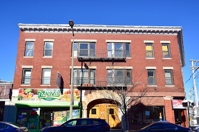
When I saw the building below, with its beautiful, arched entryway, I guess that perhaps it was once a police station.

I've searched and searched, however, and found no details whatsoever about this place, other than that it was built in 1910. Retail tenants include Captain Nemo's Subs & Pizza and Tropical Market.

The final two places on this tour are located at the small rotary where Perkins, Centre and Day streets meeet.

The Blue Nile restaurant specializes in Ethiopian cuisine. I'm not sure how long the eatery has been here.

After posting so many photos of cool JP street art, it seems appropriate to end this two-part series with yet another awesome mural on the side of a business that is unfortunately defunct.

Located on the side of the former Beauty Master salon, this work of art is another by Victor "Marka27" Quinonez.

I hope you've enjoyed this trek through Jamaica Plain as much as I did (three times!). I hope to check out other parts of JP in the near future, especially some of the old brewery complexes. Stay tuned!

Way Down Yonder in Pawtucket, Part II

From Dave Brigham: I ended my first post about Pawtucket by discussing a metal sculpture of Rev. William Blackstone, who is considered Rho...