From Dave Brigham:
UPDATE: Although I just published this post a few days ago, I have a brief update. Many of the photos below are several months old, as is some of the information. I was in Kendall Square briefly today and was shocked to see how much construction has taken place right around the subway stop in the half year since my initial visit. So I just wanted to let you know that I realize my information and pictures aren't as up to date as I'd like, but otherwise I think I've given a pretty good idea of what changes have come to the neighborhood, and are still on their way. Thanks! -- DB
First, your headline explainer: Urban Dictionary: L7.
You can't swing a slide rule in Kendall Square without hitting a biotech nerd, start-up incubator boss, Facebook algorithm specialist or an expert in turning turnips into a luscious foam that costs as much as an Uber ride from Cambridge to Silicon Valley. Still, there are reasons for lovers of the backside of America to stroll through this bustling and quickly changing neighborhood of Cambridge, Mass.
I spent some time last year spread across two trips checking out Kendall Square, as well as a bit of the area west of the square (because it was such a nice day). Be prepared to spend some quality time on this post; there are LOADS of pictures and information, which is why it's taken me several months to finish this post. As I hope you've noticed, I've been digging deep on a lot of projects lately, from the neighborhood around the soon-to-open Encore Boston Harbor casino (see May 4, 2019, "Roll the Dice: Encore!"), to the old shoe manufacturing town of Marlborough (see May 19, 2019, "Marlborough Melange") and the rail trail and environs in Weston (see March 24, 2019, "Weston By Musket and Sextant").
First, a little history about the square, courtesy of Wikipedia:
"Originally a salt marsh on the Charles River between Boston and Cambridge, Kendall Square has been an important transportation hub since the construction of the West Boston Bridge in 1793, which provided the first direct wagon route between the two settlements. By 1810, the Broad Canal had been dug, which would connect with a system of smaller canals in this East Cambridge seaport area." For a look at what little remains of this canal system, see November 5, 2012, "Where's the Gondolier?"
More from Wikipedia: "The area became a major industrial center in the 19th century, and by the beginning of the 20th century was home to distilleries, electric power plants, soap and hosiery factories."
By 1965, NASA was eyeing Kendall Square as a major hub of operations.
"When President John F. Kennedy made his bold claim that the United States would be the first nation on the Moon, he maneuvered to have several of the area's older industrial manufacturing and other dirty businesses removed by eminent domain. Kennedy's idea was to make Kendall Square the headquarters for the NASA mission control center." After JFK died, President Lyndon B. Johnson moved the NASA project to Houston.
Eventually, former Massachusetts Governor John A. Volpe, "succeeded in getting the former NASA buildings rededicated to a new DOT research center, which was later named the John A. Volpe National Transportation Systems Center in his memory. For the next twenty years, other large parcels of Kendall Square, which had also been cleared in anticipation of a much larger NASA complex, were an unoccupied post-industrial wasteland."
That's not to say that there wasn't redevelopment going on in the square. In 1980, construction began on the Cambridge Center complex, which grew to include several buildings, some of which house a Marriott hotel, a Legal Seafoods restaurant and companies of all sorts, sizes and shapes. New buildings and rents continue to rise across the square, as old structures are torn down and the neighborhood transforms into a leader of the 21st century technology industry.
Alright, strap yourselves in and let's see what's what in Kendall Square.

"So," you're saying to yourself, "Dave writes this long, involved lead-in about high-tech and rising rents and hipsters, and he starts off with a church?" True, this isn't my typical subject, but I love churches and also am fascinated by the Mormons. That's due to the whole "I found gold plates buried in the ground that I translated into the Book of Mormon, then I gave the plates back to Moroni, an angel, and nobody else has ever seen them" thing espoused by founder Joseph Smith. Here's their house of worship on Binney Street. Built in 2009.
Alright, let's get to the true backside stuff.

This is 161 First Street, home to biotech firm Finch Therapeutics Group. Erected in 1907, the building was formerly home to Lotus Development, a software company founded in 1982. Originally this building was home to the Ashton Valve Company, which merged with Boston-based Crosby Steam & Gage, whose building I featured in "Where Am I? Somertown? Charlesville?" from March 16, 2019. The First Street property is being redeveloped by Alexandria Real Estate Equities, which has its fingers in many Kendall Square pies.

(They done tore the back part of 161 First Street clean off!)

This is 41 Linskey Way, another Alexandria R.E. project. Like 161 First Street profiled above, 41 Linskey began its long, illustrious career as a building in 1907. The site started life as home to the New England Maple Syrup Company. In 1917, the property was purchased by Crew Levick Company, which used the property as an oil and grease storage facility, according to this 2015 U.S. Department of Environmental Protection document. In the ensuing years, the property was owned by a refining corporation. It was turned into offices in the early '80s.

(A closer look at 41 Linskey Way. Want to see what it will look like after it gets redeveloped? No, I don't think you do.)

This is the building that sparked my interest in documenting the backside of Kendall Square, when I drove by it coming home from the nearby CambridgeSide Mall. Kendall Boiler and Tank Co. is a going concern, which is awesome. The company isn't located at this site anymore; it's in Chelmsford, Mass. The complex of buildings was restored and converted into office space by PRA Architects.

(Close-up of the former Kendall Boiler building.)

The building in the above photo was renovated as part of the construction of the corporate headquarters of Biogen, Inc., which develops and manufactures drugs for those living with serious neurological, autoimmune and rare diseases, per the company web site. You can see the new building rising behind this old one.

I'm not sure what this building was in its original incarnation. To get a look at it before it was restored, check out this link.
Around the corner from Biogen, on Bent Street, is the back of the Foundry Building. If, like me, you aren't sure exactly what a foundry is, here's our answer: "A foundry is a factory that produces metal castings," per Wikipedia. "Metals are cast into shapes by melting them into a liquid, pouring the metal into a mold, and removing the mold material after the metal has solidified as it cools."

Built in 1890, the foundry once "processed up to 50 tons of iron per day," according to the web site of the Cambridge Redevelopment Authority, which owns the building and is redeveloping it into a center for art, entrepreneurship, technology and workforce education. The foundry "was originally part of a larger industrial complex for the Blake & Knowles Steam Pump Company. The complex, including the Foundry, was once a nationally recognized manufacturing facility and supplied 90% of pump supplies to the U.S. Navy in the 1930s. In the 1960s and 1970s, the building was used as a taxi barn," according to the CRA web site.
Just up the street from the foundry I spied this house and garage.


I really like the look of each of these buildings, for different reasons. The house looks like it could have been a library at one point; the garage looks like it could have a time machine inside, built by some eccentric M.I.T. professor who disappeared without a trace many years ago, perhaps to return as a post-Trump savior. With all the development in this area, I wonder whether either of these structures will be here in five years.
And now for some buildings that are modern and boring and ugly, but just as mysterious as the garage above.

Located along Bent Street, this is where AT&T stores the Internet. Or maybe this is the graveyard for all of the world's old rotary phones. Or perhaps this hulking monolith is stuffed with Russian spies tapping into your each and every phone call and computer keyboard click.

And right across the street is where Verizon spies on AT&T.
At its western end, Bent Street intersects with Fulkerson Street. That's where I found the old Metropolitan Pipe & Supply Co. complex.


Metropolitan was at this location along Fulkerson and Binney streets for 50 years before moving to a new location in neighboring Somerville. The aforementioned Alexandria Real Estate Equities bought part of this property in March 2017 for $80.25 million, and plans to develop new office or laboratory space here. The other portion of this property was acquired by Cabot, Cabot & Forbes, which plans to develop a residential building at that location along Fulkerson.


I continued a little further west, to Cardinal Medeiros Avenue, named for the former Archbishop of Boston. Where that roadway intersects with Hampshire Street sits One Kendall Square (photo below), an eight-acre complex that includes office, lab, restaurant and cinema space. It is owned by -- you guessed it -- Alexandria Real Estate Equities, which acquired the property in July 2016 in a blockbuster $725 million deal, one of the largest transactions ever in the Boston office building market.

Formerly the base of operations for the Boston Woven Hose and Rubber Company, the set of buildings is now home to Cambridge Brewing Company, the Friendly Toast, the Smoke Shop and other popular eateries and businesses.
One restaurant that has moved on was formerly located cater-cornered (or catty-corner or kitty-cornered; I'm using the original, because I just learned it) from One Kendall. Emma's Pizza (below) was at this spot on Hampshire Street for 16 years; the pizzeria was in business at other locations in Greater Boston for 54 years before shuttering in 2016. The restaurant has a take-out spot in Boston, I believe.

I haven't been able to determine what the fate of this property is, but I can almost guarantee that the former Emma's and the small building and parking lot next to it will get redeveloped.
Across Portland Street from the former Emma's, and directly across from One Kendall I found some cool stuff.

On the back wall of Advance Tire Company there is this amazing mural. I'm not sure whether the company, which has been family owned and operated since 1914, has always been at this spot. Known as The Port Story, the mural was created by David Fichter, who has painted other massive and beautiful works all around the Boston area. This mural showcases figures from this neighborhood, known as The Port (formerly Area 4), including women's rights advocate Margaret Fuller, civil rights activist Clement Morgan, abolitionist William Lloyd Garrison and Elias Howe, inventor of the sewing machine. The mural also features everyday citizens, as well as shout-outs to the nut maker Squirrel Brand Co., cracker manufacturer Thurston, Hall & Co., soap maker Curtis Davis & Co., and the Kimball and Davenport Omnibus, among other historic local businesses.

Next door to the tire store, in the triangle formed by Hampshire and Portland streets and Broadway Avenue, is a Cambridge Electric Light substation.

I'm guessing the other building on the site (below) was also once an electric light structure.

Just up Broadway, heading east, is a fantastic vintage clothing store, the legendary Garment District.

Above is my artsy picture of the "alternative department store."


I also strolled down Davis Street and took a few more of the side and back of the building, which was built in 1893. "Until World War II, the building housed soap manufacturer Lysander Kemp & Sons," per the Garment District web site. "In the postwar years, the building was occupied by several businesses, including the Cambridge Printing Co, a bronze foundry, and Harbor Textile Waste Co." It was this last business that birthed the funky clothing retailer. "The Garment District opened in 1986 as an off-shoot of [the] textile company....which manufactured and sold wiping cloths and gloves to a variety of industries."
At this point I ventured beyond the boundaries of Kendall Square, further into The Port, formerly known as Area 4. This zone is bounded roughly by Central and Inman squares, as well as M.I.T. Starting from the western edge of my journey, I'll work my way back toward Kendall Square.

I know, my photo of this building makes it look like it belongs on the old TV series "Batman," which regularly featured crooked shots of crooks. Located on Massachusetts Avenue between Central Square and M.I.T., this is the global headquarters of drug maker Novartis. It is located in a former factory of the New England Confectionary Company (Necco), one-time maker of Necco Wafers, Sky Bars, Mary Janes, Sweethearts and other candies (see January 5, 2019, "There Was No Way-fer Necco to Carry On").
Directly across from the Novartis building is 211 Massachusetts Avenue, which is owned by M.I.T. but was included in a major project by the drug company to add lab and communal space.

Built in 1904, this building just looks important and I wish I'd taken a better photo of it. I'm not sure what its original purpose was, but at some point it was a laundry building for the university, according to one source online. More important to world interest, though, is this building's history as the one-time home for Whirlwind, the world's first general-purpose digital computer.
"During World War II, the U.S. Navy approached MIT about the possibility of creating a computer to drive a flight simulator for training bomber crews," per Wikipedia. "The Servomechanisms Lab in MIT building 32 conducted a short survey that concluded such a system was possible."
From this unusual building with a fascinating history, I scooted down Village Street, heading toward State Street, when I saw these cool murals on the side and back of the Naco Taco building.


Along State Street, just as I spied the side of this monochromatic building....

....I got a faint whiff of candy, and I remembered that I was standing next to the local branch of Cambridge Brands.

Cambridge Brands is a subsidiary of Tootsie Roll Industries, a candy maker that dates to 1896. This building was once the home to the James O. Welch Company, creator of Sugar Babies, Sugar Daddies, Sugar Mamas and Junior Mints, among others. That company was once one of dozens of candy manufacturers in the city; Cambridge Brands is the last sugar-coated soldier standing.
This place isn't much to look at on the outside, and while just about anyone who learns that this nondescript building is home to a candy manufacturer imagines Willy Wonka's factory, the truth turns out to be disappointing. "[I]t was just a bland factory run by a small team of Central American women in hair nets," according to a person quoted in this 2018 Boston Globe article. "The Cambridge Brands facility is the world’s only source of Junior Mints, Sugar Babies, and Charleston Chews — but it doesn’t make Tootsie Rolls or Tootsie Pops," per the Globe article.
Next door to the candy factory is 750 Main Street (below, the backside), which is owned by M.I.T. Built in 1910, the place is listed as being in "poor" condition by the City of Cambridge on its online property database. I'm not sure what, if anything, goes on in here. I'm guessing it will be redeveloped before too long.

Continuing east along Main Street, across Osborne Street from the random M.I.T. building above, I found a couple of cool plaques memorializing two technology industry titans.

"From his workplace in this building, Edwin H. Land (1909-1991) led the Polaroid Corporation in its development of the first instant photography system," this plaque begins. Polaroid still exists today, even though it no longer dominates the instant photography market like it once did.

Mere feet away from the Edwin Land plaque is this one recognizing the immeasurable impact that Alexander Graham Bell had on the world. "From this site on October 9, 1876, the first two-way long distance conversation was carried on for three hours. From here in Cambridgeport, Thomas G. Watson spoke over a telegraph wire to Alexander Graham Bell at the office of the Walworth Mfg. Co., 69 Kilby Street, Boston, Mass."
It's pretty cool that two iconic inventions were hatched in the same building, decades apart. Prior to serving as the birthplace to telephones and instant cameras, this site was home to the Kimball & Davenport company, which produced train cars (see above photo of the mural on the back of Advance Tire to get an idea of their product).
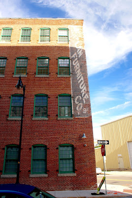
"So what sorts of tech innovations are going on in this building today?" I'm happy you asked. This building is now home to LabCentral, which calls itself a biotech innovation hub. "It offers fully permitted laboratory and office space for as many as 60 startups comprising approximately 200 scientists and entrepreneurs," per its web site. "A private, nonprofit institution, LabCentral was funded in part by two $5 million grants from the Massachusetts Life Sciences Center, with support from its real-estate partner, MIT."

Isn't it beautiful? I love when old buildings are rehabbed and improved upon, rather than simply being torn down.

In addition to technological wonders, this building was, at some point, home to a furniture company, as you can see on these ghost signs.

Continuing my trek eastward, I spied this funny place.


Look closely: that's a faux exterior at 620 Main St., a warehouse dating to 1908 owned by M.I.T. Why did the tech institute hire someone to create a fake front for this building? Perhaps the place looked really crappy and the school wanted to dress it up while deciding what sort of gigantic gleaming-glass behemoth to build in its place. I don't know. Maybe it was one of those famous M.I.T. hacks. Anyway, I found one source online that indicates this was a Polaroid building at one point. I also found a listing online from the Cambridge Historical Commission that indicates that prior to Polaroid, the building's owner was Squirrel Brands, a nut maker founded in Boston that moved to Cambridge and now exists in Elgin, Ill.

I can't quite make out what the ghost sign on the side of the old nut company building is for. Next to this building is an even larger warehouse (below) that is part of the same storage complex.

A short walk east heading back toward the heart of Kendall Square I got this cool view.

This is the M.I.T. Department of Brain and Cognitive Sciences, with train tracks running underneath. The tracks split off the railbed for east-west Amtrak/MBTA commuter train service near the Massachusetts Turnpike in Boston's Allston neighborhood, and run through Cambridge and all the way under Route 28 in Somerville, where they connect to north-south Amtrak/commuter lines that run out of Boston's North Station. The tracks are known as the Grand Junction Railroad, and date to 1847. The right-of-way is used primarily to transfer equipment between lines. At one time, the Barnum & Bailey Circus used these tracks to park cars when the show was in Boston.
Further along, near the Kendall Square subway station, is this beautiful building.

This is the Kendall Hotel, the front lobby of which is located in the former Engine 7 firehouse.

With all the construction going on amid so many shiny, new buildings, I was shocked to see a vacant lot that didn't appear to have anything going for it. This site for years was owned by the Constellation Charitable Foundation, which had hoped to build a performing arts venue on this site. Last August, however, the foundation sold the property to BioMed Realty for more than $50 million. BioMed owns several properties in Kendall Square and elsewhere in Cambridge, Watertown and Boston. The company also operates in high-tech hot spots including Seattle, San Francisco, New York and San Diego. I haven't been able to find any information about what the developer plans to put up here, but I'm guessing it will be large and shiny.
Directly across the street from this site is a nice park that in the winter is used for community ice skating. I'm guessing this little garage is used to store supplies and snacks for those events and others.

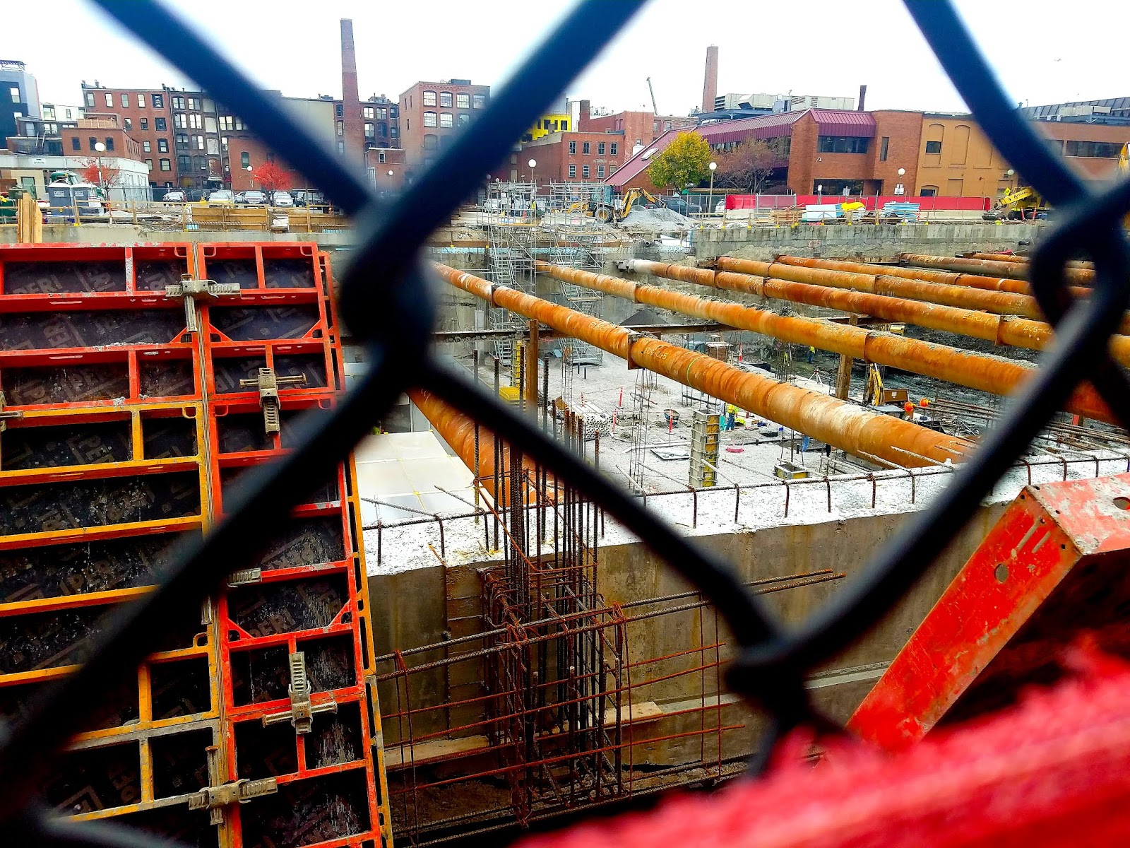
Whew! We're almost done. The penultimate stop on this tour is another hole in the ground.

OK, so this is a shot of a few buildings, but if you were to swan dive off that lovely clock tower, you'd land in a big construction pit. Well, you would have back in October when I took this shot. This is the backside, natch, of the Kendall Building, located at the corner of Hayward and Main streets, just past an entrance to the Kendall MBTA station, as you approach the Charles River and the Longfellow Bridge. Built in 1905, the Kendall Building currently houses a post office, a bakery, a flower shop, a bank and other businesses. Amid the construction going on around it and directly behind it, the Kendall Building will remain largely as it is now.
"The Kendall Building is a five-story brick building containing 69,219 GSF of office space that will be retained in the proposed project in addition to 12,781 GSF of retail that will be repositioned," according to the special permit application submitted by M.I.T. in 2015. "Building 3 will be an addition to the rear of the Kendall Building totaling approximately 280,000 GSF of research, laboratory and technical office space (R&D) use and approximately 27,000 GSF of new and repositioned retail and active uses," the application continues.
Last, but certainly not least, is 139 Main Street, which was built in 1874, and most recently housed the Massachusetts branch of the Red Cross.

You won't be shocked to learn that M.I.T. owns this property, which was known at its construction as the Luke Building, as it was home to E.H. Luke & Sons, dealers in grain, meal, hay, straw, according to this web site (scroll down for a nice old picture of the building) from the architecture and design firm, Arrowstreet. The adaptive re-use project included "re-enforcing the building’s foundations and reconstructing the southeast corner facades due to serious settlement imperiling the foundations and brick walls," per Arrowstreet. "The team meticulously restored the masonry, original fenestration, stone trim details, and the historic carriageway (originally for hay wagons) that provided a connection through to the canal behind."
Man, I really wish every project in and around Boston could be like this one. OK, well maybe not each and every one. But I would love to see more classic old buildings renovated in their entirety, not just the facade (see April 6, 2019, "UPDATE: Cashing Out (And Learning About Facadism").
OK, that's a wrap. I wish I'd explored Kendall Square years ago, before there were so many glass-walled high rises. The good news is that even amid all the changes occurring in and around Boston, I can still find pockets of the backside.