From Dave Brigham:
There are several great sites referenced in the right-hand column of this blog -- Backside's Beloved Blogs. While many of them don't change much, if at all, they all offer really cool photos and commentary of the lesser-seen parts of this great country (except for the few music- and general-interest blogs listed there). As for the ones that do update on a regular basis, I have to admit that I don't check them out often enough.
I've had Shaun O'Boyle's Portraits of Place site linked for quite some time, and have enjoyed looking through his numerous excellent galleries. Just recently, though, I decided to check out his affiliated blog. And boy, what a trip!
The majority of the pictures (as of this writing) are black and white. Most of the gorgeous shots fit into the Backside aesthetic, but even the ones that don't, such as the Appalachian Trail and Saratoga race track pictures, have that oh-so-pleasing historical feel.
I hope you like them as much as I do.
Saturday, November 26, 2011
Sunday, November 20, 2011
History Flows On, Part II
From Dave Brigham:
Recently, I posted about two old aqueducts in Newton, MA (see November 11, 2011, "History Flows On, Part I"). Now I present the second installment in a three-part series that gives a little insight into the history of Greater Boston's water works.
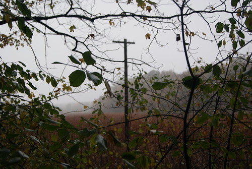
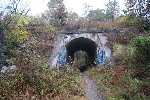
I knew little about Cutler Park before recently crashing through its woods in a light rain. I thought I'd spend about an hour there, see most of the park, including the tunnel under the commuter train tracks, then run a few errands and head home for a shower before picking up my daughter at preschool.
This place, it turns out, is massive and has quite a history.
Spanning the towns of Newton, Needham, Dedham and Brookline, and the West Roxbury neighborhood of Boston, Cutler Park is comprised of somewhere between 700 and 800 acres, and is the largest remaining fresh water marsh on the middle Charles River, according to the Newton Conservators web site.
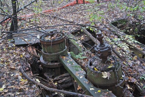
The marshlands, according to the conservators, was created by flooding from the Newton Upper Falls Silk Dam, and were used for pasturelands for hundreds of years. In the late 1800s, the marshes were used as watershed well sites, which explains the remains of filtering ponds, ditches and waterworks.
As I've said in previous posts, I love stumbling upon this type of stuff in the woods, and realizing how much the landscape changes in a relatively short time. If I'd wandered these same acres perhaps half a century ago, I would've seen working pump houses and electrical wires strung along the ponds, and been able to do so without any of the noise that nearby Route 128 now provides.
A century ago, I would've seen train tracks that were used to transport soil taken from the west side of the pond to fill in the Back Bay section of Boston in the 19th century. According to Wikipedia, some of the old tracks are visible near the north entrance to the park, but I didn't notice them. I definitely plan on revisiting the park, so I'll look for the tracks.
Stay tuned for the third, and final, part in this series.
Recently, I posted about two old aqueducts in Newton, MA (see November 11, 2011, "History Flows On, Part I"). Now I present the second installment in a three-part series that gives a little insight into the history of Greater Boston's water works.
I knew little about Cutler Park before recently crashing through its woods in a light rain. I thought I'd spend about an hour there, see most of the park, including the tunnel under the commuter train tracks, then run a few errands and head home for a shower before picking up my daughter at preschool.
This place, it turns out, is massive and has quite a history.
Spanning the towns of Newton, Needham, Dedham and Brookline, and the West Roxbury neighborhood of Boston, Cutler Park is comprised of somewhere between 700 and 800 acres, and is the largest remaining fresh water marsh on the middle Charles River, according to the Newton Conservators web site.
The marshlands, according to the conservators, was created by flooding from the Newton Upper Falls Silk Dam, and were used for pasturelands for hundreds of years. In the late 1800s, the marshes were used as watershed well sites, which explains the remains of filtering ponds, ditches and waterworks.
As I've said in previous posts, I love stumbling upon this type of stuff in the woods, and realizing how much the landscape changes in a relatively short time. If I'd wandered these same acres perhaps half a century ago, I would've seen working pump houses and electrical wires strung along the ponds, and been able to do so without any of the noise that nearby Route 128 now provides.
A century ago, I would've seen train tracks that were used to transport soil taken from the west side of the pond to fill in the Back Bay section of Boston in the 19th century. According to Wikipedia, some of the old tracks are visible near the north entrance to the park, but I didn't notice them. I definitely plan on revisiting the park, so I'll look for the tracks.
Stay tuned for the third, and final, part in this series.
Friday, November 11, 2011
History Flows On, Part I
From Dave Brigham:
Honestly, I could keep this site going simply by posting about the out-of-the-way places I find in and around my adopted hometown of Newton, MA. But if I changed the blog's title to "The Backside of Newton," people might think I was consumed with Sir Isaac, or Juice or Fig.
So I'll keep things the way they are, but the content I post here is going to remain skewed toward Eastern Massachusetts, 'cause I don't get around much.
As with many things in Newton and surrounding towns that I've posted about before (see June 27, 2011, "War of the Worlds," and May 19, 2010, "Nuclear Dump Playground?"), the aqueducts that are the subject of today's piece are things I've driven past countless times and wondered about.
There are two of them: the Cochituate and the Sudbury. The Cochituate was built between 1846-48 and conveyed water from Natick's Lake Cochituate through several towns before reaching its final destination, Boston. The aqueduct was taken out of service in 1951, replaced by other systems.
The Sudbury was constructed between 1875-78 and brought water from Framingham to Boston. It, too, was taken out of service many years ago, replaced by three other delivery systems. However, in May 2010, the Sudbury was put into emergency use when the Weston Aqueduct suffered a major rupture. The Sudbury remains part of the Massachusetts Water Resources Authority's (MWRA) emergency backup service (thanks, Wikipedia!).
For that reason, I shouldn't have been surprised when two MWRA workers questioned why I was taking pictures of visible remnants of the aqueduct. I assured them I was only interested in the history of the water system. I told them I ran a web site featuring abandoned factories and old bridges, and that satisfied them enough to point out the Cochituate aqueduct, which at certain points in Newton runs adjacent to the Sudbury.
One of the things I love about living in and traveling around New England is that I'm surrounded by the past. Just off a main drag running north to south through Newton, you find this pleasant entrance to the Sudbury Aqueduct:
After disappearing underground for about half a mile, the aqueduct reappears in the spot where I encountered the MWRA workers. This picture was the one they seemed most concerned about.
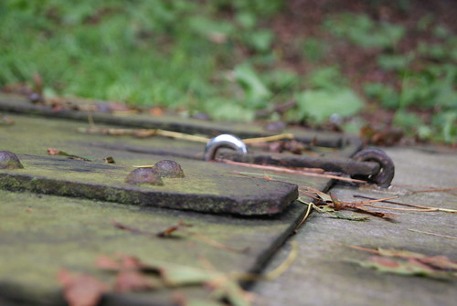
Pop the lock off this old hatch and you'd be able to lower yourself into the aqueduct. Obviously, the MWRA is concerned about somebody accessing the water supply and poisoning it. I guess I have an honest face. Or perhaps they took down my license plate and are shadowing my every move.
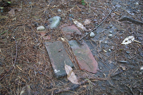
As I said, they were nice enough to direct me across the street to the trail that follows the old Cochituate Aqueduct. I don't know for sure that the waterway was made from bricks, but I'm guessing it was based on this picture.
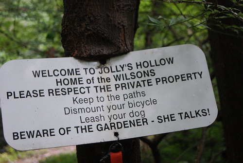
The trail continues on through some private property, and while I didn't go that far, I enjoyed this sign.
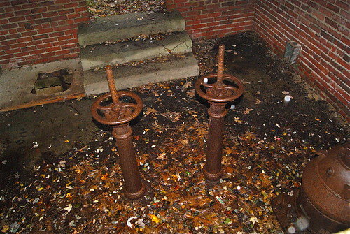
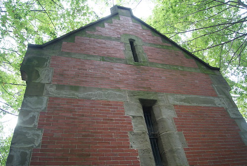
My final stop on the tour took me to an old gate house near the Mason-Rice Elementary School. The building is small but quite impressive, and you can hear the water rushing underneath.
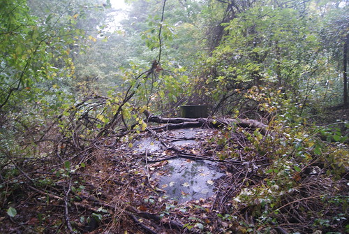
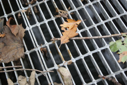
A hop over a fence and a scramble down a small hill lands you at this grate, where you can actually see the water rushing by.
Stay tuned for the second and third parts in this series.
Honestly, I could keep this site going simply by posting about the out-of-the-way places I find in and around my adopted hometown of Newton, MA. But if I changed the blog's title to "The Backside of Newton," people might think I was consumed with Sir Isaac, or Juice or Fig.
So I'll keep things the way they are, but the content I post here is going to remain skewed toward Eastern Massachusetts, 'cause I don't get around much.
As with many things in Newton and surrounding towns that I've posted about before (see June 27, 2011, "War of the Worlds," and May 19, 2010, "Nuclear Dump Playground?"), the aqueducts that are the subject of today's piece are things I've driven past countless times and wondered about.
There are two of them: the Cochituate and the Sudbury. The Cochituate was built between 1846-48 and conveyed water from Natick's Lake Cochituate through several towns before reaching its final destination, Boston. The aqueduct was taken out of service in 1951, replaced by other systems.
The Sudbury was constructed between 1875-78 and brought water from Framingham to Boston. It, too, was taken out of service many years ago, replaced by three other delivery systems. However, in May 2010, the Sudbury was put into emergency use when the Weston Aqueduct suffered a major rupture. The Sudbury remains part of the Massachusetts Water Resources Authority's (MWRA) emergency backup service (thanks, Wikipedia!).
For that reason, I shouldn't have been surprised when two MWRA workers questioned why I was taking pictures of visible remnants of the aqueduct. I assured them I was only interested in the history of the water system. I told them I ran a web site featuring abandoned factories and old bridges, and that satisfied them enough to point out the Cochituate aqueduct, which at certain points in Newton runs adjacent to the Sudbury.
One of the things I love about living in and traveling around New England is that I'm surrounded by the past. Just off a main drag running north to south through Newton, you find this pleasant entrance to the Sudbury Aqueduct:
After disappearing underground for about half a mile, the aqueduct reappears in the spot where I encountered the MWRA workers. This picture was the one they seemed most concerned about.
Pop the lock off this old hatch and you'd be able to lower yourself into the aqueduct. Obviously, the MWRA is concerned about somebody accessing the water supply and poisoning it. I guess I have an honest face. Or perhaps they took down my license plate and are shadowing my every move.
As I said, they were nice enough to direct me across the street to the trail that follows the old Cochituate Aqueduct. I don't know for sure that the waterway was made from bricks, but I'm guessing it was based on this picture.
The trail continues on through some private property, and while I didn't go that far, I enjoyed this sign.
My final stop on the tour took me to an old gate house near the Mason-Rice Elementary School. The building is small but quite impressive, and you can hear the water rushing underneath.
A hop over a fence and a scramble down a small hill lands you at this grate, where you can actually see the water rushing by.
Stay tuned for the second and third parts in this series.
Saturday, November 5, 2011
Goodwill and Good Luck on the Wrong Side of the Tracks
From Joe Viger:

Duluth is a cool town. It sits on the shore of Lake Superior, the largest lake in the world. Gitche Gumee. This photo of Duluth screamed Backside to me. I’m not exactly sure why. So, even though I made the image several weeks ago, I still hadn’t posted anything to the blog.
I’m still not clear on why it’s an image from the Backside. I have my theories.
Maybe it’s a Backside image because train yards are rare today. We like days gone by. Maybe it’s because even before I hit town I had "The Wreck of The Edmund Fitzgerald" buzzing in my head. A melancholy song about Lake Superior that evokes images we like here on the Backside… wrecked tools of industry and the stories of people who are part of real working America.
Maybe it’s because bustling downtown Duluth -- the beautiful Canal Park, convention center and the arena where the National Champion University of Minnesota Duluth hockey team faces off -- is barely a quarter mile from where I made this image. The train yard seemed a world apart from the Duluth most visitors experience. The side of a place most folks don’t see is classic Backside subject matter.
Quite likely the two messages in the image are meaningful… Goodwill and "Is this your lucky day?" Many photographs and stories that have appeared here on the Backside speak to hopes, dreams and luck… good and bad.
What do you think? Give me your sense of this picture as the Backside of America.
Subscribe to:
Posts (Atom)
Scrambling Through Boston's Egleston Square
From Dave Brigham: I've danced around Boston's Egleston Square quite a bit over the years I've been publishing this blog. I...

-
From Dave Brigham: During the time I've been wrestling with this post you could've written, cast, shot, edited, promoted, released...
-
From Mick Melvin: This building is an unsolved mystery for me. It sits on a property with a few other buildings on Bartholomew St. in Hartf...

