Wednesday, January 27, 2016

Finding Hope, But Losing a Mainstay, in Clinton

From Dave Brigham:

Man, that's a bad pun in the title. Is it a pun? Either way, I'm not sure why I ended up with a vague Bill Clinton reference up there. On to the post....

My initial attraction to Clinton, Mass., was the long-abandoned train tunnel. The site is pretty famous among urbex photography people, and graffiti-loving teenagers and those who like to get spooked walking through an 1,100-foot, nearly pitch-black tunnel. The day I was there last fall, I ran into a younger version of myself, a bearded guy with glasses taking pictures of the place after having spied the words "Abandoned train tunnel" on Google Maps or some other online navigational aide.

So let's get those photos out of the way. I'm not trying to minimize how cool this place is, but there's so much more in this former mill town that was incorporated in 1850 (separating from Lancaster) thanks to the efforts of Erastus Brigham Bigelow.

(This was my first view of the tunnel, after crossing a very busy road and scrambling up a short hill.)

(Naturally there is a LOT of graffiti; this work is the most elaborate.)

(The eastern end of the tunnel is much more serene, and has been vandalized very little.)

(I lingered for a few minutes talking with my fellow photographer. Then it was time to head back through, flashlight in hand.)

(Central Massachusetts Railroad trains once came out of the tunnel and continued on a bridge across the Nashua River. This is what's left of the bridge.)

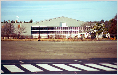
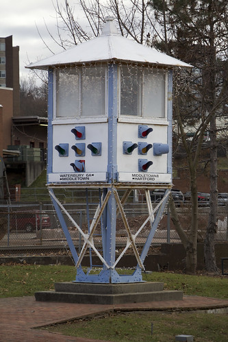
While researching Clinton before my visit, I learned that the town of 13,600 lays claim to the world's oldest continuously used baseball field: Fuller Field. Around since 1878, the field doesn't look historic, but rather just like any other place where America's Pastime is played. There are two sorta cool ticket booths there.

Alas, in 2008, just one year after the Guinness Book of World Records recognized Fuller Field with its superlative, the title was taken away and handed to Labatt Park in London, Ontario, Canada.

(Clinton is the home to one of three North American manufacturing facilities for UK-based cereal maker Weetabix. I love their colors. This part of their facility is just behind the historic Lancaster Mills, which is being developed into condos.)

(Just down the street from the Weetabix entrance is an abandoned store.)

(And a little further down the street I found this old trestle, part of an old rail system that once served the factory and mill.)

(On that same stretch I found this place. I'm fascinated by houses with storefronts tacked on. I rarely see one that's an active retailer or small office. Wonder what used to be here.)

Clinton's got a nice downtown, with lots of stores, restaurants, offices, churches and a really big mill complex.

(I love this simple mural.)

(Such a cool sign. The Old Timer - "A touch of Ireland in New England since 1929." Unfortunately, according to this column in the Boston Globe today, the place is slated to close in two weeks.)

(St. Nicholas Greek Orthodox Church, built in 1900.)

(Smoke stack behind Saint John the Guardian of Our Lady Parish. Incinerator? Crematory?)

(This smokestack looms over the former Bigelow Carpet Mill, a massive complex featuring multiple buildings.)

(Another former Bigelow mill building, which evidently was also used as a distillery.)

Wednesday, January 20, 2016

Hangar Stake

From Derek Watt:

The Backside Gang is happy to welcome a new contributor: Derek Watt. Derek recently explored Massachusetts' Naval Air Station South Weymouth, which was in operation from 1942 until 1997, when it was decommissioned. All of his shots were taken with 35mm..

26 Dec 15 04

(At one point, I believe there were 2 (or more) hangars.)

26 Dec 15 02

(This air tower is one of two at the site -- the older one.)

26 Dec 15 01

(The basketball hoop is located next to the air tower, presumably for the service personnel to use for recreation?)

In July 2015, a developer announced plans to combine housing, restaurants, businesses, a sports complex and a movie studio (in the hangar) on part of the old base, which spans the towns of Abington, Rockland and Weymouth.

Thursday, January 14, 2016

Traffic Stop

From Mick Melvin:

I was traveling to see my cousin in Meriden, CT, recently and made a wrong turn while heading to her house. I made an awesome discovery because of my lack of direction. The funny thing is, I came across an old traffic light on my journey. In downtown Meriden, there is a Traffic Control Tower dating back to 1925.

Untitled

The tower was patrolled by police officers who controlled the traffic from on high. I have never seen anything like it in my 50 years. The tower was quite innovative at the time, but it was removed after several years of contention.

The new rotary traffic system, which moved traffic along at a quicker pace, replaced the tower in 1967. The tower was moved to Giuffrida Park for many years and fell into disrepair. It was refurbished and moved to its current location in 1993. It now sits on the south side of the intersection of Colony St. and Hanover St.

For a related story with more facts and old pics of the tower with police officers in photo, click this link.

Wednesday, January 6, 2016

Suburbex Adventure

From Dave Brigham:

As regular readers of the blog know, I don't do urbex. I'll scramble through tunnels, walk along abandoned train tracks and wander around the edges of derelict buildings, but I don't go inside. This is largely to do with the bad optics of a 50-year-old father of two kids under age 14 getting busted for trespassing. When I was a kid I loved exploring houses under construction in my neighborhood, and, on one occasion, a house that had been abandoned with everything still inside (see September 20, 2011, "In Search of President Little").

I won't lie and say I've never trespassed in service of taking photos for this blog. But until recently, I'd never been called on it.


The 1,667-acre Oxbow National Wildlife Refuge is spread across the towns of Ayer, Shirley, Lancaster and Harvard, Massachusetts, and was once part of Fort Devens. In an earlier drive through the beautiful part of Harvard known as Still River, I'd heard gunfire off in the distance, which I assumed was coming from the section of Fort Devens that wasn't deactivated.

And yes, as I approached this bridge I could hear live rounds being fired, but there were no signs on the bridge indicating "No Trespassers Allowed!"

So after snapping a few photos, I strolled across, walked between the two sections of chain link fence where a lock had been broken off at some point, and began ambling down a paved road between the trees. I could hear gunfire off to my left, but again, saw no signs. Up the road, through the trees, I spied some buildings, and got excited at the prospect of taking pictures of an abandoned military installation. The closer I got, however, the more I heard the rounds rattling off, and the easier it was for me to see that these were newer buildings, not old ones.

About five seconds after I turned around to head back the way I'd come in, I was met by the dude in the pickup truck who I speak of above. He wasn't mad, and understood that the base wasn't doing a very good job of warning people away. "Yeah, somebody broke the lock off a while ago," he said. "Not sure why they haven't fixed it."

I don't know if he was military, or just a contractor, but he was nice enough to let me wander back to the refuge. Once safely back in the right place, I was frankly a bit bored. While the Tank Road and Turnpike Path are very pleasant to walk along, there are no opportunities for backside pictures.

Cape Cod Lobster Joint Can't Claw Its Way Back to Life

From Dave Brigham: Lobster shacks and Cape Cod go together like Cape Cod and lobster shacks. But the unimaginatively named American Lobs...