Happy Halloween from the Backside Gang (Not Safe for Work)!:
Sunday, October 30, 2011
Monday, October 24, 2011
Love Barn
From Dave Brigham:
I've driven west many times on Route 20 past signs for Sudbury's Wayside Inn, but had never actually driven down the side road that leads to the oldest inn operating in the U.S.
I drove past slowly the landmark, admiring the historic buildings and beautiful surroundings.
I figured I'd hit the end of the side road and turn around to get back on Route 20 and start heading home. And then I saw the grist mill. Built in 1929, the mill produces roughly five tons of flour per year, according to the inn's web site. It was used by Pepperidge Farm as a production facility from 1952 to 1967, and is the basis for the company's logo (but you already know that if you clicked the previous link).
But as often happens when I stop to take pictures, what seems to be the most interesting feature turns out to just be a gateway drug to something more fascinating.
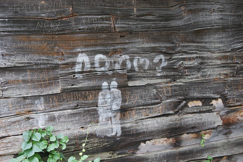
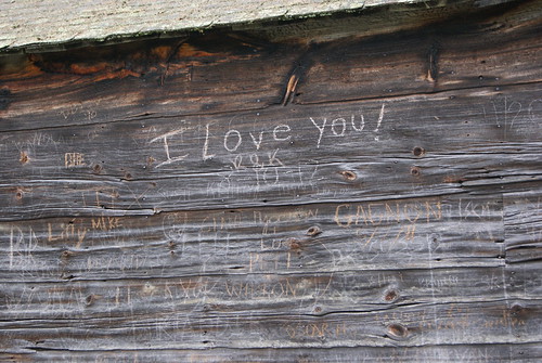
I wandered away from the mill, down a path, and found this old barn.
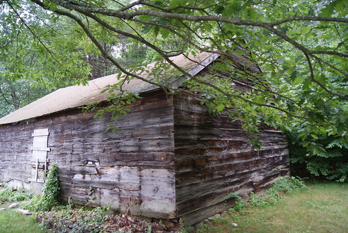
From a distance, it seemed like your standard old New England barn, except that it's boarded up.
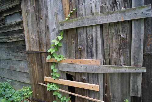
Closer examination, however, revealed quite a few scratched-in sentiments.
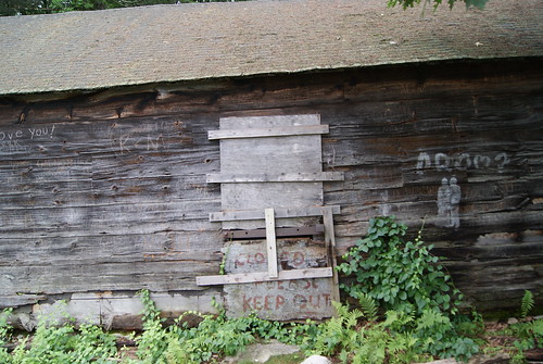
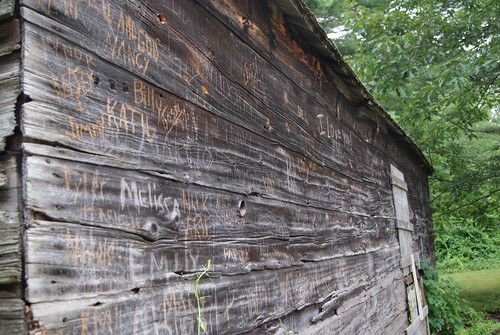
Seems this old barn is quite the romantic hot spot.
I've driven west many times on Route 20 past signs for Sudbury's Wayside Inn, but had never actually driven down the side road that leads to the oldest inn operating in the U.S.
I drove past slowly the landmark, admiring the historic buildings and beautiful surroundings.
I figured I'd hit the end of the side road and turn around to get back on Route 20 and start heading home. And then I saw the grist mill. Built in 1929, the mill produces roughly five tons of flour per year, according to the inn's web site. It was used by Pepperidge Farm as a production facility from 1952 to 1967, and is the basis for the company's logo (but you already know that if you clicked the previous link).
But as often happens when I stop to take pictures, what seems to be the most interesting feature turns out to just be a gateway drug to something more fascinating.
I wandered away from the mill, down a path, and found this old barn.
From a distance, it seemed like your standard old New England barn, except that it's boarded up.
Closer examination, however, revealed quite a few scratched-in sentiments.
Seems this old barn is quite the romantic hot spot.
Thursday, October 20, 2011
UPDATE: Facing Death
From Dave Brigham:
As much as I love ruins, I am equally as excited when such sites get scrubbed clean and turned into useful properties again. Especially a place like the old Faces nightclub on Route 2 in Cambridge, MA (see November 24, 2010, "Facing Death").
As I reported 11 months ago, the site is no longer zoned for entertainment, but rather for office space, R&D and housing. The owners began cleaning the area up roughly two years ago, but not much of note happened until this week.
Quite a few folks, including Cambridge Mayor David Maher, turned out for the ceremonial toppling of the Faces sign, which for 20 years served as an ugly welcome to Cambridge for those arriving from the west. Not only did the heavy machinery tear the sign down, but it also chewed it up, as you can see in these pictures from Boston.com.
According to Boston.com, the property's new owner plans to demolish the nightclub in the next few weeks, and then begin construction of a 228-unit apartment building.
Stay tuned....
Wednesday, October 12, 2011
Troubled Bridges Over Water
From Dave Brigham:
The single greatest achievement in my adopted hometown of Newton, MA, in the eight years I've lived here is the creation of a bike path along the Charles River. The section closest to my house was completed in 2004 and marked with the installation of a 140-foot suspension bridge named for the blue herons that live along the river. The path was built by the Department of Conservation and Recreation, based on a master plan developed in the early '90s.
Thanks to the hard work and determination of the DCR, it is now possible to walk, bike or run from Newton's Auburndale section, which abuts Route 128, to Boston's Museum of Science, a distance of nearly 20 miles. The DCR plans to extend the pathway south from Auburndale into neighboring Needham, Dedham and the West Roxbury neighborhood of Boston.
As you can imagine, abutters fought the project over the years, arguing that creation of the path would enable drug addicts and criminals easier access to homes and businesses (see this blog post and discussion).Many abutters thought they owned the land, because it had been unused or unclaimed by the state for so long.In most instances, however, the state owned the land close to the river. Reclaiming the land, clearing it out and providing access to the river was a major undertaking.
To make a long story short, the path is fantastic and people love it. I jog on it a few times a week and see a lot of fellow runners, along with walkers, cyclists, bird watchers, and people commuting to work on foot. And I see blue herons, geese, ducks and other small wildlife.
Yet, despite all the good generated by these paths -- great places to exercise free from car traffic, beautiful places to fish and observe nature, nice areas for dog walking -- there are people opposed to their expansion.
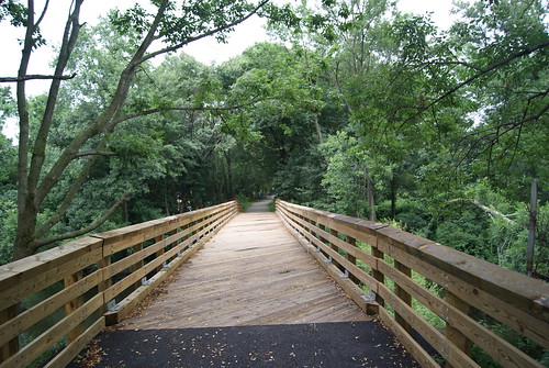
In one case in Newton, neighbors fought against the state when it announced plans to create a walking path over the Charles in the Lower Falls area of the city. The path, which is currently nearing completion, was built over a 100-year-old rail bridge that the DCR has owned since 1975. The path is a short one right now, connecting Washington Street in Wellesley to Concord Road in Newton, but the DCR is considering extending the path to the Riverside MBTA station, where trolleys and buses operate.
Here's what the bridge and path look like:
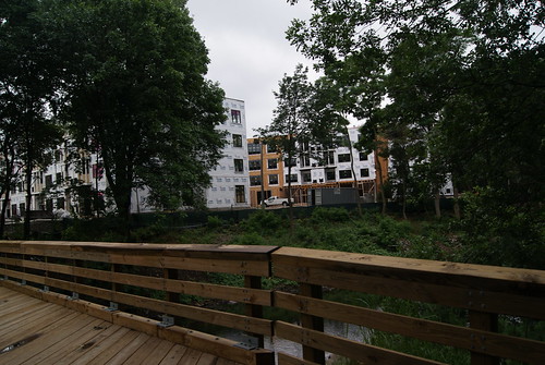
(Looking from the Newton side to a new development in Wellesley)
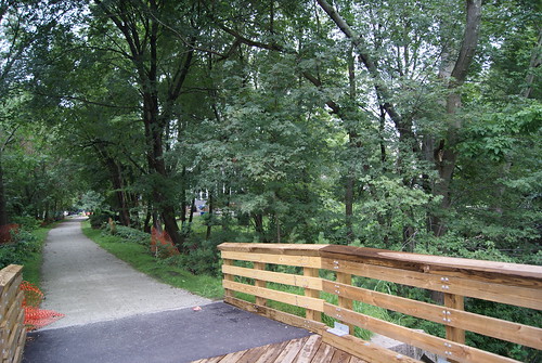
(Looking toward the Newton Lower Falls neighborhood)
(Looking toward the Newton Lower Falls neighborhood)
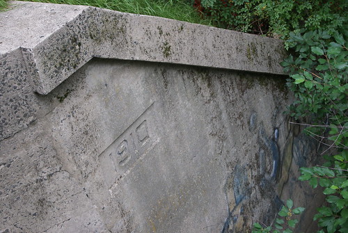
(The original train bridge abutment)
The path provides a nice connection from Concord Road to a commercial section of Wellesley where there are numerous restaurants and shops. It's a scenic little jaunt and one that I'm sure neighbors will enjoy making once the path is completed. Will there still be grumbling? Sure, but it's all gonna go into the wind.
Not too far away from the new Lower Falls path is the Riverside Park Pedestrian Bridge, which connects Newton's Auburndale section with the town of Weston. The bridge spans the Charles River, and has been closed for quite some time due to instability. There are plans in the works by the state Department of Transportation to rehabilitate the bridge and open it for foot traffic.

Once again, neighbors are taking part in public forums to express their reservations about reopening the bridge and opening up their neighborhood to unknown elements. Like the Lower Falls bridge, this one, too, will surely be completed and enjoyed thoroughly by people who just want to share in the river's beauty.
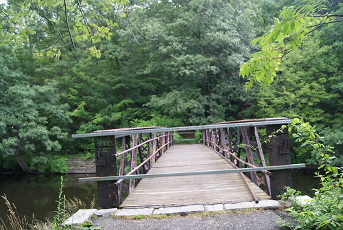
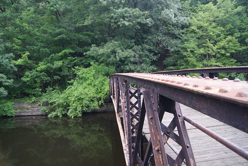
About a quarter of mile down river from the Riverside bridge I found this old crossing.
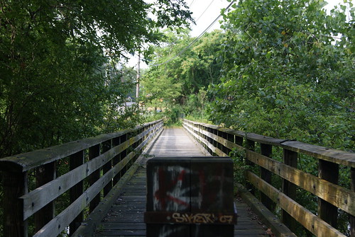
Located next to the Lasell College boat house, this bridge dead-ends near a site that I believe is a staging area for the state's Department of Transportation construction projects on nearby Route 128. I have no idea whether this bridge will be opened at the other end at some point, but as far as I'm concerned, in case it wasn't obvious enough already, I believe that the more ways to access a river, the better.
(For more on Charles River crossings, see May 12, 2010, "Dead-End Tracks, Part I.")
The single greatest achievement in my adopted hometown of Newton, MA, in the eight years I've lived here is the creation of a bike path along the Charles River. The section closest to my house was completed in 2004 and marked with the installation of a 140-foot suspension bridge named for the blue herons that live along the river. The path was built by the Department of Conservation and Recreation, based on a master plan developed in the early '90s.
Thanks to the hard work and determination of the DCR, it is now possible to walk, bike or run from Newton's Auburndale section, which abuts Route 128, to Boston's Museum of Science, a distance of nearly 20 miles. The DCR plans to extend the pathway south from Auburndale into neighboring Needham, Dedham and the West Roxbury neighborhood of Boston.
As you can imagine, abutters fought the project over the years, arguing that creation of the path would enable drug addicts and criminals easier access to homes and businesses (see this blog post and discussion).Many abutters thought they owned the land, because it had been unused or unclaimed by the state for so long.In most instances, however, the state owned the land close to the river. Reclaiming the land, clearing it out and providing access to the river was a major undertaking.
To make a long story short, the path is fantastic and people love it. I jog on it a few times a week and see a lot of fellow runners, along with walkers, cyclists, bird watchers, and people commuting to work on foot. And I see blue herons, geese, ducks and other small wildlife.
Yet, despite all the good generated by these paths -- great places to exercise free from car traffic, beautiful places to fish and observe nature, nice areas for dog walking -- there are people opposed to their expansion.
In one case in Newton, neighbors fought against the state when it announced plans to create a walking path over the Charles in the Lower Falls area of the city. The path, which is currently nearing completion, was built over a 100-year-old rail bridge that the DCR has owned since 1975. The path is a short one right now, connecting Washington Street in Wellesley to Concord Road in Newton, but the DCR is considering extending the path to the Riverside MBTA station, where trolleys and buses operate.
Here's what the bridge and path look like:
(Looking from the Newton side to a new development in Wellesley)
(Looking toward the Newton Lower Falls neighborhood)
(Looking toward the Newton Lower Falls neighborhood)
(The original train bridge abutment)
The path provides a nice connection from Concord Road to a commercial section of Wellesley where there are numerous restaurants and shops. It's a scenic little jaunt and one that I'm sure neighbors will enjoy making once the path is completed. Will there still be grumbling? Sure, but it's all gonna go into the wind.
Not too far away from the new Lower Falls path is the Riverside Park Pedestrian Bridge, which connects Newton's Auburndale section with the town of Weston. The bridge spans the Charles River, and has been closed for quite some time due to instability. There are plans in the works by the state Department of Transportation to rehabilitate the bridge and open it for foot traffic.
Once again, neighbors are taking part in public forums to express their reservations about reopening the bridge and opening up their neighborhood to unknown elements. Like the Lower Falls bridge, this one, too, will surely be completed and enjoyed thoroughly by people who just want to share in the river's beauty.
About a quarter of mile down river from the Riverside bridge I found this old crossing.
Located next to the Lasell College boat house, this bridge dead-ends near a site that I believe is a staging area for the state's Department of Transportation construction projects on nearby Route 128. I have no idea whether this bridge will be opened at the other end at some point, but as far as I'm concerned, in case it wasn't obvious enough already, I believe that the more ways to access a river, the better.
(For more on Charles River crossings, see May 12, 2010, "Dead-End Tracks, Part I.")
Sunday, October 2, 2011
Parking Lot Limbo
From Dave Brigham:
Life is full of so many little mysteries, many of which can be solved with a little Internet searching. Some head-scratchers, however, I prefer not to reason out. It's more fun to speculate.
For many months, or perhaps as long as a year, I've jogged and driven past this car.
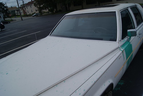
It's a Cadillac; I believe it's a Fleetwood. Late '80s/early '90s.
It's located in the parking lot of Queen Screw & Manufacturing, a small factory situated in a small but relatively busy industrial area just over the Newton line in Waltham, MA. For quite some time, I figured some joker had splashed paint on the car and that whoever owned the Caddy didn't have enough money to get it repainted. Maybe they'd grown to like the distinctive mark the paint made.
But on a few early morning jogs, I saw the car alone in the lot, long before anyone was working in the factory. And I stopped long enough to realize that the paint that had been splashed on the car had dripped to the ground and the car had evidently never been moved since that time.
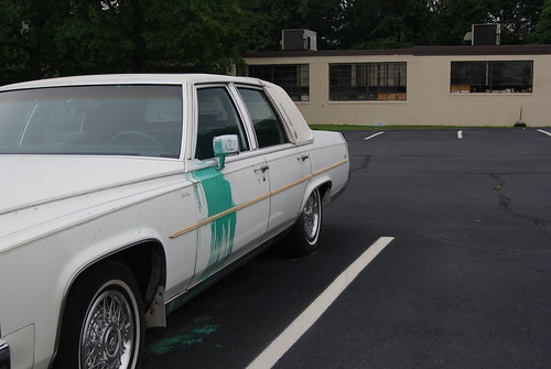
So I figured perhaps the car's owner had died, and the Caddy had been left there in honor of him (or her). But who splashed it with paint, and why? And when? Was the car sitting there for a long time before someone doused it? Or did the owner abandon it once the paint hit the door (and some of the hood, which I didn't realize until I finally busted out my camera)?
Why is this car taking up valuable space in the company's small parking lot? Why hasn't it been defaced more than it is? That white canvas seems to be just calling out for graffiti, doesn't it?
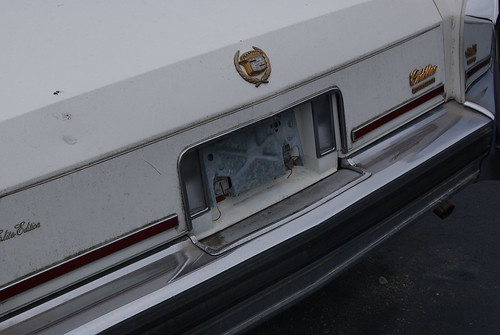
The car has no plates on it, so evidently it's unregistered. I suspect one day I'll go by this lot and the car will be gone. Taken out of limbo by mysterious hands.
Life is full of so many little mysteries, many of which can be solved with a little Internet searching. Some head-scratchers, however, I prefer not to reason out. It's more fun to speculate.
For many months, or perhaps as long as a year, I've jogged and driven past this car.
It's a Cadillac; I believe it's a Fleetwood. Late '80s/early '90s.
It's located in the parking lot of Queen Screw & Manufacturing, a small factory situated in a small but relatively busy industrial area just over the Newton line in Waltham, MA. For quite some time, I figured some joker had splashed paint on the car and that whoever owned the Caddy didn't have enough money to get it repainted. Maybe they'd grown to like the distinctive mark the paint made.
But on a few early morning jogs, I saw the car alone in the lot, long before anyone was working in the factory. And I stopped long enough to realize that the paint that had been splashed on the car had dripped to the ground and the car had evidently never been moved since that time.
So I figured perhaps the car's owner had died, and the Caddy had been left there in honor of him (or her). But who splashed it with paint, and why? And when? Was the car sitting there for a long time before someone doused it? Or did the owner abandon it once the paint hit the door (and some of the hood, which I didn't realize until I finally busted out my camera)?
Why is this car taking up valuable space in the company's small parking lot? Why hasn't it been defaced more than it is? That white canvas seems to be just calling out for graffiti, doesn't it?
The car has no plates on it, so evidently it's unregistered. I suspect one day I'll go by this lot and the car will be gone. Taken out of limbo by mysterious hands.
Subscribe to:
Posts (Atom)
Former Rock Club in the Fenway Slated for Redevelopment
From Dave Brigham: Sometime in the late '90s/early aughts, I saw one of the greatest Boston bands of all time, the Upper Crust , in a ...

-
From Dave Brigham: During the time I've been wrestling with this post you could've written, cast, shot, edited, promoted, released...
-
From Mick Melvin: This building is an unsolved mystery for me. It sits on a property with a few other buildings on Bartholomew St. in Hartf...

