From Dave Brigham:

(Bench in Houghton Garden, Chestnut Hill.)
Chestnut Hill is arguably the chicest of Newton's villages. Waban has loads of beautiful homes on large, wooded lots. In West Newton Hill, gorgeous Victorians abound. But Chestnut Hill -- which is comprised of parts of Brookline and Boston as well as Newton -- has enormous estates and old-money history, as well as a fairly good-sized backside.
When I think of Chestnut Hill, I think of captains of industry (New England Patriots owner Robert Kraft), old-money WASPs (at least one Saltonstall), professional athletes (Tom Brady) and other highfalutin types living behind high walls or gates. In my mind, they drive from their well-appointed homes in brand new BMW's or Teslas, directly into Boston for sumptuous meals at private clubs, or to a well-guarded helipad for a weekend on Nantucket. Their kids go to private school, and are named Teddy and Hampton and Tessa and Stella. They are mostly white, these people in my mind, as you can tell.
While I'm sure that Chestnut Hill is more diverse than I realize -- watching "Keeping Up with the Kardashians," shopping at Star Market and worrying about bullying and teen drug addiction and Donald Trump, like the rest of us -- there is definitely still an element of the "Essex Colony" that moved into the area back in the 1850's.
"In 1822, Joseph Lee came from Beverly and bought one hundred and sixty acres of the old Hammond Farm," according to Newton's 19th Century Architecture: Newton Centre, Oak Hill, Chestnut Hill, Commonwealth Avenue, issued by the Newton Historical Commission and the City Department of Planning and Development in 1985. When he died in the mid-1840's the land passed to his six nieces and nephews, who initially did little with the property. In the 1850's, however, "when Beacon Street and the railroad improved communication between Boston and Newton, several family members decided to settle there."
The family laid out roads and built houses, dubbing the new neighborhood Chestnut Hill. Among the families to settle in the newly constructed enclave were the Lees, the Saltonstalls, the Cabots and the Lowells, blue bloods through-and-through from Boston's North Shore (the name Essex Colony comes from Essex County in Massachusetts), according to the NHC/DPD booklet.
"The original Lee properties shown on the 1856 plan of 'Chestnut Hill' lay roughly between Beacon Street, Reservoir Avenue, Hammond Street and the railroad tracks," according to the booklet. "Some of the acreage lapped over into Brookline, accounting for that area of Brookline also called Chestnut Hill. As succeeding generations married, they were provided with house lots in Chestnut Hill and many of these houses remain, still lived in by descendants of the original families."
This document is 30 years old, but I'm sure there are still descendants of those families, and other original Chestnut Hillers, living there.
Despite a collective effort to maintain manicured lawns, employ a constant stream of renovation contractors and obtain privacy, Chestnut Hill has hidden elements that aren't really that hard to find.
Welcome to the sixth part of my series on the villages of my adopted hometown of Newton, Mass. For links to the previous five installments, and a tease about the next in the series, see the bottom of this post.
Chestnut Hill could just as easily have been named Hammondville. The family of Thomas Hammond Jr. were among the first white settlers in the area, in 1655. The village features Hammond Pond, Hammond Woods, Hammond Street and Hammond Pond Parkway. As stated above, the old Hammond Farm was carved up to become the heart of the early residential area of Chestnut Hill.

(Hammond House, the oldest in Newton.)
Known as the Hammond House, the property at 9 Old Orchard Road was built in 1714 by Thomas Hammond Jr., according to the National Register of Historic Places nomination, and is considered the oldest house in Newton. The house is currently on the market for just under $3 million; Coldwell Banker lists the house as being built "c.1645." I'm not sure what the correct date is, but I recommend clicking on the listing link to check out photos of this cool residence.
Just around the corner from the Hammond House is the Mary Baker Eddy Home.

(The backside of the Mary Baker Eddy Home.)
Founder of the Church of Christ, Scientist, Eddy lived in this house from 1907 until hear death at age 89 in 1910. She extensively remodeled the home, which was built in 1880, according to the Longyear Museum, which owns the home.
South of the Eddy home is the Webster Conservation Area, part of which was opened to the public in 1916 when the owner, Edwin Webster, gave 38 acres to the Commonwealth of Massachusetts, according to the Newton Conservators web site. In the ensuing decades Webster gave additional acreage, and the State took other portions of the land, as well as some Hammond land, by eminent domain for conservation, according to the Conservators.

This building was in the section of the conservation area known as the Deer Park. According to the Conservators web site, "Mrs. Webster brought a couple of dozen deer into the area many years ago." Many times over the last 15 years or so I spied deer on this property as I sped by on the busy Hammond Pond Parkway. I found it very cool to see wildlife frolicking in such a busy area. Alas, there are no more deer on the property, according to the Conservators. This building, which may have been part of a chicken farm at one point, was torn down recently.
Just steps away from where the shed/coop/barn once stood is Houghton Garden.

"From 1906 through 1940 Mr. and Mrs. Clement Houghton created a garden adjacent to their home at 152 Suffolk Road in Chestnut Hill," according to the web site for the Chestnut Hill Garden Club. "Mrs. Houghton served as the president of the American Rock Garden Society and her love of rock gardens resulted in one of the first of its kind. Their alpine rock garden is situated on a ledge overlooking Houghton Pond. It contains many dwarf conifers originally imported from the Orient by the Houghtons." The garden was listed on the National Register of Historic Places in 1999.

I've walked through this garden several times over the years. It's very peaceful despite the fact that it sits mere feet from the busy trolley tracks. Because of this proximity to the trains, my son loves going to this area.

I made my guess about the chicken farm because along the trolley tracks that separate the Deer Park from Hammond Pond conservation area, there is an official sign that says "Chicken Farm Truck Pad," where vehicles from the Massachusetts Bay Transit Authority (MBTA) can drive up to the tracks. There is also a pedestrian crossing here from the gardens to the pond.

(A rusty old rail cart sits next to the pedestrian crossing.)
The Hammond Pond area has some cool paths and rock walls where I've seen climbers testing their skills. On the other side of the Hammond Pond Parkway stands another section of the Webster Conservation area.
Signs urging the city to "Save Webster Woods" have sprung up since Boston College announced its purchase of Congregation Mishkan Tefila earlier this year. The college plans to use the former synagogue site for "parking and administrative uses," according to this Newton Tab article. But it is the 20+ acres of undeveloped land (i.e., Webster Woods) and B.C.'s potential use for that property that has many folks, including me, concerned.

(Half-submerged rock in small pond in Webster Woods.)
Worth saving, don't you think? Stay tuned...
Just a short distance away is a shopping area known as The Street.

(The Street outdoor shopping mall.)
The site along very busy Route 9 has been a retail destination since 1950, according to the official timeline on The Street's web site.

Above is the faded facade of the former AMC Theater, which opened in 1975 as a General Cinema. In the last few years, a new theater, Showcase Superlux, opened at the site.
Long before the retail development of this area, very different types of activities took place here. On an old map at the City of Newton web site, I spied something that said "Posse-Nissen School." It didn't take long to find out a bit more information online. The Posse-Nissen School of Physical Education specialized in Swedish Gymnastics, a system of calisthenics and exercises developed by Hartvig Nissen, a Swede who was director of the massage department at Boston City Hospital, and Nils Posse, a Swedish royal who moved to Boston in the late 19th century, according to Wikipedia and The Journal of Physical Education, Recreation and Dance.
At the eastern edge of the retail complex, just past the Star Market grocery store, sits an abandoned property hidden behind fences.

(A staircase that was once part of a home near the Star Market.)
Owned by the Chestnut Hill Shopping Center LLC, the land was sold to the developer by Eleanor Baldwin, according to documents I found online. In a cursory search online I found evidence that Ms. Baldwin was a Chestnut Hill resident for many years. I'd love to know what her old house on this property looked like.
Then there's the house that stands just a short distance away from The Street that has confused me for quite some time.

Listed on the Newton Assessors Database (one of my favorite online tools for research) as "developable land" owned by a trust, the property consists of this old shingled house and a small shed on just under 6.5 acres. I found nothing online for quite some time, but a few months ago I stumbled across information about architect William Ralph Emerson and houses he built in Chestnut Hill.
"The prominent architect William Ralph Emerson is known to have designed at least two houses in Chestnut Hill. Reusing an old barn, Emerson developed a striking Shingle style house for John Lowell which still stands at 517 Hammond Street." -- from a document published in 1985 by the Newton Historical Commission and the city's Department of Planning and Development.
But then I realized that 517 Hammond Street is next door to this property. Perhaps he also designed the long-abandoned house in the above photo. I need to visit Newton City Hall to find out more information.
The neighborhood just to the north of this neglected house, over the MBTA trolley tracks, is filled with stately mansions and beautiful churches. The lawns are green and constantly filled with contractors and landscapers running to and fro. Along Suffolk Road sits this reminder of times gone by.

(An old gate post, perhaps original to the neighborhood, stands on Suffolk Road.)
Back on Route 9, just a short distance west, once stood the Atrium Mall. Opened in 1989, the mall catered to the well-to-do of Chestnut Hill and surrounding areas. I used to like to take my kids there when they were young, because the mall had a playroom. But the high-end Atrium couldn't compete with downtown Boston shopping and the larger Natick Mall, located less than 10 miles away.
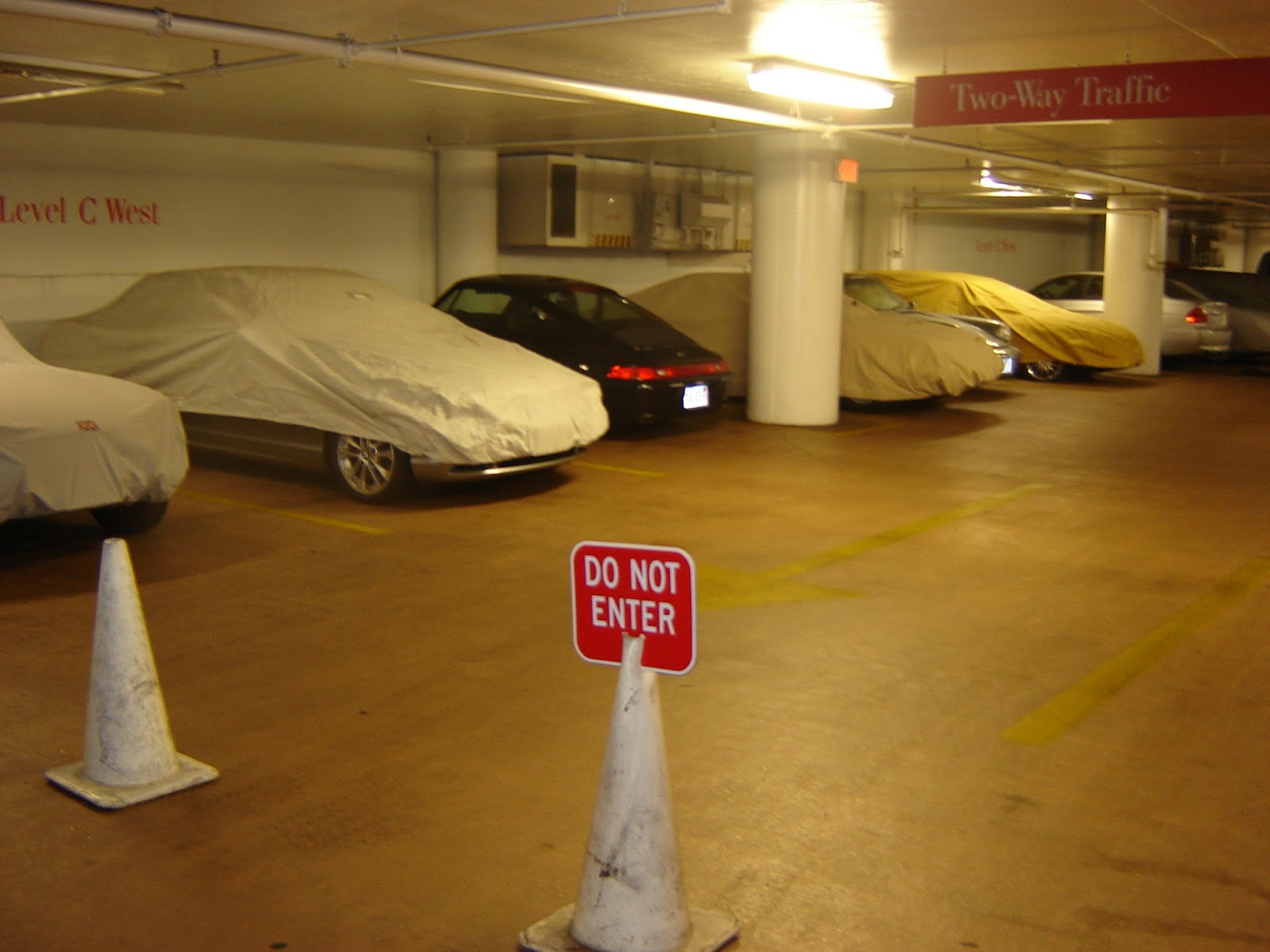
The parking garage under the mall was a cool place to spot sports cars and vintage vehicles under wraps.

Perhaps the cars' owners lived in some of the nearby high-rise apartment buildings that didn't have a lot of parking.
I took that photo a number of years ago. The mall closed four years ago and has been converted to an athletic center and medical offices
Just a short hop away from the old Atrium Mall, and across the street from the Mall at Chestnut Hill (and not far from The Street -- yes, Chestnut Hillers love to shop!) once stood an ugly strip mall/office complex/grocery store.

(The backside of the former Omni Foods grocery store, which was torn down a few years back to make room for the Chestnut Hill Square shopping area.)
A short jog down Route 9 and you're at Kennard Park on Dudley Road, the western edge of Chestnut Hill.

The City of Newton acquired the land in 1978 from Dr. Harrison Kennard, according to the Newton Conservators web site. This is a very pleasant, nicely wooded park, with old stone walls, lean-tos, remnants of an orchard, the old Kennard house, which serves as headquarters for the town parks and recreation department, and well-kept paths that eventually lead to a small pond over the town line in Brookline.
At the far eastern end of Chestnut Hill stands Boston College, which spills over into Boston's Brighton neighborhood. Across Beacon Street from the college's dorms, in a small patch of woods next to a dirt parking lot, stands this lovely statue.

The street abutting the statue is a dead end now, but used to go through.

Amidst the beautiful homes dotting the south side of Beacon Street as you wind eastward toward Boston sits this impressive pile.

The old gate house for the Chestnut Hill Reservoir across Beacon Street, this Romanesque building was erected in the late 1870's and controlled the flow of water from both the Cochituate and Sudbury aqueducts, according to Wikipedia.
Not far from the Chestnut Hill Reservoir sits the Waban Hill Reservoir.

(Waban Hill Reservoir and gate house.)
The City of Newton began construction on this reservoir in 1875, as part of its effort to supply all of its 13 villages with water. The water was drawn from the Charles River, near the Needham line, and pumped by coal-fired steam engines through the mains and across the city, according to Historic Newton's "Waban Hill Reservoir History."
I've explored the area near the location of the former pumping station on Needham Street (see November 20, 2011, "History Flows On, Part II," and December 6, 2011, "History Flows On, Part III").
Newton sold the reservoir to the Boston Metropolitan Water Board in 1900, according to the Newton Conservators web site. In 1891, the City of Newton completed construction of the reservoir's replacement, a covered, 10-million gallon structure just up the hill.
Across Commonwealth Avenue from the old reservoir sits this funky building with a cool roof.

Currently home to a fitness studio and a custom fabric and design shop, this place was built in 1920 and was used from 1925-1972 as a pharmacy and grocery store, according to property documents on file with the City of Newton. In ensuing years the building served as a real estate office and an insurance agency.
And thus completes my survey of Newton's Chestnut Hill village. As with all of the installments in this series, I could have dug more into Chestnut Hill. I plan to do so in the future, in the hopes of writing a book covering all of Newton's 13 villages.
Here are links to the previous five installments, ordered from most recent:
September 26, 2016, "I Seek Newton, Part V: Oak Hill"
June 3, 2016, "I Seek Newton, Part IV: Waban"
March 23, 2016, "I Seek Newton, Part III: Highlands"
September 20, 2015, "I Seek Newton, Part II: Auburndale"
May 21, 2015, "I Seek Newton, Part I: Lower Falls"
I'm not sure which village will be next. There are seven more, some more involved than others. Most likely I'll report on Thompsonville, the smallest and least commercialized village.