Showing posts with label grocery store. Show all posts

Saturday, March 11, 2023

The Pros and Cons of Winter Hill and Gilman Square

From Dave Brigham:

Welcome to the first of several posts about Somerville, Mass., a city once derided as "Slummerville" that has become a hot market for residential and commercial properties in recent years. Today's installment covers, as you may have guessed by reading the headline, the Winter Hill neighborhood and its Gilman Square area.

Pro: Gilman Square recently became one of the newest stops on the MBTA's Green line, part of a long-awaited extension running beyond Lechmere station. This is great for Somerville residents, local businesses and the environment.

Con: I should have checked out this neighborhood a decade ago, before some of the industrial buildings that I love to shoot were torn down.

Pro: I still found plenty of interesting things both in Gilman Square and Winter Hill as a whole. The proof is below.

Con: I found locations where the Winter Hill Gang once hung out, back in the latter third of last century.

See what I did there?

Let's start out in Gilman Square, which is located in the south-central area of Winter Hill, not far from Somerville City Hall and the high school.

As I mentioned, this neighborhood has changed in recent years, and more changes are on the way, which I will discuss below. The square is one of the smaller ones in Somerville. "The Boston and Lowell Railroad came to the area in the mid 19th century, and rapid property development followed," according to Wikipedia. "By the turn of the century, Gilman Square featured a public green surrounded by four-story commercial buildings."

I recall when the square looked that way, but I didn't pay much mind to it. I lived in Somerville from January of 1995 to November of 1997, and drove through here on occasion. More recently, I drove through here once in a while when out on long drives trying to get one or or the other of my kids to take a nap. At least two buildings that I saw back then are gone: A+ Auto Body, at the intersection of Medford and Walnut streets; and the Homans Building, where Pearl Street merges into Medford Street.

I walked past the old A+ Auto Body site, which was also known as Hill-Michie Co. Auto Garage, and found some ruins.

While the garage was found to be eligible for listing on the National Register of Historic Places, that wasn't enough to save it. A report prepared by the Green Line Extension project of the MBTA found that the building was likely the oldest auto garage and car dealership in Somerville. Nevertheless, it was torn down. I'm not sure whether anything will be built in its place. The site looms over the new train tracks (and older commuter train tracks), as well as a part of the Somerville Community Path that is under construction.

As for the Homans Building, it was razed to make way for the new above-ground Green line train station.

"Built in 1929, the building originally served as a distribution facility for Chicago-based company Monarch Finer Foods," according to the above-linked Patch article. "The concrete lion face on the façade, Monarch's trademark, was removed...and will be reincorporated into the Gilman Square neighborhood."

I'm glad that the city and state made an effort to preserve a little piece of Gilman Square's history. The area where the Homans building once stood will serve as an entrance to the station, as well as a park.

To see photos of the old warehouse, check out this Flickr link.

After I run through the cool stuff I found in Gilman Square, I'll talk a little about what the future holds for this neighborhood. Below that, I will feature more from the rest of the Winter Hill area.

Sarma, a small-plates restaurant focused on Mediterranean flavors, is run by Cassie Piuma, who worked for many award-winning chefs before opening this joint in 2013; and Ana Sortun, a Boston food scene bigwig who also operates Oleana and Sofra Bakery, and who has authored cookbooks.

This space was formerly occupied by The Paddock, another foodie destination that had been in business for many years. Sarma has a fantastic exterior mural of an octopus, which is featured on the menu.

The restaurant is located in what is known as the Litchfield Block, which was built in 1891.

"In 1892 the building was occupied by James Litchfield, a grocer who may have been responsible for constructing this block," according to MACRIS. "Between 1914 and 1933 the building had a hardware store and a Western Union office. Professional and residential tenants included a female dentist, a music teacher, two railroad engineers, and a barber."

Sounds like a fun bunch!

Continuing east on Pearl Street, we come to a building with both an awesome present and an interesting past.

Known historically as the New England Telephone Building, or the Telephone Switching Building, this yellow-brick Colonial Revival beauty on the corner of Pearl and Bradley streets was built in 1904. It was the main exchange for the New England Telephone Company from 1904-1933, according to MACRIS. "The Bradley Street exchange handled 14,250 calls per day, was the fourth largest suburban exchange, and employed twenty-three operators and seven mechanics," MACRIS continues.

Today it's a live/work space for dozens of artists, and is known as Mad Oyster Studios.

Just steps away is a church located in a circa-1930 building that used to be...apartments? A store? An engine shop?

I believe that Eglise Evangelique Bethel de Somerville (Bethel Evangelical Church of Somerville) is a Haitian congregation.

Heading east-southeast, I knew I wanted to make a photo of Mudville, a pottery studio that I've driven past many times over the years.

Located at the intersection of Pearl Street and McGrath Highway/Route 28, Mudville was established in 1974, "teaching the basics of pottery to generations of people new to clay," per its web site. The studio closed at some point, but was for a while "available to people familiar with Mudville who are able to work independently," per the web site.

The founder, Nan Hamilton, died in November 2021, so I assume the business is now totally shut down.

The building dates to 1940. I'm not sure what it's prior uses were.

I headed back toward the heart of Gilman Square on the south side of Pearl Street, which is where I found the former Kemp Nut Company building.

Now comprised of at least some artist studios, 226 Pearl Street was built sometime between 1917 and 1924, according to various sources I've found online. It was used to manufacture nut products, and also as a residence for company founder Edward F. Kemp, per MACRIS. The company eventually expanded into a former auto body shop at 100 Walnut Street (now a park), and also used a building along the railroad tracks and a separate shipping building somewhere in Gilman Square, per MACRIS. Kemp's shelled, roasted and salted nuts were sold throughout New England, including at the company's own Golden Glow Shops, MACRIS indicates.

A few doors down is Great Eastern Vintage, which features two fantastic works of art on the exterior.

Diana Ross (top) and Josephine Baker (bottom) were painted by Massiel Grullón. These works represent her first solo exterior murals, per her Instagram page.

Back in the heart of the square, I was dazzled by the artwork on the stairs leading across a small swatch of green space from Pearl Street to Medford Street.

Painted by Liz LaManche, the work is called "The Soul's Journey As A Series of Weird Old Cars." "I made it to honor the late Al Riskalla, longtime friend and owner of ABJ Auto nearby," LaManche says on her web site. "He was beloved in our community for his years of kindness, humor and honesty, creating a safe congenial space & fixing cars affordably for those in need. The design represents the soul’s journey to enlightenment, as a series of old cars. Rainbow tire tracks lead up to the stairs."

Make sure to check out that web link, as you'll get the full effect of the vivid colors when this work was first painted.

The showpiece of Gilman Square is unlike any building I've seen, and I wish I'd made better photos. I was fighting the sun and shadows and the sheer mass of this place.

Known alternately as the Malta Temple and the Signet Commandery, this 1902 Classical Revival building features a "large copper clad relief of a mounted knight...flanked by two small copper clad relief panels of a cross (left) and crown (right)," per MACRIS. The relief gives the building a real sense of intrigue and power. This four-story "orange brick building with brownstone, terra cotta, and copper trim" was built by the "Knights of Malta, a fraternal organization founded in 1896, which, by 1901, had a membership of between 200-300," per MACRIS.

Similar in organization and practice to the Masons, the Knights of Malta was "introduced into America in 1844 by Charles McClintock and George H. Pearce," per the Scottish Rite Masonic Museum & Libraty's web site. The organization's stated purpose was to “unite men under the most binding forms, to comfort one another in the practice of Christian religion...to promote Protestant unity, and to defend the Protestant faith against all foes whatsoever.” The group also provided mutual sickness and death benefits to its members.

In its heyday, the temple "featured a three room bowling alley in the basement, four stores on the first floor with rear entrances, and a billiard room which connected to the basement bowling alley," according to MACRIS. "The second floor was occupied by offices in the front, with a 40 X 50 foot assembly hall in the rear. The hall had a stage, ladies parlor, toilet rooms, and ticket offices, as well as a folding partition to create two small halls. The third floor housed the Knights of Malta apartments and included a commandery room, a coat room, double parlors with large fireplaces and a smoking room. The fourth floor housed a 350 person dining hall and kitchen."

A commandery is a district controlled by a commander of certain medieval orders of knights, per Dictionary.com. I bet the Knights of Malta in Gilman Square had some fancy-ass outfits they would wear in and around the commandery.

These days, this impressive slab of a building is occupied by East Cambridge Piano, which has been in business since 1978; and Boston Billiard Emporium, which has been around since 1972.

Next to the Commandery, in a small lot in front of an apparently out-of-use commercial garage, I spied a really nice example of one of the only American-designed, mass-produced passenger cars with rear-mounted, air-cooled engines (thanks Wikipedia).

That's a Chevrolet Corvair, a first generation model, produced sometime between 1960 and 1964. I hope somebody gets this thing running soon.

Heading up School Street, just southwest of the train tracks, is a nice old apartment building.

Known alternately as The Montrose and the George Goodrich Apartment Building, this fantastic Colonial Revival/Queen Anne rose in 1894. "According to late 19th century drawings, the Montrose was built in the Queen Anne Style with four turrets, which have been removed," according to MACRIS. "Today it resembles a Classical Revival block of three and four stories built into the hill with a high raised brick basement and four projecting bays, two central ones flanking the entrance and one on each end."

MACRIS continues: "The frame apartment building...is somewhat unusual in that the owner / speculator also lived at the Montrose. George Goodrich is listed in City Directories as dealing in drain and sewer pipes. The Montrose was one of 45 apartment 'hotels' listed in the early 20th century directories and had many salesmen and clerks living here."

The final shot from Gilman Square is of a type that I don't usually make: an interior shot.

I was taken by the cozy kitchen of Brianna's Cafe, which is located on Medford Street, next to St. Ann Catholic Church. It is run by a husband-and-wife team who came to this country from El Salvador.

Before I get to the rest of Winter Hill, I want to talk about proposed changes for Gilman Square, now that it has a light-rail station that will allow easier access to Medford and Boston and beyond. Any time a new transportation option opens, new residents and businesses almost assuredly follow.

The two sites of interest are: the Triangle, located where Medford and Pearl streets come together at a point, abutting a large brick apartment building called Pearl Street Park; and 350 Medford Street, former site of the Homans Building. The City of Somerville owns both of these sites, and has conducted Zoom meetings and resident surveys to find consensus around what types of buildings should be constructed, and how high they should be.

According to the Gilman Square Station Area Plan completed in 2014, "A consensus solidified around a vision that Gilman Square's future should resemble its past: a neighborhood square that offered a mix of service, employment, cultural, and transportation options to residents of the station area."

In a 2021 Zoning Feasibility & Massing Study conducted by the city, 36% of survey respondents preferred buildings to be four stories or shorter; 59% of respondents liked the idea of six-story buildings; half of these respondents, or approximately 30% of the total, were open to buildings taller than six stories; and many preferred taller buildings to be closer to the Green Line Station than Medford Street.

I'm not sure what the next steps in the process are.

In a 2014 Gilman Square Station Area Plan, there was a proposal to add a central green between the Triangle and the Malta Temple. I'm not sure whether that is still being considered.

OK, let's get to the rest of Winter Hill, which has a sordid past and, like Gilman Square, a future that includes redevelopment plans. I'll get to that below.

My tour of this neighborhood begins at the Deanna Cremin Playground, located at the corner of Otis Street and Route 28.

This lovely little play space was created in memory of Deanna Cremin, a 17-year-old Somerville girl who was murdered on March 30, 1995, a crime that has never been solved. When the playground popped up on Google Maps, I knew I had to check it out and feature it. I moved to Somemrville in late January/early February of 1995, and remember this horrible crime, as well as the murder of Janet Downing by 15-year-old Eddie O'Brien that summer in the city.

These were both horrible crimes, and I'm surprised that a) no one has been charged in Deanna's murder, although the police seemed to have at least three suspects, and b) Eddie O'Brien was convicted on what seemed to be bad evidence, and with the existence of a suspect who seemed to have motive and access.

Boston music legend Willie "Loco" Alexander wrote a song about Deanna's murder, which one of my favorite local acts, Slide (R.I.P.) recorded.

Now I'm going to the top of Winter Hill, where, at the intersection of Broadway and Main Street, I spied a small salon that's been out of business for a while.

The main building dates to 1921; the little addition for Lourdes Beauty Salon might be from a more recent time.

The hair-care business was established in 1984. The sign looks like it could be fairly new. Currently, the space is for lease.

Strolling southeast along Broadway, I flashed on a relatively minor historic fact about a Very Important Person. I did a quick Google search while stopped along the sidewalk, confirming what, as it turns out, I didn't need to look up after all.

Barack Obama lived at 365 Broadway from 1988 to 1991 while he attended Harvard Law School, which is located about 2.5 miles away in Cambridge.

The house was already historic before the future 44th President of the United States moved in. Known as the Langmaid Terrace, this Queen Anne-style rowhouse was built in 1893, and is "one of the most interesting [residential buildings] architecturally and still commands attention on the busy thoroughfare," per MACRIS. The building was listed on the National Register of Historic Places in 1989.

The photo below showcases a culture clash the likes of which you see all around Boston and its suburbs.

In the foreground is The Pilates Rx, a "concierge studio offering private Pilates instruction and physical therapy & pelvic health services for the modern athlete," per its web site. This business is focused, most likely, on newer, younger Somerville residents who are more inclined to pursue physical fitness. In the background is Winter Hill Liquor Mart, which has been in business since 1974 and has a nice sign that may go back to that date.

Both of these types of places are important to Winter Hill, as they are to any neighborhood. The world works best when there are different types of people doing different things, for different reasons, at different points in their lives. Right?

Anyway, the liquor store building dates to 1910.

That brings me to a long-abandoned grocery store located across a parking lot behind the liquor mart, and the future of this part of Winter Hill.

Shuttered in 2006, the Star Market was located in a building from the 1960s, and left the neighborhood with no grocery store for many years. There is a Stop & Shop not far away, in East Somerville. I'm not sure how long that has been there.

The City of Somerville acquired the old Star Market property by eminent domain after the prior owner, who wanted to bring an Ocean State Job Lot to the site, lost a zoning decision and an appeal. The city hired Mark Development, whose portfolio includes the Trio apartment development in Newton and The Landing in Hudson, to develop the site, which has been dubbed Temple Square, after an abutting street.

Mark Development recently announced that its plan for underground parking at the proposed 299 Broadway project in Winter Hill hit a major roadblock in the form of previously unknown asbestos on the site, according to The Somerville Times.

Mark Development planned to request a waiver from the Zoning Board of Appeals for a percentage of future residents to gain on-street parking, according to the Times article. I'm not sure the status of that waiver, or the project.

In November 2016, the City of Somerville completed its Winter Hill Neighborhood Plan, which calls for rejuvenating Broadway as a commercial thoroughfare, and reconnecting Winter Hill to the rest of Somerville, physically and culturally. Additional ideas include adding affordable housing, increasing office space and making the area more pedestrian-, cycle- and transit-friendly, per the Plan.

Other properties mentioned in the Neighborhood Plan as possible redevelopment sites include one along Broadway that is currently home to CareWell Urgent Care and Winter Hill Bank. Formerly a car dealership, the site dubbed Whitcomb Place would, under the plan, be redeveloped with three buildings with a total of up to 130 units and 8,700 square feet of retail space.

Another site is what the City has termed the Brewery Block, named for the Winter Hill Brewing Company. This area encompasses the block along Broadway between Marshall and School streets, and includes a Citizens Bank, the brewery, a post office, a one-story retail building and some houses. According to the plan, "In this redesign, the Citizen's Bank, post office addition, and Winter Hill Bakery redevelopment are mixed use - with first floor retail and residential above with potential for up to 81 new units."

Many cities undertake these plans to demonstrate what a given area could look like given the right circumstances and some advanced planning. I have no idea whether any of these ideas will come to fruition.

Let's back it up a bit.

The post office building dates to 1911, according to MACRIS. "George Fletcher was one of the first occupants of the building and may have even built the property," MACRIS indicates. "Fletcher was a photographer and had his studio on the third floor where he made use of the large center skylight. From 1927 to the present the Post Office has occupied the ground floor."

(Mural on the side of the post office.)

(Graffiti on the rear of the post office.)

Next door, the space that is now Winter Hill Bakery has a strong connection to the aforementioned sordid past of Winter Hill.

In the gangland days, this was a bar called Pal Joey's, where kingpin Howie Winter and his associates in the Winter Hill Gang hung out. In "business" from the 1950s into the 1990s, the gang was involved in all the nefarious things one thinks of when thinking of the mob: gambling, murder, gun-running. Winter was the boss from 1965, after prior leader James "Buddy" McLean was killed, until 1978, when he was sent to prison.

I won't go into all the details of the gang, but suffice it to say its members included infamous Boston bad guys such as Johnny Martorano, Patrick Nee, Stephen Flemmi and, of course, James "Whitey" Bulger, who took over the operation after Winter went to prison, and moved it to South Boston.

For more insight into the gang, check out the '60 Minutes" segment below featuring Martorano, the notorious hit man for the Winter Hill mob.

As for the bakery's building, 310-318 Broadway, it's a former theater. The building doesn't look at all like it once hosted vaudeville shows, moving pictures, lectures and other events. But, according to MACRIS, it did.

"The 310-318 Broadway site was owned in the 1870s by the Broadway Methodist Episcopal Church who built a chapel on the site," according to MACRIS. "In the early 1880s the church experienced financial problems and sold the property to W.H. Cushman and moved across Broadway to a location near Temple Street. In 1881 Cushman remodeled the chapel into a public hall for the production of amature dramatics, exhibitions, and lectures. As originally designed the building had a 16'x 22' stage, and a main entrance created on Marshall Street with ticket office and coat check room."

(The Marshall Street main entrance to what was once known as the Broadway Theater.)

"Double doors separated the entrance from the hall proper which seated about 500 people," MACRIS continues. "By 1900 the building had a restaurant (located in the projecting bay on Marshall Street), and five stores facing Broadway. In 1910 the theater, one of only two in the City, was known as the Broadway Theater. It featured both vaudeville acts and moving pictures and remained in business until 1917. Although in poor repair, the building is the oldest public theater in Somerville."

At some point, the Broadway Theater opened (scroll down a bit on this link) further east-southeast on Broadway, in East Somerville. I will talk about that building in a future post about that neighborhood.

Now we're going to head toward the bottom of Broadway, and then work our way back up.

The Red Tiger Academy of Martial Arts has been in business for more than 20 years. I'm guessing this sign is roughly that old.

There are three mom-and-pop shops along Broadway specializing in Italian food.

Alfredo's Italian Kitchen has been here since 2012. These folks also operate a restaurant in South Boston.

In between Alfredo's and Leone's, which I'll talk about in a minute, down a back alley, is Moe Fencing Club

As you can see, the fencing club is located in the space once occupied by Bontronics, which was an audio/video equipment renting/leasing/design operation.

Leone's Sub and Pizza, which has a fantastic sign, has been family-owned and operated since 1954.

Mamma Lisa's Pizzeria has been cranking out pies for more than 40 years.

Now we return to the Winter Hill Gang (not to be confused with the Sugarhill Gang.)

Leone's was around during the entire Winter Hill Gang regime. In the '60s and '70s, if someone had gone out the back door of the pizza place and looked across the parking lot, perhaps they would have seen members of the Winter Hill Gang hanging out at an auto body shop, which was located at 12 Marshall Street.

Now home to Greater Works Church of God Somerville, this is the former home of Marshall Motors, where the Winter Hill Gang had its headquarters. After years (decades?) as a notorious den of iniquity, including a trap door where people were threatened, intimidated and sometimes killed (the "60 Minutes" video above features footage taken in the old auto body shop), this circa-1925 building was converted to a church in 2010.

I hope you enjoyed this tour through the past and present of Winter Hill. Stay tuned in the near future for posts about Magoun and Ball squares, and East Somerville and the Inner Belt.

For more about Whitey Bulger, see August 27, 2020, "Circling Andrew Square," and November 17, 2014, "Whitey Wuz Here."

For more Somerville coverage, check out my Union Square series from 2019/2020:

Union Square, Somerville, Part I: New Purposes & Grease Monkeys

Union Square, Somerville, Part II: Factories and Housing

Union Square, Somerville, Part III: Retail and Hangouts

Union Square, Somerville, Part IV: Holy

Union Square, Somerville, Part V: The Future?

Also check out the posts below:

November 3, 2019, "East Cambridge-ish Randoms"

April 7, 2016, "Sweet and Junky"

Saturday, February 11, 2023

I Seek Newton, Part XIII: Newtonville (Section 3)

From Dave Brigham:

This is the end.

Welcome to the final post in my "I Seek Newton" series, which I began publishing in May 2015 (see bottom of this post for links to all other posts). I was naive at the beginning, thinking I would crank out coverage of Newton's 13 villages in about 18 months, give or take a month. At that time, May 2015, four years into the life of the blog, I had other folks contributing on occasion, so I figured I'd focus on this project while still featuring other local towns and cities. I was regularly riding the subway into Boston with my son, so I often wrote about different parts of the capital city.

In August of 2015, my son started attending a school in Sudbury, so I began exploring that town and surrounding ones after I dropped him off. I was a stay-at-home dad, so I had the time. I walked through towns such as Stow, Maynard, Littleton, Hudson and Clinton and got to know them as well as I could in a few hours, before I had to return to my son's school. I began taking a lot more photos, doing heavier research and really enjoying the process.

I discovered some cool old mill cities and some neat places in suburban and rural towns I'd barely heard of before stepping foot in them. As you can imagine, this began to take up more of my time. As a result, my timeline for the "I Seek Newton" series began to stretch out. And, honestly, since I'd driven through Newton so much over the years, both before and since moving here, I'd come to think of it as boring, while these other surrounding towns and cities held more intrigue for me.

But as I always say, you don't really get to know a place until you walk around it, breathe it in, see the historic markers and named buildings, and walk down its back alleys. So every time I would explore one of Newton's villages, I would not only learn from the experience, but also be thrilled anew about the project. And as the series carried on, I found myself digging deeper into each village, so the process for each one ended up taking longer than the first few I completed.

I want to thank all the Newton folks on various Facebook groups for their support of this series. They have answered my questions willingly, happy to help out a guy who moved here in 2003 with little knowledge of the city. And they have shared their memories of places I have mentioned, provided historical background and the occasional correction, and shown a true appreciation for what I have done with this project.

OK, before I tear up, let's get to it!

I finished the last post talking about Avery Woods and the former Albemarle Golf Course. I'm starting this post with another open space, Cabot Park, and its field house. The park has 11.6 acres, and was developed in the late 1800s thanks to the largesse of several residents who donated the land.

Built in 1926, the field house faces East Side Parkway, which, despite its name, is not a New York City highway. The building was designed with a recreation room, showers and lockers, according to MACRIS, and anchors the eastern flank of the park. Other park features include tennis courts, an off-leash dog park, baseball/softball fields and, of utmost interest to my dog, plenty of squirrels. The park abuts the Cabot Elementary School.

The park is also adjacent to Cabot Park Village, a senior living community, seen in the photo below taken from the complex's driveway.

Pardon me, while I tell a quick story that highlights how much of a dork I am about doing this stuff. In the early days of this project, I pored over old Atlas maps available at the City of Newton web site. It was from this research that I began to sketch out places to explore that weren't so obvious. I found out about old schools and factories and mansions and much more. One of the places I noticed on the 1929 map was a large building located between Norwood Avenue and Munroe Street, next to Cabot Park. It wasn't labeled, so for years I've just had the notation "former factory?" in my notes about this spot in Newtonville.

Well, I just had to find out what this place, located where Cabot Park Village now stands, had once been. Once again turning to my old friend MACRIS, I found the answer in a sideways fashion. There wasn't a listing for this property, but one under the heading of "Cabot Park" led me to my answer. This was once the location of Security Mills, a paper company.

I haven't found out much about the business, other than that the City approved construction of the plant in the spring of 1922 on a three-and-a-half acre site. "Community activists, including the Newtonville Improvement Society, negotiated to stop the plan," MACRIS indicates. "The city considered several alternative actions, but finally decided that intervention would set a bad precedent. Thus, construction of Security Mills was approved just six months before passage of the zoning ordinance which could have prevented it."

By 1987, according to MACRIS, the site was under consideration for redevelopment. I don't know what Security Mills manufactured or how long it was on the site. I'm hopeful that Newtonville folks will fill in some details for me.

I'm always happy to fill in a gap in my Newton knowledge.

This area of Newtonville Avenue, from Farquhar Road to Lewis Terrace, is a mix of residential and commercial properties, and has been for more than a century. In order to figure out what was there a century ago, I again had to rely on subsequent reviews of the Atlas maps, as well as my notes from years ago, and, of course, Google.

On the 1917 Atlas map, across from where Carter Street hits Newtonville Avenue, is a property listed as "GREEN HOUSES," and the name "Robert C. Bridgham" (a distant relative of mine, perhaps?!). The 1929 Atlas map features the name "Augustus Calder" next to the buildings. An Internet search turned up a man by that name, "the son of a market gardener who lives in West Roxbury, a suburb of Boston," in a publication available for free via Google Books called The Horticulturist and Journal of Rural Art and Rural Taste, Volume 23, which dates to December 1868.

Perhaps the Calder listed on the 1929 Atlas map was the son or grandson of the fellow mentioned in that periodical. Currently, that site is populated by homes and a parking lot. I don't know how long the greenhouses were there, or when they were torn down. Again, I'm hoping at least one of my readers can fill in some details.

Also on the 1929 map are buildings labeled for "Boston & Albany Railroad Co," alongside a handful of train tracks that dead end by the greenhouses.

So what's there now?

The train tracks behind the greenhouses were replaced by a warehouse building, set back along the dead-end Albany Street, that is split by TIEM Athletic, which makes women's athletic shoes, and Clark Fine Art Services, which provides fine art installation, packaging and transportation in and around Boston and throughout the northeast, per the company's web site.

At the corner of Albany Street and Newtonville Avenue is another warehouse, this one in recent years home to Cradles to Crayons, a nonprofit battling childhood poverty. The building dates to 1959, according to the assessor's database. I'm not sure what was there prior to the charity.

The building I'm most interested in is between Cradles to Crayons and the Mass. Pike. It is home to an outlet of doggie daycare facility Pooch Hotel.

According to the Newton assessor's database, this building dates to 1925, which means it's almost assuredly a relic of the Boston & Albany Railroad days. In my online research, I found information from The Newton Graphic, dated June 3, 1927, about this building. "The Massachusetts Wharf Coal Company was given a permit for a pump and 1000 gallons gasoline tank for private use at 285 Newtonville avenue (sic)."

I'm guessing that company provided coal for engines on the railroad.

In the lot adjacent to Cradle to Crayons, to the east, is a CubeSmart storage facility, which opened in the last year or two.

Prior to that, a company called Norcross Corp. was located there. Founded, I believe, in the 1940s, Norcross manufactured "industrial viscosity control systems not only in textile production, but in a wide array of industries including printing, packaging, electronics, energy, automotive manufacturing, and food production," according to the web site of Saint Clair Systems, with which Norcross merged in 2014.

I'm guessing that some of the Saint Clair/Norcross meetings go something like this:

(Former Norcross Corp. buildings.)

Heading west on Newtonville Avenue a few years back, when I was first making photos for my Newtonville posts, I spied two cement columns with the letter "K" on them.

I wondered what the story behind them was, but didn't investigate until I was ready to put together this post. A member of one of the Newton-centric Facebook groups I belong to provided the answer, when I posed the question: "Those are antique driveway markers for the Victorian house at 9 Farquhar Rd. That whole block used to be one estate. The other two markers are on Harvard St."

Sure enough, a check on MACRIS told me that the house is known as the Kimball Mansion (hence the letter "K" on the posts). "Local history maintains that this large Stick Style residence was constructed by Fayette Shaw for his daughter, Sillinda's wedding present when she married William F. Kimball," MACRIS reports. "Kimball was employed by Shaw at the Fayette Shaw Leather Company. The design for this elaborate house features numerous wall and roof projections that include a square, three-story tower with a pyramidal cap, and an ornate third-story balcony. The gable-roofed balcony contains intricate Stick Style trusses and is supported on turned posts. A multi-gabled verandah is found on the north and west elevations of the house, and features a polygonal southern termination that resembles a gazebo."

(9 Farquhar Road.)

(Driveway markers for 9 Farquhar Road located along Harvard Avenue. Notice they are different heights. They also look older than the other pair, making me wonder if the first pair featured may be reproductions.)

Farquhar meets up with Harvard Street very close to Bowers Street, the western end of which is my favorite spot in all of Newtonville.

When I first stumbled across the Colony Coin Company shop several years ago, I felt like I'd stepped back in time. I've never set foot in the store, despite my lifelong interest in coins of all sorts, but I just love the hand-painted sign, the assortment of books, photos, antiques, memorabilia and, of course, coins, in the windows. Founded in 1962, the coin business is open limited hours.

Next door is pet grooming business Soft Paws, and adjacent to that is a used furniture and collectables store called Come and Get It Shop. Tucked away behind a two-story office and retail building on Newtonville Avenue, and in the shadow of a former church on Walnut Street, these shops don't snag many customers who just happen to be walking by. You have to know they are there.

Dated to 1896, the building was erected by Prescott Bridgham, "a Newtonville resident who frequently speculated in real estate," according to MACRIS. I'm guessing he was related to Robert Bridgham. When this building rose, this corner of the village was much more bustling, as the Newtonville train station was located directly across the street. The train station was demolished in the early 1960s during construction of the Massachusetts Turnpike extension into Boston.

The low-slung retail shops are nestled next to the two-story 80 Bowers Street, which also dates to 1896.

MACRIS doesn't have a lot to say about this Colonial Revival office/retail building, but the service's write-up did send me to Google to look up "diaper brickwork." Per Wikipedia: "In architecture and other decorative arts, diaper is applied as a decorative treatment of a surface with a repeat pattern of squares (chequers), rectangles, or lozenges." In the case of 80 Bowers Street, this refers to the pattern of bricks seen over the front door and near the roofline.

Currently, the first-floor space is occupied by, well, I'm not exactly sure. Signs in the window say "Welcome to the Newtonville Depot" and "ebay spoken here." If anybody knows, let me know. As you can see by the ghost sign in the photo below, this was once home to Johnny Gallagher's Garden City Motor Parts.

While Bowers Street is right around the corner from Newtonville's main retail drag, I'm not going there yet. I will talk about a proposed development at the edge of the village, discuss several Washington Street buildings and other sites before getting to Walnut Street.

Below is perhaps the least exciting photo I've ever posted on the blog. But it's what is likely to end up here that is of interest.

Mark Development, which developed the Trio complex I discussed in the first installment of this Newtonville series, and which has plans for major projects in West Newton and elsewhere in Newton and surrounding towns and cities, has proposed a 185-unit senior living complex for this site. Located on Crafts Street, behind the Whole Foods, the site is currrently home to a school bus lot and two office buildngs.

(Sign on front window at 36 Crafts Street, offering short-term office and storage space leases. Also pictured: notice of public hearing about the proposed senior living project.)

I'm not sure what the status is of this project.

The building below is nothing remarkable (sorry about three dull pix in a row....). Built in 1940, according to the Newton assessor's database, it is currently occupied by New England Diamond & Jewelry Buyers, which has been in business since 1982. But its spot at 660 Washington Street interests me, because it represents a small slice of Newton's times gone by.

Located across Washington Street from Marty's liquor store, the diamond and jewelry business sits at the point of a strip of land that was once Boston & Albany property. On the 1929 Atlas map, this strip of land looks, coincidentally, like a Japanese bullet train. At the back end of that train-shaped plot of land on the map is Bracket Coal Company; the rest of the site is marked B&A RR Co. Looking across from that spot to the current site of the Pooch Hotel, in 1929 you would've seen at least a dozen sets of railroad tracks and sidetracks. As time went on and train travel fell out of favor, replaced by autombiles, the Mass. Pike was constructed through here, eating up land that most of the tracks once sat on.

A short distance away, at 709 Washington Street, is a building that dates to 1910.

Currently occupied by Newtonville Massage Therapy (a dry cleaner was there not that long ago, too), this one-story retail building looks like it could've been a bank...or a car dealer...or an appliance store. Hoping somebody knows the history.

There's no doubt about the history of the building below: it's been Cabot's Ice Cream & Restaurant for more than 50 years.

While the building dates to 1966, the restaurant and ice cream shop was founded in 1969. My wife and I used to eat here a lot when our son was very young. The place has a great atmosphere, friendly staff, delicious ice cream and good breakfast/lunch/dinner fare. It's a local institution.

A short distance west along Washington Street is the former New England Telephone & Telegraph Company building.

Built in 1939, this Classical Revival building was a telephone exchange, which means it was where equipment was stored to connect telephone calls. The building is currently occupied by Verizon, and I assume the same type of activities are completed here. Verizon is a successor company to NETT.

Continuing west, on the opposite corner of Central Avenue, is the Classical Revival Claflin Block.

The block is home to Che! Empanada, an Argentinian restaurant; Bikofsky Insurance Agency; Joe's Barber Shop; and other businesses.

The Claflin Block abuts a similar building that is anchored by longtime Newtonville institution Rice Valley, which offers Chinese and Japanese cuisine. Other businesses here include New England Country Mart, which offers personal and corporate gift services; a tailor shop; and women's clothier Ellassay. The building dates to 1930 and is known historically as the Arthur Carlson Commercial Block, per MACRIS.

Past the new Trio Newton complex I discussed in the first Newtonville installment, and past the post office on Washington Street, sits Newtonville Service Station.

Originally a Gulf station, this building dates to 1926, according to MACRIS, and is still in business.

Standing in front of the service station looking south, you can spy one of the better-known landmarks of Newton: the Star Market over the highway.

Star Market has a long history in Newtonville. The first Star Market was located in neighboring Watertown, on Mount Auburn Street. Armenian immigrant Sarkis DerMugardichian (the family's last name was later shortened to Mugar) acquired the store in 1915, and family members went to work there. In 1932, the family opened a second store on Walnut Street in Newtonville. In the ensuing years, the company opened other markets in surrounding towns. A larger store was opened in Newtonville in 1948, the company's first "supermarket." It was located at the corner of Walnut and Austin streets.

(Photo courtesy of Historic Newton.)

(How's this for a happy coincidence: Roughly 10 minutes after I finished writing the above paragraphs, and searching online for a photo of the circa-1948 Star Market, Historic Newton posted the above photo on its Facebook page, and linked to the same WGBH article I include below.)

By the early 1960s, however, the state wanted to extend the Mass. Pike into Boston, cutting through West Newton, Newtonville and Newton Corner along the way. The plan called for the highway to plow right through Star's parking lot. "It took years of negotiations, lawyers, politicians and a ruling by the Supreme Judicial Court," according to this WGBH article. "But in the end, the Turnpike Authority got its route, and the Mugars were granted the 'air rights' to build a new store over top of the new turnpike. In 1963, for the third time in three decades, a Star Market made its debut in Newtonville."

The store is small but neat and the staff is always friendly when I shop there. Because the store is located on the second floor, in order to be raised enough above the highway, if you fill more bags than you can carry out, they pack your order in bins, which are then sent down a conveyor belt to a passageway directly under the store, and you drive in and have an employee load them up. It's a cool system.

Over on the corner of Washington and Walker streets, within shouting distance of Star Market, is a rough-looking, one-story retail strip that is slated for the wrecking ball at some point.

Built in 1921, 967-979 Washington St is occupied by Oakley Spa and Alpha Cleaners at this point. A salon and a laundromat were located here in recent years as well. A developer has proposed a 28-unit condo complex, split into two buildings. That project would necessitate knocking down this building, as well as two houses on Walker Street, I believe. I'm not sure of the project's status.

I want to discuss two more "outlying" buildings before getting to the heart of Newtonville.

Currently home to the local Boys & Girls Club, this brick building at the corner of Watertown and Edinboro streets was erected in 1892 for the city's water department. It functioned as stables, workshops, storage, and an office for the superintendent, per MACRIS.

Across Edinboro Street is the former Petrillo's Market, which was erected in 1913.

"Permits were granted in 1913 to Cosmo Petrillo to build a tenement and grocery store at 665 Watertown Street," according to MACRIS. The market was in business until the 2010s, when frozen yogurt joint Yogurt Beach opened up.

OK, let's wrap this post up with a look at the primary shopping district in Newtonville, located along both sides of Walnut Street, between Austin Street and Highland Avenue.

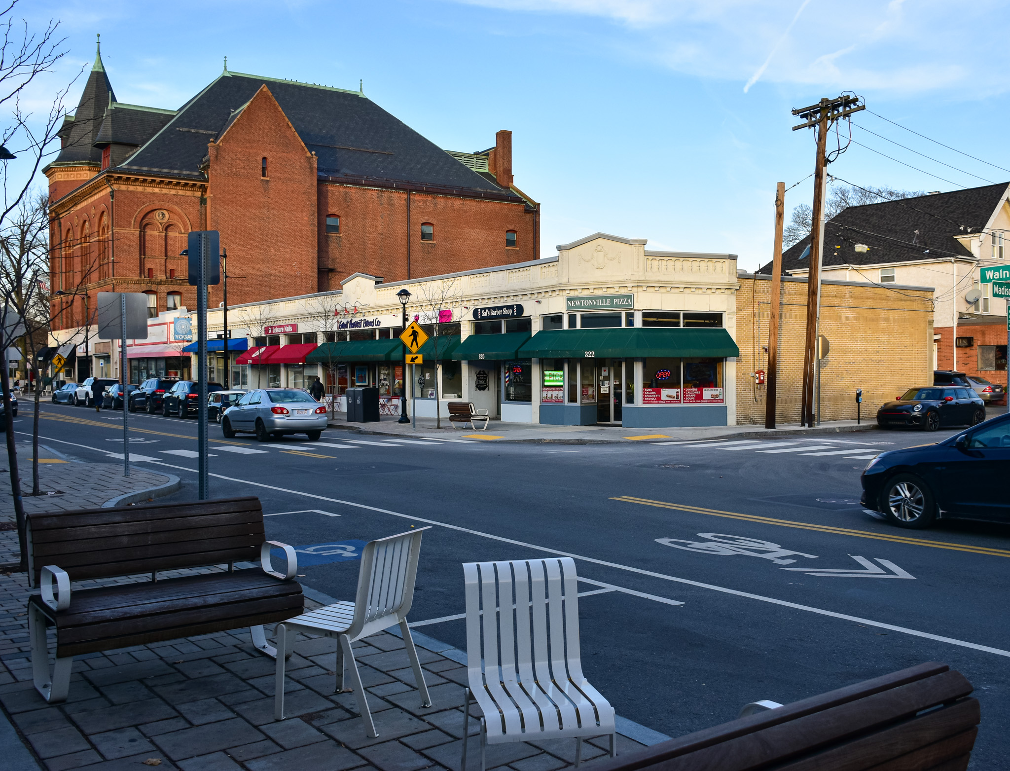
Between the Masonic Temple and Madison Avenue on the east side of the street are located three relatively drab one-story retail buildings. They all date to sometime in the 1920s. I know at some point, the first Newtonville Star Market was located along here. Currently these buildings are occupied by Newtonville Pizza, Sal's Barber Shop, Blossom Nutrition, Great Harvest Bakery, Leisure Nails, YGK Kitchen Cabinets and an empty storefront where once stood a CVS. The pharmacy has since moved to space at Trio Newton. I have heard that a plan has been submitted to the city to build a few stories on top of the CVS for apartments and retail.

(Leisure Nails, Great Harvest, Blossom Nutrition.)

On Madison Avenue, near the corner of Walnut Street, is Phoenix Physical Therapy, which is located in a building that has had a revolving door of tenants over the years.

The building rose in 1925, according to the assessor's database.

Hey, how 'bout a flashback for longtime Newton residents!

Debbie's Petland was located at 330 Walnut Street, next to Village Bank, for many years (the ghost sign shown above is located on another building). By the time I moved to Newtonville, the store was Newtonville Pet. I used to go there for cat food, litter and toys. I also used to take my kids there when they were little, just to look at the fish, birds, snakes, puppies and kittens. That store, which was run by very friendly folks, closed in 2014 after 18 years in business. The space, which is owned by Village Bank, has been vacant ever since. I'm not sure why.

On the other side of Madison Avenue is a similar set of retail buildings, home to Mochiko Hawaiian, which sells fried chicken, bubble tea and other foods; Natural Sense cosmetics; Village Bank; Opticians 3; Title City Barbers; Aji, a Japanese retaurant; and Donut Villa.

(Village Bank, on the left, and Title City Barbers.)

(The former Brewers Coalition space is now occupied by Donut Villa. I really miss the Coalition.)

The west side of Walnut Street looks very much like its eastern twin, with low-slung retail buildings from the 1920s. Tenants on this side of the main drag include Los Amigos Taqueria, Rancatore's Ice Cream & Yogurt, Newtonville Laundromat, Nail It! salon, Brookline Bank, a UPS store, Union Pharmacy, LeDu Thai restaurant and George Howell Coffee.

The last two buildings on this block that I want to highlight are banks. The first one looks like a "bank," while the second one I find much more inviting.

303 Walnut Street "was designed in 1919 for the Newton Trust Co. by the Thomas James Co., a firm specializing in bank designs," according to MACRIS. I guess NTC picked the right firm, but I find this building quite imposing. I suppose that's what most folks want in a bank.

Its neighbor at #305, however makes me feel welcomed.

This bank "was designed in 1938 for the Newton Cooperative Bank by Quincy architect, C.F.N. Rogers," per MACRIS. "Its Neo-Federal style design complements the earlier, Classical Revival style bank next door." Complements the Bank of America building? More like, "makes it look like a less evil version of the Death Star."

I want to close out this post, this look at Newtonville and this entire series with a piece of art.

Painted by Destiny S. Palmer, this bold and beautiful mural graces Philip Bram Way, the plaza and walkway created next to the 28 Austin Street Apartments that rose on a former municipal parking lot in 2019. Once a driveway into said parking lot, Bram Way is a nice oasis in the middle of the bustling village. Folks can sit at tables and chairs sipping coffee or gnoshing on snacks or relaxing with their kids after shopping at Henry Bear's Park, a great toy store that's part of a local chain.

I'm hoping somebody can tell me who Philip Bram was.

As for the artist, Palmer works at Thayer Academy in Braintree. Prior to that, she was an Assistant Professor at Massachusetts College of Art and Design, according to her web site. "Palmer is trained as a painter but her work explores the intersections of painting, history and color, allowing it to blur the lines of painting, sculpture and installation. Palmer has participated in exhibitions at Antenna Gallery, The Colored Girls Museum, Automat Collective, Ely Center for the Arts, Vandermoot Gallery, Landmark College."

I have only hung out on the plaza on a few occasions, for short periods of time. But I know it's popular with high school kids and folks who live, work, shop and eat in the area. When 28 Austin Street was proposed, some Newton residents complained about the loss of a parking lot, the addition of kids to local schools and the possibility for increased traffic. I don't know what, if any, negative impacts this apartment building has had on Newtonville, but I know that it has positively affected the public gathering mojo in the village.

And I love the addition of the mural. One of my favorite trends in recent years of exploring towns and cities of Greater Boston is the explosion of public art across the sides of buildings, the entirety of electrical boxes and even vacant storefronts. These expressions help bring life and color and joy to places. With more development in the planning for Newtonville, West Newton and elsewhere in the Garden City, residents can expect to be wowed with more such artistic statements.

And so I draw the curtains on Newton. I hope you have enjoyed this series, and that you will continue to keep up with this blog and all the other fantastic places I explore. From the bottom of my heart....

Here are the previous posts in the series:

February 4, 2023, "I Seek Newton, Part XIII: Newtonville (Section 2)"

January 28, 2023, "I Seek Newton, Part XIII: Newtonville (Section 1, The Orr Block/Trio Newton)"

September 10, 2022, "I Seek Newton, Part XII: West Newton (Section 3)"

September 3, 2022, "I Seek Newton, Part XII: West Newton (Section 2)"

August 27, 2022, "I Seek Newton, Part XII: West Newton (Section 1: The Barn Redevelopment)"

December 31, 2021, "I Seek Newton, Part XI: Newton Corner (Section 3)"

December 18, 2021, "I Seek Newton, Part XI: Newton Corner (Section 2)"

December 11, 2021, "I Seek Newton, Part XI: Newton Corner (Section 1)"

April 10, 2021, "I Seek Newton, Part X: Newton Centre (Section 3)"

April 3, 2021, "I Seek Newton, Part X: Newton Centre (Section 2)"

March 27, 2021, "I Seek Newton, Part X: Newton Centre (Section 1)"

November 15, 2020, "I Seek Newton, Part IX: Nonantum (Section 3)"

October 29, 2020, "I Seek Newton, Part IX: Nonantum (Section 2)"

September 24, 2020, "I Seek Newton, Part IX: Nonantum (Section 1)"

March 14, 2018, "I Seek Newton, Part VIII: Upper Falls (Section 3)"

March 8, 2018, "I Seek Newton, Part VIII: Upper Falls (Section 2)"

March 1, 2018, "I Seek Newton, Part VIII: Upper Falls (Section 1)"

March 7, 2017, "I Seek Newton, Part VII: Thompsonville"

December 5, 2016, "I Seek Newton, Part VI: Chestnut Hill"

September 26, 2016, "I Seek Newton, Part V: Oak Hill"

June 3, 2016, "I Seek Newton, Part IV: Waban"

March 23, 2016, "I Seek Newton, Part III: Newton Highlands"

September 20, 2015, "I Seek Newton, Part II: Auburndale"

May 21, 2015, "I Seek Newton, Part I: Lower Falls"

A Saturday Skulk Through Southie

From Dave Brigham: I've covered South Boston quite a bit on this blog (see the bottom of this post for links) yet somehow I found more...