Monday, March 27, 2017

The Land of Lincoln

From Dave Brigham:

I've trod across a lot of conservation areas in service of this blog, but I've never seen a sign like that one above. I have to admit, as simple as that sign is, I don't fully understand it. "WALKERS & RIDERS WELCOME," it says. "BUT CONTROL YOUR DOGS!" OK, got you so far. "KEEP OTHER DOGS OUT". Huh?

Located in Lincoln, Mass., the sheep pasture is part of a conservation area that turned out to be quite a bit bigger than I was expecting. A leafy suburb of Boston, Lincoln has many beautiful homes dotting a rather rural landscape. I recently checked out the Silver Hill Bog/Pigeon Hill/Browning Fields area, which is close by the Stony Brook conservation area on the Lincoln/Weston line (see February 17, 2017, "Stone Cold Surprise").

I'd come in search of some stone ruins that I'd seen online while researching the Stony Brook post. I parked next to what's called the riding ring. Lincoln is a very horsey town. I believe the riding ring is a public feature.

(Colorful logs awaiting warmer weather and the chance to serve as obstacles for horse jumping.)

(A small jump.)

(This looks like a decoration, but I have a hunch it's more than that.)

Beyond the riding ring you quickly enter the woods, which is dotted with stone walls. I had no idea where to search for the ruins. I had a feeling which way I needed to go, but I didn't follow my nose right away. I was aware that often when I'm wandering in the woods -- or a cemetery or an old mill town -- I find much more than I thought I would, and something better than my original quarry.

So I wandered through some boggy lands and alongside the sheep pasture. I didn't see any fleecy ewes or rams, or dogs or horses. Hell, I think the only member of the wildlife community I saw was a squirrel. Once in a while I see deer on my outings, but usually it's birds and squirrels.

Eventually I hit a dead end and had to turn back in search of the ruins I knew were in this area. I wandered back through the woods, took a few different paths than I'd walked along on my way in, looking for something -- anything -- to take pictures of. Other than stone walls, and large homes through the trees, I saw little.

As I strolled along I tried to get logical about my search, rather than just walking aimlessly. No more than ten seconds after I thought, "The ruins will probably be on a hill," I looked up through the trees and saw what I'd come for.

This is the Pigeon Hill area, about which I've been able to find exactly zero information.

The stone ruins appear to have been a small house. There is a chimney at one end, a few doors and windows, and evidence of partying.

I'm not sure the era of the structure. There is cement mortar holding some of the stones together. Above is a close up of a nail in the notch of the wood beam you see in the first photo of the structure above.

I'd love to hear from anybody with a good guess as to the age of this place.

Wednesday, March 22, 2017

Anniversary Post #2: My Favorites from 2011

From Dave Brigham:

Welcome to the second installment of my look back at the past seven years of this blog. Launched on March 1, 2010, The Backside of America has published more than 400 posts covering three dozen states, written by more than a dozen authors/photographers.

The first installment in my look-back, "Anniversary Post #1: My Favorites from 2010," covered the first 10 months of the blog. This post will cover the entirety of 2011. Future posts will deal with the years 2012-2016, and with some of the challenges of running this site, as well as exciting changes coming to The Backside of America.

I need to mention that Joe Viger has contributed some amazing photos and fantastic write-ups over the years, but I'll be linking to very few of them in this series. Why? Because Joe -- an amazing photographer who has served as a mentor of sorts to me in that regard, and a great friend I've known for nearly 30 years -- has changed the security settings on his Flickr account so that many of his photos that have run on this blog show up as broken links now. I will instead direct you to his wonderful online portfolio.

Without further ado, here are the highlights, as I see them, from 2011, the first full year of the blog.

I brought my then three-and-a-half-year-old daughter with me to take pictures of a long-abandoned section of Route 128 in Milton, Mass. She danced happily along the moss-covered roadway while I snapped away for my January 24, 2011, post, "End of the Road."

The blog has featured other abandoned roadways, as well as some that were built but never put into use. Search the site....

On January 30, 2011, we published the inaugural post by Kristen Smith, a great photographer who'd been recruited by Joe Viger, one of The Backside's original contributors. "Demolition -- Par for the Course" chronicled the demise of a miniature golf course in New Hampshire.

I was extremely excited by David Burke's February 20, 2011, post, "Lose, Place or Show." This marked the first and, to date, only time the blog has run something about an old horse track. Surely there must be other abandoned tracks like this. Maybe you or someone you know would like to take pictures of them....

I would absolutely love to get inside the former O'Hara Waltham Dial Company in -- where else? -- Waltham, Mass.

On February 27, 2011, I posted some photos and background about this building just over the line from Newton's town dump -- see "UPDATE: What a Dump." I returned a second time for a look at the backside of this backside building. I'll probably post that link in a future installment.

In her March 14, 2011, post "Lost Bomber," Kristen Smith showed readers a World War II-era crash site of a B18 bomber in the woods of New Hampshire. I was absolutely floored by her photos, as well as by the idea that such a site existed.

On March 24, 2011, the blog published the first post by Michael Cevoli. Titled "Working In a Coal Mine," the post featured gorgeous shots from Pennsylvania coal country. I had hoped we might feature a lot more of Cevoli's work, but I believe we only published one or two other of his posts. You can see his work at his web site.

"Mysterious. Odd. Mournful. Ramshackle. Puzzling. Even whimsical. Yeah, I’m talking about those weird little shacks on the side of the road that make you go 'hmmmm.'" That's how Kristen Smith introduced her beautiful shots of abandoned cabins in Vermont, New Hampshire and Montana, in her June 10, 2011, post "Roadside Attractions?"

Discovering new places to explore is great, but I find that when the stories we post here on the blog have a personal angle, I like them best. Mick Melvin went back to his adopted hometown in New Jersey and took photos and wrote about childhood memories in the June 23, 2011, post, "The Gut." Spoiler alert: "As it turns out, the families we met in the Gut will be friends of ours for life," Mick writes.

Folks like those of us here at the Backside of America who enjoy taking pictures of the dilapidated, abandoned and forgotten parts of this country sometimes get accused of exploiting the poor and downtrodden and trafficking in "ruin porn." I maintain that we are documenting the past and, sometimes, providing a forum for reminiscence to those who recall certain places and times.

Still, sometimes I make assumptions about places that I know nothing about.

The Reef was a bar in Waltham, Mass., that closed down several years ago, and has since been replaced by an apartment building. I never went to The Reef, and when I wrote about it in my August 25, 2011, post, "Goodbye Reef, So Long Bill," I was somewhat dismissive, writing, "I picture lots of skinny, old guys wearing tank tops and smoking in and around the door. I hear old country music leaking out the grimy windows. I smell pickled eggs on the bar."

This post received numerous comments -- a rarity for the blog -- from former customers who missed the bar, but also mourned the former owner, Bill. "It might have looked scarey (sic)," one person wrote, "but there where a lot of awesome people who hung out inside."

I learned not to judge a book by its deteriorating cover from those comments.

Mick Melvin made personal connections with his return to a place he once lived. I, too, have profiled a few places in my hometown of Simsbury, Connecticut. The most personal was the ruins of a home that I'd walked through as a teenager, not long after it had been abandoned with every personal possession intact.

The house was torn down decades ago, but I was amazed to see upon my return that there was plenty left behind in the mud. As I wrote in my September 20, 2011, post, "In Search of President Little," "I had no reason to expect that anything would be on the site. I'm not a spiritual guy whatsoever, but I feel like something drew me here to discover the remnants of a forgotten place."

Finally, on November 20, 2011, I published the second of a three-part series about long-abandoned waterworks in and around Newton, Mass., where I live. "History Flows On, Part II" covered the old structures of Cutler Park, specifically the section in the town of Needham, just east of Route 128, and the graffiti-covered tunnel running under the commuter train tracks.

Make sure to check back for the third part, covering all of 2012. Highlights will include photos of the remains of an old boathouse on the Charles River in Waltham; a spooky old barn in New Hartford, Conn.; and the remnants of a World War I-era rifle range in Concord, Mass.

Monday, March 20, 2017

Brigham in Waltham, Part III

From Dave Brigham:

Damn, Waltham, you ain't got no end!

This is the third and final installment of my review of the backside of Waltham, Mass. (see January 5, 2017, "Brigham in Waltham, Part II," and November 9, 2016, "Brigham in Waltham, Part I").

I've written plenty of times about single features of the former mill city, and surely will again. Because I live in the town next to Waltham, and pass through several times a week, I figured I'd gather as many photos and do as much research as I could on the things that interest me. But there's so much!

I thought I was done with this post, but then I thought, "Hey, why don't I give a quick look at the old Metropolitan Parkway site, and the conservation area not too far away on Trapelo Road?

That resulted in many great finds, so that's where I'll start. I'll let you know upfront: there are LOTS of pictures in this post.

I drive by the Metropolitan Parkway every weekday, on the way home from my son's school in Sudbury. The road now leads to an apartment complex, but once was the way in and out of Metropolitan State Hospital, a mental hospital built in 1927 and closed in 1992. I did some mountain biking in the area in the mid-'90s, when most, if not all, of the buildings were still standing. I was dumbfounded and fascinated by the abandonment of so many identical brick structures, but didn't own a camera at the time and wasn't as much into the backside of the world then as I've become in more recent years.

To read about Met State and see some photos of the site, check out this Opacity post. Be sure to scroll to the bottom of the post and click on the links for additional photos, which document both inside and out.

After parking my car, I walked along a path with a stone wall on one side and overgrown brush on the other, and before long I was staring at this building.

I've featured this building before on the blog (see August 23, 2010, "You Don't Have to Be Crazy to Live Here, But It Helps," the most insensitive headline I've ever written....). It was the administration building for the hospital, and sits just steps away from an apartment complex. I figured after six years this place would have been gone.

I have no idea why it hasn't been torn down, although it probably has something to do with asbestos and money. I don't know if there is a plan to demolish it.

As I was working on the research for Met State after taking these photos, I realized that I wasn't quite done with this final installment. You see, I discovered that not too far away from this building sits the cemetery that was used jointly by Met State and the nearby Fernald School. So I had to go back....

Just steps from the parking lot abutting the old admin building, I found this site. It stands just off a side path on the way to the main trail toward the cemetery. These steps don't seem to have been part of the old hospital grounds. There are other older features in this area; not sure what their stories are.

The cemetery features approximately 310 burials from 1947 to 1979, per the sign at the front of the graveyard. The site is split between Protestant and Catholic burials.

In the middle of the cemetery is this altar/shrine.

I found just one grave with a name on it.

After reflecting on the sorrow so many families must have felt knowing that their loved ones not only died at Met State but also were buried in such a way that nobody would know who they were, I set to wandering. I found some remnants of the old hospital's infrastructure.

I also stumbled across this:

This sofa bed must have been pulled out of one of the old hospital buildings. This whole area has a lot of paths, some of which are obviously frequented by mountain bikers. I suppose those who hang out in this area might have chilled on this couch at one point. I didn't see evidence of partying in the woods, but I'm sure it goes down.

With so many paths to choose from, I selected one that I knew would take me toward the site of the former Gaebler Children's Center, a facility that once stood on the other side of a hill from Met State. I direct you again to my August 23, 2010, post "You Don't Have to Be Crazy to Live Here, But It Helps," which is about both the Met State admin building and the former psychiatric institution for adolescents. Read the comments under the post; they are heartbreaking.

There are no more buildings on the Gaebler site, which may get developed at some point. I did find these old wagons, which may have been used for hay rides.

I then made my way up the hill toward the water tower, which I recalled from my mountain biking days.
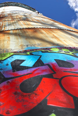
Finally, on my way back to the car, I stumbled across what appears to be an old chimney or outdoor cooking area, near the stone steps I'd seen on my way in.

This area of Waltham was once quite different. Rural and remote but not too far from Boston, the sites along Trapelo Road -- Met State, Gaebler Children's Center and the Fernald School, which I mentioned in part two of this series -- housed the mentally ill and other children and adults who society deemed unfit to live in their own communities. Now these sites have been commercially developed or turned into conservation land.

A little further west along Trapelo Road once stood Middlesex County Hospital, which operated from the 1930's to 2001. This site, too, was developed into condominiums. I didn't get a chance to check out that area before the hospital was torn down, but I recently explored a great wooded area just down the hill that was an unexpected suburbex goldmine.

James Falzone Park is a soccer field with a secret. After driving by this recreation area dozens of times, I realized there was a path leading into a large wooded area that surrounds this place on Trapelo Road. Research ahead of time yielded no clues as to what lay in this conservation area, but I had a hunch. That suspicion paid off bigly, as Donald Trump would say.

If an old pump house and yet another stone wall were all I found in the Falzone conservation area, I would've considered this little jaunt a success. A mild success, but still something worth doing. But then I saw this.
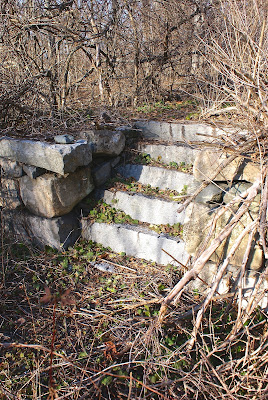
God that's a beautiful site, isn't it? While many people walk past these steps and wall and think little or nothing of them, this is the kind of ruin that sets my heart racing. I have so many questions: How old is this ruin? What did the house look like? Was it a farm house? Who lived here? How long has this place been abandoned?

The front yard of what I'm assuming was a farm house is now a soccer field. A few steps west down the path is another remnant.

There was a community of sorts here. There may be more evidence of homes and other buildings on this section of land on the Waltham/Lexington line. I plan to get back and explore some more.

While nobody lives in the houses I stumbled across, I did find evidence that people are living or at least hanging out here.

The remainder of this last installment will focus on ghost signs, a mural, some old commercial properties and a cool map.

This great map is located at the corner of Harvard and Main streets, on the outside of the former Waltham Super Market, which is now Hannaford Supermarket. Landmarks on the map are Waltham City Hall (c. 1926), Waltham Super Market, Waltham Hospital (c. 1887), a sanatorium (which must be Met State), roadways, rivers and ponds, wooded areas (including a Girl Scout camp that still exists), Brandeis University (c. 1948) and the Boys Club of America (c. 1937).

The artist is the late Leon Nigrosh, who grew up close to Waltham, in Cambridge and Belmont. Nigrosh published ceramics textbooks as well as art reviews for numerous publications.

Located a short distance from the Hannaford, Bubbles Laundromat has replaced its sign since I snapped this picture.

Quick Stop Variety is located on Main Street, not too far from Hannaford, in a cool old building that also houses The Common Cafe.

Further east on Main Street, on the corner of Newton Street, sits the shuttered A to Z Auto Service station, next to an empty lot where Stephen's Liquors once stood. This corner has been neglected for quite some time now but I assume something will get developed here before too long.

Located on the back wall of Michael J's Pub ("Waltham's Best Dive Bar"), this Coca-Cola ghost sign may at one time have been larger. I'm happy the building's owner kept it. Side note: I once drove past this bar and laughed my ass off at the sandwich board sign out front that read, "Soup of the Day -- whiskey!" I haven't seen the sign since, so perhaps the city told Michael J's to take it down.

For the final segment, I move on to Moody Street. Known in recent years for its wide variety of restaurants, Moody Street was once home to department stores, shoe stores, bakeries, hardware stores and some adult bookstores. For a look at the street's past, check out this Brand New Watch blog post.

The sign for Amelia Upholstery Shop caught my eye because that's my daughter's name. I then spotted the faded sign for Spencer Shoes, which is name-checked in the Brand New Watch blog post. Spencer is no longer open, and I don't believe the upholstery shop is either, since the longtime owner, Joseph Amelia, died last year.
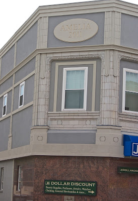
I also spied the name "Amelia" on this building on Moody Street. A little research online brought this article to light. This building is owned by Ralph Amelia, brother of the late Joseph. This building once housed a beauty school upstairs, but now comprises seven apartments.

When walking through a parking lot on the backside of Moody Street, I hardly expected to find this amazing painting along the driveway back out to the shopping and restaurant area.

This girl is just one of the beautiful faces depicted by artists Caleb Neelon and Katie Yamasaki. For more on the mural, which was completed in September 2011, see this Brand New Watch article.

See, not everything on the backside is rusty and falling apart.

Along another side street I found this ghost sign for a fountain shop. You can make out part of the Coca-Cola logo.

Finally, the backside of a building on Felton Street, which is just off Moody.

A post-and-beam warehouse/industrial space, 22 Felton Street was home way back when to J. Cushing Company, a grain distributor. You can see the letters "AIN" up there.

Well, that's it for now. I'm sure to post more about Waltham in the future, but this should hold you over for now.

Tuesday, March 14, 2017

Working Our Way Around Winthrop

From Dave Brigham:

I've happily traveled to Winthrop, Mass., several times in the past few years to help my son, Owen, spot airplanes landing at Logan Airport, and, more recently, to hunt for Pokemon (see February 27, 2015, "Digesting Deer Island"). We've been to Deer Island (where I took the above photo) and Coughlin Park, but just recently realized that there's something called "the center of town." Recently we checked out that little downtown, as well as more of Deer Island and the Point Shirley beach neighborhood. Here's what I found.

(Samuels Pharmacy was established in 1952, according to the Better Business Bureau, and incorporated in 1983. Not sure how old this building is, but it certainly pre-dates 1952.)

(This facade is on the same block as the pharmacy, and might be an old entrance to the back of the shop.)

(This amazing place is the old Winthrop Theatre, which was built in 1914. There is now a gymnastics academy there and probably other businesses.)

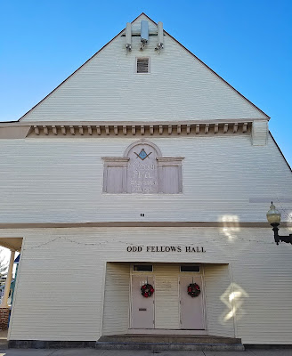
(Masonic Temple / Zenith Lodge #42, International Order of Odd Fellows. According to an article I found online, Freemasons and Odd Fellows are not affiliated with each other, despite their numerous similarities, such as the symbols and initiations they use, and the regalia they favor. This temple was built in 1892.)

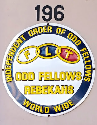
(Detail of Masonic Lodge/Odd Fellows Hall. The Daughters of Rebekah was initially a female-only auxiliary of the Odd Fellows, but now admits men.)

Just down the street from the temple is Sudden Impact, a video game and toy store.

(Urkel doll and other stuff at Sudden Impact.)

(The Wadsworth Building looks great. A longtime Winthrop resident bought this building and others in town over the last several years, and rehabbed many of them.)

(Cool marker in a nearby cemetery.)

Walking a few blocks out of the small downtown, following Owen and one of his buddies as they sought out Pokemon, I saw this index card-sized metal marker on a sidewalk.

A search for the name "FJ McQueeney" online brought up a printer in Boston listed in "Leading Manufacturers and Merchants of the City of Boston," in 1885. No idea if this is the same guy. I've never seen a marker like this anywhere else.

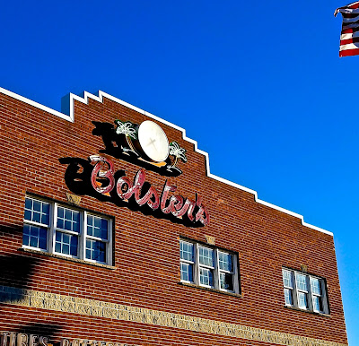
Outside the quaint town center I stumbled across this cool sign.

The sign appears to be newer, but I love it anyway, especially the palm trees that frame the clock. Bolster's is an auto and marine service company. I was unable to find out anything about the company or the building, but I'm guessing the building dates to at least the 1930's, and perhaps the company does too.

On the way to Deer Island, which is home to the second-largest sewage treatment plant in the United States as well as some nice walking paths, we passed through the Point Shirley neighborhood. The area is on a spit of land between Boston Harbor and the open ocean, and has a Cape Cod vibe going.

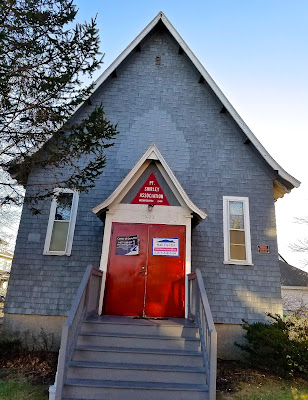
(Incorporated in 1944, the Port Shirley Association hosts functions in its quaint hall.)

(Directly across the street from the Point Shirley Association sits Holy Rosary Catholic Church.)

(Just before you hit Deer Island, you'll see a small beach.)

(There are all sorts of rocks, concrete slabs and other oddities used to build beach walls.)

(The remnants of a pier just below Deer Island. No longer separated from the mainland, Deer Island has over the centuries served as a prison, a hospital, an almshouse, a sewage treatment plant and, more recently, a recreational area.)

Cape Cod Lobster Joint Can't Claw Its Way Back to Life

From Dave Brigham: Lobster shacks and Cape Cod go together like Cape Cod and lobster shacks. But the unimaginatively named American Lobs...