From Heidi Waugaman-Page:
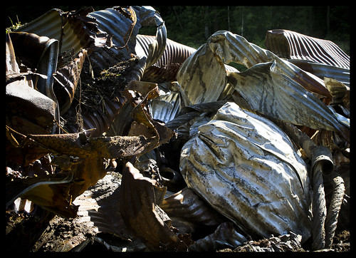
Refuse from road work done after the flooding that washed many roads away in Ashland, NH, in 2008.
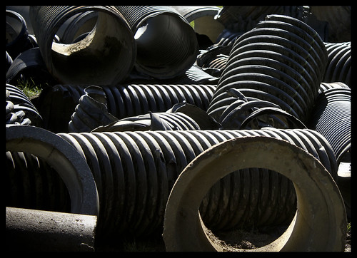
From Heidi Waugaman-Page:
Refuse from road work done after the flooding that washed many roads away in Ashland, NH, in 2008.
From Dave Brigham:
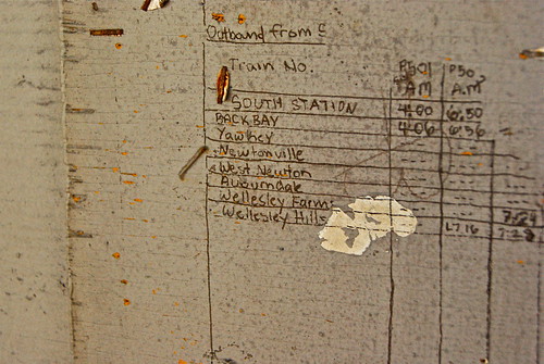
I took my son, Owen, for his first ride on a commuter train recently. As we waited at the station, I noticed this. Seems there used to be a handwritten schedule tacked here, and the writing pressed through to the board above the bench I was sitting on. Or maybe somebody just wrote it right on the board.
Round trip cost: $14.00 (if I'd known enough to buy a round-trip ticket when I first got on, it would've been cheaper). You'd think for that amount of money, I'd get a full schedule, laminated and handed to me on a silver platter.
I kid the Massachusetts public transportation system, but I love it.
From Dave Brigham:
Ever since I discovered the remnants of a torn-down house in my hometown 15 months ago (see September 20, 2011, "In Search of President Little"), I find myself looking at patches of woods wherever I go and wondering what archeological wonders are buried there, perhaps never to be discovered.
Even when I go on excursions to places that I know I can learn more about later by researching online, I always think, "What else is hidden around here that's been forgotten?"
Sometimes I have the opposite problem: I know that a site contains a certain element that I want to explore and take pictures of, and I can't find it. This happened to me recently.
I set out toward the former Fernald School in Waltham, motivated in part by a comment at this blog about a post about an abandoned factory in the Watch City (see February 27, 2011, "UPDATE: What a Dump").
Long story, short: Fernald is still in operation, albeit in a limited capacity. As such, there are people around and I stopped at the bottom of the driveway and decided against snooping around. I'm not an urbex guy, mostly for the reason that it wouldn't look good if my two kids were waiting at school for me to pick them up and saw me ride by in the back of a police car, having been arrested for trespassing.
Here's what other people have documented from the site.
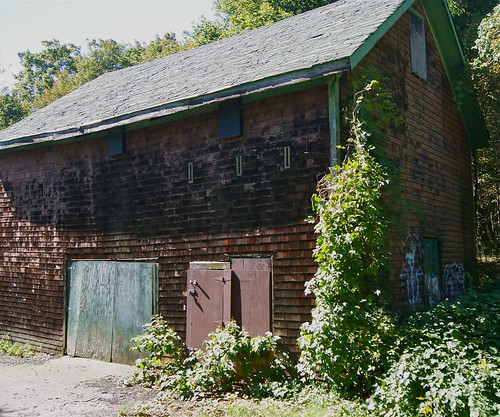
After leaving Fernald, I doubled back and looked through the woods at an old house or barn. I took the next left turn I could, and *snap* just like that, I was pulling into the parking lot for the Beaver Brook Reservation in Belmont.
I looked at the map at the beginning of the small network of trails, and saw two words that got my heart beating a little faster: "mill remains." Yes, I know that's pretty nerdy, but obviously if you're reading this blog, you share my desire to discover hidden pieces of the past.
I set out first to snap some pictures of the building I'd seen from the road. I found it without any trouble and took a few shots:
Then I set out on a few other trails, but couldn't find any mill remains. I went back to the map, consulted with a fellow visitor and hit the trail again. Still, no luck.
I took a third look at the map and finally got a pretty good idea of where to look. But evidently the site where mill once stood was overgrown and there wasn't much to see anyway. I looked and looked in the underbrush, but couldn't see any evidence of a structure or ruins. The mill in question was a fulling mill, in which wooden hammers are employed to clean cloth.
Here's somebody's else's write-up about their own effort to find the mills (apparently there were a few on site from the 1600's to 1800's).
Maybe I'll go back this winter once the leaves have fallen and see if I can get a better look.
From Dave Brigham:
I spent a recent Sunday in Connecticut with my brother and sister, taking our parents our to lunch for their 55th wedding anniversary. We had a nice time catching up with each other. We realized that the five of us hadn't had a meal together (without spouses, kids, aunts, uncles, cousins) in a few decades.
On my drive back to Massachusetts, I realized I had time to check out some of the potential Backside sites I'd noticed in recent years along Route 84. I was, of course, excited by this prospect.
The first place I stopped was a former sports complex in Vernon, CT. At one time, the facility included multiple softball fields that you could see from the highway. I'm not sure what else was there.
In recent years, though, the place went out of business, and nature has taken over. From the highway, you get great views of weed-choked fields with dugouts seemingly randomly placed in the middle.
Unfortunately, when I got off the exit and drove past the place, I found no good vantage points to take pictures. Bummer.
The next place I had in mind is a vacant filling station and garage in Holland, CT, just south of the Massachusetts border. The property is fairly well kept and easy to access, but the "No Trespassing" signs and the presence of a house directly across the street from it kept me out. Call me chicken if you want.
With my time getting short, I decided to get off just a few miles up the road in Sturbridge, before getting on the Mass. Pike and completing my trip home.
The town was hit by a tornado in June 2011, and on drives through there on Route 84 over the last 16 months, I'd noticed a lot of damage. One of the most obvious targets was a Days Inn on Route 15, which parallels the interstate.
I drove past the motel, but once again was deterred by "No Trespassing" signs and the feeling that I wasn't really documenting the Backside, as much as the Downside of Nature.
Here's a video somebody took the day after the tornado, focusing on the motel and the immediate environs:
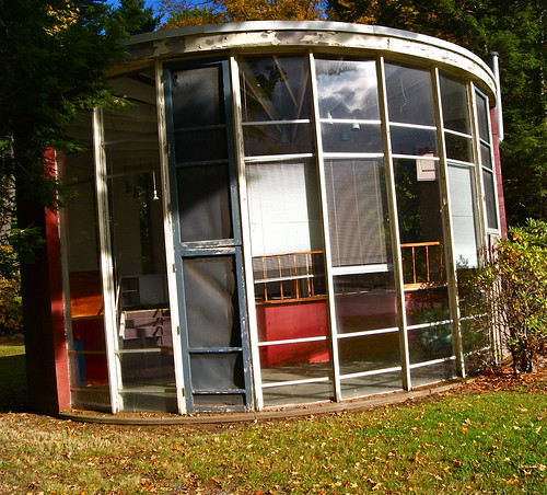
On my way to check out the Days Inn, I'd noticed an attractive stone building with a "For Sale" sign on it, and an odd, round building at the back of the parking lot. So I doubled back for a second look.
The stone building, as it turns out, was once a Hebert Candies retail store. At the back of the building's parking lot stand two buildings: one that looks like a cottage, or the office for an old motel; the other that looks like this:
In between the buildings stands a large wooden sign with a map of Sturbridge highlighting all the tourist destinations, the most well-known of which is Old Sturbridge Village.
I approached the round building cautiously, unsure if anyone was inside, or whether anyone in either of the two buildings might come out to ask me why I was trespassing. But as I made my way around the little building, I encountered no resistance.
With the sun directly behind me, I found it hard to get a good look inside. Here's the best shot I could get:
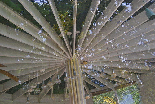
I was surprised by the intricacy of the beams and lights. Otherwise, there wasn't much of note in the building. I noticed a chalk board and some boxes and random pieces of furniture. I thought perhaps it had been used recently as a preschool or an office.
I couldn't find out anything online, but I entered into a dialogue with a helpful guy named Wally, who runs the Sturbridge Common blog. He said the place dates to the 1960's, but he didn't know anything more about it.
He asked his readers if they had any clue about the place, and then put up a post about how he thinks the town of Sturbridge or local Chamber of Commerce should buy the site and turn it into a gateway to the town, complete with an information center, gift shop, a restaurant, and a headquarters for Trek Sturbridge, which could offer trail maps, outdoor books, canoes and supplies.
He envisions the round building as a museum featuring Sturbridge history. This post set off quite a lively discussion on the blog about other ideas for the site. Amid all of this, one commenter yielded a bit of information about the round building.
"Many years ago the round building housed what I seem to remember as a place that displayed and sold unusual objects. I think there were exotic, ethnic masks and other interesting artsy things in there."
This person suggested the building be used for a similar purpose if the gateway idea ever came to fruition.
This is one of the things I love about doing this blog: finding out-of-the-way places, learning a bit about their history, and connecting to a larger community.
From Pete Zarria:
I just liked the look of this place in Truth or Consequences, New Mexico. I walked in to a chilly reception....
From Dave Brigham:
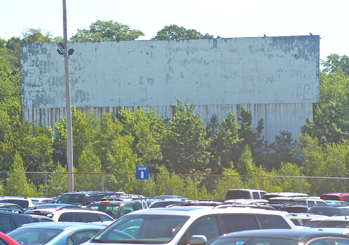
Visible from Route 93 in Braintree, Mass., one of the two screens at the long defunct South Shore Plaza Twin Drive has long intrigued me. I finally got around to taking a look, but I couldn't get any closer than this because there's a pay-to-park lot for bus service to Logan Airport there now.
Closed in 1986, the theater had two screens, at least one of which used to entertain drivers passing by on the highway.
I loved going to drive-ins during high school and summers home from college. I saw such fine fare as "Senior Snatch," "Eager Beavers," "Last House on the Left" and "Slumber Party Massacre."
The last time I went to a drive-in movie was in the summer of 2002, in Wellfleet, Mass. We saw an odd double bill of "Signs" and "Austin Powers."
For more on old drive-ins, see April 24, 2010, "Cars, Flicks & Weiners."
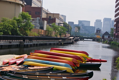
From Dave Brigham:
This is another one that falls into the category of Places That I've Passed Countless Times But Never Really Noticed.
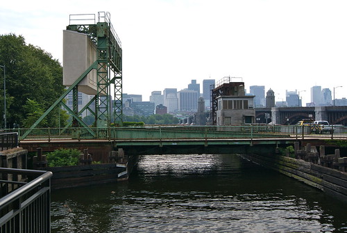
Broad Canal in Cambridge, Mass., is a shadow of its former self. Once part of an extensive system of waterways, the canal now extends just a short distance from the Charles River near Kendall Square.
From Wikipedia:
The canal began in 1806 when Henry Hill, Rufus Davenport, and others laid out a canal system in the land and tidal flats along the Charles River. Broad Canal was dug before 1810, and 80 feet (24 m) wide from the low-water mark to Portland Street. In 1874 the lower part of the canal, between First and Third Streets, was 100 feet (30 m) wide. Connecting canals ran through much of today's East Cambridge.
No visible trace remains of that system, and extensive landfills have removed all remnants of Cambridge's seaport docks and wharves. Broad Canal's truncated remnants can now be found just north of Broadway, entering the Charles River immediately north of Longfellow Bridge.
I found out about the canal while doing a Google search, scanning the map for a waterfront location in the Boston area to do some Backside work.
I spied the words "Broad Canal Walkway" on the map and realized it was a spot I'd driven by numerous times on the way to and from various points, including the Museum of Science, the CambridgeSide Galleria and baseball games in Charlestown.
The walkway is hard by the massive Kendall Cogeneration Station. I saw two small boats tied up along the stone wall that defines the border between the canal and the power plant.
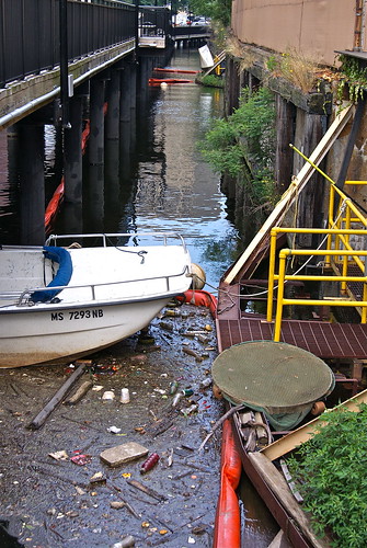
These wharf pilings are silently elegant in their quest to defy the modern world.
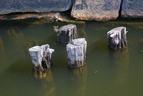
But the modern world, alas, presses in from the end of the canal.
Thanks to Backside contributor Heidi Waugaman-Page for pointing us to this great story and photo set, "New England's Most Haunted Asylums."
From Dave Brigham: I've danced around Boston's Egleston Square quite a bit over the years I've been publishing this blog. I...


