Showing posts with label conservation area. Show all posts

Saturday, October 22, 2022

Revisiting an Old Rifle Range, Testing Out a New Concept

From Dave Brigham:

I've been thinking for years about doing some Backside field trips with friends, family and any other interested parties. In the early years of the blog, when I had a handful of regular contributors, we would discuss meeting somewhere to make photos together, but I never made that happen. For the most part when it comes to Backside treks, I am, like Lenny Kosnowski on "Laverne & Shirley," a Lone Wolf.

There have been a few occasions when I shot photos for this blog while hanging out with other people: on my 2016 visit to a long-abandoned church in East Granby, Connecticut, I was accompanied by my mother; during a 2019 family vacation in Seattle, I annoyed my wife and kids by lagging behind while shooting photos in Pioneer Square; and in the summer of 2019, I strolled Boston's Fort Point neighborhood with a reporter and photographer from the Boston Globe for an article they published about ghost signs.

Recently, I began working to make my vision for field trips a reality. In the short term, I am planning on a few excursions to locations I've visited previously, inviting along anybody who's interested. Depending on how I do with this concept, I may look to make it more of an official venture, offering guided tours with history of the sites, and perks for those who join.

As you may have figured out by the video at the top of this post, I recently conducted my first "field test." I put out the call for any and all who wanted to check out the Old Rifle Range in Concord, Mass., which I first trekked through 10 years ago (see December 4, 2012, "Concord, Part I: Old Rifle Range").

I'd made a list of prospective sites to revisit, and figured the World War I-era range was a good place to start, as it's an easy hike, good for humans and dogs alike, and features the type of remnants one doesn't usually come across in the woods of New England.

When I wrote about the range in 2012, I wasn't sure exactly how the set-up worked. A commenter on the post cleared it up for me: "The metal frames/gears were protected by the concrete, which also protected the soldiers manning the targets. They lifted the targets above the concrete."

I was joined on this hike by my friends Jay and Amy, their son, Henry, and their dog, Bernice. I also had my dog, Trudy.

It was great having them along for the obvious reason of friendship, but also to discuss things about this area that hadn't occurred to me on my first visit. Jay pointed out a few spots, large impressions in the side of the hill on the south side of the site, that may indicate where small buildings once stood. We speculated that there may be more range-related stuff in the heart of this conservation area than meets the eye.

We also learned from a fellow hiker that there is quite likely a coyote den here, as this woman has both seen and heard the canis latrans at the Old Rifle Range.

I hope to fit in one more Backside Adventure before the snow flies (although I certainly explore in winter, weather depending), so keep your eyes peeled to my Facebook page and to this space for updates on that.

Saturday, March 5, 2022

La Salette Park Is No Apparition

From Dave Brigham:

La Salette Open Space in Bloomfield, Connecticut, checks many of my boxes:

Cool place to hike? Check.

Scenic views? Check.

Overgrown and somewhat dilapidated barns and outbuildings? Check.

Beautiful old stone house that you can't go in? Who put that on the list?!

History that includes farming, tin-making and a retreat for a Catholic group that named itself after a town in the French Alps where Blessed Mother Mary allegedly appeared to two children in 1846? Check-ity check!

I stumbled across this 140-acre property on Google Maps while searching for someplace close to my mother's house in Windsor to explore on a recent visit to the Nutmeg State. It was everything I'd hoped for, and more.

Let's start with that fantastic house that you can't enter (although that may change in the not-too-distant future).

Built of traprock in 1834, this place is known as the Oliver Filley House. "The floor plan is unusual, consisting of two intersecting wings," according to Wikipedia. "The primary living quarters were in the west wing. Filley's decision to build a stone house was partly motivated by the desire of his son, but he was also aware that a stone house was becoming a status symbol in the area. It would become the third stone house in Bloomfield, following a house built two year[s] earlier by David Grant, and one built a year earlier by Francis Gillette."

Oliver Filley, Jr., inherited a previous house and some land at age 12 upon the death of his father, Wikipedia continues. He acquired more land and added buildings during his ownership. Filley started a tinsmith business in 1806, and expanded that operation to Elizabeth, New Jersey. He built this house for his son, Jay.

To learn more about the house, the Filley family and the efforts to upgrade the property since the Town of Bloomfield took over the site, check out this document.

The Filley family owned the property only until 1849, when the estate of Oliver Filley, Jr., was settled. The site changed hands a few times over the next five years, with Samuel Pinney buying it in 1854, according to the Wintonbury Historical Society. In 1913, the Pinney family sold the property to the La Salette Missionaries, which operated a college in nearby Hartford. "The house and property was first used as a summer home or country villa for those La Salettes living in the Hartford House, a spot for excursions and picnics during the school year or vacation days," per the missionaries' web site. "The first general outing for the entire College to the new property was held on April 14, 1914 — and it created quite a stir and plenty of excitement in the town of Bloomfield. In 1916 the La Salettes broke ground for a $40,000, three-story brick building east of the Filley House. The 82-by-62-foot structure accommodated 50 students and was called the Novitiate of the College of La Salette."

When I told my sister, who lives in West Hartford, about my trip to this park, she recalled seeing what I believe what was the former La Salette dorm in prior years. The building is no longer standing. As you'll see below, the buildings that remainn on the site are in various states of dilapidation.

Eventually, the La Salette community turned their farming hobby into a self-sustaining business. "[B]y 1940 the farm was self-sufficient, and the novices were an integral part of this reality. In addition to farming, the La Salettes grew and sold produce, operated a dairy farm, raised livestock, slaughtered their own cattle and pigs. They were well-versed in plumbing, carpentry, electrical wiring, bricklaying and cabinet-making. They built their own swimming pool."

A swimming pool - I love it!

So just what the heck are novices? What is a novitiate?

A novice is a person who is in training, so to speak, to become a full-fledged member of a religious order (priest, nun, monk). A novitiate is both the building in which these trainees live, and the time during which the novices are on probation before taking their vows.

The missionaries closed this facility in the 1970s, due to dwindling enrollment in its novice classes. The group moved its novitiate to Altamont, New York. The La Salette organization, which is named for a "small hamlet" in the French Alps where in 1846 the Virgin Mary is alleged to have given her "message of reconciliation" to two young children, maintains a shrine in Attleboro, Massachusetts.

The La Salette organization eventually sold the farm. In 1992, the Town of Bloomfield purchased the site from Milton Levine (I'm not sure if Levine acquired the property from the La Salette folks). In 1993, the Town signed a 99-year lease for the house to the Wintonbury Historical Society, which has completed some renovations on the house.

Of all the buildings on the Bloomfield property, the house is by far in the best condition. But I was more intrigued by a small outbuilding along the main driveway.

I thought perhaps this was once a farm stand, or even a ticket booth for events held at the farm. But, as I learned from some Wintonbury Historical Society documents I found online, this little hut is a well house. I wasn't sure exactly what a well house is, so, crazy as this might seem, I searched on Google for more information. I came across the Into the Woods blog, which has since become a favorite. "A wellhouse was a common outbuilding in the days before electricity," according to the blog. "The well itself, with a windlass and bucket for drawing water, generally was near the wellhouse door."

Having grown up in a town -- Simsbury, which abuts Bloomfield -- that's still dotted with old tobacco barns, I have a certain affinity for these old farm structures (see this post, as well as this one, also this one, and this 'un here). So I was psyched to see some wonderfully decaying samples here.

(I wasn't expecting to see graffiti here.)

(Awfully tempting.)

(This was a workshop of some sort.)

(I'm proud that I knew this is an old corn crib.)

(It was like that when I got here.)

Could the pile of bricks below....

...have once been part of this ruin?

Perhaps. I just love this relic. A new storage area has been fitted into the old structure.

I'm guessing this is where supplies for the adjacent community garden are stored.

OK, let's get to the open space!

While I was certainly very interested in seeing the wonderful old stone house on this property, as well as the falling-down barns, I chose this site to explore because I needed a little fresh-air walkabout. I knew from a write-up at the excellent CTMQ blog ("Destroying the myth that there is nothing to do" in Connecticut) that La Salette offered views of downtown Hartford, as well as some nice paths through both active and former growing fields.

(The clouds obscured the Hartford view a bit.)

I enjoyed seeing Heublein Tower, which sits in Talcott Mountain State Park. As a kid, I climbed the mountain many times with my family. I also loved watching hang gliders soar above the ridge while I played baseball or football on the school field next to my house. I haven't climbed to the tower in probably 20 years.

The property connects to the Wintonbury Land Trust's Hawk Hill property, which I didn't check out. A nice older couple walking their dogs told me that's also a great site, and that it features at least one old barn.

(A frozen pond at the bottom of a hill, near a housing development.)

(I'm not sure what this structure used to be. Perhaps another corn crib?)

The site is still actively farmed, which I was happy to see.

I'm guessing this is a corn field. I don't know who does the farming, what types of crops they work, or where the produce is sold. Perhaps at nearby Wade's Farm Fresh, which traces its roots back to a dairy farm established in 1919.

For more about Bloomfield, check out:

June 2, 2018, "Three Blessings and a Curse"

December 29, 2016, "What's Auers is Yours"

Wednesday, February 19, 2020

Bucking Around the Sears Land

From Dave Brigham:

I love to walk in the woods. Always have, always will. If there are cool bridges, stone walls, old foundations and other treasures to stumble upon, all the better.

Recently I explored the conservation area in Weston, Mass., known as the Sears Land. This wooded acreage abuts the rail trail I wrote about last year (see March 24, 2019, "Weston By Musket and Sextant"). When I learned that this peaceful spot had cellar holes and remnants of a factory, I knew I had to check it out. Here's what I found.

I haven't been able to determine when the Sears family donated the 89 acres that make up this conservation land. I'm assuming these folks are descendants of Horace B. Sears, who "has been called 'the Town’s greatest benefactor,' as he made substantial contributions to the new Town Hall, Town Green, beautification of the center, and other improvements made during the early 20th century," per the Town of Weston web site.

The property stretches from Church Street to the west to Weston Station Pond to the east, the Mass. Central Rail Trail to the north to Crescent Street to the south.

(View of the rail trail from the Sears Land.)

Accessible via the rail trail or Crescent Street, the property includes the Melone House, which was once owned by Italian immigrant John Melone, who worked for the Sears family. The house (date of construction unknown, but it's old) serves as the headquarters of Land's Sake, a non-profit farming, education and land preservation group, and includes related outbuildings.

My interest, however, lay in the vestiges of industry that dot the landscape. While researching the above-linked post about the rail trail, I found a video someone made of a tour of the Sears Land. In that footage, those walking through the woods talked about ruins of an old mill, among other things. That video seems to be have disappeared from the Internet.

So I rolled up the long driveway, parked my car and started poking around.

I opted to follow a path just to the right of the Melone House that was just too inviting to ignore.

At the beginning of the trail I spied some old farm machinery.

Ambling along I saw plenty of stone walls. What is about them that I find so comforting?

I guess it has something to do with the fact that they're often nestled comfortably in the woods, covered in nice blankets of moss and lichens, reminding me of their past as property markers and of how they'll be here long after I'm gone.

There are other reminders of human intervention along the paths.

The most impressive man-made structure is Lee's Bridge, which was erected in 2013 in remembrance of Lee Cohen, a long-time Trustee of the Association, according to the Weston Forest & Trail Association web site.

(Lee's Bridge; wish my photo were better.)

"OK, what about the old mill or factory remnants I read about?" I asked myself as I enjoyed a beautiful fall day.

Crescent Street, which curves gently for a short distance along Boston Post Road (Rte. 20) in the shape of its name, was settled by colonists hundreds of years ago. Farms, of course, were the first businesses to be set up, followed by taverns and mills, per this Town of Weston web page.

From the town's web site: "Three Mile Brook....which runs just north of Crescent Street and eventually joins Stony Brook, provided the power for mills which contributed to the development of the homes along this section of the Country Road," which I believe refers to Boston Post Road. The first mill began operation around 1743, according to the town.

Other mills followed, and "the remains of a dam, a millpond, and a canal for directing water from 3 Mile Brook" exist on the Sears Land. "Large water wheels to power machinery were constructed here, and evidence of the supporting structure can still be seen." I saw some evidence of something, but I'm not sure exactly what.

(This to me looks like a foundation of some sort, or perhaps a supporting structure for a water wheel.)

(This seems too low to be a typical stone wall. Again, perhaps part of a foundation or supporting structure.)

"In 1830, Samuel F. H. Bingham from Concord bought mill rights on the 3 Mile Brook and purchased land on what is now Crescent Street. About 1838-1839, Brigham (sic, I swear) built the home at 39 Crescent Street. He also established a factory in the area behind this residence. Bingham made machinery for the manufacture of heavy woolen goods and invented the Bingham cheese and butter drill, a highly successful item which apparently was in great demand," says the Weston site.

Subsequent factories on that site and nearby produced clocks, chairs and window and door screens, per this Wicked Local Weston article.

Although I didn't find any "big moment" backside sites, I did enjoy scrambling around the remnants there. I love learning about places like this that once housed industry, and which now have returned to nature. Weston is known these days as one of the most exclusive towns in Massachusetts, with the median home price of $1.47 million ranking it in the Top 5. While most of the mills and factories that were located on and around the Sears Land were likely fairly small, there was one factory in Weston that was quite large.

"The Hook and Hastings Co. organ factory was located on Viles Street near North Avenue from 1889 to 1935," per the above-referenced Wicked Local Weston article. 'It was the largest and most important industry in Weston’s history. During that time, church and concert hall organs were shipped by rail all over the country. Power was supplied by steam." In 2017, I wrote about the area where the factory once stood (see June 23, 2017, "A Walk Through Weston's History").

Monday, March 27, 2017

The Land of Lincoln

From Dave Brigham:

I've trod across a lot of conservation areas in service of this blog, but I've never seen a sign like that one above. I have to admit, as simple as that sign is, I don't fully understand it. "WALKERS & RIDERS WELCOME," it says. "BUT CONTROL YOUR DOGS!" OK, got you so far. "KEEP OTHER DOGS OUT". Huh?

Located in Lincoln, Mass., the sheep pasture is part of a conservation area that turned out to be quite a bit bigger than I was expecting. A leafy suburb of Boston, Lincoln has many beautiful homes dotting a rather rural landscape. I recently checked out the Silver Hill Bog/Pigeon Hill/Browning Fields area, which is close by the Stony Brook conservation area on the Lincoln/Weston line (see February 17, 2017, "Stone Cold Surprise").

I'd come in search of some stone ruins that I'd seen online while researching the Stony Brook post. I parked next to what's called the riding ring. Lincoln is a very horsey town. I believe the riding ring is a public feature.

(Colorful logs awaiting warmer weather and the chance to serve as obstacles for horse jumping.)

(A small jump.)

(This looks like a decoration, but I have a hunch it's more than that.)

Beyond the riding ring you quickly enter the woods, which is dotted with stone walls. I had no idea where to search for the ruins. I had a feeling which way I needed to go, but I didn't follow my nose right away. I was aware that often when I'm wandering in the woods -- or a cemetery or an old mill town -- I find much more than I thought I would, and something better than my original quarry.

So I wandered through some boggy lands and alongside the sheep pasture. I didn't see any fleecy ewes or rams, or dogs or horses. Hell, I think the only member of the wildlife community I saw was a squirrel. Once in a while I see deer on my outings, but usually it's birds and squirrels.

Eventually I hit a dead end and had to turn back in search of the ruins I knew were in this area. I wandered back through the woods, took a few different paths than I'd walked along on my way in, looking for something -- anything -- to take pictures of. Other than stone walls, and large homes through the trees, I saw little.

As I strolled along I tried to get logical about my search, rather than just walking aimlessly. No more than ten seconds after I thought, "The ruins will probably be on a hill," I looked up through the trees and saw what I'd come for.

This is the Pigeon Hill area, about which I've been able to find exactly zero information.

The stone ruins appear to have been a small house. There is a chimney at one end, a few doors and windows, and evidence of partying.

I'm not sure the era of the structure. There is cement mortar holding some of the stones together. Above is a close up of a nail in the notch of the wood beam you see in the first photo of the structure above.

I'd love to hear from anybody with a good guess as to the age of this place.

Monday, September 26, 2016

I Seek Newton, Part V: Oak Hill

From Dave Brigham:

I get a bit frustrated from time to time as I put together this series. Sometimes I realize after the fact that I've mistakenly placed a building or park in the wrong Newton village (the former Working Boys Home, currently the Jewish Community Center, and which is featured below, could be in Oak Hill, Newton Highlands or Newton Upper Falls, depending on which history you read, and how you interpret various maps). There are no hard and fast boundaries in the city; I do my best.

Other times I become a little bummed when I realize I'm too late (usually waaaaaay too late) to get pictures of something before it's torn down, or that I can't gain good access to snap pictures without trespassing on private property, such as was the case in Oak Hill with the former New England Peabody Home for Crippled Children. Situated on the former estate of a surgeon associated with Harvard University, the Home was converted by "This Old House" into condos in 1979. You can read more about this site and see photos, below.

Once in a while, though, I get pissed, as I did about a mostly insignificant path in Newton's Oak Hill village, the subject of today's post.

After roving back and forth across this quietest of Newton's villages, I did a bit more research and learned of something I'd overlooked called the Oak Hill Pathway. I knew exactly where the short trail was located, so I struck out to hike it and take some photos.

I was, however, thwarted in my attempt. Unlike other small conservation areas in the city, this one has been allowed to grow over, thereby restricting access. The public path crosses private land on its way from a dead-end street to the top of Oak Hill, so I wasn't surprised, just angry. From the top of the hill, according to the Newton Conservators web site, you can see the Charles River and Blue Hill, which is located several miles away in Milton, Mass.

I emailed Beth Wilkinson, the president of the Newton Conservators, to ask about the pathway. In her response, she CC'd Jennifer Steel, the city's senior environmental planner, who replied that while Newton granted a public access easement, "the deed doesn’t mention obligations of maintenance or enforcement." In other words, citizens have a right to walk on the path, but the private property owners aren't required to make it accessible.

All is not lost, however. Steel said she encourages the Conservators or other parties to "take on the task of surveying, staking, creating … and maintaining … a path." Wilkinson said she hopes that perhaps a Boy Scout troop or civic-minded high school students might take on the project.

(The Oak Hill Pathway is currently blocked. Interested visitors might want to bring a machete to make passage easier.)

(The sign for the pathway, teasing potential hikers.)

Still, there's plenty of backside to be found, and explored, in Oak Hill.

The southernmost village of Newton, Oak Hill has only the sparest of a town center and no industry or rail access. The area does contain one of the nicest walking trails the city has to offer; the city's last working farm; a mansion turned home for sick children, turned high-end condos; and a post-World War II housing development unlike anything else in Newton, among many other features.

Welcome to the fifth installment in my ongoing series about the villages of my adopted hometown of Newton, Massachusetts. For a list of the previous installments, see the bottom of this post.

A largely rural community until the 1940's, Oak Hill was home to several large farms and estates, including ones owned by families such as the Stones, Hydes, Wales, Appletons, Shaws, Wades and Bigelows. These properties have been turned into condos, golf courses (the Charles River Country Club opened in 1921 on the former Wade property, but the original house burned down), college property (Mount Ida College) and conservation areas in the past century.

Let's start with the fantastic Helen Heyn Riverway. Named for a founding member of the Newton Conservators, the riverway was constructed, according to the Conservators web site, through a partnership between the Conservators, the Newton Parks and Recreation Department, the State of Massachusetts Department of Conservation and Recreation, the Newton Conservation Commission and something called the Newton Knights of Tunsion.

(I had to find out who in the world the Newton Knights of Tunsion are. Here again, Newton Conservators President Beth Wilkinson was happy to help. She had no idea this shadowy group was referenced on her group's web site, so she did some digging. From one of the guys who helped clear the riverway path, she learned that the group's name is the Newton Knights of Tumsion (with an "m"), a "group of characters, who prefer to remain anonymous." So it's a made-up name for some good-hearted folks who helped do the dirty work of making the path passable.)

The path and adjoining woods and wetlands encompass 30 acres between the Charles River and, at various points, an office park, a private Jewish day school, Mount Ida College and residential neighborhoods. I discovered the path, as I often do, by searching on Google Maps. I started my hike from the southwestern tip of Oak Hill Park, a planned community that I'll get to a little further down. There were a few whimsical, man-made touches as I walked along: a rope swing hanging from a tree, some broken-down chairs. Frolicking by students from the nearby college, I assumed.

The path led me through a boggy section toward the banks of the Charles. And there I took a picture that has become one of my favorites of all time.

It was so peaceful down here, especially in the winter, I can see why someone brought a chair down to contemplate life.

The path connects to both Millennium Park and the historic Brook Farm in Boston's West Roxbury neighborhood. Across the Charles is Cutler Park, which I've written about before (see November 20, 2011, "History Flows On, Part II," and December 6, 2011, "History Flows On, Part III").

The riverway sits on land once owned by Robert Gould Shaw II, a Mayflower descendant whose cousin of the same name (minus the "II") is famous for leading the first all-black regiment recruited in the North during the Civil War, as seen in the movie "Glory." RGS II, as he was sometimes called, was a wealthy landowner and socialite (read: idle rich layabout) who died in 1930 at the age of 58, according to Wikipedia. By that time the family fortune -- amassed thanks to mining investments -- had vaporized. The family sold the "vacant and decaying estate" in 1939, and part of the property became the new campus for Mount Ida College, according to Wikipedia (Oh, how I would have LOVED to explore that estate in the '30s!). Another part of the estate was sold off for the Wells Avenue office park.

(Stone walls along the Helen Heyn Riverway.)

(A bridge leading from the riverway across a small brook and into the Wells Avenue office park. The path goes through the park a short distance before curving back toward the river. There has long been a plan to build a crossing over a marsh, thereby eliminating the need to walk through the park.)

(Getting closer to the Newton/Boston border, I came across this tree.)

(On the outskirts of the Oak Hill Park development, just off the riverway, sits an antenna for WUNR, "one of Greater Boston's oldest ethnic radio stations," according to its web site.)

Oak Hill Park was developed in 1948 after the City of Newton took the land by eminent domain (formerly the Estes and Wiswall farms and a deserted gravel pit, according to the Internet) with the goal of building a planned community for veterans returning from World War II. The city built more than 300 homes and, eventually, a school and small shopping center (the school is now a private Jewish school; the shopping center is fairly quiet). Several paths run between streets and behind houses, giving the neighborhood a special sense of connection. There is nothing like this in the rest of the city.

(One of several paths in Oak Hill Park; the paths are named for Newton servicemen lost in the war.)

(The former Oak Hill branch library, now the Shuman Center, which serves as home for the neighborhood association.)

As you would expect in a planned community built in the late 1940's, the homes of Oak Hill Park are modest. Well, most of them. In recent years, as in every village of Newton, Oak Hill has fallen victim to The Teardown (see March 18, 2011, "Anatomy of a Teardown," and May 9, 2016, "Shedding Tears (Sometimes) for Teardowns," which features photos that your are about to see below.)

Here's a house that hasn't changed since it was built nearly 70 years ago.

And here's a house that has either been heavily modified or possibly replaced a smaller one that was torn down.

This one is much larger than abutting homes but isn't monstrous; there are more egregious examples sprinkled throughout Oak Hill Park. This type of mega-house development doesn't sit too well with many in the area.

Still, there is more open space in Oak Hill than in any other Newton village, although not all of it is accessible to the public, as I ranted about above.

The last working farm in the city, Newton Community Farm operates a Community Supported Agriculture (CSA) program, donates produce to various food pantries, offers classes and volunteer opportunities and hosts dinner events. The site has been farmed for 340 years by settlers, according to the farm's web site.
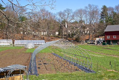
The property abutting the farm has a beautiful expanse of grass in front of it, but the only folks who can luxuriate in it are residents and guests of the high-priced townhouses hidden behind the club house.

Prior to being sold for townhouses, the estate was owned by the Lacy family, whose patriarch was an executive with the Filene's retail chain, according to this extensive blog post about the Angino family, which sold their farm to the City of Newton to create the community farm.

On the opposite side of Nahanton Street from the community farm sits an expanse of woods that once also belonged to the Shaw estate mentioned above. While part of that land was turned into the Mount Ida College campus, and another section into an office park, yet another piece became the Nahanton Woods condo development. You know me: I don't care about that. I care about the woods sitting in between the road and that development. I walked along the road, confident I'd find something worth my time. And I did.

Hard to tell from this photo but this is a small cellar hole. I have no clue how old this foundation is, or what was here. I'm guessing it was a small outbuilding for a farm on the Shaw property, perhaps even part of a stand where fruits and vegetables were sold, seeing as it's so close to the street.

As I said, Oak Hill was farming country up until the middle part of last century. In addition to farms owned by often well-to-do families, there was the poor farm run by the City of Newton. Built in 1900, the farm was the third such facility in the city (the first one was in Auburndale; the second in Waban). For more on the farm, see this article and this blog post.

The farm closed in 1964 and was torn down in 1976. The only extant building on the property is a tool house built in the late 1930's.

(Former tool house at the site of Newton's former poor farm.)

There are ruins on the site, however.

On the grounds of the former farm sit a soccer field, hiking trails and community garden plots.

(The community farmers use a variety of whimsical and practical ways to define their spaces and store their supplies.)

Adjacent to the old farm site is the Leventhal-Sidman Jewish Community Center, the grounds of which include the former Working Boys Home building.

(The former Working Boys Home is now the Jewish Community Center.)

Built in 1896, the home was an orphanage run by the Xaverian Brothers, according to Wikipedia. The home fell out of use in the 1970's.

I'm not sure what was on the site of the JCC prior to the Working Boys Home, but I stumbled across what appears to be an old stone wall, which I'm guessing was a property marker for another farm.

Just a short drive from the farm/JCC area sits a building that was once home to the Peabody Home for Crippled Children (read this article to learn more about the home). Built in 1886 as a private summer home for Harvard surgeon James Bigelow, the site served as the Peabody Home from 1895-1961. In the early '80s, WGBH's "This Old House" converted the building to condos.

I'd love to get a picture of the former estate, but without permission, the best I could get was the driveway into the property. Just up the street is the Oak Hill Pathway I mentioned at the top of this post.

(Driveway to condos in the former Peabody Home for Crippled Children.)

On the extreme eastern end of Oak Hill, bordering Boston's West Roxbury neighborhood and the city of Brookline, sit two conservation areas, one of which is unfortunately being developed as I write this. The larger one, Saw Mill Brook Conservation Area, is a nice spot with puddingstone piles and walls, and a burbling brook. As you can guess by the name, at some point there was a sawmill here, although I haven't found out much about it.

(Puddingstone wall remnants in Sawmill Conservation Area.)
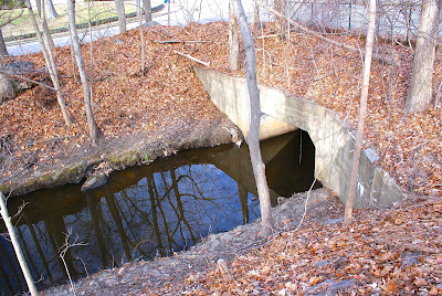
(The brook at Saw Mill Brook Conservation Area.)

Across a small side street sits Kesseler Woods, an area that was once considered for development as an energy facility by NSTAR, the successor of Boston Edison and predecessor of electric and gas company Eversource. The land was sold to a developer several years ago, with the City of Newton purchasing a smaller part to maintain as a conservation area. A small development went in a few years back, and a much larger one is currently under way.

The photo above shows the southern tip of the Kesseler property, just across Vine Street from the Saw Mill area. I'm not a geologist, so I don't know what to tell you about these stones other than that they surely used to be part of a structure, whether a house, mill building or wall.

Wrapping up my tour of Oak Hill (although this site might actually be in Newton Highlands) is a little conservation area called Oakdale Woods. I passed this spot quite a bit last year while driving my son, Owen, to school, and figured there wouldn't be much there. But I was wrong.

Acquired by the city in 1979, this small (2.5 acres) refuge sits hard by the very busy Route 9 but, according to the Newton Conservators web site, has served for years as a spot "for winter sledding, acorn fights, and informal camping."

(I love paths like this leading from neighborhoods into small suburban oases.)

(Oakdale Woods is squeezed into the neighborhood. According to the Newton Conservators web site, the spot was at one point slated for development, but the steep cliff, large boulders and outcroppings of Roxbury Puddingstone made it untenable.)

The conservators take good care of this quaint park. There is a neat path and small steps made of bricks. Someone has built a lean-to, and there is evidence of a more permanent structure.

(Remnants of a chimney, perhaps?)

As with the village of Waban (see link below), I found Oak Hill to be initially underwhelming. I didn't think I'd find much of interest to myself or Backside readers. But I followed my mantra -- Get out of the car and walk around! -- and discovered some cool features.

Here are links to the previous posts in this series:

Part IV: Waban.

Part III, Newton Highlands.

Part II, Auburndale.

Part I, Newton Lower Falls.

Next up for the series: Chestnut Hill (I think).

A Saturday Skulk Through Southie

From Dave Brigham: I've covered South Boston quite a bit on this blog (see the bottom of this post for links) yet somehow I found more...