From Dave Brigham:
I get a bit frustrated from time to time as I put together this series. Sometimes I realize after the fact that I've mistakenly placed a building or park in the wrong Newton village (the former Working Boys Home, currently the Jewish Community Center, and which is featured below, could be in Oak Hill, Newton Highlands or Newton Upper Falls, depending on which history you read, and how you interpret various maps). There are no hard and fast boundaries in the city; I do my best.
Other times I become a little bummed when I realize I'm too late (usually waaaaaay too late) to get pictures of something before it's torn down, or that I can't gain good access to snap pictures without trespassing on private property, such as was the case in Oak Hill with the former New England Peabody Home for Crippled Children. Situated on the former estate of a surgeon associated with Harvard University, the Home was converted by "This Old House" into condos in 1979. You can read more about this site and see photos, below.
Once in a while, though, I get pissed, as I did about a mostly insignificant path in Newton's Oak Hill village, the subject of today's post.
After roving back and forth across this quietest of Newton's villages, I did a bit more research and learned of something I'd overlooked called the Oak Hill Pathway. I knew exactly where the short trail was located, so I struck out to hike it and take some photos.
I was, however, thwarted in my attempt. Unlike other small conservation areas in the city, this one has been allowed to grow over, thereby restricting access. The public path crosses private land on its way from a dead-end street to the top of Oak Hill, so I wasn't surprised, just angry. From the top of the hill, according to the Newton Conservators web site, you can see the Charles River and Blue Hill, which is located several miles away in Milton, Mass.
I emailed Beth Wilkinson, the president of the Newton Conservators, to ask about the pathway. In her response, she CC'd Jennifer Steel, the city's senior environmental planner, who replied that while Newton granted a public access easement, "the deed doesn’t mention obligations of maintenance or enforcement." In other words, citizens have a right to walk on the path, but the private property owners aren't required to make it accessible.
All is not lost, however. Steel said she encourages the Conservators or other parties to "take on the task of surveying, staking, creating … and maintaining … a path." Wilkinson said she hopes that perhaps a Boy Scout troop or civic-minded high school students might take on the project.

(The Oak Hill Pathway is currently blocked. Interested visitors might want to bring a machete to make passage easier.)

(The sign for the pathway, teasing potential hikers.)
Still, there's plenty of backside to be found, and explored, in Oak Hill.
The southernmost village of Newton, Oak Hill has only the sparest of a town center and no industry or rail access. The area does contain one of the nicest walking trails the city has to offer; the city's last working farm; a mansion turned home for sick children, turned high-end condos; and a post-World War II housing development unlike anything else in Newton, among many other features.
Welcome to the fifth installment in my ongoing series about the villages of my adopted hometown of Newton, Massachusetts. For a list of the previous installments, see the bottom of this post.
A largely rural community until the 1940's, Oak Hill was home to several large farms and estates, including ones owned by families such as the Stones, Hydes, Wales, Appletons, Shaws, Wades and Bigelows. These properties have been turned into condos, golf courses (the Charles River Country Club opened in 1921 on the former Wade property, but the original house burned down), college property (Mount Ida College) and conservation areas in the past century.
Let's start with the fantastic Helen Heyn Riverway. Named for a founding member of the Newton Conservators, the riverway was constructed, according to the Conservators web site, through a partnership between the Conservators, the Newton Parks and Recreation Department, the State of Massachusetts Department of Conservation and Recreation, the Newton Conservation Commission and something called the Newton Knights of Tunsion.
(I had to find out who in the world the Newton Knights of Tunsion are. Here again, Newton Conservators President Beth Wilkinson was happy to help. She had no idea this shadowy group was referenced on her group's web site, so she did some digging. From one of the guys who helped clear the riverway path, she learned that the group's name is the Newton Knights of Tumsion (with an "m"), a "group of characters, who prefer to remain anonymous." So it's a made-up name for some good-hearted folks who helped do the dirty work of making the path passable.)
The path and adjoining woods and wetlands encompass 30 acres between the Charles River and, at various points, an office park, a private Jewish day school, Mount Ida College and residential neighborhoods. I discovered the path, as I often do, by searching on Google Maps. I started my hike from the southwestern tip of Oak Hill Park, a planned community that I'll get to a little further down. There were a few whimsical, man-made touches as I walked along: a rope swing hanging from a tree, some broken-down chairs. Frolicking by students from the nearby college, I assumed.
The path led me through a boggy section toward the banks of the Charles. And there I took a picture that has become one of my favorites of all time.

It was so peaceful down here, especially in the winter, I can see why someone brought a chair down to contemplate life.
The path connects to both Millennium Park and the historic Brook Farm in Boston's West Roxbury neighborhood. Across the Charles is Cutler Park, which I've written about before (see November 20, 2011, "History Flows On, Part II," and December 6, 2011, "History Flows On, Part III").
The riverway sits on land once owned by Robert Gould Shaw II, a Mayflower descendant whose cousin of the same name (minus the "II") is famous for leading the first all-black regiment recruited in the North during the Civil War, as seen in the movie "Glory." RGS II, as he was sometimes called, was a wealthy landowner and socialite (read: idle rich layabout) who died in 1930 at the age of 58, according to Wikipedia. By that time the family fortune -- amassed thanks to mining investments -- had vaporized. The family sold the "vacant and decaying estate" in 1939, and part of the property became the new campus for Mount Ida College, according to Wikipedia (Oh, how I would have LOVED to explore that estate in the '30s!). Another part of the estate was sold off for the Wells Avenue office park.

(Stone walls along the Helen Heyn Riverway.)

(A bridge leading from the riverway across a small brook and into the Wells Avenue office park. The path goes through the park a short distance before curving back toward the river. There has long been a plan to build a crossing over a marsh, thereby eliminating the need to walk through the park.)

(Getting closer to the Newton/Boston border, I came across this tree.)

(On the outskirts of the Oak Hill Park development, just off the riverway, sits an antenna for WUNR, "one of Greater Boston's oldest ethnic radio stations," according to its web site.)
Oak Hill Park was developed in 1948 after the City of Newton took the land by eminent domain (formerly the Estes and Wiswall farms and a deserted gravel pit, according to the Internet) with the goal of building a planned community for veterans returning from World War II. The city built more than 300 homes and, eventually, a school and small shopping center (the school is now a private Jewish school; the shopping center is fairly quiet). Several paths run between streets and behind houses, giving the neighborhood a special sense of connection. There is nothing like this in the rest of the city.

(One of several paths in Oak Hill Park; the paths are named for Newton servicemen lost in the war.)

(The former Oak Hill branch library, now the Shuman Center, which serves as home for the neighborhood association.)
As you would expect in a planned community built in the late 1940's, the homes of Oak Hill Park are modest. Well, most of them. In recent years, as in every village of Newton, Oak Hill has fallen victim to The Teardown (see March 18, 2011, "Anatomy of a Teardown," and May 9, 2016, "Shedding Tears (Sometimes) for Teardowns," which features photos that your are about to see below.)
Here's a house that hasn't changed since it was built nearly 70 years ago.

And here's a house that has either been heavily modified or possibly replaced a smaller one that was torn down.

This one is much larger than abutting homes but isn't monstrous; there are more egregious examples sprinkled throughout Oak Hill Park. This type of mega-house development doesn't sit too well with many in the area.
Still, there is more open space in Oak Hill than in any other Newton village, although not all of it is accessible to the public, as I ranted about above.
The last working farm in the city, Newton Community Farm operates a Community Supported Agriculture (CSA) program, donates produce to various food pantries, offers classes and volunteer opportunities and hosts dinner events. The site has been farmed for 340 years by settlers, according to the farm's web site.

The property abutting the farm has a beautiful expanse of grass in front of it, but the only folks who can luxuriate in it are residents and guests of the high-priced townhouses hidden behind the club house.

Prior to being sold for townhouses, the estate was owned by the Lacy family, whose patriarch was an executive with the Filene's retail chain, according to this extensive blog post about the Angino family, which sold their farm to the City of Newton to create the community farm.
On the opposite side of Nahanton Street from the community farm sits an expanse of woods that once also belonged to the Shaw estate mentioned above. While part of that land was turned into the Mount Ida College campus, and another section into an office park, yet another piece became the Nahanton Woods condo development. You know me: I don't care about that. I care about the woods sitting in between the road and that development. I walked along the road, confident I'd find something worth my time. And I did.

Hard to tell from this photo but this is a small cellar hole. I have no clue how old this foundation is, or what was here. I'm guessing it was a small outbuilding for a farm on the Shaw property, perhaps even part of a stand where fruits and vegetables were sold, seeing as it's so close to the street.
As I said, Oak Hill was farming country up until the middle part of last century. In addition to farms owned by often well-to-do families, there was the poor farm run by the City of Newton. Built in 1900, the farm was the third such facility in the city (the first one was in Auburndale; the second in Waban). For more on the farm, see this article and this blog post.
The farm closed in 1964 and was torn down in 1976. The only extant building on the property is a tool house built in the late 1930's.

(Former tool house at the site of Newton's former poor farm.)
There are ruins on the site, however.


On the grounds of the former farm sit a soccer field, hiking trails and community garden plots.

(The community farmers use a variety of whimsical and practical ways to define their spaces and store their supplies.)
Adjacent to the old farm site is the Leventhal-Sidman Jewish Community Center, the grounds of which include the former Working Boys Home building.

(The former Working Boys Home is now the Jewish Community Center.)
Built in 1896, the home was an orphanage run by the Xaverian Brothers, according to Wikipedia. The home fell out of use in the 1970's.
I'm not sure what was on the site of the JCC prior to the Working Boys Home, but I stumbled across what appears to be an old stone wall, which I'm guessing was a property marker for another farm.
Just a short drive from the farm/JCC area sits a building that was once home to the Peabody Home for Crippled Children (read this article to learn more about the home). Built in 1886 as a private summer home for Harvard surgeon James Bigelow, the site served as the Peabody Home from 1895-1961. In the early '80s, WGBH's "This Old House" converted the building to condos.
I'd love to get a picture of the former estate, but without permission, the best I could get was the driveway into the property. Just up the street is the Oak Hill Pathway I mentioned at the top of this post.

(Driveway to condos in the former Peabody Home for Crippled Children.)
On the extreme eastern end of Oak Hill, bordering Boston's West Roxbury neighborhood and the city of Brookline, sit two conservation areas, one of which is unfortunately being developed as I write this. The larger one, Saw Mill Brook Conservation Area, is a nice spot with puddingstone piles and walls, and a burbling brook. As you can guess by the name, at some point there was a sawmill here, although I haven't found out much about it.

(Puddingstone wall remnants in Sawmill Conservation Area.)

(The brook at Saw Mill Brook Conservation Area.)
Across a small side street sits Kesseler Woods, an area that was once considered for development as an energy facility by NSTAR, the successor of Boston Edison and predecessor of electric and gas company Eversource. The land was sold to a developer several years ago, with the City of Newton purchasing a smaller part to maintain as a conservation area. A small development went in a few years back, and a much larger one is currently under way.

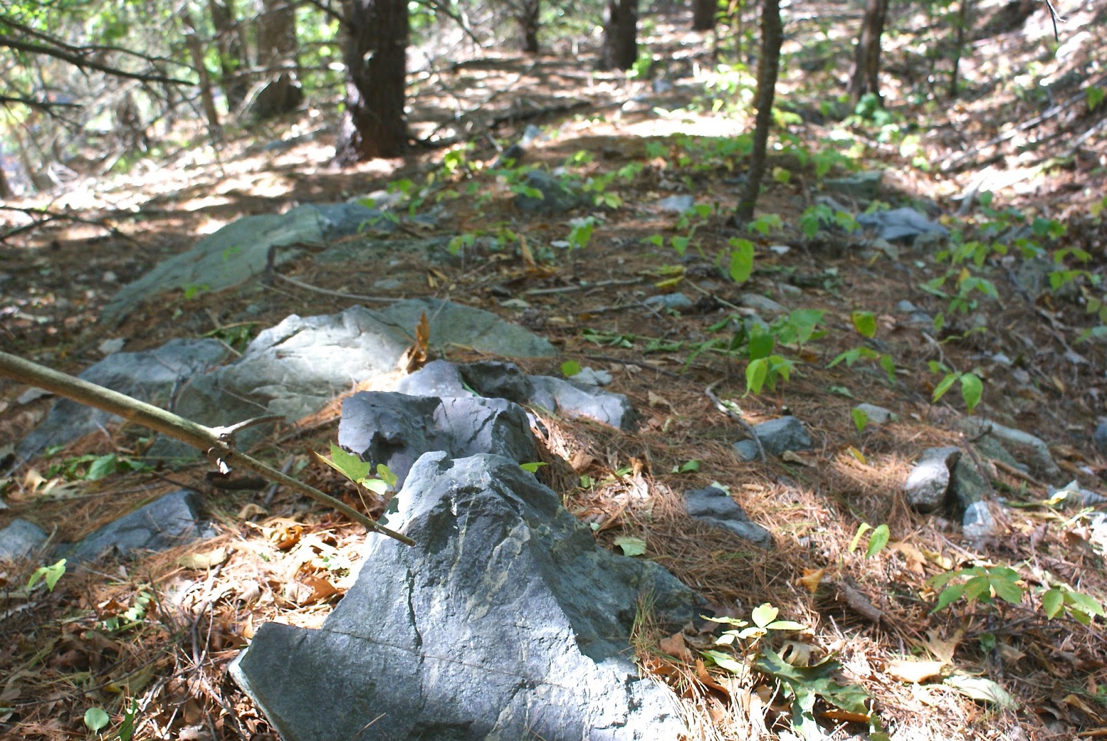
The photo above shows the southern tip of the Kesseler property, just across Vine Street from the Saw Mill area. I'm not a geologist, so I don't know what to tell you about these stones other than that they surely used to be part of a structure, whether a house, mill building or wall.
Wrapping up my tour of Oak Hill (although this site might actually be in Newton Highlands) is a little conservation area called Oakdale Woods. I passed this spot quite a bit last year while driving my son, Owen, to school, and figured there wouldn't be much there. But I was wrong.
Acquired by the city in 1979, this small (2.5 acres) refuge sits hard by the very busy Route 9 but, according to the Newton Conservators web site, has served for years as a spot "for winter sledding, acorn fights, and informal camping."

(I love paths like this leading from neighborhoods into small suburban oases.)

(Oakdale Woods is squeezed into the neighborhood. According to the Newton Conservators web site, the spot was at one point slated for development, but the steep cliff, large boulders and outcroppings of Roxbury Puddingstone made it untenable.)
The conservators take good care of this quaint park. There is a neat path and small steps made of bricks. Someone has built a lean-to, and there is evidence of a more permanent structure.

(Remnants of a chimney, perhaps?)
As with the village of Waban (see link below), I found Oak Hill to be initially underwhelming. I didn't think I'd find much of interest to myself or Backside readers. But I followed my mantra -- Get out of the car and walk around! -- and discovered some cool features.
Here are links to the previous posts in this series:
Next up for the series: Chestnut Hill (I think).


