Saturday, April 30, 2022

Mr. Paranoid Visits an Old Mill

From Mr. Paranoid:

Be careful.

While I get excited by sights like these, I have to remind myself to keep my head on a swivel, my eyes peeled, my ears on alert and my spidey senses a-tingling. Drug deals? Booze bashes? Gang rituals? Homeless encampment? Who knows what goes on in a place like this, even in the middle of the day.

Don't get me wrong: I'm not saying abandoned mills are filled with bad people doing bad things. Not all the time, anyway. I just don't want to get caught up in any of that funky shit goin' down in the city. I've got kids and a wife, and I don't want to be dragging my 57-year-old legs away from trouble with a camera lashed around my neck, my mother wondering, "Where is Dave? He was supposed to be here an hour ago."

Of course, I was also thinking, "How often do the cops check in on this place?" Sure, I'm a chicken. I don't do urbex that much, and when I do, I like to get in and out pretty quickly.

So, let's get to more photos and facts about this old mill complex in Manchester, Connecticut.

Ahead of a recent visit with my Mom, I decided to cruise through the Silk City. I'd stumbled across a reference online to a long-abandoned mill, so that was my first stop. I also checked out the city's main drag, which I will feature in a future post.

Manchester is an old mill town, which is why I wanted to visit. I grew up 30 minutes from here, but knew very little about the City of Village Charm, as its motto says. I knew there were a lot of intact mill buildings in the Cheney Brothers Historic District, but I stayed away...for now. "The 175-acre district includes over 275 mill buildings, workers houses, churches, schools and Cheney family mansions," according to Wikipedia. "These structures represent the well-preserved company town of the Cheney Brothers silk manufacturing company, the first America-based silk company to properly raise and process silkworms, and to develop the difficult techniques of spinning and weaving silk." At one time, this operation represented the world's largest silk mill.

But you know me, I'm not that interested in "well-preserved" places. I'll likely check out that district in a future visit, as I'm sure there are plenty of cool things to make photos of. Instead, I sought out the derelict mill just north of Union Pond, in the town's northern section, not far off Interstate 84.

I accessed these ruins quite easily, walking up a driveway off a very busy Route 30. I expected to see "No Trepassing" signs, but there were none. Neither did there appear to be security cameras or any other deterrent keeping urban explorers, taggers and party-seekers out. So what is this place?

I believe the smokestack is the only remnant of the former Oakland Paper mill. A predecessor mill on this property at one time produced paper for the Connecticut Courant (which became the Hartford Courant), according to this Journal Inquirer article. This site is just north of Union Pond; there was also a cotton mill at the southern end of the pond, where the Hockanum River is dammed.

Mills were first established on this site in 1784 by a company called Butler and Hudson, according to this Manchester Historical Society article. The mills "operated under various owners and through various reorganizations, manufacturing high-quality papers, including bank-note paper and all the post-card paper for the U.S. government," the article continues. "In 1899, the American Writing Paper Company, an early conglomerate, bought the Oakland Mill, and replaced former wooden buildings with brick. Like many businesses, the paper mills suffered financially during the Depression, and went out of business in 1933. Dexter Company bought the mills and processed pulp there for a while. Other businesses have used the buildings since then, including Raybestos, Conyers (cement casting), and a recycling center."

I don't know when the brick buildings were torn down. The buildings that remain are newer and sheathed in corrugated metal. I can see where the recycling center was. I didn't check out the entire site to see if there are other brick remnants other than the smokestack.

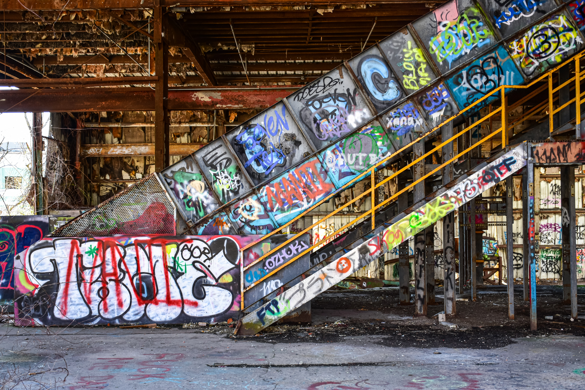
As with just about any site like this, especially ones that are freely accessible and right off the beaten path, there is graffiti galore.

So what's to become of this beaten-down, tagged-up, well-polluted site?

The 7.3-acre lot is on the market for $850,000. I imagine the cost to clean up the site is significantly higher than the price for the property. What would somebody build here? I'm guessing self-storage.

Saturday, April 23, 2022

A Wonderful Walk in Wellesley Hills

From Dave Brigham:

While I've written a few posts about Wellesley (see May 18, 2012, "Aqueduct, My Friend" and January 20, 2018, "The Fabulous Baker Estate," which is more about Needham than Wellesley), this well-to-do town in Boston's western suburbs isn't the first town I think of when pondering on the backside of America. That's a bias I recently set about changing.

I started with a tour of Wellesley Hills, the neighborhood bounded by the Route 9/Washington Street intersection to the east, Wellesley Square to the west, Babson Park to the south and Wellesley Farms to the north. The commuter rail runs parallel to Washington Street here, and there are many commercial buildings, churches, apartment buildings, stores and older homes.

I started at Elm Park, a triangular slice of heaven tucked between Washington Street and Route 9. The park's prominent feature is the gorgeous Isaac Sprague Clocktower.

The brick-and-masonry tower rises 75 feet and features a clock and bell given to the town in 1874 by John Shaw, who worked in Wellesley's school system for many years. The tower itself wasn't erected until 1928. It is named for Isaac Sprague, who "sat on the committee which oversaw its construction, and donated materials for that purpose," according to Wikipedia.

There is also a very cool antique water fountain in the park.

The fountain was made by Murdock Manufacturing out of Cincinnati. I'm not sure how old the fountain is, or whether it works.

If you visit, look for the stone labyrinth at the southeast corner of the park, near the Unitarian Universalist Church.

Speaking of that church....

Built in 1888, the church has some wonderful architectural quirks, from the eyebrow window over the front door and the unusual spire, to the rounded, turret-like entrance near the rear of the building. The church was built for a congregation that formed in 1871 in what was then known as the Grantville neighborhood of Needham. Wellesley broke off from Needham in 1881. The grounds of the church also include an auditorium and a parish house.

Continuing southwest on the north side of Washington Street, I had to check out the bridge that carries Cliff Road over the commuter train tracks.

I don't check out bridges that often, but when I find one with such a great patina, I go out of my way. And I'm glad I did, as I spied a couple of nice relics.

Boston Bridge Works, Inc. was in business in the late 19th and early 20th centuries, as best as I can tell. The company had a factory somewhere in East Cambridge. To see a bunch of cool bridges built by the company, check out this Flick album.

(A nice plaque on the bridge featuring the Massachusetts State Seal, upon which I will not comment.)

I wasn't going to shoot a photo of the building below, but when I saw the sign indicating "PLAYHOUSE SQUARE" I figured this building had history to it.

Currently home to a law office and I'm not sure what else (the bakery went out of business in 2020), this building along Washington Street is known historically as the Wellesley Community Playhouse, and also the Babson College Clubhouse. It was built in 1921 by Babson for conferences, movies and theater productions, per MACRIS. From 1923 to 1986 the building was operated privately as a movie theater with 499 seats.

"The theatre closed because it losts (sic) its lease, not because it was unsuccessful (to the contrary, it did great business with second-run art stuff and kids' matinees [which I attended regularly] in the '80s)," according to a commenter on the Cinema Tour web site. The marquee was removed in 2008, according to a commenter on the Cinema Treasures web site.

The furthest west I went on Washington Street was to a neat old bus shelter in front of the town's police department.

Approved by the town's zoming board of appeals in October 1978 in order to provide residents of an adjacent housing authority complex with easier access to bus service, the shelter dates from the late '70s or early '80s. I've never come across a public transportation building quite like this one.

UPDATE: As of late June 2022, this bus shelter has been torn down.

Heading back east along Washington Street, I spied something in a parking lot behind the UPS Store that I decided to check out.

The Local is part of a three-restaurant chain (it was four until recently, when the Newton location closed). The Wellesley spot is situated in what I believe is a former trucking company building. MACRIS indicates a circa-1838 Greek Revival house was moved to this site in 1916 (and demolished at an unknown date after 1981). William and Mabel Diehl operated a moving company out of the house, which included a large barn at the rear of the property where they parked their vans and trucks, according to MACRIS. The barn burned down at some point. Albert and Laura DeBello operated the Wellesley Trucking Company here in the 1970s. I'm assuming the brick building housing The Local replaced the burned-down barn and was used to house the trucks.

Just steps away from the restaurant I found an entry point to the Crosstown Trail on Forest Street.

The trail starts at Wellesley's border with Natick, where the Cochituate Aqueduct Trail enters town. It winds through residential neighborhoods, borders Morses Pond, runs behind town hall, skirts the high school athletic complex, parallels Washington Street and eventually meets up with the Charles River Path.

I love paths like this that allow people to cut behind the main streets and through neighborhoods, getting views that we don't get when driving. Paths like this often upset residents (not just in Wellesley), because they bring the hoi polloi into close contact with locals.

OK, that's it for Wellesley Hills. I hope to check out other parts of town in the near future.

Saturday, April 16, 2022

Jamming Through Allston, Part IV: Artsy Stuff

From Dave Brigham:

I never tire of stumbling across murals and kick-ass graffiti when I'm out and about with my camera. As I've discovered over the years, some murals last a really long time, while others are ephemeral, getting defaced or painted over or bulldozed. To finish up my series about Boston's Allston neighborhood, I want to showcase a TON of public art, and talk about which of these works will soon fall under the wrecking ball (very few, thankfully), which ones should survive for a while, and give credit to the artists where possible.

For links to the previous three installments in this series, see the bottom of this post.

I'm going to start with the most stunning mural in Rock City.

Located on a side wall of a CVS store, at the end of dead-end Harvard Terrace, this masterpiece was painted by Gregg Bernstein, whose work fills this neighborhood. This mural shows the Boston Public Garden in vivid colors that are probably not far from the reality of a high-autumn day in the city. It's such a shame that this work is tucked down a side street that few people travel down. This one dates to 2016.

Let's check out more of Bernstein's work.

The building-sized postcard above can be seen on the side of Azama Grill at the corner of Farrington and Harvard avenues. Bernstein painted this in 2012.

Located on the corner of Commonwealth and Harvard avenues, overlooking the trolley tracks, this tribute to Allston, Boston and the MBTA also dates to 2016. I wish it were easier to see (and photograph) from street level.

Painted on the side of Fast Eddie's Smoke Shop, this mural shows Harvard Avenue in modern times (on the right) and olden times (on the left, which I did a terrible job of capturing).

Finally, we have this one on dead-end Glenview Terrace, on the side of Blue Moon Smoke Shop, which is directly across Harvard Avenue from Fast Eddie's.

My second favorite Allston mural is also on Glenview Terrace.

I'm not sure whether Bernstein also painted this one, which is located on the side of Glenville Terrace Auto Body & Repair. He doesn't feature it on his web site.

While my two favorite Allston murals are tucked away a bit, the beauty on the side of The Silhouette Lounge is easy to spot.

Known as "The Famous Joe's," this one was painted by the Boston Mayor's Mural Crew and Johanna Kenney. Can you name all the Joes?

This lovely splash of color on the side of Scissor Sound Hair Studio was painted by Ryan Adams (no, that this Ryan Adams).

On the side of the Gordon Building along Glenville Avenue is this one painted by the Mayor's Mural Crew.

In an alley/driveway between Allston Car Wash and Bazaar on Cambridge there is a lovely, eye-popping series of food- and flower-related paintings.

At least some, if not all, of the works are by Lena McCarthy, who painted a mural that I featured in a post about Framingham last October.

I assume McCarthy painted the front of Bazaar as well.

The mural on Allston & Brighton APAC Child & Family Service Center, below, is really nice. I couldn't find any information online about who painted it.

Across Cambridge Avenue from the APAC site is a nice mural on the side of Sheesha Lounge, a hookah bar that may or may not still be open.

I'm not sure who painted this one.

Around the corner, on Denby Street, is this mural with brightly colored leaves and two cuddly creatures.

This one was painted by Caleb Neelon, who has completed murals in Brazil, Nepal, Honduras and other countries, as well as many in and around Boston. I featured one of his murals in a post about Cambridge's Central Square.

I can't decide if the mural below would look better with the trash bins moved out of the way.

I like the concept of a big bang exploding out of the refuse of urban life and the two figures soaking it up. I don't know who painted this.

Next, I want to highlight a few electrical box works.

Located on Cambridge Street in front of Allston Collision Center, this funked-up cassette tape and bees mural was done by Nicole Barr.

The one below, located on North Beacon Street in front of vegan restaurant Grasshopper, was painted by Merlo Philiossaint, who has painted other electrical boxes, in addition to plenty of other stuff.

Let's check out some free-form stuff.

Located down an alley heading toward Allston Auto Works, this work is painted on a brick wall, but it looks like it could have been removed from the wall of a local museum or gallery. I don't know who the artist is.

The graffiti below is located on the side of Action Bearing Company, which manufactures ball bearings, cam followers, spherical bushings and other stuff that I know nothing about.

In a back alley behind the Azama Grill, I spied the graffiti below, which I like, although I'm not sure exactly why. I guess I dig the blue door and red awning. Would I like them more without the graffiti? Perhaps.

The next piece has been in place for quite some time, I think. I heart it.

Located on a pedestrian bridge that spans the Mass. Pike, connecting Cambridge and Lincoln streets, this work is an entreaty for love. "Nasr, my dear," it reads. "What if we were to meet in Sumra, in the Garden of Eden, free from bliss, in a state of complete innocence. Mary."

Sumra is located in Iran.

All of the works above are safe for the foreseeable future, as far as I know. The ones below, however, are not.

The Parma Chai Out of the Blue Community Arts Gallery has a space inside the former fire station on Harvard Avenue. In the alley between that building and 2 Harvard Avenue, the gallery exhibits some works. The latter building is slated to be demolished as part of the Allston Square development that has been approved by the Boston Planning & Development Agency.

While Allston Square's developers have pledged to "host a lot of public artwork, including murals and sculptures as well as 9,000 square feet of exhibition space amid 27,758 square feet of open space," according to documents available online, the public will nonetheless be robbed of some existing art.

A former service station on Cambridge Street has become an outdoor graffiti gallery.

I won't mourn the loss of those tagging works. But I am saddened by the future destruction of the works of art in the photos below.

"There's a new world rising from the shambles of the old," this work says, perhaps ironically. I'm not sure how long this beautiful mural has been here. Did the artist know this building would be torn down?

The masterpiece below should be removed carefully and installed in a location where the public can enjoy it in perpetuity.

I've been unable to find out who painted this. I don't think it's an officially sanctioned work. I hope that the artist is being paid to create art like this somewhere.

Well, that wraps up my Allston series. Below are links to the previous three parts.

April 9, 2022, "Jamming Through Allston, Part III: Buildings and Other Old Stuff"

April 2, 2022, "Jamming Through Allston, Part II: The Future"

March, 26, 2022, "Jamming Through Allston, Part I: Rock City"

More Military Relics in the Home of the American Revolution

From Dave Brigham: My hour-long hike through the Annursnac-Baptist Brook Conservation Area would have been perfect, but for the distant wh...