From Dave Brigham:
While I've written a few posts about Wellesley (see May 18, 2012, "Aqueduct, My Friend" and January 20, 2018, "The Fabulous Baker Estate," which is more about Needham than Wellesley), this well-to-do town in Boston's western suburbs isn't the first town I think of when pondering on the backside of America. That's a bias I recently set about changing.
I started with a tour of Wellesley Hills, the neighborhood bounded by the Route 9/Washington Street intersection to the east, Wellesley Square to the west, Babson Park to the south and Wellesley Farms to the north. The commuter rail runs parallel to Washington Street here, and there are many commercial buildings, churches, apartment buildings, stores and older homes.
I started at Elm Park, a triangular slice of heaven tucked between Washington Street and Route 9. The park's prominent feature is the gorgeous Isaac Sprague Clocktower.

The brick-and-masonry tower rises 75 feet and features a clock and bell given to the town in 1874 by John Shaw, who worked in Wellesley's school system for many years. The tower itself wasn't erected until 1928. It is named for Isaac Sprague, who "sat on the committee which oversaw its construction, and donated materials for that purpose," according to Wikipedia.


There is also a very cool antique water fountain in the park.


The fountain was made by Murdock Manufacturing out of Cincinnati. I'm not sure how old the fountain is, or whether it works.
If you visit, look for the stone labyrinth at the southeast corner of the park, near the Unitarian Universalist Church.
Speaking of that church....
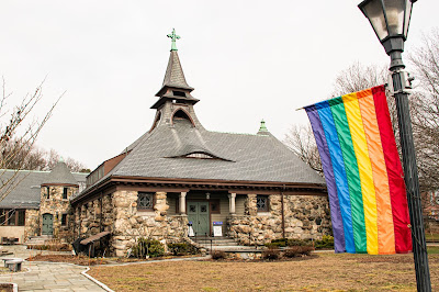
Built in 1888, the church has some wonderful architectural quirks, from the eyebrow window over the front door and the unusual spire, to the rounded, turret-like entrance near the rear of the building. The church was built for a congregation that formed in 1871 in what was then known as the Grantville neighborhood of Needham. Wellesley broke off from Needham in 1881. The grounds of the church also include an auditorium and a parish house.
Continuing southwest on the north side of Washington Street, I had to check out the bridge that carries Cliff Road over the commuter train tracks.

I don't check out bridges that often, but when I find one with such a great patina, I go out of my way. And I'm glad I did, as I spied a couple of nice relics.

Boston Bridge Works, Inc. was in business in the late 19th and early 20th centuries, as best as I can tell. The company had a factory somewhere in East Cambridge. To see a bunch of cool bridges built by the company, check out this Flick album.

(A nice plaque on the bridge featuring the Massachusetts State Seal, upon which I will not comment.)
I wasn't going to shoot a photo of the building below, but when I saw the sign indicating "PLAYHOUSE SQUARE" I figured this building had history to it.

Currently home to a law office and I'm not sure what else (the bakery went out of business in 2020), this building along Washington Street is known historically as the Wellesley Community Playhouse, and also the Babson College Clubhouse. It was built in 1921 by Babson for conferences, movies and theater productions, per MACRIS. From 1923 to 1986 the building was operated privately as a movie theater with 499 seats.
"The theatre closed because it losts (sic) its lease, not because it was unsuccessful (to the contrary, it did great business with second-run art stuff and kids' matinees [which I attended regularly] in the '80s)," according to a commenter on the Cinema Tour web site. The marquee was removed in 2008, according to a commenter on the Cinema Treasures web site.
The furthest west I went on Washington Street was to a neat old bus shelter in front of the town's police department.


Approved by the town's zoming board of appeals in October 1978 in order to provide residents of an adjacent housing authority complex with easier access to bus service, the shelter dates from the late '70s or early '80s. I've never come across a public transportation building quite like this one.
UPDATE: As of late June 2022, this bus shelter has been torn down.

Heading back east along Washington Street, I spied something in a parking lot behind the UPS Store that I decided to check out.

The Local is part of a three-restaurant chain (it was four until recently, when the Newton location closed). The Wellesley spot is situated in what I believe is a former trucking company building. MACRIS indicates a circa-1838 Greek Revival house was moved to this site in 1916 (and demolished at an unknown date after 1981). William and Mabel Diehl operated a moving company out of the house, which included a large barn at the rear of the property where they parked their vans and trucks, according to MACRIS. The barn burned down at some point. Albert and Laura DeBello operated the Wellesley Trucking Company here in the 1970s. I'm assuming the brick building housing The Local replaced the burned-down barn and was used to house the trucks.
Just steps away from the restaurant I found an entry point to the Crosstown Trail on Forest Street.

The trail starts at Wellesley's border with Natick, where the Cochituate Aqueduct Trail enters town. It winds through residential neighborhoods, borders Morses Pond, runs behind town hall, skirts the high school athletic complex, parallels Washington Street and eventually meets up with the Charles River Path.
I love paths like this that allow people to cut behind the main streets and through neighborhoods, getting views that we don't get when driving. Paths like this often upset residents (not just in Wellesley), because they bring the hoi polloi into close contact with locals.
OK, that's it for Wellesley Hills. I hope to check out other parts of town in the near future.


No comments:
Post a Comment