Wednesday, April 27, 2016

Train Wreck???

From Mick Melvin:

I was driving in New Britain, CT, one day and I did a double take.

Untitled

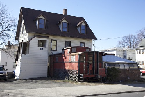
I couldn’t believe my eyes when I saw a train sticking out of a house. It was actually a big red caboose, which is in fact, attached to the house. Well, it's actually attached to the house and another room is attached to the side of the train.

Some folks from New Britain told me the place was called Reno's Cafe. The records show it was established in 1990 and incorporated in Connecticut. I searched reviews for the place, and the last mention of the restaurant was in 2013. The review said the place was nice and it was more of a bar than a café. They actually applied for a liquor license in 2013-2014, but I could find no other mention of the place.

Wednesday, April 20, 2016

Washington Walked Here

From Dave Brigham:

It's always better to get out and walk. Seems obvious, no? Driving is faster, sure, but you miss so much. People sometimes ask me, "How do you find all these places to write about and take pictures of?" All you gotta do, I say, is walk around a bit.

After driving through the intersection of Main Street/Rte. 20, Weston Street/Rte. 117 and South Street in Waltham, Mass., numerous times, I found myself focusing on two stone monuments on the grounds of the former Banks School. So one day when I had a few minutes, I parked in the school lot and walked up to see what these big slabs are all about.

This one commemorates the so-called Henry Knox Trail, the path that the general took in late 1775/early 1776 from Fort Ticonderoga in New York to Boston to deliver 59 cannons to Gen. George Washington. Other markers along the trail are located in New York towns and cities including Glens Falls, Hudson Falls, Schuylerville and Albany, and Massachusetts towns and cities including Palmer, Marlborough, Framingham and Cambridge.

Here's a detail from the marker.

This marker is for the George Washington Memorial Highway.

The highway -- aka Route 20 -- was created in 1932 to celebrate the bicentennial of Washington's birth, and the route that he took on his way to Boston to assume command of the Continental Army. "There were parades from Agawam to Cambridge," at the time, according to Bryan Farr, founder of The Historic U.S. Route 20 Association, quoted in the MetroWest Daily News in June 2014. "They had a guy dressed up like Washington ride a horse along the route. The streets were lined with people."

The state, however, declined to officially name Route 20 after Washington.

Here's a detail of the marker.

You never know what you'll learn when you go for a little jaunt.

Wednesday, April 13, 2016

The Ones That Got Away, Part IV

From Dave Brigham:

It's ironic that Anthony's Pier 4, the venerable waterfront restaurant in Boston that was once the place to see and be seen, is being torn down as the neighborhood around it has risen to become the hottest spot in the city.

I went to Anthony's once, to celebrate when my girlfriend (now wife), Beth, graduated from law school. I'd heard of the place from Beth's family, and knew somewhat of its reputation as a special occasion destination and place where celebrities hung out when they were in town.

We took pictures on the back deck, which overlooked Boston Harbor and had great views of the city and the airport. The food was good, not great, but I reveled in looking over the dozens of photos in the hallway leading from the front door into the restaurant: owner Anthony Athanas with Liz Taylor, Judy Garland, Merv Griffin, Johnny Carson and many other A-listers.

Athanas opened his restaurant in 1963. He died in 2005 but the restaurant lived on for eight more years. In its later years, Anthony's Pier 4 fought for customers with a crowd of high-end restaurants in downtown Boston, as well as more options along the waterfront, which was christened the Seaport District in recent years.

I wish I'd taken some photos of the place in its heyday and in more recent years as it sat waiting for its fate. I didn't, but the Boston Globe recently ran some photos from the salad days of Anthony's Pier 4 -- including one of the former passenger liner that was used as a cocktail lounge until it sunk during the blizzard of '78 -- as well as images of the place stripped, unfortunately, of its glory. You can see them here.

Demolition crews began ripping the restaurant down yesterday.

Here are three previous nods to ones that got away:

May 2, 2010, about the former Metz Automobile Factory in Waltham, Mass.

June 1, 2010, about the former Whalom Park in Leominster, Mass.

June 5, 2015, about Veronica's Spa in Waltham, Mass.

Thursday, April 7, 2016

Sweet and Junky

From Dave Brigham:

Somerville, Mass., was once the car-theft capital of America, according to Wikipedia, and, more importantly, my friend Jim who grew up there in the 1960s and '70s. The city was much grittier back then, with the Winter Hill Gang in cahoots with the infamous Whitey Bulger, and factories and small industry dominating much of the business landscape. In more recent years, the city, a tightly packed mixture of blue collar workers, hipsters, college students and professionals tucked between Cambridge, Medford, Boston and Arlington, has become a mecca for bars, restaurants, clubs and funky shops and start-up companies.

It was while checking out one of these newer companies -- Taza Chocolate -- a while back that I stumbled across a part of the old Somerville that I suspect not many of the newer residents know about.

Located in a large factory building that once housed companies including Consolidated Bag & Foil Corp. and Sugarman Brothers, according to the Somerville Historic Preservation Commission, Taza offers regular tours of its operations -- and free samples! As my kids and I drove down Windsor Street toward the factory, we passed by a junkyard, with stacks of cars and trucks on both sides of the roadway looming behind corrugated metal fences.

We enjoyed learning how the confections are made, as well as eating the free samples of dark chocolate mixed with all sorts of fruits, peppers, nuts and other ingredients. Well, I liked them anyway.

I made a mental note to visit the area again to take photos of the junkyard, and finally got around to it a few months ago.

The place -- Nissenbaum's Quality Used Auto Parts -- made an even bigger impression on me the second time. Around since 1910, the company is operated by fourth and fifth generations of the founding family, in the same location, I believe.

This gives you a sense for the history of the place, which is the favorite junkyard of the "Car Talk" guys.

And this gives you a sense of how tight things are in this neighborhood, which is very close to a set of train tracks, and which formerly hosted slaughterhouses and meat packing companies.

But this being Somerville, a community increasingly filled with eco-conscious folks, the junkyard backs up to a community garden.

Below are views of the front and back of the junkyard.

In addition to at least one other junkyard in this area, there are auto parts stores and repair shops. Here are two shots of Columbia Auto Parts.

I highly recommend checking out both the chocolate factory and the junkyard. And there are countless great bars, restaurants and shops a short distance away, as well as the Slumbrew tap room.

Wednesday, March 30, 2016

Big Walk in Littleton

From Dave Brigham:

It's hard to capture the history and feel of a town simply by spending a few hours there, snapping away while (mostly) following a pre-established route designed to hit the highlights. But that's all I can do, except in my adopted hometown of Newton, Mass. (see May 21, 2015, "I Seek Newton, Part I: Lower Falls," and September 20, 2015, "I Seek Newton, Part II: Auburndale," and March 23, 2016, "I Seek Newton, Part III: Highlands").

Littleton, Mass., was settled by colonists in 1686. A small farming community back then, and even somewhat to this day, the town nonetheless has played a part in the state's digital economy, hosting large complexes first for Digital Equipment Corp., and then IBM, according to Wikipedia.

When visiting a town I know little or nothing about, I make no pretense of covering everything, or even most things, that are historically significant. While I love the beautiful old farm houses and Victorians I see in every town in Massachusetts, I'm more interested in the industries of old -- railroads, factories, mills. I take great pleasure in the hunt for the obscure location, the forgotten place.

I've done numerous drive-by photo shoots of communities in the area near Routes 2, 495, 117, 190, 20 and 62 (see February 17, 2016, "Bunker Buster," December 29, 2015, "Gravity Can Lift You Up," December 17, 2015, "Bring Out Your Dead," December 9, 2015, "Scenes From An Old Shoe Town," November 30, 2015, "Walking Dead Tracks" and November 8, 2015, "This Town Ain't Big Enough....").

All I knew about Littleton before visiting was a) I drove through there to get to Kimball Farm in Westford, and b) a client of the accounting firm where I worked 20 years ago owned Nagog Hill Orchard. As always, I did some research online ahead of time to find a handful of sites to check out.

Here's what I found....

(The Littleton Depot, built in 1879, is home to Erickson's Antique Stoves.)

(Boston & Maine caboose, which sits next to a few rusty freight cars, behind the depot.)

(Littleton Depot guard shanty.)

(Inactive loading docks at bottling plant that was most recently for Sunny Delight. That company bought Veryfine, a successor company to a cider mill begun in 1865, according to Wikipedia. Veryfine was an integral part of Littleton until it closed last fall.)

(Covered walkway at Sunny Delight/Veryfine plant, which is just down the street from the old depot.)

(Administrative building at former Sunny Delight plant.)

The road off Route 2A that would have taken me to my next stop, a cemetery, was closed. So I drove a bit more until I hit the town of Groton. Just over the border, I saw this church.

After a bit of research, I learned that the pastor has moved to an Emmanuel Church in Ayer. Not sure what will become of this place.

The next spot on my list was the Hartwell Family Memorial Preserve. I had two goals at this conservation area: get a bit of exercise and seek out the old stone slab bridge indicated on the Littleton Conservation Trust web site.

I was planning on walking most of the way, but the snow pack on the trails was so severely iced over that I ended up slip sliding/ice skating my way much of the time. Thankfully I didn't fall or strain any muscles. I found the bridge, which isn't all that impressive, except for the fact that it's about 150 years old.

The site includes wooded areas, a brook/swamp, small meadows and a field where crops were formerly planted.

Next I headed east on Route 2A toward the busier areas of town. Next to the Masonic Hall (Tahattawan Lodge) is a scuffed up sign for the former Central Hall. Built in the early 1800's, the hall hosted town meetings and dances, as well as grange and church meetings. The building also served as the town's post office and telephone office, as well a gas station, bakery and grocery store over the years. It was abandoned in 1979 and fell victim to fire two years later and eventually torn down.

Where 2A meets Route 119, there is action, and history.

Conant's Store has been around since 1840, and has served mostly as a general store, but also as a post office, barber shop, grocery store, department store, cobbler's shop and an automobile agency. As you can see in my picture, currently it is splitting its time as the Massachusetts headquarters of Donald Trump's presidential campaign. They opened up just a week before I happened by.

Just around the corner is the former Littleton Mill. The building houses a fantastic variety of small businesses, including a theater, a music shop, a realtor, an electrician and a custom clothing shop specializing in cloaks and medieval attire.

And whatever this business is.

On a side street off Rte. 119, I spied this car out of the corner of my eye.

As I was snapping pictures, a gruff older dude emerged from the door in the background. He asked if he could help me. I told him I was just taking a few pictures and I'd be on my way.

"Why you doin' that?"

"It's a cool car," I said.

"Wanna buy it?" he asked.

He said he pulled it out of a local barn and it was in pretty bad shape.

"How long's it gonna take you to finish it?" I asked.

"Coupla years."

"Good luck."

Just a little up the road apiece I found this old greenhouse.

A place called Colonial Gardens was here once; most recently the attached building was a consignment shop. Across the street sits this beautiful home from 1673, known as the Baker House. To see more pictures, click here.

On the way to the next destination on my list, I passed a place that looked like something out of a movie about the Dust Bowl.

I believe this house, or at least some part of it, dates to the 1700's. Immediately to the west sits an access road to a new housing development. Just to the east sits the Nashoba Valley Tubing Park, part of the Nashoba Valley Ski Area. This house and much of the land surrounding it were once prime farmland. As small farmers have struggled and gone out of business, developers have come into the area. These sites are sure to be developed at some point.

Finally I made it to the last place on my list: Sarah Doublet Forest, named for the last Indian to hold title to a 500-acre Indian Reservation in Littleton, according to this article.

Here once again I encountered incredibly slippery ice packed on top of the snow. I skated along and thankfully found my quarry in short order.

Not sure what the story is with this chimney. I spied something just a short skate away....

There are benches nearby as well, all the structures dedicated to Ray Grande, a longtime volunteer for the town's conservation trust and other organizations.

So there you go -- a little bit of Littleton. There's plenty more to explore, so get there, get out of your car, and check it out.

Wednesday, March 23, 2016

I Seek Newton, Part III: Highlands

From Dave Brigham:

Moving deeper into my project to document the backside of each of the 13 villages of my adopted hometown of Newton, Mass., I've become more obsessed with geographic specificity. For this installment I consulted neighborhood maps to make sure I hewed close to the proper boundaries of Newton Highlands. This resulted in expanding the scope of this post, as parts of Newton that I thought were in Waban or Upper Falls turned out to be in the Highlands. Of course, longtime residents may disagree with my siting certain buildings or parks in a given neighborhood, when accepted wisdom puts those locations in a different mental zip code.

I used a map from Zipmap, which is obviously operated by geography wonks, so I assume it's reliable.

I put a lot of time and effort into researching the villages of Newton. I scan old maps on the city's web site looking for locations where I might find historical remnants. I peruse the city's assessor's database online to find the age of old buildings. I tromp around taking photos. I spend so much time on Google researching Newton's parks, conservation land, historical buildings and forgotten and disappeared locations that I see the search site's multicolored logo letters in my dreams. Still, I will inevitably miss curious, out-of-the-way spots.

And just when I think I've covered enough ground, physically and digitally, sometimes something sucks me back in. In the course of researching Newton Highlands, I spent about an hour hiking through Cold Spring Park, snapping photos of an old stone wall, the Lifecourse physical fitness trail and the old aqueduct that runs through the park.

That evening I did a Google search to find out the history of the park, which was once known as Cold Spring Swamp. I already knew that in the 1930's a company called Atlas Films bought up some of the swampland and made movies there. But then I ran across this fascinating fact -- "another mystery is how the Cardinal’s Coat of Arms arrived in Cold Spring Park" -- from "Mysteries of Cold Spring Park," an essay by Michael Clark I found online.

So I had no choice but to return.

Clark provided excellent clues for finding the spot, and within two minutes of my return, I found this slab of concrete, propped up on a small side path near the swamp:

How bizarre is that?! Here's the story, from Clark's essay:

"Boston’s Cardinal William Henry O’Connell was elevated to that rank in 1911 and reputedly had an ego only minutely smaller than St. Peter’s Basilica. A number of his coats of arms carved in stone grace what is now the Lake Street campus of Boston College. Possibly he distributed others on buildings throughout his archdiocese, but how did this large cement one end up near a small path on the side trail to Beaconwood Road? [Y]ou may note that it is inscribed not with the usual three O’Connell shamrocks, but with three fleur-de-lis. Was this a defective coat of arms that the Cardinal had cast into the dump of Cold Spring Swamp?"

The light wasn't great when I took my photo, so you may find it difficult to compare it to this photo of the Cardinal's Coat of Arms on the Holy Name Parish in Boston's West Roxbury neighborhood.

As I said, I took other pictures in the park, none as interesting as the coat of arms. Here's a shot of an entry into the former Cochituate Aqueduct, which runs through a good chunk of Newton.

I wish there were some remnants of the aforementioned Atlas Films operation in the park. Details about this part of Newton's history are scant online. I intend to find out more further down the road as I turn this series into a book.

This is the third installment in this series. I hoped initially to roll out a post every month or so, but it's taken me longer to travel around and take pictures, do the research and steal time from other things in my life. The relatively warm winter has allowed me to catch up on taking pictures, so I hope to publish more regularly this year.

The first post in the series covered Lower Falls (see May 21, 2015, "I Seek Newton, Part I: Lower Falls"); the second, Auburndale (see September 20, 2015, "I Seek Newton, Part II: Auburndale"). This post is about the Highlands neighborhood, which has its own trolley stop, numerous beautiful old churches, a decent retail/restaurant strip featuring plenty of nice old buildings, cool historical markers and one of the more interesting former churches-turned-condo developments.

There are two old aqueducts that wind through the city. The Sudbury Aqueduct runs through much of Newton, including a neighborhood of fantastic old Victorian homes in the Highlands.

A short distance from this bucolic scene you'll find "downtown" Newton Highlands. I have a rooting interest in this village, as the building that once housed the original Brigham's Ice Cream location is here, as is a community center with my family's last name on it. There's no direct connection to my family, but I'm sure we're distant cousins.

Currently the Bread & Chocolate Bakery and Cafe, this building once housed the first Brigham's Ice Cream store, which Edward Brigham opened in 1924. While I love snapping pictures of the abandoned and derelict, the graffiti-covered and the rusty, I also find my heart beating faster when I discover connections to the past in buildings that are still around, and in good condition, and that so many of us pass each day without a second thought.

Just steps away from the bakery is a great toy store, Green Planet Kids, where I spend most of my time in the Highlands. As a stay-at-home dad/writer, I've shopped there for plenty of birthday presents on behalf of my kids. The store is located in one of a handful of great old commercial buildings along Lincoln Street.

Built in 1905, the building also features a candy store and a small provisions business on the ground floor, as well as apartments (or perhaps offices) in the upper two floors.

The striking Stevens building is another great place.

Built in 1888 to replace the wood frame Farnham's Block, the Stevens building was once much grander, as evidenced by the bricked-over windows. I found a Boston Evening Transcript news story from February 13, 1913, about a fire in the building's second floor, in what was then Lincoln Hall. There was a dance going on attended by "more than one hundred young people." Nobody was hurt.

Another great brick building is just down Lincoln Street, on the opposite side.

This place was built in 1895, and was formerly the Hyde School. It was converted to condos a few decades back during Newton's binge of selling surplus school buildings. That decision has come back to bite the city in recent years, with the city government buying some back, and enlarging others.

Newton has many examples of old buildings, including schools and churches, being converted to condos. One of the more interesting is this one that stands at the corner of Erie Avenue and Hartford Street.

Built in 1893 as the Cline Memorial Methodist Episcopal Church, this great old building was converted to condos long ago. In between those chapters of its life, however, the building was an Odd Fellows Halls and an Elks Club.

Just around the corner on Walnut Street stands a beautiful building that remains a church.

St. Paul's Episcopal Church isn't abandoned or dilapidated, but it has some interesting history. Built in 1883, it was moved to this location in 1902, according to a brochure for a historic walking tour of the neighborhood.

While the Lincoln Street/Walnut Street nexus of downtown Newton Highlands is the primary hub of activity, there are plenty of other, more backside-y features in the village.

A relic from the days when the Worcester Turnpike (now Route 9) was privately operated, this is the milestone marking 7 miles to Boston. Here stood a tollkeeper’s booth and a gate where travelers were charged a small fee to pass.

About a half mile from the main retail area stands this funny little building. Currently under renovation by a landscape and masonry supply company, this place used to be somewhat hidden under a tree and behind some shrubbery. I have no idea what it was used for in the past, but I'll try to find out.

A stone's throw from this little shack stands the Newton Highlands Playground. Here's the backside of the concession building, which has obviously stood for quite some time.

Near the border of the Newton Upper Falls village stands the South Burying Ground, which dates to 1802.

The cemetery serves as a gateway of sorts to the extremely busy Needham Street retail zone, and I imagine many people who shop there have no idea this graveyard exists. Take a quick stroll off the main drag of stores, restaurants and office buildings, however, and you can still find a slice of old Newton.

Until I consulted the Zipmap, I thought the area southeast of Needham Street was entirely in the Upper Falls village. Turns out Nahanton Park, and the remnants of the city's poor farm, define the outer reaches of the Highlands.

The remains of a well at the old poor farm:

A foundation on the one-time poor farm property, which is now conservation land:

For more about about Newton Highlands, including some cool old photos, click this link.

The fourth part of my Newton series will focus on the village of Waban, a bit of a tough nut to crack.
UPDATE: Guido's Court

From Dave Brigham: Longtime readers of this blog might recall that every once in a while I check in on a quaint campo di bocce in Brighto...