Sunday, July 26, 2015

Cavalier Attitude About Motels

From Dave Brigham:

I have a weird relationship with motels. I love them but wouldn't want to stay in one. Like many Americans, I've gotten spoiled by hotels and resorts and so I'm partly to blame for the demise of "motor hotels." For that I apologize.

I stayed in motels on occasion as a kid, from the Moon Motel in Howell, NJ, while visiting my grandparents, to an establishment in Salt Lake City during a family vacation when I was 12 years old. There was nothing particularly awesome about these motels (well, other than the Moon's sign), but I liked that they had pools and were situated in the middle of the action. You're not sealed off in a high-rise surrounded by other tall buildings; you're at ground level among the El Caminos, street walkers and Chevy Chase swimming in the pool in the cool night air (WARNING: NOT ENTIRELY SAFE FOR WORK).

Also, Magic Fingers beds.

As a teen, I spent a vacation in a motel on Cape Cod, possibly Yarmouth. I don't remember much about the place except witnessing a car crash and collecting a bucket of smelly shells. Several years later, during college, I spent time with some high school buddies in a motel that I believe was also in Yarmouth. We downed shots of tequila in the room before heading out to carouse.

So it's fitting that on my recent annual vacation to the Cape, I found myself in Yarmouth. We were staying in Pocasset, a village of Bourne where we stay for a week every summer. I took an aimless road trip by myself one day while Beth and the kids were at the beach. I didn't know what I was looking for, and got frustrated as I drove along Route 6A and found nothing but beautiful homes and quaint villages. I was hoping to find something like I did five years ago on a trip to Pocasset (see August 5, 2010, "Dark Side of the Motel").

Turning south from 6A, I made my way to Route 28 in Yarmouth. I'd misunderstood something I'd read about Route 6A. I thought that "seeing what Cape Cod looked like before tourists discovered it, and visit[ing] some of the best quaint, little shops in New England," was what I wanted. But as I drove through Yarmouth, I realized I'd found what I was looking for. The place is much more honky-tonk, with garish mini golf courses, tons of restaurants and hotels and arcades and other amusements.

And of course there were motels.

Many of them are still open, from the Beach 'N Towne to Hunters Green, the Dunes Motor Inn to Castle Dawn. The Bass River Motel was right next to the first shuttered place I saw.

There was no sign, but an online search later on told me this used to be the Cavalier Motor Lodge. This site comprises more than 4 acres and numerous buildings and indoor and outdoor pools.

Abandoned for quite some time, the Cavalier suffered a fire earlier this summer. Read about the blaze here and here.

Eighteen months ago a developer proposed to build affordable housing and commercial establishments on the site, but there are no signs of anything happening any time soon.

Next door to the Cavalier is another abandoned motel that originally I thought was part of the same complex. I haven't been able to find out anything about this place.

Not too far north on Route 28 I drove past another shuttered motor hotel.

This place seems to be in pretty good shape, but it's harder and harder for smaller, locally owned places to compete with the hotel chains on the Cape.

I guess what it comes down to for me is an appreciation for the little guy, the kitschiness of neon and the smaller scale of motels. But as I said, I also really like air conditioning, indoor pools and sleeping on beds with clean sheets. There are plenty of motels that have been redecorated and freshened up, without losing their old-school charm.

For another recent motel-related post, see April 15, 2015, "From Motel to Mall".

To see my previous post about this year's trip to the Cape, see July 21, 2015, "Bikes, Buzzards & Blessings."

Stay tuned for the third and final installment of this year's trip to the Cape....

Tuesday, July 21, 2015

Bikes, Buzzards & Blessings

From Dave Brigham:

Longtime blog readers will recall that I date my discovery of the concept of "the backside" to a canoe trip down the Farmington River I took with my dad when I was 12 years old or so (see this blog's inaugural post, March 2, 2010, "Take Me to the River"). Like rivers, railroad tracks provide a great view of the oft-hidden side of cities and towns. We've posted countless times about abandoned tracks, trestles and trains. Here are a few links:

In this age of railroad downsizing, many former track beds have been turned into bike paths. While I love stumbling across abandoned train tracks, I also love riding my bike, and if I can do it on the backside of America, all the better.

Vacationing on Cape Cod recently, my wife, kids and I took to the Shining Sea Bikeway. Constructed along the former Penn Central Railroad right-of-way (and, before that, ancient Native American trails), the bike path stretches nearly 11 miles from North Falmouth to Woods Hole.

We rode about three miles south from the northern terminus, and then u-turned and headed back. Along the way we passed houses, restaurants (including the Silver Lounge, which features an old caboose), cranberry bogs, small farms and conservation land.

We also came across the Buzzard's Nest, sort of a poor man's Paradise Garden, the folk-art world of wonders in Georgia erected by Rev. Howard Finster.

There was nobody around, and an Internet search turned up nothing. I have no idea who set this place up or for what reason. A deep dive into Google Maps reveals a few tantalizing clues: the words "TAX IT ALL DEVAL PATRICK" written in chalk at the end of the driveway leading to the property, a reference to the former Massachusetts governor; a hand-painted sign at the end of the driveway that says, "NO BAG AT DUMP TAX"; another sign for ABC Services offering "DUMP RUNS." A flagpole with the Stars & Stripes and an anchor sit on opposite sides of the dirt driveway, which disappears into the woods.

Just north of the Buzzard's Nest is an overpass with some cool graffiti.

Finally, as we were just about back to where we'd started, I noticed this lovely little memorial.

Tuesday, June 30, 2015

Hartford Arming for New National Park

From Mick Melvin:

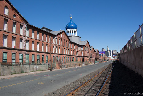
IMG_3376

I have long been curious about this distinctive building in Hartford, CT. I used to think the building was a religious structure because of the blue onion dome with gold stars (Growing up in the Hartford area, I found the building exotic and mysterious -- DB). But no, this is the Colt Armory, one-time headquarters of one of the world's most well-known gun manufacturers.

The dome, which can easily be viewed from route I-91 going through Hartford, was company founder Samuel Colt's idea. Some say that the dome is a tribute to Colt's early work with Russian businessmen. Others say it was just a dramatic marketing tool. Either way, it is a distinctive piece of architecture. The original armory burned down in 1864, three years after Colt's death. The new building was rebuilt by his widow, Elizabeth Colt, and was made to be fireproof and larger than the original. The design is said to be based on the styles of the Italian Renaissance.

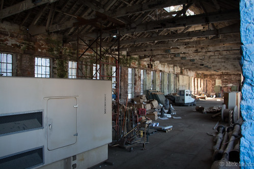
IMG_3406

(Inside the armory.)

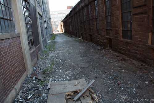
IMG_3385

(Rear of armory.)

The building and the surrounding area are being transformed into Coltsville National Park, after receiving congressional approval late last year. The park will honor the accomplishments of Samuel Colt. Plans for the park include a visitors center, an observation platform from which visitors can view the factory floor, and an elevator to the dome.

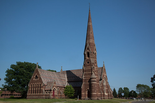
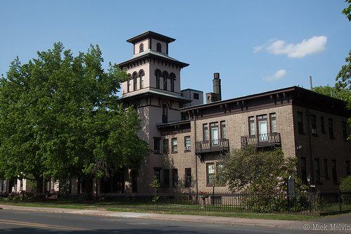
Plans are also in place to transform adjacent Colts Park, Armsmear (the residence of Samuel and Elizabeth Colt), and the Church of the Good Shepherd. It is the hope of Connecticut officials that the area become an educational center emphasizing Colt's contribution to firearms and the industrial revolution. The 260-acre Coltsville National Park is a work in progress, but we will be sure to keep you all posted.

Church of the Good Shepherd #1

(Church of the Good Shepherd.)

Armsmear#2

(Armsmear, one-time residence of Samuel and Elizabeth Colt. Now an apartment building.)

For more, read this article about the approval of the national park.

Thursday, June 18, 2015

UPDATE: Get Thee to a Nunnery

From Dave Brigham:

As promised, I'm back with an update on the former Sisters of St. Joseph convent property in Newton, Mass. (see January 31, 2015, "Get Thee to a Nunnery").

The 5.7-acre site, which has been on the market for years, includes the convent and a school building with a combined total of roughly 95,000 square feet. The convent includes 34 dormitory-style rooms, a chapel and covered parking, according to a real estate listing I dug up online.

The Sisters have rejected many offers from developers, because they wanted to see the site be used for community purposes. Well, thank you, Sisters, for holding out. This week, the City of Newton's board of aldermen approved the $17.3 million purchase of the property as part of a complicated, but much needed, upgrade to schools on the north side of the city.

The buildings will require some environmental remediation, and the addition of a gymnasium before becoming the new home of the Lincoln-Eliot School, one of many old and overcrowded schools in Newton. The current Lincoln-Eliot building would then become "swing space" to be used while the city renovates or replaces other schools.

The Carr School (which is across the street from where I live), a former elementary school that recently became the swing space to house elementary students while their schools are under construction, will eventually become the new home of the Horace Mann School, where my son went and which my daughter currently attends. The Mann school will function as a community center at some point down the road.

While all of these moves won't affect my daughter (she'll be in middle school by the time this plan plays out), it's a victory for younger kids in my neighborhood and surrounding areas. Too many of Newton's schools are overcrowded -- Horace Mann was built for no more than 300 students, I believe, and it currently educates in excess of 400.

I'm always happy to report good news, and especially when it doesn't involve a long-abandoned property getting turned into yet another upscale housing project.

Friday, June 5, 2015

The Ones That Got Away, Part III

From Dave Brigham:

(Photo from Citysearch.com)

I just noticed Veronica's Spa in Waltham, Mass., a few months ago. Located on a somewhat ugly stretch of Main Street, the convenience store (many older such stores adopted the term "spa" because they sold "healthy" soda-fountain drinks, or so the Internet told me) was opened some time in the 1920's or '30s, I believe.

As I often do with places that catch my eye driving around Greater Boston, I put this on my list of places to take some pictures of. Well, I drove by yesterday and recoiled in disappointment: the portico and cool sign on top have been razed. A guy on a ladder appeared to be replastering the building, which is no longer a vibrant red.

Before I got home, I knew I would post a little something about yet another "one that got away" (for more of these, see May 2, 2010, "The Ones That Got Away, Part I" and June 1, 2010, "The Ones That Got Away, Part II"). I wasn't, however, expecting to find out much about Veronica's Spa.

I didn't find a lot, but I did discover that the store was opened by a Turkish immigrant of Armenian descent named Veronica Sarmanian, nee Engelan. She came to this country after escaping the Armenian genocide, went through Ellis Island and then got married. She and her husband, Stephen, "pursued their career goals working long and hard hours until they could fund their own business, Veronica’s Spa," according to Veronica's obituary. She passed away in 2009 at age 103.

"Recognized as a pioneer in the burgeoning Rt. 117 corridor, Veronica is highlighted in Waltham’s history, called 'Waltham Rediscovered,'" the obituary continues. "Veronica was a feminist long before women’s rights were popular, pursuing a business life as well as a family."

I love digging up history like this. On my drives past the spa, I figured it was just another of countless convenience stores that are instantly forgettable the minute you walk out the door. I'll keep an eye on the place and see if they put the sign back up at least.

Here's another cool shot of the place from Flickr.

Thursday, May 21, 2015

I Seek Newton, Part 1: Lower Falls

From Dave Brigham:

Welcome to the first part of an occasional series about my adopted hometown, Newton, Mass. I've posted plenty here about Newton over the years, but I realized recently that there's so much to cover and it's the easiest place to drive around so I should conduct a more thorough review.

Settled in 1630, Newton spreads its population of about 80,000 residents across 13 villages. Newton Centre, Nonantum and Newtonville have significant commercial districts, while other neighborhoods, such as Waban and Lower Falls, have fewer retail outlets. Then there's Thompsonville, which I'm sure many people in the city have never heard of.

I'm kicking off with Newton Lower Falls primarily because I was most intrigued about it when I started thinking about this project. Cut off from the main body of Newton by Route 128, Lower Falls features many gorgeous old homes, a small shopping district along busy Washington Street (which continues into Wellesley in short order) and a beautiful church (St. Mary's Episcopal) and attendant cemetery.

Three years ago I wrote about a rails-to-trails project there as part of a post covering a handful of pedestrian crossings of the Charles River (see October 12, 2011, "Troubled Bridges Over Water"). The Lower Falls bridge was once part of the 1.25-mile branch of the Boston-Albany Railroad that ran from Lower Falls to the Riverside Yard, where the Massachusetts Bay Transportation Authority (MBTA) now runs trolleys and buses, and where companies including Greyhound and Peter Pan operate bus lines. The bridge has been rebuilt as a pedestrian connection into Wellesley.

(Former train bridge connecting Newton Lower Falls to Wellesley)

As I thought about walking around Lower Falls to get a better feel for the village, I recalled that several groups want to extend the walking path from the old bridge to Riverside Yard. I needed to find the route that extension would take to Riverside, where a developer plans in the near future to build apartments, retail sites and a parking garage on part of the land owned by the MBTA. As this development progresses, I'm sure the activist groups that want to extend the path -- the Newton Conservators, Newton Bicycle/Pedestrian Task Force and the Charles River Watershed Association, among others -- will continue to pressure the city, the Department of Conservation and Recreation and abutting neighbors.

To see what walking path supporters are up against, I walked along the bridge, crossed Concord Street and found myself staring at a no man's land about 40 feet wide running behind houses on both Baker Place and St. Mary's Street. I hoped to find remnants of railroad tracks or ties.

Wading in with camera in hand, I expected to encounter at least one neighbor barking at me from their back yard asking what the hell I was doing. I wasn't trespassing on private property, but I felt self conscious because the area has little cover from concerned residents. I could see right away that this project is going to face severe scrutiny and pushback. The area in question continues behind dozens of more homes along a few more streets (and along the backside of the Leo J. Martin Memorial Golf Course) before connecting up with an old train bridge that crosses Route 128 on its way to the Riverside Yard.

(Train bridge crossing Route 128, connecting Lower Falls with the MBTA's Riverside Yard.)

While residents will surely fight a path that will bring walkers, runners and cyclists through their backyards, I believe they'll also rue the loss of their dumping ground.

(Residents have filled in the former rail bed with major amounts of yard waste, from trees and shrubs to potted plants, as well as other refuse.)

I ventured only about 50 feet in before hitting this obstacle. Along the way I spied composting bins, discarded potted plants and piles of leaves that were obviously dumped from backyards. Alas, I found no sign of the Boston-Albany line, but I'm sure if the path gets approved and folks start clearing things out, they'll make a few interesting finds.

I decided to turn around, having satisfied my curiosity for the time being. That's when I made my own interesting find:

(Discarded Pacer moped.)

If anyone wants to restore a Pacer moped, you'll find this rusting junker about 25 feet into this suburban jungle.

During my short tour of Lower Falls, I spent time on another bridge over the Charles River.

(The Mary Hunnewell Fyffe Footbridge, which features a fish passage.)

This bridge connects the lower falls sections of Newton and Wellesley. There is a fish passage here, to facilitate interspecies communication.

I took a roundabout way to this bridge, because I was unfamiliar with the terrain. I cut behind the post office and an office building and found a path next to the river. I then traveled behind a senior living community, where I found this odd creature.

(Faux-ote.)

I've dubbed it a "faux-ote."

I didn't learn until after my trip that some of the buildings I passed behind, as well as others I checked out on a second visit, had amazing histories.

(Lower Falls Wine Co., formerly known as Boyden Hall.)

This building, which has housed Lower Falls Wine Co. for 75 years, once hosted theatrical performances and Catholic masses, as well as community-based gatherings such as voting and bandage rolling during World War I, according to the wine company's web site.

(Former Ware Paper Mill.)

Here is the former Ware Paper Mill, which was built in 1790 and was the first paper mill to be built on the banks of the Charles River, according to Wikipedia. These days, this building is occupied by a consulting firm, while other parts of the old mill contain a rug store and retail stores.

(Approximate site of former Wales's Tavern.)

On this spot (or someplace close by) once stood Wales's Tavern.

(Former firehouse and library, this building is now condos.)

This cool building with the unfortunate doors was once a firehouse, and subsequently a library. It is now condos.

Rounding out my trip, I walked along Grove Street and checked out the backside of the St. Mary's Cemetery.

(St. Mary's Cemetery.)

I'll keep an eye on the effort to extend the walking path from Lower Falls to Auburndale, which just happens to be the village that I'll feature in the second part of this series.

Wednesday, May 6, 2015

Roam If You Want To

From Dave Brigham:

Often times when I set out with my camera to take pictures for this blog, I have a destination in mind. I've made note of an aqueduct head house, a named building, an abandoned factory or a stretch of long-forgotten railroad tracks and circled back to document the place in advance of doing research.

Almost as frequently, I'm going somewhere -- my accountant's office, Target, dropping my son at an appointment -- and remember to bring along my camera bag, in case I have time to poke around looking for my favorite places on the fringe. While I love exploring with a purpose in mind, it's these wild goose chases that raise my excitement level to that of a little kid under the tree on Christmas day.

Sometimes I get a lump of coal in my Backside stocking. Other times I drive around, pass a few promising places but continue on hoping for the equivalent of a new bike or a Red Ryder BB Gun (look it up....), only to run out of time. On enough occasions, however, I stumble across some cool places to take some interesting photos. Not everything has a story that I need to research. I just like hiking around, exploring and finding the less-traveled spots.

Here are some of the results.

As part of my ongoing mission to document the Backside of my adopted hometown, Newton, Mass., I've come across places that don't easily give themselves away. I suppose a knock on the door might lead to an answer, but I'm not usually willing to do that.

This fancy, rounded bench looks like it's made of cement. The letters "PD" are inscribed on the lower left section. I spotted this seat as I was trying to figure out where the one-time Stanley Steamer plant on the Newton-Watertown line once stood. The bench is in the corner of the yard of a rundown house situated in the most northeastern point of Newton.

Does the "PD" stand for Police Department? Was this bench originally sited in front of a local constabulary? Or are the initials attached to a person? Lots of questions about this oddly located, uncomfortable seat.

Built in 1900, this two-family house is, like the property in the previous photo, located in Newton Corner. I like the look of this place, which was recently rehabbed. Stalking the house on Google Maps, I noticed while on "street view" that there was a historic marker of some sort on the house. When I arrived with my camera a day or two later, however, I noticed that the marker was gone. Again, I could knock on the door and ask about the house and any historic significance, but I'm not very comfortable prying into people's lives that way.

Recently, I was on the other side of town, the southwest section of Newton called Oak Hill. I'd picked up my tax return in nearby Dedham, and had some time to kill before picking my son up at school. It was cold and overcast, with light hail falling as I walked into the woods just over the border in Boston's West Roxbury neighborhood. The trees provided decent cover from the precipitation as I walked a trail along the fringe of a cemetery and the remains of the Brook Farm. Across a thin stretch of trees I could see the Baker Street Jewish Cemeteries, 42 individual cemeteries run by the Jewish Cemetery Association. The path took me right past the far southwest corner, where I easily scrambled over a low wall and took this picture.

I continued on the path to the outskirts of Millennium Park in West Roxbury.

This is obviously a major teen hangout. There are dirt bike trails winding through the trees, and the odd beer bottle and piece of trash here and there.

I'm drawn to places like this because I grew up in places like this. Sure, I get excited by checking out urban decay and dream about undertaking actual urban exploration, instead of just snapping pictures of the outside of dilapidated buildings. But as a kid I explored the woods and streams and railroad tracks near my home. Some people look at these environments and don't see much, but there's always more there than meets the eye.

OK, twisted vines and a dried out ear of corn aren't typically what I feature here. But these are the types of things other people overlook on their way past little patches of woods and tiny fields that don't look like much. I took these shots in Concord, right near a place called Brigham Farm, which has been operated by distant relatives of mine (whom I've never met) since 1824.

In nearby Sudbury, I stopped to take pictures of a long-abandoned place that I'd seen (and taken pictures of) a few years ago.

Known as Bowker's Store, this place in the northern section of town was among a few spots that sold all manner of goods, and served as gas stations and local post offices, too, according to the Sudbury Chamber of Commerce.

According to Geocaching.com, Mr. Bowker passed away in 1965 and a man named George Sharkey took over ownership of the store. Shortly thereafter, the store applied for (and was denied) a liquor permit. It appears to have gone out of business soon after, according to the Geocashing site.

Founded in 1639, Sudbury was the third inland, Colonial town established in the Massachusetts Bay Colony, according to the town web site. As such, the settlement has quite a lot of history related to Native Americans, the Revolutionary War and even slavery.

I've never seen a street sign like this. It's pretty cool.

Friday, May 1, 2015

Odd-Church-Dive-Barn

From Dave Brigham:

Dedham, Massachusetts, has an illustrious history.

From Wikipedia:

The history of Dedham, Massachusetts began with the first settlers' arrival in 1635. The Puritans who built the village on what the Indians called Tiot incorporated the plantation in 1636. They devised a form of government in which almost every freeman could participate and eventually chose selectmen to run the affairs of the town. They then formed a church and nearly every family had at least one member.

The early residents of town built the first American canal, the first tax-supported public school, run by Ralph Wheelock, and Jonathan Fairbanks built what is today the oldest wood frame house in North America."

The town center is beautiful, with historic homes aplenty and great commercial buildings and wonderful churches.

(First Church and Parish, Dedham)

There's a cool social club. Well, used to be.

(Odd Fellows Hall, Dedham. Appears to be empty.)

But you read this blog, you know what I'm looking for. I hunt around the edges. I look for stuff that other people pass by. The forgotten spaces.

(The Oasis, Dedham. Now closed.)

Shuttered last year, The Oasis was a dive bar that reportedly opened in 1972. I thought it was a private club, but I wouldn't have gone there even if I'd known it was a public joint. A sushi place is slated to open there, according to reports online.

My standard line about dive bars is that I picture a bunch of old guys in sleeveless t-shirts and women with beehive hairdos eating pickled eggs out of a jar on the bar top. I'm sure The Oasis fit that image to some degree, but after posting that impression about a one-time dive in Waltham, Mass., a few years back, some of the former patrons commented that The Reef was all about community and friendship (see August 25, 2011, "Goodbye Reef, So Long Bill"). Make sure you scroll down and read the comments.

The final shot I made was right on the border of Dedham and West Roxbury, a neighborhood of Boston that still maintains a lot of its "lace curtain Irish" feel. But along the commercial strip of Route 1, just past the Boston Trailer Park, West Roxbury looks like Anytown, USA, with its fast food joints, car dealerships, mattress stores and empty storefronts.

There's one empty lot, between a Pets Supplies Plus and Prime Toyota Boston. An abandoned McDonald's, which stood across the parkway from an operating Mickey D's, was torched two years ago on this spot. Currently, there is a proposal before Boston authorities to build on this site a kosher hotel, which I admit is something I've never heard of.

Here's what's left on the lot.

Not sure what to make of this old shed. The building is close to the parking lot for the former McDonald's, but also sits on the fringe of significant green space along the Charles River. I'm guessing it was once part of a small farm. I'll keep an eye on this....

For more posts about Dedham, click these words.

Thursday, April 23, 2015

Named Buildings of Newton

From Dave Brigham:

I defy you to find a town or city in these United States that doesn't have a building with a permanent name on it, or historical records showing that there used to be such a thing. Back when architects, builders and businesses believed in permanence, they carved names into stone, presuming that, like Stonehenge, these edifices would stand for eons. Speaking of hewing things into the living rock....


Spinal tap - Stonehenge by samithemenace

Anyway, as regular Backside readers know, I've been on an on-and-off quest to document named buildings in Greater Boston. I could pursue this forever, and perhaps I shall. As for now, I'm highlighting a few buildings in Newton, where I live. Backside fans can expect a greater focus on Newton in the coming months. I plan to feature each of the city's 13 villages -- information about their history, links to old photos and of course my photos of what I found scurrying around the edges.

For now, here are some of the named buildings of Newton:

(Newtonville's Orr Building, longtime home of Armenian/Middle Eastern restaurant Karoun. Go for the food, stay for the belly dancing. I have no idea who or what this building is named after, but I plan to find out what I can as I work on the Newtonville component of my above-stated project.)

(The side entrance to the imposing Masonic Temple in Newtonville. Home to the Dalhousie Lodge, the building was erected in 1896.)

(Former Claflin Grammar School in Newtonville, now apartments. Built in 1891.)

(Stevens Building, Newton Highlands. Built in 1888.)

See the four previous parts of my ongoing Named Buildings series: #1, #2, #3 and #4.

Wednesday, April 15, 2015

From Motel to Mall

From Dave Brigham:

After a few days hanging out in garish Panama City Beach (see March 17, 2015, "Take Me Down to Panama City"), I was ready for something a little more down to Earth. In pamphlets about things to do in the area, I saw mention of "historic St. Andrew's" in Panama City, which is a separate town from the beach community that has been in the news lately for some awful goings-on during spring break. We ate lunch at a great place in the St. Andrew's neighborhood called the Shrimp Boat and then drove around a bit before heading back to our hotel.

I took note of lots of places I wanted to take pictures of, and made a plan to return early the next morning. The one building of interest to Backside of America readers is the old Cabana Motel.

On this web site you can see what the motel looked like when it opened in 1960. The facility closed many years ago, but in 2008 there was a plan to develop the site into the Cabana Hotel, which would have transformed the motel into a sleek, chrome-trimmed destination (scroll down on the above web site). I'm assuming that the economic downturn put the kibosh on that plan.

Here's what the Cabana looks like now:

When I saw its condition and the sign advertising the Cabana Courtyard Mall, I thought, "There goes another cool old motel." But I was wrong. The owner of the Shrimp Boat is saving part of the old motel as part of a plan to convert the building to retail shops.

Here's a local news report (sorry, the embed feature on this didn't work).

I hope the redevelopment works out for this cool little section of Panama City, which also features some funky shops and restaurants, a strip club (Tan Fannies) and a museum dedicated to the area's publishing history.

Tuesday, April 7, 2015

Signs of Old Times

From Dave Brigham:

I've wanted to take this photo for a long time. I know, I know. Not much to look at. But I suspect there's significant history behind this simple sign.

I pass this apartment house at 117-123 High Street in Waltham, Mass., on a regular basis. After numerous trips, I spied this sign, but didn't think about it too much. Repetition pounded my head and eventually I thought, "What the heck is with that sign?"

Through online searches, I've learned that the building dates to 1900, and has 20 rooms. High Street connects one of Waltham's primary commercial thoroughfares, Moody Street, with neighboring West Newton. As such, it represented a vital route for the Waltham & Newton Street Railway service, which launched in the late 19th century.

This apartment house is located on the corner of High and Newton streets. I'm guessing this sign marked this building as the Newton Street stop for street railway passengers. But what was the building in 1900? Was it a hotel? A train station? I'll keep digging.

Meanwhile, more recently I spied two other signs in Newton that are railroad-related.

This wonderful old house features a "NEWTON CENTRE" sign that I presume came from the nearby Green Line trolley station of that name. There is a cool station building there (now housing the Deluxe Station Diner) that dates to 1890, the days of the Boston & Albany Railroad.

This sign is also on a great old house in Newton Centre. The Green Line trolley runs directly behind this house, which sits between the Newton Centre and Newton Highlands stations. The Grand Trunk Railway was headquartered in Montreal, but included subsidiaries operating in most of New England. The residents must be pretty big train geeks.

The Grand Trunk has come up twice before here on the Backside:

October 13, 2014, "Portlandia," in which I posted a picture of a former Grand Trunk headquarters in Portland, Maine.

June 20, 2010, "The Truth Behind Beautiful Ruins," in which Joe Viger mentioned that his father worked for Berlin (NH) Mills Railway, which connected paper mills to outside carriers including Grand Trunk.

UPDATE: Guido's Court

From Dave Brigham: Longtime readers of this blog might recall that every once in a while I check in on a quaint campo di bocce in Brighto...