Monday, November 21, 2016

The Buildings That Time Forgot

From Dave Brigham:

I haven't posted as much about the backside of downtown Boston as I could have over the years. Usually when I'm in the city it's on a subway trip with my son, Owen, and I have limited time to seek out the abandoned, forgotten and dilapidated. For a list of posts about the Hub, see the end of this post.

Recently, however, I was on the city's wonderful Rose Kennedy Greenway with Owen and a few of his friends, and was able to snap pictures of two old buildings, one that's in a tight squeeze, and one that's been knocked to its knees.

Built in 1899, this four-story Financial District building has an electricity substation right next door. I remember walking past this place 20 years ago when I worked in the area, and marveling at how out of place it looked even then. Now, with skyscrapers rising downtown and in the Seaport District, this place is even more of an anachronism.

To see what it looked like when I was a younger man, read this 2007 article (which is truncated unless you're a subscriber) and look at the photo, which indicates a hardware store closed in 2006 when the owner died.

The current owner of the building set a selling price of $16 million four years ago, according to a 2012 Boston Business Journal article. That mark represented more than 28 times what the owner paid just a year prior, the article indicated. To be sure, real estate in this area, close to the Greenway, the harbor and the Seaport District, has shot up in value in recent years. But what can you do with this building or its footprint?

I couldn't find any news or real estate updates about the place. Maybe a pencil tower will rise here one day.

This is the other building I photographed, which I also recall from my days working downtown. While the hardware store surely has some good memories tied up in it, and certainly once fit more seamlessly into its neighborhood, there's no doubt that the building above, on Broad Street, was an important part of this area.

Most recently this building and the one next to it were home to The Littlest Bar and The Times Irish Pub & Restaurant. I never went to either, although I did go to The Littlest Bar in its original location in Downtown Crossing many years ago. The Times is moving to 99 Broad Street, not too far from another well-known bar, Mr. Dooley's. The Littlest Bar may move to a new location, although that announcement hasn't been made.

Built in 1805 and located hard by the Greenway, the Bulfinch building was originally a warehouse for goods coming off nearby wharves (back before the city installed fill to make itself bigger), according to this Boston Globe article, which you should read. According to the article, the outside of the building was declared a landmark, but the interior wasn't, because it had been changed significantly over the years.

After negotiating with the city's Landmarks Commission, the developer, New Boston Ventures, agreed to keep the portion of the building that you see above, and to incorporate it into a 12-story condo development (read the Globe article to see an artist's rendering of the new building married to the old structure).

Boston used to be known for cool bars in old brick buildings, and there certainly are some of those left. But it's a new millennium and the city is thriving and growing and glass and metal are of course the favored mediums. I'm glad the Landmarks Commission made the developer keep at least a part of the city's history intact, but it will be nothing more than a mere curiosity for residents, visitors and tourists unaware of the building's importance to Boston's past.

As promised, here's a list of other downtown Boston posts from over the years:

August 30, 2010, "Going Underground," about a trip on the subway with my son.

January 25, 2014, "Last Building Standing," about a remnant of the old West End.

August 19, 2015, "Misfit Garage," about a municipal garage slated to be torn down soon and replaced with yet another high-rise condo building.

October 19, 2012, "Window Dressing," about the former Dainty Dot Hosiery building.

February 10, 2011, "Up From the Basement?," about the long-empty hole where Filene's Basement once stood, and which is now a high-rise.

Tuesday, November 15, 2016

Water You Talking About

From Mick Melvin:

Untitled

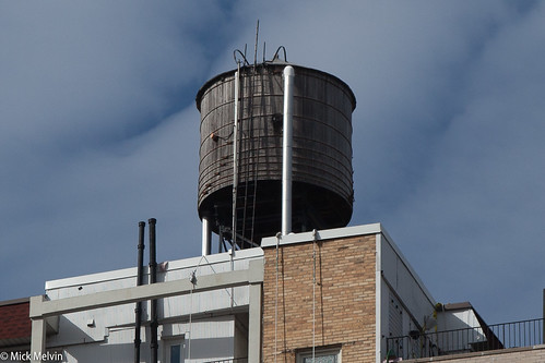
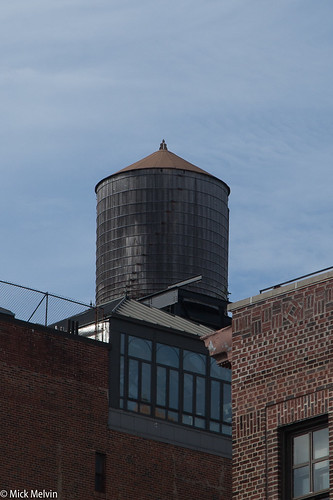
I was surprised by the amount of wooden water towers that dot the skyline of New York City. I was recently on the Upper West Side visiting friends and noticed these old-looking water towers.

Every direction that I looked I could see water towers. Most of the towers are plain wood, but some have a little writing on them. I did a little research and found out that these water towers last for 30 years and most of the towers are built by two companies. When you are in NYC, look up and I’m sure you will see these timeless icons.

Untitled

To learn more about water towers, check out this AM New York article.

Wednesday, November 9, 2016

Brigham in Waltham, Part I

From Dave Brigham:

I've written about two dozen posts here over the years about, at least in part, Waltham, Mass. (check out these search results). Just next door from my adopted hometown of Newton, Waltham is a former mill city of just over 63,000 residents. Known as the Watch City, Waltham was home to the Waltham Watch Company, the first company to make watches on an assembly line. The city was also home to textile factories in the 19th century. There are plenty of old buildings downtown, in addition to former factory worker housing, churches, old and current railroad tracks and related facilities, diners and plenty of other sites that we here on the Backside love to check out.

Just as when the mills were humming thanks to immigrant workers, Waltham is still a city that welcomes those from other lands. As of the 2010 census, nearly a quarter of the city's residents were foreign-born, many from India and Guatemala, according to Wikipedia. I can tell you from casual observation that six years later, that percentage has surely risen.

This is the first of a three-part series about the city. You will see a few dozen photos and learn about abandoned buildings and repurposed structures alike. You will gain knowledge about classic churches and long-neglected railroad right-of-ways, as well as see ghost signs and out-of-the-way monuments and murals.

As with other town and city surveys I've conducted (see list at the bottom of this post), this post is by no means an exhaustive tally of all of the cool and historical aspects of Waltham.

OK, let's get started.

According to the Waltham Land Trust, this little building holds electrical controls for Waltham Common, the park behind city hall bounded by Main, Moody, Carter and Elm streets. I love how it's styled like a classic New England church, with white clapboard siding and a steeple.

Just to the left of this quaint building sits a memorial to a man who had no connection whatsoever to Waltham or, for that matter, Massachusetts. Dag Hammarskjöld was a Swedish diplomat and the second secretary-general of the United Nations, serving in that role from April 1953 until his death in a plane crash in September 1961, according to Wikipedia.

Just a month after Hammarskjöld's death, the Waltham Junior Chamber of Commerce installed this plaque. Although the diplomat had no ties to the Watch City, the CofC members obviously felt it necessary to honor the man who had sought to bring peace to the world for eight years. He was en route to Congo to negotiate a cease fire when his plane crashed under mysterious circumstances, according to Wikipedia.

Turn east from the little house and the Dag plaque and you'll see this Queen Anne-style building, which is stunning now even its decline.

Built in 1880, this building was once known as the Elm Street Music Hall. The theater's occupancy was more than 1,000 people, and they saw speakers including Mark Twain, Oliver Wendell Holmes and Ward Beecher, according to this article, which is about the building owner's plan to restore the facade. The theater burned down in 1932 after hosting music and vaudeville performances, as well as movies, leaving the facade, which houses retail stores on the first floor and apartments above.

When I checked it out recently, there was work being done on the roof, so I believe the restoration mentioned in the article is under way. Can't wait to see what it looks like when the project is completed.

We skip now just a short distance to the place known by my wife and her family as the Superdome church. Or is it the UFO church?

Dedicated in 1964, Sacred Heart Church is unlike any church I've seen. "The style was not to be bound by popular tradition, not to be merely modern - it was to be a glimpse into the future," according to the church's web site. I was in the wedding of my good friends Jim and Nikki here several years ago.

We're looking here at, of course, the backside of the church, which is the second structure to stand on this property. The original church, built in 1924 for a largely Italian immigrant parish, now houses CCD classrooms and the church hall.

About a half mile away is an imposing brick mastodon of a building, St. Charles Borromeo Catholic Church. Built in 1922, technically the building is an example of Italian Renaissance Revival architecture.

(By User:Magicpiano, Wikimedia)

Listed since 1989 on the National Register of Historic Places, the church has no steeple or stained glass windows, but it has one architectural feature that caught my eye.

At Main Street's Christ Church Episcopal, which opened in 1898 and is also on the National Register, I saw this proud, yet forlorn, detail.

Waltham is filled with congregations, including one whose church has an interesting past.

Ministerio Evangelico Rios de Agua Viva (Evangelical Ministry Rivers of Living Water) is located in the former Hamblin L. Hovey Memorial Building. Outfitted with a 1,300-seat auditorium when it was constructed in 1935, the Hovey building had a fully functional stage and an orchestra area that could accommodate 500 seats, according to the web site for Hovey Players community theater group, which at its inception performed in the building. In 1952, the International Brotherhood of Electrical Workers bought the building. In 1998 a Buddhist group, SGI International, acquired the building and walled off the balcony while converting the auditorium to a temple, according to the Hovey Players web site.

I'm not sure whether SGI still owns the building.

Across the street from the Hovey/church building sits the Jonas Willis Parmenter Home.

This building in and of itself is nothing all that interesting, but history doesn't always come in beautifully decaying packages or awe-inspiring architecture. History is each and every person living their lives, making decisions, going to work, honoring their loved ones. Parmenter was a coal, wood and brick dealer, according to the Hovey Players web site. He was also the father-in-law and employer of Hamblin Hovey, namesake of the memorial building talked about above.

In 1889 Hovey built the Parmenter Block not too far from the site of the Hovey Memorial Building and the Parmenter Home. Named in honor of his father-in-law, the building had retail space on the ground floor and an auditorium and banquet hall on the two floors above, according to Melissa Mannon's "Images of America: Waltham," from Acadia Publishing, excerpts of which I found via Google Books.

Hovey died suddenly in 1904, according to the Players web site. In 1935, the Parmenter family commissioned several buildings, two of which were named in Hovey's memory: the memorial building and a dance hall that's been gone for some time. This is the kind of stuff I find increasingly fascinating, the forgotten history of cities and towns, the people behind named buildings, the citizens who built a place and left behind legacies that benefit future generations.

Every city and town has hidden history, of course, but in old mill towns like Waltham it's easier to find. One day, driving through the city on a route I had done dozen of times, I just happened to look to my left and see this place, as if for the first time.

What caught my eye was the sign across the front of the porch: Gilbrae Inn. I knew there was no way this was an active hotel, so I took to the Internet. Listed on the National Register of Historic Places, the inn was built by the Boston Manufacturing Company, which built the world's first spinning and weaving factory in Waltham. The inn was a rooming house for BMC employees, and was built sometime between 1827 and 1854, according to Wikipedia (not sure why a specific date is so hard to pin down). It is the only surviving boarding house built by the company, according to Wikipedia.

I've located one other 19th century building that took in guests.

Known as the Prospect House, this former hotel and tavern is now an apartment house, according to Wikipedia. Built in 1839, it too is on the National Register.

The penultimate stop on this first part of a three-part installation is a cozy little social club. Maybe they'll invite us in for a drink....

Founded in 1886, the Piety Corner Club is Waltham's oldest neighborhood association, according to Waltham-Community.com. The neighborhood is so named because it was home to several ministers at some point, most likely in the 19th century.

Finally, a rather new-looking sign commemorating a historic event.

Located at the corner of Route 20/Weston Street and the very short Tavern Road, this marker speaks of an event I've written about before, Gen. George Washington's march from Virginia (I think) to Cambridge, Mass. (see April 20, 2016, "Washington Walked Here"). Research online didn't bear any fruit, but I'm guessing there was a tavern near this location and maybe the good general popped in for a quaff or two.

In the next two installments of this series, I will cover railroad, diner and oddball house/retail stuff, as well as ghost signs, murals and a few other things.

As I mentioned at the top, I've also written and taken photos covering other towns in eastern Massachusetts:

December 9, 2015, "Scenes From an Old Shoe Town," about Hudson, Mass.

January 27, 2016, "Finding Hope, But Losing a Mainstay, in Clinton," about Clinton, Mass.

March 30, 2016, "Big Walk in Littleton," about Littleton, Mass.

Thursday, November 3, 2016

A Path! A Path!

From Dave Brigham:

This is about the most well-lighted tunnel I've ever seen. Located in Brookline, Mass., the Clinton Path underpass allows travelers to cross from Beacon Street toward the Fisher Hill neighborhood, under the MBTA trolley tracks.

For more about the path, read this short article.

To read about other tunnels, check out these links to our archive:

January 27, 2016, "Finding Hope, But Losing a Mainstay, in Clinton."

September 20, 2015, "I Seek Newton, Part II: Auburndale."

November 20, 2011, "History Flows On, Part II."

Now, as for the title of this post. It comes from one of the touchstone movies of my life, "Monty Python and the Holy Grail."

Thursday, October 27, 2016

House That Onions Built?

From Rich Morahan:

(I love getting unsolicited material. Today's post comes from my father-in-law, who took the pictures and provided the basic information about the location. I did a little research and writing to flesh it out. -- DB)

Anticipation sets in. You can sense at this point that there's history here.

Sure enough. Located along Pulaski Highway in Pine Island, New York, this place may have been migrant housing at one point. I have driven by it for a decade or two. They never tear anything down around the very prosperous onion capital of the world.

Go ahead, shed a tear.

Friday, October 21, 2016

Rockin' in the Dungeon

From Dave Brigham:

I've been wanting to walk through this door for a few years, ever since I stumbled across mention of Dungeon Rock in Lynn, Massachusetts.

After double-checking on the Friends of Lynn Woods web site that the door would indeed be open, I hopped in the car with my kids and made the 40-minute drive from our home. I'm happy that my kids, aged 9 and 14, are at the age where they don't complain too much about doing stuff like this. "It's just a short walk in the woods," I told them, hoping I was right. "And then there's a cool cave."

Turns out, I was right. Following a map kindly provided at the entrance to the park, we walked for maybe 15 minutes through some beautiful forest, before cutting over on a trail heading toward the infamous Dungeon Rock. Up an easy set of stone steps we found our destination.

I don't know the geological history of this spelunkers' paradise, but the Friends of Lynn web site has a fairly detailed account of the area going back to 1658. Here's how that story begins:

"Late in the summer of 1658, a sinister ship appeared in Lynn Harbor. The ship was painted black and flew no flag. Word spread quickly among the citizens of the small town of Lynn, Massachusetts: There were pirates in the harbor! A boat was lowered from the ship, a chest was loaded into the boat, and four oarsmen rowed it toward shore. The boat headed up the Saugus River and landed near the Saugus Iron Works. The next day, workers found a note attached to a door, asking to purchase a supply of shackles, hatchets, shovels, and other tools. The note promised that if the requested tools were manufactured and left at a secret location, then a supply of silver would be left in exchange. The tools were made and paid for as promised."

You can read the rest of the account at the Friends of Lynn Woods web site.

My kids and I ventured cautiously through the door, no clue in our heads about what awaited us. A few feet inside the doorway is a staircase. With my son shining his cell phone flashlight ahead of us, I tentatively started down, my kids right behind me. At the bottom of our short descent, we landed on some somewhat slippery rocks. I took my son's phone and shined the light deeper into the cave. I couldn't see much, but could tell the cave went down more and was much bigger than I'd assumed.

I made the executive decision that although we'd only explored about 20 feet into the cave, we would turn around and head back up. If I'd been on my own, and had a proper flashlight and better footwear, I would've pushed on a bit more.

When I have more time, I'll get back to the Lynn Woods, to check out the stone tower, the rose garden and the wolf pits.

Sunday, October 16, 2016

Gone Depot

From Dave Brigham:

In a hurry to take pictures of an abandoned municipal pool (see October 10, 2016, "Everyone Out of the Pool!"), I stopped in my tracks at this beautiful mural.

The Faneuil Depot, named for the nearby Faneuil Street (which was presumably named after Peter Faneuil, of the famous hall in Boston), stood on this spot from 1882 until 1962, when it was torn down to make way for the Massachusetts Turnpike. The mural was painted by Joshua Winer on a bridge abutment for that highway, which is a nice touch. For more about the depot and the surrounding area of Boston's Brighton neighborhood, click right here.

Monday, October 10, 2016

Everyone Out of the Pool!

From Dave Brigham:

When this municipal pool building in Boston's Brighton neighborhood was built in the 1950's or '60's, the architect didn't scrimp on cool design features. Unfortunately, nobody inspired by this fish can swim at the pool anymore.

Shuttered four years ago due to low attendance, high cost and safety concerns, the pool has been slowly decaying ever since, and probably for a while before it closed.

There are other public pools and spray parks not too far away, with more parking and better locations than the Brighton pool, which is squeezed between the Massachusetts Turnpike and a very busy Nonantum Road. I imagine the state will either tear this facility down in the near future or just start storing construction equipment there.

Monday, October 3, 2016

Bourne Identity

From Dave Brigham:

I'll say right up front that this post won't match the headline. Well, not exactly anyway. This is just a little piece about Bourne, Massachusetts, the first town you hit when you go over the Cape Cod Canal on Route 25. It's not an exhaustive review of the backside of this lovely town, nor is it a place where you'll find anything about Matt Damon, Julia Stiles or Walton Goggins. But I'll give you this:

Every summer for the last 14 years my family and I have vacationed in Pocasset, a beautiful little village in Bourne. It's a sleepy place with a few small restaurants, some modest hiking trails and great sunsets over Buzzards Bay. This year, for the first time, I decided to poke around a bit into the underbelly of Pocasset and some other parts of Bourne. Because I was on vacation, I had limited time, so I hardly covered the entire town. But here's a bit of what I found.

The entry gate above says 1896, but PocassetCemetery.org indicates the first burial dates to 1835. The web site is a labor of love, and includes genealogical information about the families buried within.

There are numerous cool gravestones and statues both old and new.

While the newer part of the cemetery is fairly well maintained, the older section could use some tree pruning.

Not everyone, however, has a cool headstone.

After leaving the cemetery, I drove aimlessly around and ended up at the Aptuxcet Trading Post Museum, which is very close to the Cape Cod Canal. I had no interest in the museum, but dug the mural painted on a bridge abutment for the active train tracks near the museum.

The last stop on my short tour was Little Bay hiking trails, which run between Shore Road and Buzzards Bay. The hike isn't much, and there are no old structures that I saw, but I always like it when an active railroad line, albeit a lightly used one that's mostly for trash runs, winds through my world.

Monday, September 26, 2016

I Seek Newton, Part V: Oak Hill

From Dave Brigham:

I get a bit frustrated from time to time as I put together this series. Sometimes I realize after the fact that I've mistakenly placed a building or park in the wrong Newton village (the former Working Boys Home, currently the Jewish Community Center, and which is featured below, could be in Oak Hill, Newton Highlands or Newton Upper Falls, depending on which history you read, and how you interpret various maps). There are no hard and fast boundaries in the city; I do my best.

Other times I become a little bummed when I realize I'm too late (usually waaaaaay too late) to get pictures of something before it's torn down, or that I can't gain good access to snap pictures without trespassing on private property, such as was the case in Oak Hill with the former New England Peabody Home for Crippled Children. Situated on the former estate of a surgeon associated with Harvard University, the Home was converted by "This Old House" into condos in 1979. You can read more about this site and see photos, below.

Once in a while, though, I get pissed, as I did about a mostly insignificant path in Newton's Oak Hill village, the subject of today's post.

After roving back and forth across this quietest of Newton's villages, I did a bit more research and learned of something I'd overlooked called the Oak Hill Pathway. I knew exactly where the short trail was located, so I struck out to hike it and take some photos.

I was, however, thwarted in my attempt. Unlike other small conservation areas in the city, this one has been allowed to grow over, thereby restricting access. The public path crosses private land on its way from a dead-end street to the top of Oak Hill, so I wasn't surprised, just angry. From the top of the hill, according to the Newton Conservators web site, you can see the Charles River and Blue Hill, which is located several miles away in Milton, Mass.

I emailed Beth Wilkinson, the president of the Newton Conservators, to ask about the pathway. In her response, she CC'd Jennifer Steel, the city's senior environmental planner, who replied that while Newton granted a public access easement, "the deed doesn’t mention obligations of maintenance or enforcement." In other words, citizens have a right to walk on the path, but the private property owners aren't required to make it accessible.

All is not lost, however. Steel said she encourages the Conservators or other parties to "take on the task of surveying, staking, creating … and maintaining … a path." Wilkinson said she hopes that perhaps a Boy Scout troop or civic-minded high school students might take on the project.

(The Oak Hill Pathway is currently blocked. Interested visitors might want to bring a machete to make passage easier.)

(The sign for the pathway, teasing potential hikers.)

Still, there's plenty of backside to be found, and explored, in Oak Hill.

The southernmost village of Newton, Oak Hill has only the sparest of a town center and no industry or rail access. The area does contain one of the nicest walking trails the city has to offer; the city's last working farm; a mansion turned home for sick children, turned high-end condos; and a post-World War II housing development unlike anything else in Newton, among many other features.

Welcome to the fifth installment in my ongoing series about the villages of my adopted hometown of Newton, Massachusetts. For a list of the previous installments, see the bottom of this post.

A largely rural community until the 1940's, Oak Hill was home to several large farms and estates, including ones owned by families such as the Stones, Hydes, Wales, Appletons, Shaws, Wades and Bigelows. These properties have been turned into condos, golf courses (the Charles River Country Club opened in 1921 on the former Wade property, but the original house burned down), college property (Mount Ida College) and conservation areas in the past century.

Let's start with the fantastic Helen Heyn Riverway. Named for a founding member of the Newton Conservators, the riverway was constructed, according to the Conservators web site, through a partnership between the Conservators, the Newton Parks and Recreation Department, the State of Massachusetts Department of Conservation and Recreation, the Newton Conservation Commission and something called the Newton Knights of Tunsion.

(I had to find out who in the world the Newton Knights of Tunsion are. Here again, Newton Conservators President Beth Wilkinson was happy to help. She had no idea this shadowy group was referenced on her group's web site, so she did some digging. From one of the guys who helped clear the riverway path, she learned that the group's name is the Newton Knights of Tumsion (with an "m"), a "group of characters, who prefer to remain anonymous." So it's a made-up name for some good-hearted folks who helped do the dirty work of making the path passable.)

The path and adjoining woods and wetlands encompass 30 acres between the Charles River and, at various points, an office park, a private Jewish day school, Mount Ida College and residential neighborhoods. I discovered the path, as I often do, by searching on Google Maps. I started my hike from the southwestern tip of Oak Hill Park, a planned community that I'll get to a little further down. There were a few whimsical, man-made touches as I walked along: a rope swing hanging from a tree, some broken-down chairs. Frolicking by students from the nearby college, I assumed.

The path led me through a boggy section toward the banks of the Charles. And there I took a picture that has become one of my favorites of all time.

It was so peaceful down here, especially in the winter, I can see why someone brought a chair down to contemplate life.

The path connects to both Millennium Park and the historic Brook Farm in Boston's West Roxbury neighborhood. Across the Charles is Cutler Park, which I've written about before (see November 20, 2011, "History Flows On, Part II," and December 6, 2011, "History Flows On, Part III").

The riverway sits on land once owned by Robert Gould Shaw II, a Mayflower descendant whose cousin of the same name (minus the "II") is famous for leading the first all-black regiment recruited in the North during the Civil War, as seen in the movie "Glory." RGS II, as he was sometimes called, was a wealthy landowner and socialite (read: idle rich layabout) who died in 1930 at the age of 58, according to Wikipedia. By that time the family fortune -- amassed thanks to mining investments -- had vaporized. The family sold the "vacant and decaying estate" in 1939, and part of the property became the new campus for Mount Ida College, according to Wikipedia (Oh, how I would have LOVED to explore that estate in the '30s!). Another part of the estate was sold off for the Wells Avenue office park.

(Stone walls along the Helen Heyn Riverway.)

(A bridge leading from the riverway across a small brook and into the Wells Avenue office park. The path goes through the park a short distance before curving back toward the river. There has long been a plan to build a crossing over a marsh, thereby eliminating the need to walk through the park.)

(Getting closer to the Newton/Boston border, I came across this tree.)

(On the outskirts of the Oak Hill Park development, just off the riverway, sits an antenna for WUNR, "one of Greater Boston's oldest ethnic radio stations," according to its web site.)

Oak Hill Park was developed in 1948 after the City of Newton took the land by eminent domain (formerly the Estes and Wiswall farms and a deserted gravel pit, according to the Internet) with the goal of building a planned community for veterans returning from World War II. The city built more than 300 homes and, eventually, a school and small shopping center (the school is now a private Jewish school; the shopping center is fairly quiet). Several paths run between streets and behind houses, giving the neighborhood a special sense of connection. There is nothing like this in the rest of the city.

(One of several paths in Oak Hill Park; the paths are named for Newton servicemen lost in the war.)

(The former Oak Hill branch library, now the Shuman Center, which serves as home for the neighborhood association.)

As you would expect in a planned community built in the late 1940's, the homes of Oak Hill Park are modest. Well, most of them. In recent years, as in every village of Newton, Oak Hill has fallen victim to The Teardown (see March 18, 2011, "Anatomy of a Teardown," and May 9, 2016, "Shedding Tears (Sometimes) for Teardowns," which features photos that your are about to see below.)

Here's a house that hasn't changed since it was built nearly 70 years ago.

And here's a house that has either been heavily modified or possibly replaced a smaller one that was torn down.

This one is much larger than abutting homes but isn't monstrous; there are more egregious examples sprinkled throughout Oak Hill Park. This type of mega-house development doesn't sit too well with many in the area.

Still, there is more open space in Oak Hill than in any other Newton village, although not all of it is accessible to the public, as I ranted about above.

The last working farm in the city, Newton Community Farm operates a Community Supported Agriculture (CSA) program, donates produce to various food pantries, offers classes and volunteer opportunities and hosts dinner events. The site has been farmed for 340 years by settlers, according to the farm's web site.
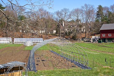
The property abutting the farm has a beautiful expanse of grass in front of it, but the only folks who can luxuriate in it are residents and guests of the high-priced townhouses hidden behind the club house.

Prior to being sold for townhouses, the estate was owned by the Lacy family, whose patriarch was an executive with the Filene's retail chain, according to this extensive blog post about the Angino family, which sold their farm to the City of Newton to create the community farm.

On the opposite side of Nahanton Street from the community farm sits an expanse of woods that once also belonged to the Shaw estate mentioned above. While part of that land was turned into the Mount Ida College campus, and another section into an office park, yet another piece became the Nahanton Woods condo development. You know me: I don't care about that. I care about the woods sitting in between the road and that development. I walked along the road, confident I'd find something worth my time. And I did.

Hard to tell from this photo but this is a small cellar hole. I have no clue how old this foundation is, or what was here. I'm guessing it was a small outbuilding for a farm on the Shaw property, perhaps even part of a stand where fruits and vegetables were sold, seeing as it's so close to the street.

As I said, Oak Hill was farming country up until the middle part of last century. In addition to farms owned by often well-to-do families, there was the poor farm run by the City of Newton. Built in 1900, the farm was the third such facility in the city (the first one was in Auburndale; the second in Waban). For more on the farm, see this article and this blog post.

The farm closed in 1964 and was torn down in 1976. The only extant building on the property is a tool house built in the late 1930's.

(Former tool house at the site of Newton's former poor farm.)

There are ruins on the site, however.

On the grounds of the former farm sit a soccer field, hiking trails and community garden plots.

(The community farmers use a variety of whimsical and practical ways to define their spaces and store their supplies.)

Adjacent to the old farm site is the Leventhal-Sidman Jewish Community Center, the grounds of which include the former Working Boys Home building.

(The former Working Boys Home is now the Jewish Community Center.)

Built in 1896, the home was an orphanage run by the Xaverian Brothers, according to Wikipedia. The home fell out of use in the 1970's.

I'm not sure what was on the site of the JCC prior to the Working Boys Home, but I stumbled across what appears to be an old stone wall, which I'm guessing was a property marker for another farm.

Just a short drive from the farm/JCC area sits a building that was once home to the Peabody Home for Crippled Children (read this article to learn more about the home). Built in 1886 as a private summer home for Harvard surgeon James Bigelow, the site served as the Peabody Home from 1895-1961. In the early '80s, WGBH's "This Old House" converted the building to condos.

I'd love to get a picture of the former estate, but without permission, the best I could get was the driveway into the property. Just up the street is the Oak Hill Pathway I mentioned at the top of this post.

(Driveway to condos in the former Peabody Home for Crippled Children.)

On the extreme eastern end of Oak Hill, bordering Boston's West Roxbury neighborhood and the city of Brookline, sit two conservation areas, one of which is unfortunately being developed as I write this. The larger one, Saw Mill Brook Conservation Area, is a nice spot with puddingstone piles and walls, and a burbling brook. As you can guess by the name, at some point there was a sawmill here, although I haven't found out much about it.

(Puddingstone wall remnants in Sawmill Conservation Area.)
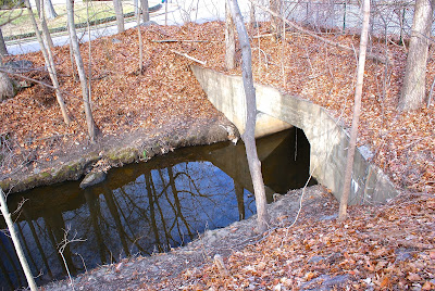
(The brook at Saw Mill Brook Conservation Area.)

Across a small side street sits Kesseler Woods, an area that was once considered for development as an energy facility by NSTAR, the successor of Boston Edison and predecessor of electric and gas company Eversource. The land was sold to a developer several years ago, with the City of Newton purchasing a smaller part to maintain as a conservation area. A small development went in a few years back, and a much larger one is currently under way.

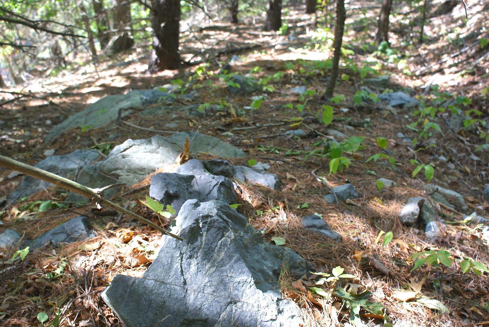
The photo above shows the southern tip of the Kesseler property, just across Vine Street from the Saw Mill area. I'm not a geologist, so I don't know what to tell you about these stones other than that they surely used to be part of a structure, whether a house, mill building or wall.

Wrapping up my tour of Oak Hill (although this site might actually be in Newton Highlands) is a little conservation area called Oakdale Woods. I passed this spot quite a bit last year while driving my son, Owen, to school, and figured there wouldn't be much there. But I was wrong.

Acquired by the city in 1979, this small (2.5 acres) refuge sits hard by the very busy Route 9 but, according to the Newton Conservators web site, has served for years as a spot "for winter sledding, acorn fights, and informal camping."

(I love paths like this leading from neighborhoods into small suburban oases.)

(Oakdale Woods is squeezed into the neighborhood. According to the Newton Conservators web site, the spot was at one point slated for development, but the steep cliff, large boulders and outcroppings of Roxbury Puddingstone made it untenable.)

The conservators take good care of this quaint park. There is a neat path and small steps made of bricks. Someone has built a lean-to, and there is evidence of a more permanent structure.

(Remnants of a chimney, perhaps?)

As with the village of Waban (see link below), I found Oak Hill to be initially underwhelming. I didn't think I'd find much of interest to myself or Backside readers. But I followed my mantra -- Get out of the car and walk around! -- and discovered some cool features.

Here are links to the previous posts in this series:

Part IV: Waban.

Part III, Newton Highlands.

Part II, Auburndale.

Part I, Newton Lower Falls.

Next up for the series: Chestnut Hill (I think).

Way Down Yonder in Pawtucket, Part I

From Dave Brigham: I apologize in advance for this, but I often feel the need to explain my headline choices: I'll admit that befo...