Monday, February 29, 2016

Shuttered Asylum

From Derek Watt:

Medfield State Hospital, originally Medfield Insane Asylum, was established in 1892 and open from 1896-2003. Built in the then-popular “Cottage Plan” style, where dozens of individual buildings served a specific need or patient type, each side of the property featured buildings arranged in a mirror image, one side for men, one for women. A chapel, administrative and other general purpose buildings were located in the middle.
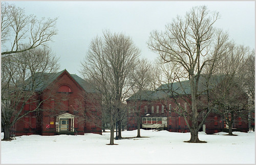
MSH-Winter15 14

Much like other state-run hospitals of the time, Medfield was self-sufficient (see August 23, 2010, "You Don't Have to Be Crazy to Live Here, But It Helps," a headline that I regret writing -- DB). A power plant situated on the edge of the property provided electricity and heat. Hundreds of acres of fields provided food for the staff and patients. Medfield’s farm operations were so successful that in some years, a surplus of food was generated and sent to other state hospitals in Massachusetts. At its peak, Medfield housed more than 2,300 patients. Hundreds of staff members also lived on campus in large staff dorms flanking the outer edges of the property.

Changes in psychiatric care during the 1950s with the introduction of drug-based therapy, coupled with new legislation around the treatment of mental illness into the '60s, led to a steady decline in patient levels. In the late 1970s, records indicate that buildings on campus started to become shuttered and abandoned. This trend continued until the hospital was finally closed for good in 2003.
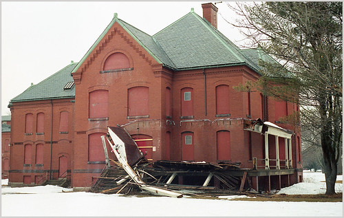
MSH-Winter15 01

In 2008 Medfield was one of the primary filming locations of the movie "Shutter Island" (see August 27, 2010, "Shuttered Island," about how Boston Harbor's Peddocks Island was also featured in the Martin Scorsese movie).

The state of Massachusetts retained ownership of the property until 2014, when it was sold to the town of Medfield. Currently the town is investigating various options for reuse and redevelopment of the property. The hospital grounds are currently open to the public from dusk to dawn.

All of the pictures featured here were taken from 2014-2016.

Tuesday, February 23, 2016

A Slice of Heaven

By Mick Melvin:

The pictures accompanying this article are of one of my favorite spots in Hartford, CT. The place has had a facelift since I first came upon it when taking photos back in 2010. The location was once the site of a basketball court, a chess playing area and two buildings (I'm not sure of their use).

It is now the site of Heaven Skateboard Park. It is located across the street from the former Butt Ugly Building location on the corner of Trumbull and Main off of Route 84 (see August 15, 2010, "The Butt Ugly Building"). The Hartford Yard Goats minor league baseball stadium is being erected across the street from the park (I eagerly await the chance to see an oddly named minor league team play so close to my mom's house -- DB).

What actually caught my attention back in 2010 was the awesome graffiti at the site.

I then noticed the basketless basketball court and the makeshift skateboard ramps.

There is graffiti on just about everything at the site (walls, doors, asphalt, tables and chairs). The tables you see in these pictures are actually chess tables.

I remember in the '70's as a child, seeing people play chess outside in the park when we visited NYC. I can only imagine this site bustling with people when it was first built. As you can see, the chess tables are in disrepair and covered with graffiti. I can't tell you the last time they were actually used. However, the site gets plenty of use now.

The Heaven Skatepark opened in July 2014 and attracts many people. The chess boards still remain, but get no love. The skateboarders definitely keep the spot alive along with the vibrant artwork. Who knows, maybe someday the chess tables will get some use other than as canvases for the beautiful aerosol art.

Wednesday, February 17, 2016

Bunker Buster

From Dave Brigham:

As regular readers know, my son began attending a new school about 30 minutes from home back in late August. This opened up new areas for me to explore, as I spent considerable time at the school during the several weeks it took him to become comfortable with his fellow students, teachers, administrators and the dogs who are regular visitors to the school.

Here are previous posts from Sudbury, Maynard, Stow, Harvard and Hudson:

November 8, 2015, "This Town Ain't Big Enough...."

November 30, 2015, "Walking Dead Tracks"

December 9, 2015, "Scenes From An Old Shoe Town"

December 17, "Bring Out Your Dead"

December 29, 2015, "Gravity Can Lift You Up").

One of the most fascinating places I explored is the Assabet River National Wildlife Refuge, which spans the towns of Sudbury, Maynard, Stow and Hudson, about 20 miles west of Boston.

From 1942 to 2000, the refuge was a part of Fort Devens known as the Sudbury Training Annex. When I saw the words "ammunition bunkers" on the refuge web site, I knew I'd found my next destination (for more on the history of the land, from pre-Colonial times to the present, check out this PDF).

I had no idea how many bunkers were in the refuge, or exactly how or where to find them. I figured walking along the Patrol Road was a good start. I saw a few playful deer as I ventured along.

But I wasn't sure if I was heading in the right direction. After 10 minutes or so of walking along the road, I saw my first sign for a trail, so I took it. Just a few minutes later I found what I'd come for.

For the first dozen or so bunkers, I would say out loud, "Another one!" and then snap a bunch of pictures.

There are more than four dozen bunkers in the refuge, as it turns out.

I had a great time poking around and on top of many of the two dozen or so that I saw. None of them were accessible, although I saw photos somewhere online after my visit that showed some that were open.

After I satisfied by bunker jones, I walked across busy Hudson Road to a smaller section of the refuge. There are no bunkers in this area, as far as I can tell, but there are signs of the park's former use.

Thursday, February 11, 2016

Decommissioned

From Dave Brigham:

Nearly five years ago, a few months after getting my first "real" camera, I decided to try my hand at black and white photos. I walked along a short, one-way street in Waltham, Mass., snapping away at the small industrial buildings, cars, trucks and interesting signs. Near the end of the street stood a low-slung, cinder-block building with a piece of heavy artillery -- or perhaps middleweight artillery -- out front.

It was the headquarters of VFW Post 2152, which had been around since the 1930's, although I'm not sure if it was at that location the entire time. I love the sign that was out front.

For the last few months, I've driven by this spot five days a week on my way to my son's new school. I noticed that the beautiful sign and the American flag flying proudly over the squat structure were gone.

The post sold the building last year but held onto its charter, according to this Waltham News Tribune article. Membership has dropped, but the post is looking to recruit new members.

I wondered what the place looked like inside. I imagined a dingy bar with lots of patriotic paraphernalia on the walls, maybe a dance floor that was used infrequently, perhaps a juke box in the corner.

I poked my head through the door and briefly considered venturing down the stairs, but I didn't want to take the risk of getting busted for trespassing.

I'll keep an eye on this place, and if the opportunity presents itself, I'll get inside.

Thursday, February 4, 2016

Stealing Back Into the Past of My Hometown

From Dave Brigham:

My hometown, Simsbury, Connecticut, is about 34 square miles in area, or almost twice as large as my adopted hometown of Newton, Massachusetts. Newton, however, has more than three times the population. As a kid, I rarely thought about Simsbury as a whole, instead focusing on the Weatogue section where I lived (see September 20, 2011, "In Search of President Little"). In high school my friends and I cruised around to parties, and I got a better idea of how much land the town covered.

Even still, I never explored the history of my town much beyond the small confines of Weatogue -- Talcott Mountain, Boot Pond, Louis' Market, the softball field/carnival grounds, the railroad tracks, the woods behind Latimer Lane School. So in recent years I've spent just a little time digging into areas of town I ignored at a young age (see December 29, 2012, "Exploring Back Home").

Just prior to this past Thanksgiving, I polled the members of the Facebook group dedicated to those who grew up in Simsbury, looking for another cool place to check out. I received many great suggestions -- an old cemetery, an abandoned church (which might actually be over the line in Granby), an old canal house (occupied) and remnants of walls from the Farmington Canal, a waterworks foundation.

But the one that resonated with me was Pilfershire.

First, there's the name, which simultaneously conjures up images of small-time thieves and some grand estate in Great Britain. Pilfershire is located along the Westledge trail leading into the McLean Game Refuge, which spans Simsbury, Granby and Canton. According to the Town of Simsbury web site, the trail "partially follows a 1700s stagecoach route from Hartford to Albany (along the 'Garrett Stairs')...Along the way you will pass stone foundations, all that remains of the once thriving village of Pilfershire and once the site of up to fifty homes."

According to this 1995 Hartford Courant article, the settlement also included a school, a dye house, a cider mill, a distillery, a buckle house and a rubber shop.

Over the years, there were several fires in Pilfershire, including one allegedly caused by a drunken homeowner sneaking in through his own window and kicking over an oil lamp, as well as Indian raids, according to the Courant article.

I couldn't help but think of another long-abandoned settlement in the woods: Dogtown, located in Rockport, Massachusetts. I mountain biked in Dogtown many years ago and loved the challenge, but my girlfriend (now wife) and I weren't happy when we began to run out of energy and found ourselves carrying our bikes over large boulders and trying to find our way back to our car.

I'm fascinated by local lore such as this. As a kid if I thought of people in the Colonial era at all, I imagined them exclusively as hard-working people of high morals. I never imagined them getting loaded and mistakenly kicking over lamps and setting their own houses on fire, or stealing things or fighting or having sex.

After just a few minutes on the trail, my family and I spied our first set of ruins from this once rough-and-tumble little town.

This was certainly a cool find, but the next one was so much better.

We spotted a few wells, too, including this dangerous looking one.

There were numerous rock walls along the route, some of which might have once defined grazing meadows or planting plots, I suppose.

Reading about a place, or watching a YouTube video such as this presentation by Simsbury Land Trust President Fred Feibel on Pilfershire, is helpful, but not as much as walking the roads, sitting in the cellar holes, closely examining rock walls and old wells. I like the fact that my hometown, which has developed into quite the well-to-do bedroom community in the last 50 years, has some sordidness in its past.

For more about Pilfershire, check out "The Homes of Pilfershire," edited by Jeff Bush. I haven't read much of this document, nor have I watched much of the video, but if you find out any interesting tidbits, let me know.

Wednesday, January 27, 2016

Finding Hope, But Losing a Mainstay, in Clinton

From Dave Brigham:

Man, that's a bad pun in the title. Is it a pun? Either way, I'm not sure why I ended up with a vague Bill Clinton reference up there. On to the post....

My initial attraction to Clinton, Mass., was the long-abandoned train tunnel. The site is pretty famous among urbex photography people, and graffiti-loving teenagers and those who like to get spooked walking through an 1,100-foot, nearly pitch-black tunnel. The day I was there last fall, I ran into a younger version of myself, a bearded guy with glasses taking pictures of the place after having spied the words "Abandoned train tunnel" on Google Maps or some other online navigational aide.

So let's get those photos out of the way. I'm not trying to minimize how cool this place is, but there's so much more in this former mill town that was incorporated in 1850 (separating from Lancaster) thanks to the efforts of Erastus Brigham Bigelow.

(This was my first view of the tunnel, after crossing a very busy road and scrambling up a short hill.)

(Naturally there is a LOT of graffiti; this work is the most elaborate.)

(The eastern end of the tunnel is much more serene, and has been vandalized very little.)

(I lingered for a few minutes talking with my fellow photographer. Then it was time to head back through, flashlight in hand.)

(Central Massachusetts Railroad trains once came out of the tunnel and continued on a bridge across the Nashua River. This is what's left of the bridge.)

While researching Clinton before my visit, I learned that the town of 13,600 lays claim to the world's oldest continuously used baseball field: Fuller Field. Around since 1878, the field doesn't look historic, but rather just like any other place where America's Pastime is played. There are two sorta cool ticket booths there.

Alas, in 2008, just one year after the Guinness Book of World Records recognized Fuller Field with its superlative, the title was taken away and handed to Labatt Park in London, Ontario, Canada.

(Clinton is the home to one of three North American manufacturing facilities for UK-based cereal maker Weetabix. I love their colors. This part of their facility is just behind the historic Lancaster Mills, which is being developed into condos.)

(Just down the street from the Weetabix entrance is an abandoned store.)

(And a little further down the street I found this old trestle, part of an old rail system that once served the factory and mill.)

(On that same stretch I found this place. I'm fascinated by houses with storefronts tacked on. I rarely see one that's an active retailer or small office. Wonder what used to be here.)

Clinton's got a nice downtown, with lots of stores, restaurants, offices, churches and a really big mill complex.

(I love this simple mural.)

(Such a cool sign. The Old Timer - "A touch of Ireland in New England since 1929." Unfortunately, according to this column in the Boston Globe today, the place is slated to close in two weeks.)

(St. Nicholas Greek Orthodox Church, built in 1900.)

(Smoke stack behind Saint John the Guardian of Our Lady Parish. Incinerator? Crematory?)

(This smokestack looms over the former Bigelow Carpet Mill, a massive complex featuring multiple buildings.)

(Another former Bigelow mill building, which evidently was also used as a distillery.)

Wednesday, January 20, 2016

Hangar Stake

From Derek Watt:

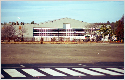
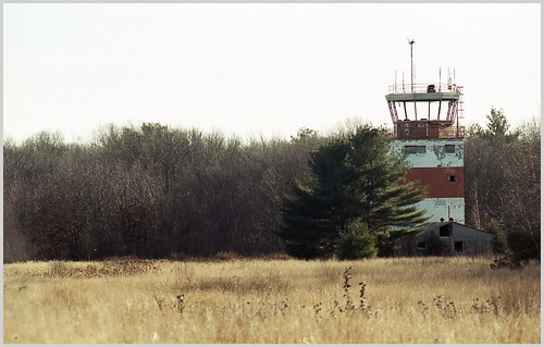
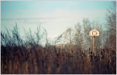
The Backside Gang is happy to welcome a new contributor: Derek Watt. Derek recently explored Massachusetts' Naval Air Station South Weymouth, which was in operation from 1942 until 1997, when it was decommissioned. All of his shots were taken with 35mm..

26 Dec 15 04

(At one point, I believe there were 2 (or more) hangars.)

26 Dec 15 02

(This air tower is one of two at the site -- the older one.)

26 Dec 15 01

(The basketball hoop is located next to the air tower, presumably for the service personnel to use for recreation?)

In July 2015, a developer announced plans to combine housing, restaurants, businesses, a sports complex and a movie studio (in the hangar) on part of the old base, which spans the towns of Abington, Rockland and Weymouth.

Thursday, January 14, 2016

Traffic Stop

From Mick Melvin:

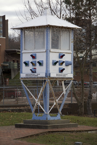
I was traveling to see my cousin in Meriden, CT, recently and made a wrong turn while heading to her house. I made an awesome discovery because of my lack of direction. The funny thing is, I came across an old traffic light on my journey. In downtown Meriden, there is a Traffic Control Tower dating back to 1925.

Untitled

The tower was patrolled by police officers who controlled the traffic from on high. I have never seen anything like it in my 50 years. The tower was quite innovative at the time, but it was removed after several years of contention.

The new rotary traffic system, which moved traffic along at a quicker pace, replaced the tower in 1967. The tower was moved to Giuffrida Park for many years and fell into disrepair. It was refurbished and moved to its current location in 1993. It now sits on the south side of the intersection of Colony St. and Hanover St.

For a related story with more facts and old pics of the tower with police officers in photo, click this link.

Scrambling Through Boston's Egleston Square

From Dave Brigham: I've danced around Boston's Egleston Square quite a bit over the years I've been publishing this blog. I...