Wednesday, May 6, 2015

Roam If You Want To

From Dave Brigham:

Often times when I set out with my camera to take pictures for this blog, I have a destination in mind. I've made note of an aqueduct head house, a named building, an abandoned factory or a stretch of long-forgotten railroad tracks and circled back to document the place in advance of doing research.

Almost as frequently, I'm going somewhere -- my accountant's office, Target, dropping my son at an appointment -- and remember to bring along my camera bag, in case I have time to poke around looking for my favorite places on the fringe. While I love exploring with a purpose in mind, it's these wild goose chases that raise my excitement level to that of a little kid under the tree on Christmas day.

Sometimes I get a lump of coal in my Backside stocking. Other times I drive around, pass a few promising places but continue on hoping for the equivalent of a new bike or a Red Ryder BB Gun (look it up....), only to run out of time. On enough occasions, however, I stumble across some cool places to take some interesting photos. Not everything has a story that I need to research. I just like hiking around, exploring and finding the less-traveled spots.

Here are some of the results.

As part of my ongoing mission to document the Backside of my adopted hometown, Newton, Mass., I've come across places that don't easily give themselves away. I suppose a knock on the door might lead to an answer, but I'm not usually willing to do that.

This fancy, rounded bench looks like it's made of cement. The letters "PD" are inscribed on the lower left section. I spotted this seat as I was trying to figure out where the one-time Stanley Steamer plant on the Newton-Watertown line once stood. The bench is in the corner of the yard of a rundown house situated in the most northeastern point of Newton.

Does the "PD" stand for Police Department? Was this bench originally sited in front of a local constabulary? Or are the initials attached to a person? Lots of questions about this oddly located, uncomfortable seat.

Built in 1900, this two-family house is, like the property in the previous photo, located in Newton Corner. I like the look of this place, which was recently rehabbed. Stalking the house on Google Maps, I noticed while on "street view" that there was a historic marker of some sort on the house. When I arrived with my camera a day or two later, however, I noticed that the marker was gone. Again, I could knock on the door and ask about the house and any historic significance, but I'm not very comfortable prying into people's lives that way.

Recently, I was on the other side of town, the southwest section of Newton called Oak Hill. I'd picked up my tax return in nearby Dedham, and had some time to kill before picking my son up at school. It was cold and overcast, with light hail falling as I walked into the woods just over the border in Boston's West Roxbury neighborhood. The trees provided decent cover from the precipitation as I walked a trail along the fringe of a cemetery and the remains of the Brook Farm. Across a thin stretch of trees I could see the Baker Street Jewish Cemeteries, 42 individual cemeteries run by the Jewish Cemetery Association. The path took me right past the far southwest corner, where I easily scrambled over a low wall and took this picture.

I continued on the path to the outskirts of Millennium Park in West Roxbury.

This is obviously a major teen hangout. There are dirt bike trails winding through the trees, and the odd beer bottle and piece of trash here and there.

I'm drawn to places like this because I grew up in places like this. Sure, I get excited by checking out urban decay and dream about undertaking actual urban exploration, instead of just snapping pictures of the outside of dilapidated buildings. But as a kid I explored the woods and streams and railroad tracks near my home. Some people look at these environments and don't see much, but there's always more there than meets the eye.

OK, twisted vines and a dried out ear of corn aren't typically what I feature here. But these are the types of things other people overlook on their way past little patches of woods and tiny fields that don't look like much. I took these shots in Concord, right near a place called Brigham Farm, which has been operated by distant relatives of mine (whom I've never met) since 1824.

In nearby Sudbury, I stopped to take pictures of a long-abandoned place that I'd seen (and taken pictures of) a few years ago.

Known as Bowker's Store, this place in the northern section of town was among a few spots that sold all manner of goods, and served as gas stations and local post offices, too, according to the Sudbury Chamber of Commerce.

According to Geocaching.com, Mr. Bowker passed away in 1965 and a man named George Sharkey took over ownership of the store. Shortly thereafter, the store applied for (and was denied) a liquor permit. It appears to have gone out of business soon after, according to the Geocashing site.

Founded in 1639, Sudbury was the third inland, Colonial town established in the Massachusetts Bay Colony, according to the town web site. As such, the settlement has quite a lot of history related to Native Americans, the Revolutionary War and even slavery.

I've never seen a street sign like this. It's pretty cool.

Friday, May 1, 2015

Odd-Church-Dive-Barn

From Dave Brigham:

Dedham, Massachusetts, has an illustrious history.

From Wikipedia:

The history of Dedham, Massachusetts began with the first settlers' arrival in 1635. The Puritans who built the village on what the Indians called Tiot incorporated the plantation in 1636. They devised a form of government in which almost every freeman could participate and eventually chose selectmen to run the affairs of the town. They then formed a church and nearly every family had at least one member.

The early residents of town built the first American canal, the first tax-supported public school, run by Ralph Wheelock, and Jonathan Fairbanks built what is today the oldest wood frame house in North America."

The town center is beautiful, with historic homes aplenty and great commercial buildings and wonderful churches.

(First Church and Parish, Dedham)

There's a cool social club. Well, used to be.

(Odd Fellows Hall, Dedham. Appears to be empty.)

But you read this blog, you know what I'm looking for. I hunt around the edges. I look for stuff that other people pass by. The forgotten spaces.

(The Oasis, Dedham. Now closed.)

Shuttered last year, The Oasis was a dive bar that reportedly opened in 1972. I thought it was a private club, but I wouldn't have gone there even if I'd known it was a public joint. A sushi place is slated to open there, according to reports online.

My standard line about dive bars is that I picture a bunch of old guys in sleeveless t-shirts and women with beehive hairdos eating pickled eggs out of a jar on the bar top. I'm sure The Oasis fit that image to some degree, but after posting that impression about a one-time dive in Waltham, Mass., a few years back, some of the former patrons commented that The Reef was all about community and friendship (see August 25, 2011, "Goodbye Reef, So Long Bill"). Make sure you scroll down and read the comments.

The final shot I made was right on the border of Dedham and West Roxbury, a neighborhood of Boston that still maintains a lot of its "lace curtain Irish" feel. But along the commercial strip of Route 1, just past the Boston Trailer Park, West Roxbury looks like Anytown, USA, with its fast food joints, car dealerships, mattress stores and empty storefronts.

There's one empty lot, between a Pets Supplies Plus and Prime Toyota Boston. An abandoned McDonald's, which stood across the parkway from an operating Mickey D's, was torched two years ago on this spot. Currently, there is a proposal before Boston authorities to build on this site a kosher hotel, which I admit is something I've never heard of.

Here's what's left on the lot.

Not sure what to make of this old shed. The building is close to the parking lot for the former McDonald's, but also sits on the fringe of significant green space along the Charles River. I'm guessing it was once part of a small farm. I'll keep an eye on this....

For more posts about Dedham, click these words.

Thursday, April 23, 2015

Named Buildings of Newton

From Dave Brigham:

I defy you to find a town or city in these United States that doesn't have a building with a permanent name on it, or historical records showing that there used to be such a thing. Back when architects, builders and businesses believed in permanence, they carved names into stone, presuming that, like Stonehenge, these edifices would stand for eons. Speaking of hewing things into the living rock....


Spinal tap - Stonehenge by samithemenace

Anyway, as regular Backside readers know, I've been on an on-and-off quest to document named buildings in Greater Boston. I could pursue this forever, and perhaps I shall. As for now, I'm highlighting a few buildings in Newton, where I live. Backside fans can expect a greater focus on Newton in the coming months. I plan to feature each of the city's 13 villages -- information about their history, links to old photos and of course my photos of what I found scurrying around the edges.

For now, here are some of the named buildings of Newton:

(Newtonville's Orr Building, longtime home of Armenian/Middle Eastern restaurant Karoun. Go for the food, stay for the belly dancing. I have no idea who or what this building is named after, but I plan to find out what I can as I work on the Newtonville component of my above-stated project.)

(The side entrance to the imposing Masonic Temple in Newtonville. Home to the Dalhousie Lodge, the building was erected in 1896.)

(Former Claflin Grammar School in Newtonville, now apartments. Built in 1891.)

(Stevens Building, Newton Highlands. Built in 1888.)

See the four previous parts of my ongoing Named Buildings series: #1, #2, #3 and #4.

Wednesday, April 15, 2015

From Motel to Mall

From Dave Brigham:

After a few days hanging out in garish Panama City Beach (see March 17, 2015, "Take Me Down to Panama City"), I was ready for something a little more down to Earth. In pamphlets about things to do in the area, I saw mention of "historic St. Andrew's" in Panama City, which is a separate town from the beach community that has been in the news lately for some awful goings-on during spring break. We ate lunch at a great place in the St. Andrew's neighborhood called the Shrimp Boat and then drove around a bit before heading back to our hotel.

I took note of lots of places I wanted to take pictures of, and made a plan to return early the next morning. The one building of interest to Backside of America readers is the old Cabana Motel.

On this web site you can see what the motel looked like when it opened in 1960. The facility closed many years ago, but in 2008 there was a plan to develop the site into the Cabana Hotel, which would have transformed the motel into a sleek, chrome-trimmed destination (scroll down on the above web site). I'm assuming that the economic downturn put the kibosh on that plan.

Here's what the Cabana looks like now:

When I saw its condition and the sign advertising the Cabana Courtyard Mall, I thought, "There goes another cool old motel." But I was wrong. The owner of the Shrimp Boat is saving part of the old motel as part of a plan to convert the building to retail shops.

Here's a local news report (sorry, the embed feature on this didn't work).

I hope the redevelopment works out for this cool little section of Panama City, which also features some funky shops and restaurants, a strip club (Tan Fannies) and a museum dedicated to the area's publishing history.

Tuesday, April 7, 2015

Signs of Old Times

From Dave Brigham:

I've wanted to take this photo for a long time. I know, I know. Not much to look at. But I suspect there's significant history behind this simple sign.

I pass this apartment house at 117-123 High Street in Waltham, Mass., on a regular basis. After numerous trips, I spied this sign, but didn't think about it too much. Repetition pounded my head and eventually I thought, "What the heck is with that sign?"

Through online searches, I've learned that the building dates to 1900, and has 20 rooms. High Street connects one of Waltham's primary commercial thoroughfares, Moody Street, with neighboring West Newton. As such, it represented a vital route for the Waltham & Newton Street Railway service, which launched in the late 19th century.

This apartment house is located on the corner of High and Newton streets. I'm guessing this sign marked this building as the Newton Street stop for street railway passengers. But what was the building in 1900? Was it a hotel? A train station? I'll keep digging.

Meanwhile, more recently I spied two other signs in Newton that are railroad-related.

This wonderful old house features a "NEWTON CENTRE" sign that I presume came from the nearby Green Line trolley station of that name. There is a cool station building there (now housing the Deluxe Station Diner) that dates to 1890, the days of the Boston & Albany Railroad.

This sign is also on a great old house in Newton Centre. The Green Line trolley runs directly behind this house, which sits between the Newton Centre and Newton Highlands stations. The Grand Trunk Railway was headquartered in Montreal, but included subsidiaries operating in most of New England. The residents must be pretty big train geeks.

The Grand Trunk has come up twice before here on the Backside:

October 13, 2014, "Portlandia," in which I posted a picture of a former Grand Trunk headquarters in Portland, Maine.

June 20, 2010, "The Truth Behind Beautiful Ruins," in which Joe Viger mentioned that his father worked for Berlin (NH) Mills Railway, which connected paper mills to outside carriers including Grand Trunk.

Friday, March 27, 2015

Blessed Renovation

From Dave Brigham:

I'm not a religious man, but I do love a nice church.

This beautiful building is the former Blessed Sacrament Church in Boston's Jamaica Plain neighborhood. I was in the area recently donating some supplies to the pet adoption center where we got our cat. I brought my camera with me, and before I even left the adoption center's parking lot, I spied the big green dome and knew I had to head in its direction.

Built between 1910 and 1913 and opened in 1917 by the Boston Catholic Archdiocese, the church closed in 2004. The massive church (approximately 1/2 acre in size) was the centerpiece of a campus that included a rectory, a convent and two schools.

Built in 1901, the Cheverus School (named after the first bishop of Boston) was closed for some time before the Hyde Square Task Force bought it and reopened the building as its Youth Community Development Center.

St. Norbert's School was built in 1926. The building was recently converted to 21 market-rate condos.

When I walked by the church, and saw boarded up windows where magnificent stained glass once resided, I was concerned that the building was being left to rot. Many of the old windows were removed to the Sacred Heart Church in Weymouth, Mass., but the church sat there like the proverbial 800-pound gorilla.

I was so happy to learn through my research that the building and its satellites are being repurposed.

The Hyde Square Task Force completed its purchase of Blessed Sacrament a little more than a year ago. They have big plans.

From the HSTF web site:

The Church will be a place where people from all races and ethnicities and from all walks of life from Hyde/Jackson Square, Jamaica Plain, and beyond will gather, perform, create community, and celebrate individual, family, and community wide events. It will also be a place that showcases the cultural richness of the Latin Quarter through arts and cultural events.

For a history of the task force's involvement with the church and its affiliated buildings, read this piece.

For a look inside the church on the cusp of the renovations, check this link.

To see historical photos of the church campus and surrounding area, check this out.

Tuesday, March 17, 2015

Take Me Down to Panama City

From Dave Brigham:

I visited Panama City Beach, Florida, recently with my wife and kids to get away from the brutal winter we've been having in eastern Massachusetts. We stayed in a pretty nice resort hotel, and spent a lot of our time eating at chain restaurants and hanging out in nicely buffed museums like Ripley's Believe It or Not and WonderWorks. While we got a little bit of local flavor at a few eateries, I felt the need to venture off the resort-filled main drag and poke around the underbrush.

Waking up early on our second morning there, before everybody else, I realized this was my best time to explore. The previous day we'd driven by countless surf shops, drive-through liquor stores, mini golf courses, motels, restaurants and pawn shops. Any of those places would have made for some great photos, but instead I headed first for an abandoned structure that I honestly couldn't identify.

After cruising around the Abandoned Gulf Coast web site, I found some photos of the good old days of Panama City Beach. This led me to the Flickr account of one of the members of that site. This guy told me that this building used to be a bar. I tried to join a Panama City Beach-related Facebook page to post my photo and ask members for more details, but my request has to be processed. If I find out more, I'll update this post.

For more cool photos of the entertainment heyday of Panama City Beach, check out the Parks and More and Buildings sections of the Abandoned Gulf Coast site.

While at first my eye was drawn to the mammoth beachside hotels and condominium complexes, I soon realized that there were a LOT of empty concrete slabs all over Panama City Beach, including this one two doors down from our hotel.

This, of course, led me to Google, where I learned that this town used to be a lot more honky tonk, with motels galore (the Fiesta, Inn Paradise, Trade Winds, Rip Tide, Barney Gray), locally owned restaurants and numerous theme parks (Miracle Strip Amusement Park, Jungle Land [which now houses Alvin's Island Magic Mountain Store], Goofy Golf, Castle Dracula, the Ocean Opry, Petticoat Junction, the Snake-a-Torium).

The Inn Paradise still stands, but has been stripped and will be torn down and replaced, according to what I've read online.

Here's a video looking back at the heyday of Miracle Strip Amusement Park:

Here's a video of the Sky Ride at Miracle Strip:

I found this remnant of the Sky Ride launch area while driving past Shipwreck Island Water Park:

I wish I could travel back in time to Panama City Beach during the 1950's and '60's, to see all the goofy, home-spun roadside attractions, enjoy unobstructed views of the beach and maybe catch a drive-in screening of "Gidget." And back to the time when this property was vibrant and filled with happy beach-goers, instead of fallow and overgrown.

I'd also like to travel back to the more recent future, to warn whoever planned this development, to let them know that it might be a bad idea to place a multi-story hotel or condo complex in a residential neighborhood. I assume the economic downturn in 2008 had something to do with this project being abandoned. Will somebody pick up the slack?

I spent approximately five hours spread across three early mornings pin-balling around town in my rental car, trying to find the forgotten side of a beach community that in this century has morphed from part of the Redneck Riviera to Spring Break Central.

I learned through my research online of Joe Breakbill, aka Flamingo Joe, who owned a a restaurant and market in Panama City Beach before passing away suddenly in 2013 at age 66. He opened Flaming Joe's Market just a few months before his death. The store was damaged during a storm not long after his death. At some point in the last 18 months the store was wiped off the face of the Earth.

Goodbye, PCB.

Monday, March 9, 2015

Chewed Up, Spit Out

From Kristen Smith:

It's good to welcome Kristen Smith back to the Backside! She's contributed some great stuff over the years (I've linked to some at the bottom of this post), and this post is no different. Amazing shots from Wyoming and Idaho. Enjoy! -- D.B.

As you drive into the Gros Ventre section of Grand Teton National Park you'll come across this abandoned homestead with a world-class view. I don't know who tried to ranch here or what he tried to raise, but Wyoming chewed him up and spit him out.

On our way into the Jedediah Smith National Forest in Idaho, I saw this abandoned cabin on a spur road. There were no trespassing signs up so I did what I could with it. I like the black empty sockets of the windows and so playing with the processing seemed to work well to show up the bleak quality of the scene.

Another semi-cliche shot of Grand Teton through the window of a derelict cabin in the Bridger-Teton national forest.

Here are some other posts of Kristen's:

Demolition -- Par for the Course

Nice Little House

Roadside Attractions?

Lost Bomber

Friday, February 27, 2015

Digesting Deer Island

From Dave Brigham:

As someone who didn't grow up near Boston, I associate Deer Island with its current use as a waste water treatment plant. Over the last few hundred years, however, the island has served many purposes, some ignominious, others more humane. I'm sure that before the Pilgrims landed in Massachusetts the native people used the island (which hasn't technically been an island since a hurricane in 1938 filled in a channel) for fishing and perhaps even hunting.

During King Philip's War in the 1670's, according to Wikipedia, the British interned as many as 1,000 Indians on the island, many of whom died. In the 1840's a hospital was established there to deal with the flood of Irish immigrants. In ensuing decades a poorhouse was built; by the end of the 19th century that facility was turned into a prison.

According to a report by Boston radio station WBUR, the remains of that prison, the Deer Island House of Correction, "are no more than a small wall dubbed the 'Great Wall of China' by local workers."

A few times in the last 20 years I've observed Deer Island from Boston Harbor (and other times from the air, coming into Logan Airport) and was struck by its massive, egg-shaped "digesters," which break down waste. I had no idea until recently that there are public walking trails on the island.

After spending some time spotting planes at a nearby beach in Winthrop with my son, Owen, I suggested we drive toward what I thought were giant sculptures I could see off to the south. Just a few minutes later we approached the area, and I realized what I was seeing were not sculptures, but a smokestack and a water tank on Deer Island (hey, I'm a writer, not an engineer).

We parked and walked around for a bit. I was surprised to see the remnants of a pier.

I was even more surprised to climb a steep, paved path and get a look at this:

Owen and I got our final surprise when we turned around and looked across the harbor.

I definitely plan to return to Deer Island and get more pictures.

Saturday, February 14, 2015

Crumpled Paper Company

From Heidi Waugaman-Page:

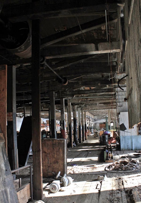
While on furlough in the summer of 2012 I landed a freelance design job for a small newspaper in Chester, Vermont. Every day I would drive by many factories, train stations and other buildings being consumed by nature and vandals in the run-down city of Bellows Falls. The town had obviously been a hub at one time with beautiful, large Victorians peeking through the trees. Today Bellow Falls has a drug and crime problem, so I didn't feel as brave as usual exploring by myself. So one weekend my husband and I took a drive up to start hitting some of the areas I had driven by while road exploring.

The Robertson Paper Company was my first stop. I explored around the building and took some outside shots before moving onto other buildings in the town. It looked pretty dangerous so I didn't attempt to go inside. There was a part of the building that looked like maybe homeless people were squatting in because there were some patio chairs out on part of the roof. So we decided to leave after that.

This part of the story ends here.

Bring it forward to fall 2014. My artist/photographer friend, Rick, and I had been talking about going on an adventure. I had been talking about getting back to Bellows Falls so he could check out all the great rust and decay of this worn-out city. We headed out on the coldest day and thought we would have enough time to hit many of the sites. Little did we know that we would spend the whole day just at the Robertson Paper Company Mill.

We arrived, parked and started exploring. Rick suggested that we get inside if possible. Then he noticed a woman looking out a window. We both figured it was homeless people in there. Then the door opened and a woman asked us not to park in front of the loading dock, due to deliveries. Rick and I looked at each other in disbelief that anyone would be delivering anything to an abandoned mill. I apologized and said we loved their building.

Her company was Robertson Printing Co. They had slowly lost more and more printing jobs overseas. They were only printing tissue paper for specific brands through the holidays. The town bought their property and because it was too expensive to move their equipment, so they were walking away.

I have learned to take chances, so I asked if there would be any way that we could come in to take pictures. The woman welcomed us to come in and explore but first gave us a stern WARNING: "Be careful, because the place is collapsing, and if you get hurt, you broke in and we don't know you." We were so thankful and giddy with excitement. She asked us to just check back in before we left so that they had a body count as to who was in the building and who left.

This is just a small taste of all the great finds we discovered. Enjoy.

Saturday, February 7, 2015

The Price of Gas

From Dave Brigham:

The smokestack in the background tells you that you're in an industrial area. Well, you would've been if you were standing here 100 years ago. The brick buildings that once stood on this site in Waltham, Mass., were torn down years ago, replaced by a restaurant, movie theater, parking garage and public housing. The smokestack is on the former Francis Cabot Lowell Mill, one of America's first textile mills. The mill is now home to senior housing, the Charles River Museum of Industry and Innovation and a public Internet center.

The area in this photo between the fence and the tree line -- that's what grabs my interest. While all else around the site has been developed, this place remains vacant, because it will require some major clean-up.

This is Cooper Street, a short, dog-legged piece of road that runs off Pine Street and behind Ristorante Marcellino. This is where the Waltham Gas Light Company once stood. According to Wikipedia, this area was "one of the oldest industrial complexes on the south side of the city, with brick buildings dating to 1854-55, not long after the founding of" the gas company.

In 1902, the gas company acquired the old Parmenter Crayon Company building, according to the Waltham Museum web site. Waltham Gas at that point became owner of the entire Cooper Street area west of the Watertown railroad tracks.

Just seven years later, according to the museum web site, Waltham Gas shut down, "transferring its electrical business to Boston Edison, which still operates an electrical substation in a nearby former company building. The other company buildings were converted to other manufacturing uses, and were demolished in 2007."

I've been unable to find out who owns the vacant lot, but I did locate information about the site, a place that I've wondered about for years as I've walked by or parked in the nearby lot for a movie or for dinner.

According to a Bentley University research paper about the nearby Moody Street commercial sector, the City of Waltham doesn't own the property, which "is believed to be the site of heavy waste contamination." The report states that a chemical has been placed on the property to prevent contaminants from spreading to the nearby Charles River. The Bentley team estimated in its report six years ago that scrubbing the site might cost between $1 million and $3 million.

The city and the property owner have apparently been fighting about who should pay for the cleanup. The city evidently would like to use the site as additional parking for the busy Moody Street shopping and dining district.

In the meantime, the Massachusetts Department of Conservation and Recreation is doing its part to beautify the area. Directly across the river from this site, in the shadow of that smokestack, the DCR is connecting an existing part of the Charles River Greenway on Elm Street by building a boardwalk under a bridge and connecting it to a new path where until recently there were abandoned train tracks leading to a trestle.

Here's what the site looked like shortly after the DCR started:

I know I have a shot of the old trestle that used to hang over this site as it crossed the river between the Francis Cabot Lowell mill building and a car wash, stopping just short of the Cooper Street site in question. But I can't find it. I did dig up a shot I took of the trash that used to fill the site where the DCR is now building the boardwalk.

Observant Backside fans will recall I posted this shot in January 2011. Who tosses a perfectly good acoustic guitar down a hill?

So, with the state beautifying the area just across the river from the Cooper Street property and tearing down the old trestle (which I suppose some saw as an eyesore; I thought it gave a nice patina to the area), I imagine there will be pressure to settle the differences over the cleanup and move forward to put the old Waltham Gas site to some sort of use.

Here's a Google Maps view of the property (first time here on the Backside that I've tried this).

The site in question sits directly behind (or above, in this map) the building marked Ristorante Marcellino. Just under the white box in the upper left corner that I wish I could get rid of, there is the outline of what I believe was a rather large gas tank.

I understand the City of Waltham would like to use this area to expand parking, but it would be nice if it were used as pure green space.

Checking Out Dudley Street in Roxbury...and a Historic, Pre-Civil War House

From Dave Brigham: As part of a series of quick-hit jaunts through Boston this spring, I checked out the outer reaches of Nubian Square, m...