I miss the tiring walks I used to take while on subway trips into Boston with my son. Truly, I do. We haven't ridden the train since early March, and I have no idea when we'll get back out there. Anyway, today's post is the fruit of an approximately three-mile trek that started at South Boston's Broadway station, meandered over Amtrak and Red Line subway tracks into the South End, and then briefly along Albany Street, over to Washington Street into the northern fringe of Roxbury, and ended at Symphony Station on the Green Line. I will post other photos from this journey separately.
There are so many areas of Boston I've never explored, mostly ones that aren't close to subway stations. I would've loved to push beyond the Grant A.M.E. Church on Washington Street and into Dudley Square, but I didn't have time. I suppose once Owen is in college and isn't interested in doing these trips with me, I'll drive to places and explore more.
There was music pumping out of the church as I walked by. It sounded fantastic. Formed in 1919, the congregation worshiped in several sites before this one, including other locations in Roxbury, and one in the South End. Grant A.M.E. moved into this church in 1952. Built in 1892, this property is known historically as Church of the Ascension, per MACRIS.
The church suffered a fire in 1966. By 1972, the church had been restored and upgraded, per the congregation's history.
Two doors down, and directly across from Ramsay Park, which features the Jim Rice Baseball Field, is the former Sriberg Furniture building.
Built in 1916, this four-story building is being renovated (including the addition of two floors) for apartments, including 13% (4 units) of them affordable, per this Boston Planning & Development Agency document.
The furniture store opened in the early 1900s, built this place in 1946 and closed in 1985, per Acadia Publishing's Boston's Orange Line, which I found at Google Books. In the '90s, antique architectural elements retailer Restoration Resources operated there.
I'm always happy to stumble across a restoration project rather than a demolition project.
Welcome to the second installment of my three-part series on Boston's Charlestown neighborhood. The first post has the relevant history in the first few paragraphs, along with, in my opinion, some nice photos of cool things (see April 25, 2020, "Charlestown Jaunt, Part I").
For this post, I'm going to start at the western edge, where Charlestown bumps up against Somerville at Sullivan Square.
"Sullivan Square stands on what was once a narrow neck of land referred to as the Charlestown Neck, an area that was originally a thin strip of land connecting the Charlestown Peninsula with present-day East Somerville," per Wikipedia. "Being in a narrow place between larger land masses made Sullivan Square a place where transportation routes naturally converged, and various transportation facilities developed here over the years." There is a station on the MBTA's Orange Line located here, underneath the elevated Interstate 93.
Dominating the Sullivan Square skyline is the Schrafft Center.
Built in 1928 for Schrafft's, the candy, chocolate and cake manufacturer founded in Sullivan Square in 1861 by William Schrafft, this building is now home to numerous businesses, including the Flatley Discovery Lab, FitCorp and RW Sullivan Engineering. Schrafft's eventually expanded to include restaurants, once the company had been taken over by Frank Shattuck. In 1967, Pet, Inc., a pioneer in evaporated milk, acquired Schrafft's. The various businesses were split off into separate companies. I'm not sure if anything survives under that brand today.
"In 2019, James Byrne, a godson of the Shattucks, the founding family of Schrafft's Restaurants, announced the return of the brand with plans to open brick-and-mortar retail in the near term," per Wikipedia. He has launched a pretty good looking web site.
To see some cool interior photos of the Schrafft Center, check out this web site.
Across Main Street from the old candy factory is the headquarters for Teamsters Local 25, below.
Built in the 1890s for liquor retailer John Cauley, it is known as Cauley Hall, per MACRIS. It was built "in anticipation of elevated railway-related patronage," per MACRIS. That patronage came not long after the building's construction, in the form of Sullivan station. The building was located near Van Nostrand Brewery, per MACRIS. Was that beer operation run by this guy?
Across very busy Rutherford Avenue, within close proximity of the MBTA station, is the tidy red industrial building below.
This place is home to Farina Corporation, an HVAC firm founded in 1958. It is located on Spice Street -- named, I believe, for Stickney & Poor, the oldest spice milling company in the United States, which was located on the corner of this street and Cambridge Street, directly across from where Sullivan Square station is now. I'm not sure if the company survives today.
As for Farina's building, it dates to the late 19th century; its historic name is the Henry E. Wright and Son Milk Can Factory, per MACRIS.
I believe that the low-slung brick building next to Farina's shop was part of the milk can factory as well. Now home to construction company Pomeroy & Co., Inc., digital ad agency Maark and other businesses, this property was once home to a, um, I'm not sure. Maybe an electronics repair company...
The ghost sign above is on the back of the old milk can factory. It might say television. There's a sign on the front as well, which definitely says "SALES SERVICE."
Also close to the Schrafft Center, along Bunker Hill Street (near the community garden I profiled in the first post), is a former fire station.
Now home to the Charlestown Working Theater, this building rose in 1884 and was used as a firehouse until 1970.
Just up Bunker Hill Street is the former Charlestown Armory.
Built in 1907 (most likely), the armory went up for, per MACRIS, three Charlestown militia companies with room to accommodate a fourth: the Charlestown Cadets (Company A of the fifth regiment, est. 1858), the Charlestown City Guard (Company H the fifth regiment, est. 1850), and the Charlestown Artillery (Company A of the eighth regiment, est. 1775). In more recent years, the Boston Public Library used it for book storage, according to MACRIS. It is now -- say it with me -- condos.
(Cool door on the old armory.)
Let's look at some other municipal buildings, both current and former, starting with the firehouse below.
Located on Winthrop Street, near the former Winthrop Square Training Field, this recently restored property has some mysteries attached to it. Oh, nothing exciting like murders or ghosts. Just dates and addresses. As often happens when I research old places, I came across three sources, each with a different "built on" date for this place, which has been home to Engine 50 for more than 100 years.
The City of Boston assessing department lists the address as 34-A Winthrop Street, and its year built as 1899. MACRIS lists it as 32-A Winthrop, built in 1915. And a recent Boston Globearticle about its renovation has it at 34 Winthrop, built prior to 1853, which is the date it became a firehouse. So who the hell knows how old it is...
Across from the Bunker Hill Monument is the former Charlestown branch of the Boston Public Library.
Sorry for the sun-splashed photo. The building, which is now the Bunker Hill Museum, dates to 1912.
There are some wonderful homes in Monument Square. Below are homes along Tremont Street.
Between Tremont Street and Bunker Hill Street to the north, along a tiny street, I found my favorite Charlestown houses.
These took my breath away when I spied them around the corner as I walked up narrow Nearen Row.
Of course, there are tons of other amazing homes in Charlestown, such as the rowhouses below.
And great details like cobblestone streets....
...and whatever type of window is featured below.
Now time for some random shots, many of them from along Main Street. Below is one of the grander entrances I saw on my journey.
Next door to the studio is Mister Q. Cafe, which opened in the former Boston Juicing spot earlier this year.
Also along Main Street I found the interesting dichotomy below.
In the foreground is the former Bunker Hill Relics antique store. I'm not sure how long it was open or when it closed. On the right is Junebug, a flower and gift shop that's been open for, well, I have no idea how long.
Back over on Bunker Hill Street the monument below is located in front of the Dougherty Playground/Clougherty Pool (Irish much?).
Placed in 1926 by the Bunker Hill Chapter of the Daughters of the American Revolution, the plaque says, "CHARLESTOWN HEIGHTS JUNE 17, 1775." That's the date of the Battle of Bunker Hill.
Below is 356-358 Main Street.
I haven't found much about this building, other than the usual confusion. The Boston Assessing department lists the year built as 1912. Well, as you can see if you enlarge the photo, this place went up in 1868. I don't understand this.
Back over in City Square, I saw this funky old bank teller window.
This is the former Charlestown Trust Co. building, which went up in 1915. Notice the trompe l'oiel mural running past the window.
I'm gonna finish this post with another bank, perhaps the most stunning building I saw on my trek through Charlestown.
The Charlestown Five Cents Savings Bank in Thompson Square opened in 1876. "The Boston firm Moffette and Tolman designed this rare local example of High Victorian Gothic early in their practice," per this Society of Architectural Historians web page. "Complicated massing and the varied colors and textures of different building materials distinguish this example."
"Charlestown Savings Bank was founded in 1854 by a group of prominent local businessmen and civic leaders. Their offices were originally in City Square," per this Patch article. The bank worked with the King Solomon's Lodge of the Masons to build this beautiful place. Initially the bank occupied the second floor, while the Masons maintained facilities on the upper three floors. There were shops on the first floor, per the article. There is currently a Starbucks on the ground floor, alongside a Cambridge Savings Bank branch. I'm not sure what is on the upper floors.
I really dig the clock, below.
That's it for Part II. In the final installment, I will discuss and show photos of, among other things, social clubs, abandoned railroad tracks, graffiti and murals, a ghost sign, an old mill and some abandoned stuff near the recently opened Encore Boston Harbor casino just over the border in Everett.
Even after being almost completely demolished, the Boston Common Hotel in Back Bay looks pretty nice, don'tcha think?
Located nowhere near the Boston Common, the hotel was built in 1925 as part of the University Club, which is located next door. At some point, the building was the John Hancock Hotel and Conference Center. So why was it torn down? You know why.
"The Noannet Group, Saunders Hotel Group, and Cain International plan to open the $400 million project in early 2022. It will be the first mixed-use Raffles property in North America, and it’s due to include six dining-slash-drinking venues as well as expansion space for the adjacent University Club," per this Curbed Boston article.
Raffles Hotels & Resorts is a global chain that traces its roots to Singapore and a hotel opened there in 1887, per Wikipedia. The company operates 11 hotels. Also, in my opinion, the company sounds like the name of a clown or small dog.
This is first installment in a three-part series about Boston's Charlestown neighborhood. I will cover all the usual stuff -- monuments, statues, churches, old school buildings, gardens. Everything I photographed, researched and wrote about in these posts is in the parts of Charlestown that are easily reachable by subway. As regular readers know, I regularly take T trips with my son, so the areas of the Hub I explore are all at least somewhat close to stops on the Blue, Red, Green and Orange lines. I hope you enjoy taking this adventure with me!
Separated from the North End by the Charles River/Boston Harbor, Charlestown is Boston's oldest neighborhood. "Charlestown was laid out in 1629 by engineer Thomas Graves, one of its earliest settlers, in the reign of Charles I of England," per Wikipedia. "It was originally a separate town and the first capital of the Massachusetts Bay Colony." When I moved to Boston in 1990, the neighborhood was nearing the end of its run as an Irish Mafia enclave. "In the late 1980s...Charlestown underwent a massive Yuppie gentrification process similar to that of the South End," says Wikipedia. "Drawn to its proximity to downtown and its colonial, red-brick, row-house housing stock, similar to that of Beacon Hill, many yuppie and upper-middle-class professionals moved to the neighborhood. In the late 1990s, additional gentrification took place, similar to that in neighboring Somerville. Today the neighborhood is a mix of yuppies, upper-middle-class and middle-class residents, housing projects, and a large working-class Irish-American demographic and culture that is still predominant.
Not long after moving to Boston, my buddy Jim, who grew up in Somerville, drove me through South Boston. I recall a much rougher neighborhood than what this area is now. I saw at least one pro-IRA mural, which I found shocking, although I shouldn't have. I'm guessing Charlestown would have looked quite the same back then. Anyway, on to the results of my tour....
Standing 221 feet tall, the monument was built between 1825 and 1843, replacing a previous 18-foot wooden memorial. The obelisk, which commemorates the 1775 Battle of Bunker Hill during the Revolutionary War, actually stands on Breed's Hill, where most of the fighting took place in that early battle. Although I've lived in the Boston area for 30 years, I've never climbed the monument. The one time I visited with my kids, the place was closed for construction.
(The Bunker Hill Monument dominates the south-central portion of Charlestown.)
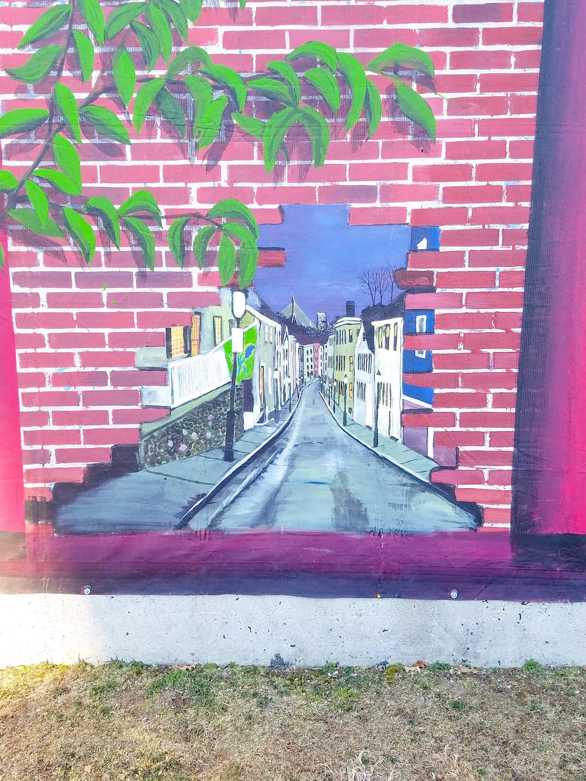
In Galvin Memorial Park along New Rutherford Avenue, hard by I-93, I found the two paintings below.
The top one depicts what I imagine is the Battle of Bunker Hill. The lower one portrays a lovely narrow street with quaint Colonial homes. I haven't found any information about who did these works of art.
Not far from Galvin Park is City Square Park. "Located on the spot of the founding of Charlestown in 1628, City Square Park occupies land where John Winthrop, the first governor of Massachusetts, built his home," per this American Society of Landscape Architects web site. "Kept as an open square for much of the early part of the nation’s history, several arterial roads converged on this space by the 1950s. In order to restore the open character of the space, beginning in the 1970s, the Central Artery North Area project moved all of the main roads into tunnels under the site."
The result is a lovely, tree-shaded park with benches, open space and historic plaques and memorials galore.
The flag pole in the middle of the park marks the site of the first Colonial settlement in Charlestown in 1629. "On this summit was built the Hill Fort with palisades and flankers," the flag base reads in part.
(This plaque is one of many in the area near the flag pole. This one also marks the site where the first settlement was laid out.)
The one below indicates that one of the first schoolhouses in the Massachusetts Bay Colony was built on this hill. Schools stood on this site for more than three centuries afterwards.
Below is a plaque showing the Arbella, the flagship of the Winthrop Fleet, upon which Gov. John Winthrop and others transported the the charter of the Massachusetts Bay Company from England to Salem.
Lastly, this plaque shows a likeness of a windmill built on the hill in 1635 to grind grains harvested nearby.
Also located in City Square is Charlestown Veterans Memorial Park, below.
It is dedicated to Korean and Vietnam war veterans, including, of course, "those who made the supreme sacrifice."
There are other, more lighthearted plaques in Charlestown. The one below for Samuel A.C.W. Donnell, for instance.
Located at the corner of Salem and Main streets, this marker says: "In honor of Samuel A C W Donnell, 1916-1982, He led the way to Charlestown's renewal by saving three houses at 81 Warren Street and 2, 4 and 8 Salem Street. Sam often gave advice to others in renovating the older houses he loved, often donating his own labor as well. Given by friends, June 7, 1985”. Zoom in and be impressed by his hat, beard and mustache!
Donnell worked to preserve extremely important features of Charlestown. The marker below honors a hometown boy made good.
Located on an outside wall of the Charlestown Boys & Girls Club, this plaque recognizes Charlestown as the "hometown" of NFL Hall of Famer Howie Long (the plaque was installed in 2011 by the Pro Football Hall of Fame and Allstate Insurance). Although Long was born in Somerville, he was raised in Charlestown, per Wikipedia. He played 13 seasons for the Raiders franchise, and was named an All-Pro eight times.
Let's move on to churches and holy statues.
Across the street from the Boys & Girls Club is the First Church in Charlestown.
The congregation was founded in 1632 (!); among its early ministers was John Harvard, who bequeathed money to a college that was eventually named in his honor. Perhaps you've heard of it. More importantly to my history, he also gave his name to a small East Coast chain of brew pubs.
Anyway, the church's meeting house was burned during the Battle of Bunker Hill. In 1911, the congregation merged with the Winthrop Church and moved into its current building on Green Street, per the church's web site. In 1957 a major fire destroyed the sanctuary and steeple. Members do most of the restoration and rebuilding work. During Boston's school busing crisis in the late '60s and into the '70s, the church became a sanctuary for black students who waited nearby for a bus. "Bricks and rocks are thrown into the windows of the sanctuary. The windows are still boarded up from the damage." Well, that answers the primary question I had about why the church looks the way it does. Jesus, who throws bricks and rocks through church windows?!
At the corner of Warren and Winthrop streets sits the St. Catherine of Siena Chapel. I took a picture of the front of the church, but it wasn't so great. So here are some details.
Officially, this parish is known as St. Mary-St. Catherine of Siena since a 2006 union of the churches in which they now use the St. Mary facilities. "In 1828, Bishop Joseph Fenwick established St. Mary’s, the very first Catholic parish in Boston. That is, it was the first parish to be established separate from the Cathedral of the Holy Cross," per the church's web site. St. Catherine was founded in 1895. In the rear of the church is a peace garden, below.
Across Winthrop Street is the former St. Mary's School, below. The building has been incorporated into the Constitution Co-op affordable apartment complex for seniors.
Below is the former St. Catherine of Siena School and Hall on Tufts Street. The building is now home to the NEW Health Center.
Below are two shots of an annex building behind the school, which I believe was used by the school. The entire property, including the church (which I will get to in a minute; you will be surprised at its current use....), sold for $1.4 million in 2013. Some in the Catholic community thought the archdiocese should have gotten more money for the sale.
As for the church....
It's a Dollar Tree discount store. Seriously. I couldn't believe my eyes when I walked by this place. I've seen churches turned into apartments/condos, private single-family residences and restaurants. But never a Dollar Tree. Since 2004, the Boston Archdiocese has shuttered dozens of churches, due largely to the priest sex abuse scandal, as well as declining membership. Other buildings have become condos, while some have been torn down in favor of hockey rinks and other buildings.
The final church on my tour -- and believe me, there are plenty of others I skipped -- is St. Francis de Sales Parish on Bunker Hill Street.
What a beauty! The building dates to 1862; the parish was founded three years prior. Born in France in 1567, Francis de Sales was a Bishop of Geneva and was sainted in 1665.
On the grounds of the church is a statue of Saint Florian, below. He is "the patron saint of Linz, Austria; chimney sweeps; soapmakers, and firefighters," per Wikipedia. "St. Florian is also the patron of Upper Austria, jointly with Saint Leopold."
Next door is the former convent associated with the church (below). Built in 1901 for the Dominican Sisters who staffed the St. Francis school, the building is now the church's parish hall, I believe.
Across from St. Francis de Sales is a statue of the Virgin Mary (I think), dedicated to the Irish patriots who fought and died at the Battle of Bunker Hill.
Used for burials since perhaps as early as 1801, the cemetery was originally intended for the use of the town's poor, but eventually it was opened up to other citizens, per the City of Boston web site.
I've covered former parochial schools, so how about some former public ones?
Located on Baldwin Street, the Bunker Hill School opened in 1866. It is now condos, natch.
The former B.F. Tweed School, below, is located in Sullivan Square, at the confluence of Rutherford Ave., Cambridge Street and Main Street.
I haven't found anything out about the school or the man it was named after. It is now home to a cycling studio and a fitness gym.
Speaking of things I can't dig up information on...
This is the James Brown House, circa 1855. I would love to report that this is where The Godfather of Soul was born, because, well, this:
But I don't know who circa-1855 James Brown was.
Funny that a house with a historic marker isn't searchable online, but the place below, which I randomly stumbled across, and which has no plaque upon it, has an entire article written about it.
Built in 1808, 23 Pleasant Street may have been the first house on the little roadway, per this Patch article. "The gambrel house...is, according to Boston Landmarks Commission, part of Charlestown's small collection of late Georgian gambrel houses," per the article. "Records show that members of the Kettell family, who lived in Charlestown from the birth of Joseph Kettell in 1641, were the original owners of the house. (John Kettell, a descendant, was a member of the Massachusetts House of Representatives between 1809 and 1812.)"
There are so many cool houses like this in Charlestown, Beacon Hill, the South End, Bay Village and other neighborhoods. I love when I take a random photo and it turns out that somebody else found it interesting enough to write a short news article about.
I love shooting details of all sorts, as you've no figured out. Below is a sign for Washington Street, placed right into the building.
The building is 34 Harvard Street, right across the park I mentioned above with the flag pole and all the historic markers. Built in 1880, this lovely brick structure is a one-family home assessed at just under $2.5 million.
I'm going to wrap up with the wonderful community garden at the intersection of Main and Bunker Hill streets.
Gardens for Charlestown was created in 1976 out of a "rubble-strewn lot owned by the Boston Redevelopment Authority," per the organization's web site. "The City's plan to construct a school on the site did not go forward, and the property began to attract unsavory uses. A handful of residents cleared enough land for a few vegetable plots, and the Garden was born."
It's a very peaceful spot.
(In the background in the photo above is a former fire station, which is now home to a community theater. I'll share photos and more information in a subsequent post.)
In the next post, I will cover some cool architectural details, a neat old clock, a former armory, some named buildings, the old firehouse near the community garden, and much more.