Monday, July 13, 2020

Gettin' Maverick-y

From Dave Brigham:

Located between Boston Inner Harbor, Route 1A and the Mystic River, the Maverick Square and Jeffries Point neighborhoods were the earliest areas of East Boston to be developed, back in the 1830s, per Wikipedia. In short order, the East Boston Company laid out a street grid and built a bridge connecting to Chelsea. During this time, the East Boston Lumber Company and the Boston Sugar Refinery were founded in the area, and several wharves were built.

Shipbuilding became a mainstay of the economy; in 1836, Boston annexed its eastern neighbor. This is a simplified history, but here you go: eventually railroads came, as did immigrants over the decades, from Ireland, Canada, Russia, Italy, Southeast Asia and, more recently, Central and South America. This is the kind of neighborhood I love to explore. And so I did. Here's what I found.

What better place to start than a mural about East Boston's history.

Located on the side of the Americano Espresso Bar along Meridian Street, facing the Walgreens parking lot, this giant mural is somewhat faded, but is a great work. Noteworthy people, sites and events include the Battle of Noddle's Island (the former Noddle's Island now consists of much of the southern end of East Boston; the battle was the second Boston campaign of the Revolutionary War); Wood Island, a former park, much of which was razed to expand Logan Airport; the first underwater tunnel in America, linking East Boston's trolleys to downtown Boston; the East Boston Shipyard; and Amelia Earhart, who took off from the then-East Boston Airport on her historic flight as the first woman to fly across the Atlantic. There also appear to be random folks who I'm guessing represent the neighborhood's history of welcoming immigrants.

Let's look at another wonderful work of public art.

When I shot this photo this past winter, I assumed this was part of the church you can see in the background (the Central Assembly of God), but I was wrong. This beautiful mural is on the side of the Consulate General of El Salvador. That Central American nation is one of the top 10 countries from which new immigrants to Boston hail.

Want more public art? You got it!

This work showing an astronaut floating in space while looking down at Earth is located in what's called Our Garden, a community project located between Border and Meridian streets near the East Boston Skate Park. Artist Gretchen Schneider worked with the Neighborhood of Affordable Housing to turn this park from an unsafe passageway to a brightly lit, welcoming space.

The painting below is on the same building.

This one is signed Enivo, which is the name of a Brazilian street artist. Not sure if it's his work or somebody biting his moves.

The next work of art is on the side of Mi Pueblito, a Mexican/Salvadoran/Guatemalan restaurant on Border Street.

The mural faces the Eagle Hill Community Garden, which is operated by a partnership between the Trustees of Reservations, the Boston Mayor's Office of New Urban Mechanics and TD Bank. The painting is of an East Boston wharf scene, with the Bunker Hill Monument in the background.

The next one is a little different. A street mural.

This art is on the street in front of a former candy and gum factory. Backing up to the East Boston Greenway (a former Conrail train line), at the corner of Orleans and Grove streets, the old factory rose in 1917 and was home to the Cox Confectionery Company for 15 years. In the 1930s, San-Man Chocolates took over the property, per my old friend MACRIS. In the 1940s, the brilliantly named Gum Products, Inc. took over until 1982. It is now condos, and known as the Gumball Factory.

Heading northeast on Orleans Street, I couldn't miss this ugly, hulking behemoth at the corner of Porter Street.

Built in 1911 and known as the Engel-Cone Shoe Company Building, this eyesore has caused neighborhood folks trouble for quite a few years. "Since 2016 residents living in the Gove Street area have compared the dilapidated building on the corner of Porter and Orleans streets to something you would see in wartorn regions rather than East Boston," is how this February 28, 2020, East Boston Times article begins.

The developers, referred to in the article only as "the Patels," bought the building in 2017 with intentions of turning it into a boutique hotel. Their representative told the newspaper that the Patels have made progress in negotiating with companies that own telecommunications antennas on the building's roof. "When dealing with the relocation of telecommunication antennas there [is a] very complicated and legal choreography that has to occur before you can move forward. Because moving them causes a disruption in service there a whole host of issues that come with that," attorney Richard Lynds said.

As of that February article, the developers said they were awaiting city approvals, and that they hoped scaffolding would rise soon so a contractor can begin prepping the building. I have no idea if that has happened.

Across the street from this possible future chic hotel is 156 Porter Lofts, located in a former bra factory.

Prior to housing the Goddess Bra Factory, 156 Porter was home to General Electric's Edison Lamp Works, per this article. The property rose in 1913 to manufacture tungsten filament lamps, and later was used to make miniature Christmas lights, per the article.

Along Cottage Street, heading toward Maverick Street, I spied the cool detail below on an apartment building.

I next headed southeast on Maverick Street and spied the neat building below.

This is a former facility for B.M. Jones & Company, which manufactured railroad equipment. This space is now home to an auto body shop.

(Cool little door on the former factory.)

I turned around and headed northwest on Maverick Street and came across a pre-redevelopment scene.

Maverick Street Market and Swish & Swash Laundromat have been closed for a while, as you can see by the fencing surrounding the property.

In July 2018, developer Joseph Nogueira proposed replacing these businesses with a five-story apartment building. He said the market and laundromat would be invited to reopen on the ground floor. I have no idea where this project stands.

At the intersection of Maverick and Orleans streets stands this eyesore, which I hope is under renovation.

There is storefront space on the ground floor, apartment space above. The public phone doesn't work.

Continuing southwest on Orleans Street, I saw the newer face of East Boston: nice apartment buildings, the Cunard Tavern, a yoga space. Naturally, as you head toward the waterfront, things get greener and pricier. Along the East Boston Greenway is the relic below.

This old Conrail caboose is evidently similar to one that was stationed nearby and which served as a kitchen for dock workers. The Greenway -- officially the Mary Ellen Welch Greenway (she was a teacher and activist who died in 2019) -- lies along a former railway right-of-way for the Grand Junction Railroad, as well as a route once used by the Boston, Revere Beach and Lynn Railroad, per Wikipedia.

Near the Maverick Street overpass for the greenway stands the former Saints + Angels giftware store.

On the corner of Maverick and Bremen streets stands the one-time City of Boston Overseers of the Public Welfare building.

This is the second one of these former welfare buildings I've seen in Boston (see February 15, 2020, "A Vital Shelter in Boston"). To quote that February post: "Boston's history of sheltering and aiding its citizens dates to at least 1772, when the legislature created the Overseers of the Poor in the Town of Boston.... In 1864, the agency's name was changed to Overseers of the Poor in the City of Boston. The name morphed again in 1921, to Overseers of the Public Welfare." This place is now home to several businesses, including La Tia Smoke Shop, Ayda Custom Tailoring, Penguin Caterers and Didi's Spa.

Along Meridian Street I found El Diamante Billares, a pool hall.

Nearby is the wonderful Iglesia La Luz del Mundo (The Light of the World), which is "a nontrinitarian Christian denomination with international headquarters in Guadalajara, Jalisco, Mexico," per Wikipedia.

Also along Meridian Street is the Brazilian Soccer House.

Are you getting the picture that East Boston is home to a lot of immigrants?

Here's more proof. This storefront church is located further north on Meridian Street, next to the previously mentioned Our Garden, home to the outer space mural.

Keeping the religious theme going....

I believe this is along either Border Street or Liverpool Street, near the Mystic River.

Also along Border Street is one of my favorite signs, which I photographed several years ago and then again more recently. The first time was a lucky stumble-across, the second pure chance that I found it again.

Wigglesworth Machinery was founded in 1928. The company is still in business, although no longer at this location, as far as I can tell. This building appears to be for lease or sale (or was back a few months ago).
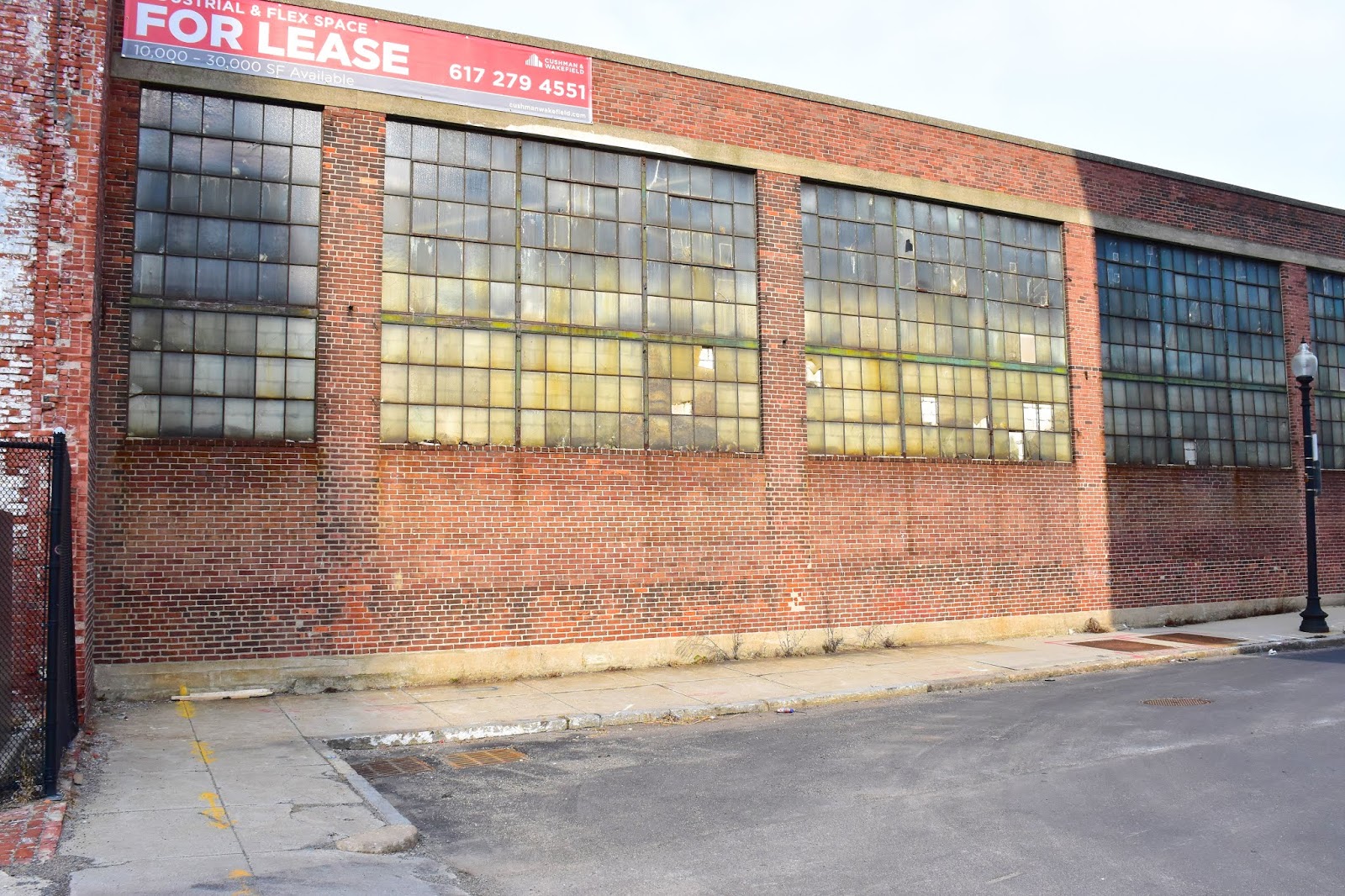
Just up the street is Atlantic Works Gallery, located in the former Atlantic Boiler Works building, which dates to 1901. The old Wigglesworth building is also a former boiler works property, per MACRIS.

I'm not sure if this sign is historic or new.

Also along Border Street is a cool sign that is one of my favorite ghosts that I've stumbled across, mainly because of the setting.

Located near Central Square, the former Mystic Shore Warehouse appears to have been vacant for quite some time. I love the combination of the faded sign, the bright graffiti and the yellow dumpster.

Across Central Square Park, along Meridian Street, I spied this named building.

Payless ShoeSource closed all its U.S. stores in 2019, so this sign may have come down by now. But the W.T. Grant Building sign is etched into stone, so it ain't going nowhere. "In 1906 the first 'W. T. Grant Co. 25 Cent Store' opened in Lynn, Massachusetts," per Wikipedia. "Modest profit, coupled with a fast turnover of inventory, caused the stores to grow to almost $100 million annual sales by 1936, the same year that William Thomas Grant started the W. T. Grant Foundation. By the time Grant died in 1972 at age 96, his chain of W. T. Grant Stores had grown to almost 1,200."

The chain stores were eventually known simply as Grants. There was one in my hometown when I was a kid.

Another business along Border Street, not far from the previously mentioned Mi Pueblito restaurant, is John Smith's Automotive & Sales.

"Let Me Work On Your Body."

Um, no thanks.

Also on Border Street I saw this old sign for a liquor store, hanging on a building that appears to have been recently converted to condos.

At the corner of Border and Lexington streets I had the view below.

I see this a lot around Boston - buildings standing alone, their former neighbors having been torn down around them. In this case, a low building abutting the purple wall has been razed, leaving an L-shaped space. I'm gathering something will go up here before too long, probably something with high price tags. This building was once an outpatient clinic.

Two doors down is the back door for Iglesias Senda de Fe ("Church Paths of Faith"), which I referenced above.

Last, and certainly not least, is an old-fashioned bowling alley.

Before my second trip through this area, I'd seen something about Central Park Lanes online and knew I had to seek it out. A candlepin facility, Central Park looks like it's been in business for quite a few decades.

For more of my adventures in East Boston, check out December 14, 2018, "Eastie Ramble" and November 3, 2018, "Pictures of Eastie Pride."

Tuesday, July 7, 2020

Union Square, Somerville, Part V: The Future?

From Dave Brigham:

A preface to this final installment in my five-part series: I can't imagine anybody cares, but I want to say that I had grand intentions at the outset of this series to get it done relatively quickly, and to present a fairly clear picture of the past, present and future of Union Square in Somerville, Mass. I feel like I've done a pretty good job with this first four posts to show most of the cool pieces of the neighborhood's past and present, and hinted at the future.

This last post was designed to analyze how the square will balance the needs and priorities of long-time residents and businesses, newer folks and shops, the state's transportation requirements and the desires of visitors to the area. I have lost my steam, my mojo and my train of thought on this series, and other people (the Boston Globe, in particular) have done, of course, a much better job covering this than I could ever hope to do. In addition, my explorations of Union Square took place more than 18 months ago, and some things have surely changed in the interim. Due to coronavirus restrictions, I have only made it back to the neighborhood once in recent months, and that was just to take a quick picture for the prior installment.

As much as I've researched Union Square and the changes that have already taken place and those that are coming, I realize that a few walks through the neighborhood and some poking around online can't match the breadth of knowledge earned by folks who live and work in Union Square. I'm just sharing what I saw and what I think. In this post I will do my best to speculate about where the square will be in five years, but don't hold me to it.

The biggest change coming to Somerville's Union Square will center on a new transit station as part of the MBTA's Green Line Extension program. The transit authority hopes to have the entire new series of stations open by the end of 2021.

Above is a shot I took in early 2019 of the site at the intersection of Prospect Street and Somerville Avenue (in foreground), where the new Green Line station will be housed, alongside multiple new buildings, including at least one apartment tower along with retail and lab/office space. The station will have one island serving the two tracks. Allen Street provides the eastern border of this new development.

Work to clean up the site began in September 2014, per this City of Somerville document. Contractors removed contaminated soil and demolished existing buildings. "From 1951 through 1989, the Kiley Barrel Company cleaned, refurbished and distributed drums containing both chemical and bakery products, and the Somerville Redevelopment Authority purchased the property in 2002," per the document.

All bets are pushed off in these COVID-19 days, but at some point the site in the photo above will be a bustling area filled with commuters, high-tech workers, well-to-do singles and families mixing in with long-time Union Square denizens, working-class folks and those taking advantage of fun new things to do in a neighborhood already known as an exciting nightlife destination. As an example of the existing dichotomy that will expand, I present the sign below.

As I wrote about in the first installment (links to previous posts are at the end of this one), Union Square has more than its share of auto body shops. Barnes & Walsh is located at the corner of Somerville Avenue and Merriam Street, and has been in business since 1929. The shop represents old Union Square. The other tenant on this sign, Bantam Cider Company, is located two doors down Merriam Street, and was founded elsewhere in the city in 2012. This brewery/taproom -- which fills space once occupied by White Rose Baking Company -- represents new Union Square.

More "new" businesses will join Bantam and other millennial-focused operations such as Urban Axes and Backbar, and they stand to benefit from easier public transit access. Of course, so much of that depends on a vaccine for the coronavirus.

Another site that shows the dichotomy between old and new Union Square is along Washington Street, just east of the Somerville Police Station.

On the right is Lucky Convenience, located in a building that dates to 1895. Across the street stands 197 Union Square, which features 30 one- and two-bedroom condos, a rooftop lounge and ground-floor retail/restaurants. This development was completed in 2016.

Cities are made of scenes like this, the mixing of old and new, immigrant and native-born, basic needs with extravagance, downtrodden with well-off. This is nothing new, especially in Somerville, which has seen similar meshing of old and new in Davis Square, and will likely see it to lesser degrees in smaller areas along the Green Line Extension, such as Magoun and Ball squares.

Let's look at some sites that I've pegged as possible new development properties.

J.J. Sullivan Plumbing & Heating has been in business since 1956. As far as I know, the company is solid. But the company's property seems, how to put this? Underused. Blighted. Not ready for prime time.

(Driveway and dilapidated garage at J.J. Sullivan.)

The best resource I found during my research into this series is the Union Square Neighborhood Plan. Adopted on May 5, 2016, by the Somerville Planning Board as an amendment to the city's master plan, the USNP lays out what the square will look like when the transit station is complete, open space is added, new developments are built and streetscapes are modified. The plan also makes recommendations for properties that may not currently be available for redevelopment. Such a site is 344-46 Somerville Avenue, home to J.J. Sullivan.

"This site has frontage onto two streets, Somerville Avenue to the north and Lake Street to the south, so the parcel should be split to create two separate lots with individual frontage on each street," the report states. "If redeveloped, the northern lot should be a 5-story general (mixed-use) building with residential over retail while the southern lot is more appropriate for an apartment building. The southern lot is suitable for family housing units because of its quiet residential street and close proximity to Argenziano School....This site is located within 1/2 mile of the future Union Square Station and should not have any residential minimum parking requirement because of its close proximity to transit."

Must be strange for property owners to read what city planners think should happen to their buildings and lots were they to sell. And let's face it, plenty will decide to cash in.

Perhaps a quarter mile from the site of the new transit station and other new buildings stands 201 Somerville Avenue, below.

Built in 1890 and home to commercial and residential space, this building has seen better days, both from a design standpoint, and a business outlook. Most recently it was home to the Somerville Bread Company, which opened in 2017 but was closed by the time I shot this photo in early 2019. I love the bread window, which allowed customers to conduct business from the sidewalk. There may be a travel agency named ItaliaDeals still located here, I'm not sure.

So what might become of this property? The USNP mentioned above doesn't cover this site, so I'm winging it here. Given that the property includes a walk-in freezer and a walk-in cooler, and has been used as a restaurant/bakery for quite some time (I'm guessing), I would assume somebody will buy it, gut the hell out of it and turn it into yet another cool restaurant to go along with other Union Square spots such as The Independent and Bronwyn.

OK, the final two locations are former auto-related businesses.

At 231 Washington Street, across from Ricky's Flower Market and adjacent to the former post office (now home to - new Union Square alert! - RightHand Robotics), is the former Union Gulf gas and service station.

"Thank you for 70 great years!" a sign on the building says. Right across Columbus Avenue is the former Monro Muffler Brake & Service, located directly across from Somerville Police Headquarters.

I haven't found anything in the USNP or elsewhere indicating what the plans might be for these sites. But each address is included in a late 2017 City of Somerville Planning Board document, along with several other addresses, as falling under the Union Square Coordinated Development Special Permit filed by Union Square Station Associates. The master plan for the square calls for at least 1.2 million square feet of lab and innovation space, as well as 1,000 new residences and 140,000 square feet of retail, restaurants and services. So take your pick on these two properties. I'm guessing a combination of retail/restaurant and gym space.

For the rest of the series, see:

May 29, 2020, "Union Square, Somerville, Part IV: Holy."

December 6, 2019, "Union Square, Somerville, Part III: Retail and Hangouts."

November 7, 2019, "Union Square, Somerville, Part II: Factories and Housing."

And August 25, 2019, "Union Square, Somerville, Part I: New Purposes & Grease Monkeys."

Tuesday, June 30, 2020

Chinatown Redux

From Dave Brigham:

As I was taking photos in Chinatown in February 2019, I knew that I would need to return, as there was just too much to capture in one afternoon. I researched and then wrote about that adventure last year (see July 31, 2019, "Won't You Take Me to...Chinatown?"). In October of last year, I made a second trip through this fascinating Boston neighborhood.

My usual method of writing posts is to present things in logical order by themes (i.e., ghost signs followed by cool architectural details followed by plaques, etc.). Today I want to showcase backside elements in the order that I came across them on my walk.

In the July 2019 post, I covered the heart of Chinatown, from Kneeland Street to John Fitzgerald Surface Road, Essex Street to Washington Street and a lot in between. For my most recent jaunt, I decided to hit the fringes a bit.

The first thing that caught my eye was 18 Pine Street, above, in the southwest quadrant of the neighborhood. Not far from the Mass. Pike and Harrison Avenue, this small street was the original location for the Pine Street Inn, the largest homeless services provider in New England. I have no idea what this sign says, or whether it's for a current business or one that's long gone. I believe this property is mostly, or perhaps all, apartments.

Right down the street, I spotted a different type of ghost sign than I usually see, one that made me feel like I was in an "Our Gang" short film.

"You can't post no bills here, see?" I can imagine some grizzled, middle-aged guy with a scally cap saying to a group of young toughs. "I catch you postin' bills here, I'll show you the back of my hand!"

"POST NO BILLS" signs are still used by building landlords to let people know they can't slap up posters, but this one, located on an out-of-the-way side street seems like its heyday has gone by.

Across from the tiny ghost sign, at the corner of Pine Street and Harrison Avenue, is the Boston Chinese Evangelical Church.

The congregation was founded in 1961; this building dates to 1979.

Heading north on Harrison Ave., I walked past a handful of produce vendors.

City Produce (not pictured, as it's not much to look at), Lun Fat Produce (foreground) and New England Food Supply (middle of the photo) are small operations that, I'm guessing, supply restaurants in Chinatown. Beyond New England Food Supply is May's Cake House (yellow awning) and a place called Top Ten, which I believe is a convenience store.

Next I scooted down Johnny Court, which is about a hundred yards from end to end, and saw this sign for Leung Association, which I think is a realty agency, and something called N.E.U.S.A.

All of the townhouses on this little street date to 1915, per this Bay State Banner article about gentrification on Johnny Court, and Chinatown in general.

My next stop was along Tyler Street, still in the southwest part of the neighborhood. I love all the rinky-dink (I mean this in a good way) stores and businesses in Chinatown, such as Chinamerica Food Manufacture, Inc.

Located between Long Wave Hair Salon and the New England Chang Sheng Association, Chinamerica has been in business since 1993. Just up the street on the other side is the Chinese Consolidated Benevolent Association of New England, outside of which I just had to snap a picture of the famous philosopher, Confucius.

Established in 1923, the CCBA of New England serves as an umbrella organization for roughly three dozen family associations and community organizations, per its web site. The group's building is the former Quincy Elementary School.

Over on Hudson Street, which is along the eastern border of Chinatown, next to an on-ramp for the Mass. Pike, I took a picture that captures the biggest issue in Chinatown: the potential of the new to overwhelm the old.

I took this photo from a nice slice of green space that sits between two relatively new buildings, 88 Hudson and One Greenway. The buildings in the foreground date, like many in Chinatown, to the late 19th/early 20th century. They are human-scaled, with TV antennas and interesting juxtapositions of doors, windows and rooflines. Looming in the background is Tufts University's Friedman School of Nutrition Science, which is one of many shiny new toys replacing historic structures and forcing lower-income, long-time residents out of their homes.

For those who are able to remain in the neighborhood, the Soo Yuen Benevolent Association of New England on Harvard Street, below, surely offers needed services.

From this quiet area, I cut up Tyler Street and out to the very busy Kneeland Street. There I found Ming Kee Live Poultry.

If you're able, I suggest enlarging this photo and looking at the window above the air conditioner. Should I offer you a clue, so you'll figure it out? Maybe I just did.

From this spot I wandered along Tyler Street to Beach Street -- the heart of Chinatown, much of which I'd shot on my previous trip -- heading toward the Chinatown Gate. Why didn't I shoot this landmark? Good question. Seemed too obvious a target, I guess. Walking across the plaza near the gate, I saw a fake "Wanted" poster on a shuttered former restaurant.

Dynasty Restaurant, which specialized in dim sum, opened here in the late 1980s or perhaps 1990. I'm not sure when it closed, as I couldn't find much about it on the Internet. Previous tenants in this building, which dates to 1914, include wholesale dry goods company Sparrow-Chisholm, diaper manufacturer Pinfree Manufacturing and the Pacific Kimono Company.

Steps away I shot the back of 129-131 Kingston Street, below, which dates to 1889 and was occupied over the first several decades of its life by curtain, dry goods and decorative novelty companies, among others. It is now home to architecture/design firm DumontJanks and a branch of German architecture firm Behnisch Architekten.

I got a bit artsy when shooting the buildings across the street from the "MORF" graffiti.

The yellow vertical sign in the middle is for Moon Villa, although the horizontal sign says "New Moon Villa." The restaurant has been in business since 1991.

Built in 1912, 17-19 Edinboro Street, like many other buildings in this area, was occupied for many decades by companies in the textile, shoe and and dry goods businesses, including those manufacturing and dealing in underwear, bathrobes and sportswear. Also, Ho Toy Noodle Company.

Next door is Wah Lum Kung-Fu Athletic Association, below.

On the front of the "MORF" building I found this little history lesson about industrial sprinklers.

I wasn't paying enough attention to why this little display is here. I think there were others of this type along the entire building.

Around the corner, on Essex Street, I spied this cool door detail.

This entryway is between the former Chau Chow City Dim Sum Restaurant and a one-time market, both of which I wrote about in my previous Chinatown post. Built in 1907 for a men's furnishing company, the Simons Hatch and Witten Co., the building has popped up in redevelopment discussions, but nothing seems to be solid at this point.

Around the corner on Chauncy Street once stood Winmil Fabrics.

The full-service fabric store closed in 2016 after 47 years in business. Built in 1902, this property is known as the Frost Brothers Building, after a pair of siblings who were real estate developers. Tenants over the years included Wachusett Shirt Co. and Bowditch & Clapp millinery goods. All of this information on these buildings comes, of course, from my good friend MACRIS.

One street over, on Harrison Avenue Extension, I spied this cool detail on the back of the massive Washington Essex Building.

Down Essex Street, between Hong Lok House and Dunkin' Donuts, is this former entrance to the Chinatown subway.

On Harrison Avenue is the fantastic mural below, which is a tribute to See Sun Market, which is closed but was open recently enough that it still shows up on Google Maps street view.

Across the street was this fantastic pop-up park.

A little ways down Harrison Avenue, heading toward Kneeland Street, is this bold advertisement for Connecticut's Mohegan Sun Casino.

Located on the side of the Bao Bao Bakery building, the ad has been there for years, I believe. Or at least some variation of Mohegan Sun advertising has.

Accessible via the parking lot next to the bakery is the amazing mural below.

Located on the side of the China Gourmet restaurant on Tyler Street, "Tale of an Ancient Vase" was painted by Bryan Beyung, an artist based in Montreal whose work has been displayed in Vietnam, Haiti, Canada and Cambodia, per this Sampan article. Beyung's assistant, Amanda Hill, lives in Boston. I just love this work. I hope it stays there for years to come.

Turning around in the parking lot, I spied yet another work of art.

Painted on the side of the nondescript Trans-Pacific Travel building, behind used cars for sale, is a work featuring, as best I can tell, a dancing samurai with a GIGANTIC hand beckoning a parade dragon that is being steered by two purple beings, while one person mopes in a window and another seems to hide and a girl walks on stilts. An homage to a local celebration, perhaps?

Turning away from the Trans-Pacific Travel building, I was stunned and pleasantly surprised by the Winsor Dim Sum Cafe.

Built in 1928, the building at 10 Tyler Street "is the most elaborate example of traditional Chinese urban architecture in Boston and a landmark of mid-20th-century Chinatown development," per MACRIS. "The cast-stone and stucco facade follows traditional Chinese motifs developed in San Francisco Chinatown with a second-story celestial balcony capped by a curved tiled roof and an upper recessed loggia with Foo-Dog pole brackets and projecting tile cornice," says MACRIS. "The third-story facade is centered by a scalloped window in Neo-Spanish Style, perhaps adopted by architect [Ralph Harrington] Doane from his experience in the Philippines before the First World War." The building replaced a circa-1840 row house. There are probably other buildings in Chinatown that reflect traditional architecture from China, but I'm happy I spotted the one considered one of the best.

Two doors down is the Chinese Masonic Lodge.

Built in 1840, 4-6 Tyler Street were likely first inhabited by Irish immigrants, per MACRIS. In 1876, St. Paul's Episcopal Mission acquired the property and ran it until 1892. In 1915, the Chinese Free Masons acquired the building. One of the many reasons I love wandering aimlessly through Boston and its surrounding towns is to learn about things like the existence of Chinese Masons.

At the corner of Tyler and Beach streets, on the side of the Gourmet China House restaurant, is a plaque that takes one out of Chinatown and back into the darkest times in America, before delivering hope and wonder at the "Screw you!" that the universe sometimes delivers to evildoers.

"In 1761 at Griffin's Wharf, near this site, John Wheatley purchased eight year old African-American Phillis Wheatley (c. 1753-1784) to serve as a domestic slave," this plaque reads. "Only twelve years later, in 1773, Phillis Wheatley would become the first published African-American woman with her acclaimed book, Poems on Various Subjects, Religious and Moral." The marker is part of the Boston Women's Heritage Trail.

Back out on Kneeland Street, at the corner of Knapp Street, I just loved the mix of colors, textures, ages and sensibilities with these buildings, below.

The yellow building at the lower right is Boom Crispy Chicken. Across from that you have about the ugliest Dunkin' franchise you'll see. The Empire Garden sign above the "we're not just donuts anymore" shop advertises one of the most well-known eateries in Chinatown, which I'll get to in just a minute. I love the front facade of that building, as well as the rough-looking side profile. And the old brick building behind it has mystery about it. Those buildings both have textiles in their blood, I'm guessing. And then you have some newfangled tower looming over it all. That's Boston.

Across the way, along the alleyway known as Harvard Street, I shot the stained glass windows on the backside of Saint James the Greater. Built in 1873 for the Boston Catholic Archdiocese, the church began offering Masses in Chinese in the 1960s. The house of worship is now the primary parish for the neighborhood.

The first window I saw had a screen on it, which I suppose offers some protection for the glass, but it's not like the monsignor cranks these windows open to let in the cool breeze in the summertime.

Anyway, the other window I shot had no screen, and God what a world of difference in how good it looks.

The final stop on my second trek through Chinatown was the mammoth and extremely popular Empire Garden on Washington Street, a restaurant with quite a history, one that I wrote about almost two years ago. I'll recap and provide a link to that post, below the photo.

Built in 1903 as the Globe Theatre, the building was known over the years as the Center Theatre, EM Loews, The Pagoda and the Loews Globe Theatre. In its later years it was a burlesque and grindhouse theater, according to various online sources. The restaurant opened in 1995; check out this web site for photos of the fantastic dining room.

I wrote about the backside of this property, natch, back in May 2018 (see "Backside of the Globe"). The rear faces the above-mentioned Knapp Street, and is home to the Jia Ho grocery store. That business is located in the theater's former orchestra pit, while Empire Garden was the mezzanine.

Way Down Yonder in Pawtucket, Part II

From Dave Brigham: I ended my first post about Pawtucket by discussing a metal sculpture of Rev. William Blackstone, who is considered Rho...