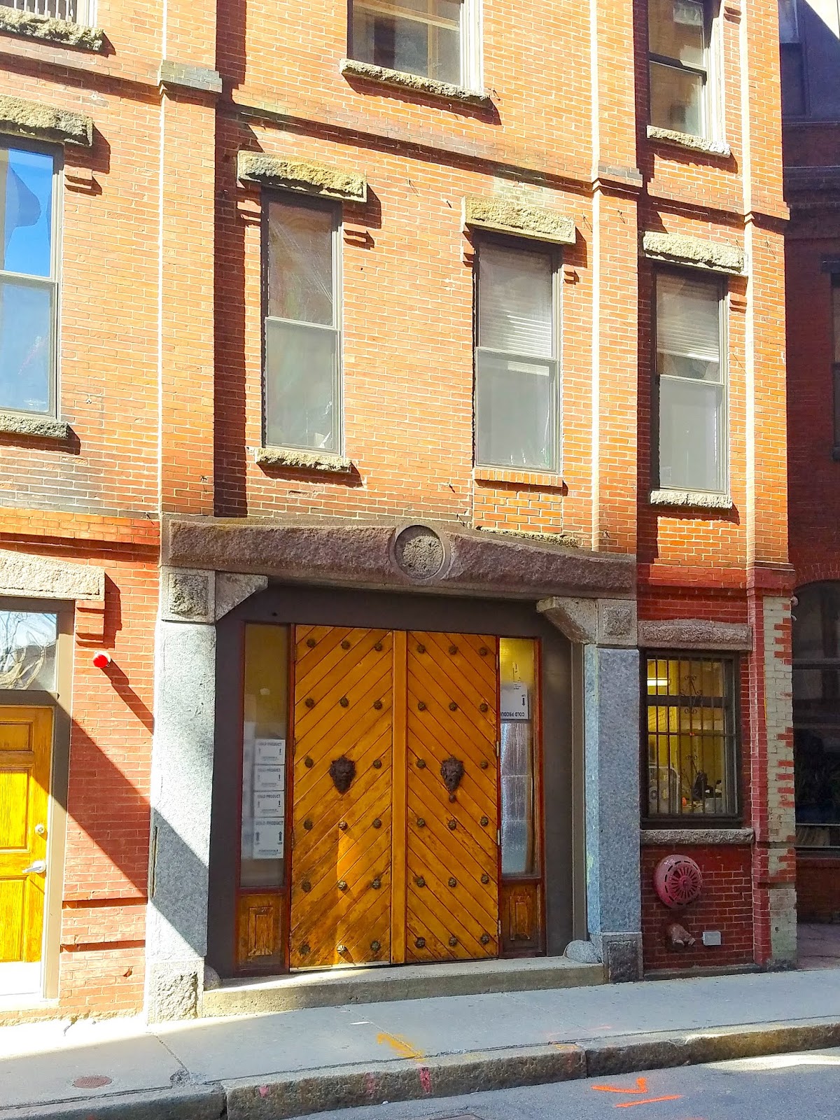
Tuesday, June 23, 2020

Walking Through the He(art) of Central Square

From Dave Brigham:

Since moving to the Boston area in 1990, I have certainly done plenty of stuff in the Central Square neighborhood of Cambridge, Mass., but I feel like I've shortchanged this bustling area. Like so many other areas of Boston and its suburbs, Central Square has changed in recent years -- think biotech, high-tech and gaming companies and the attendant apartments, especially in the area south of Massachusetts Avenue -- but I found plenty of backside charm (and LOTS of public art) on a recent couple of strolls through here (OK, so they weren't that recent...).

Astute readers of this blog will recall that last year I published a post about Central Square, albeit a much shorter one than this (see April 11, 2019, "Walk Like a Cantabrigian"). There is just the tiniest overlap in this post. There will be some rhyme and reason to this, mostly around the large number of murals in the area. There's a lot to get through, so grab a coffee or a beer or an edible and let's get after it!

Timing is everything in life. As I was rambling along the sidewalk on the west side of Massachusetts Avenue, I spied an open door leading to the alley between Irish bar Phoenix Landing and Italian restaurant Viale. I peeked in and saw the cool mural above. When I walked by another time, that door was closed. This mural was a sign of things to come on my adventures.

Below is a historic marker located on the side of a 7-Eleven at the corner of Pleasant Street and Massachusetts Avenue, near city hall. The marker reads: "CAMBRIDGE ATHENAEUM SITE OF A PRIVATE LIBRARY THAT BECAME CAMBRIDGE'S FIRST CITY HALL 1854-1890 LATER HOME OF THE PROSPECT UNION 1851-1922"

"The Reverend Robert Erskine Ely, a Congregational minister, and Francis Greenwood Peabody, a Harvard Professor, founded the Prospect Union. It was hoped by doing so to ameliorate the 19th century tensions between the Cambridge elite and the ever growing immigrant population, and also to offset the organizing power of labor unions," per a Cambridge Historical Commission document. Interesting...if we help the poor, they won't rise up against us!"

The alley above is located on Landsdowne Street, across from the Novartis Institutes for BioMedical Research, which are located in a former New England Confectionery Company (NECCO) candy factory (see January 5, 2019, "There Was No Way-fer Necco to Carry On"). The building is home to Star Bright Books, a store for kids and those who love them.

Below is the same alley. On the right is a brightly colored metal grate on what used to be a store of some sort. This building appears to connect to the adjacent Sunoco station, so perhaps it is used as storage for that business.

"CENTRAL TRUST CO." That's what the ghost sign says. I haven't found out much about the old banking firm. Below is a shot of the upper part of the building, which indicates it was ERECTED BY ASA P. MORSE in 1905. Morse was president of the Cambridgeport National Bank, as well as a builder and realtor and an alderman, and a member of the Legislature in 1869, and again in 1872.

Below is the Morse building on the left, as well as an awesome mural on the building in the middle.

This exquisite work of art -- painted by Marka27 and known as "Queendom" -- is just one of many that have gone up in recent years thanks to the Central Square Mural Project (CSMP). I mentioned this artist last year in the initial installment of my series about Somerville's Union Square (see August 25, 2019, "Union Square, Somerville, Part I: New Purposes & Grease Monkeys").

Let's look at some other murals in Central Square, some that are part of CSMP and others that aren't.

This is called "The Teachers Home," and it was painted by Caleb Neelon as part of the mural project. Below is a detail from Neelon's mural, which is located on the rear of the H Mart building.

The beautiful work of art below is on the front of H Mart. It pre-dates the mural project, as it was painted in 1994 on what was then the Harvard Food Co-op, per this article. It is called "The Potluck," and was painted by David Fichter.

The mural below, painted by the artist who calls herself Imagine, is located on the corner of Sidney Street and Massachusetts Avenue.

Imagine, aka Sneha Shrestha, is a Nepali artist who paints "Mindful mantras bridging Sanskrit scriptures & graffiti," per her web site. Below is a detail from the mural.

Below is "Cambridge and Beyond," a mural done by Percy Fortini-Wright for CSMP.

This work of art is located on the side of the former Cambridge Electric Light building at 719 Massachusetts Avenue.

Below is a work done by an artist who goes by Vyal One. I'm calling this one "Nocturnal/Diurnal," based on the words in the mural. Part of the mural project, it is located on the corner of Green and Brookline streets, on the back of the former TT the Bear's nightclub, which is now known as Sonia (and which is owned by the same folks who own the adjacent Middle East club). I really, really like this work.

Below is a work on the facade of Bao Nation, a Chinese restaurant that sits next to the above-referenced H Mart, and adjacent to the infamous Graffiti Alley (about which more below).

Per the Seen Around Boston blog, the main work, which was likely commissioned, was done by an artist who goes by Brandalizm (aka Brand Rockwell), and the art above the restaurant sign is probably the work of other folks.

To the left of the photo is Graffiti Alley, aka Richard B. Modica Way, which has showcased a revolving gallery of art since 2006, per Wikipedia. I don't know who the alley's namesake is/was, nor whose idea the alley devoted to artwork was, nor who/what owns the property. Below is a shot of the alley, with its multicolored glass canopy.

Below is a small sample of the type of work that local taggers paint here on a day-to-day basis.

Back over on Brookline Street, on the side of the Middle East Restaurant and Nightclub, is an amazing mural done by Daniel Galvez in 1992.

The L.A.-based artist restored the mural in 2017. I've been to countless shows at both the Middle East (upstairs and downstairs) and the former TT the Bear's, but had never really appreciated this artwork until walking around with my camera.Below is a detail from the mural.

On the adjacent Sonia nightclub there is a series of small paintings illustrating some of Earth's elements. They appear to have been done by students, but I'm not sure what age or what institution.

(Aluminum [top] and Cadmium [bottom]).

(Gold [top] and Manganese [bottom]).

One of my favorite recent public art trends is painting electrical boxes.

So much better than boring old battleship gray!

OK, now time for a random assortment of buildings and ghost signs and such.

The Barron Building is named for the late Carl Barron, a businessman, philanthropist and leader of the Central Square community. The City of Cambridge assessor's office dates this building to 1908.

Located on the side of the Barron Building is the ghost sign below.

You can probably make out the words "house," "boating" and "baiting." On this blog, I found out that, as I figured, this place was formerly called Prospect House. It was a meeting hall located on the upper floors, with retail on the ground floor, as today. Whereas at one time there was an outdoor equipment supplier here, now there is a Dunkin' and a Bank of America.

One of the most iconic ghost signs in the Boston area is the one below.

Located on the side of 875 Main Street (circa 1910), the current home of massage therapy joint Foot Heaven, this sign could be a hundred years old. As much as I love shooting ghost signs and researching them -- I recently did a Zoom presentation on these old advertisements for a committee of the Boston Society of Architects -- I haven't figured out how to determine the age of these fossils.

Nearby, at the intersection of Main Street and Massachusetts Avenue is the the little brick building at the center of the photo below.

Known as the William A. Taylor House and Store, this property "is one of the only remaining pieces of the former Lafayette Square, which is considered a historic structure that contributes to the Central Square Historic District listed on the National Register," per this 2016 document for the Mass + Main development (now known as Market Central).

This quaint piece of history has been incorporated into Market Central, a three-building residential development that includes retail. Just across Lafayette Square from the Taylor building is the property below, which faces Massachusetts Avenue.

Known as the Lamson Building, this is an MIT property that's split, oddly enough, between the Women's Independent Living Group, a dorm for up to 45 female students, on the left (seen above), and the Alpha Delta Phi fraternity on the right (not pictured). It is a former apartment building; I'm not sure where the name comes from.

Not far away along Massachusetts Avenue is the handsome building below.

Now home to Happy Lamb Hot Pot and People's United Bank, among other businesses, this property was built in 1926 and is known historically as the Moller's Furniture Store.

I'm bummed about the photo below. The light was fighting me, and there are trees in front of this property, and I just couldn't get a good shot. But you can get some idea of the majesty of this place, which is known historically as the Frank A. Kennedy Store.

Built in 1896, the Kennedy store was, I assume, affiliated with the Kennedy Steam Bakery that was once located next door. On the Salvation Army property now located on the former biscuit company web site, I found the plaque below.

Founded in 1839, the bakery in 1875 began building a massive brick complex housing multiple buildings. The company was the originator of Fig Newtons. Eventually, the company merged with the New York Biscuit Company to form Nabisco, which still makes a variety of Newton cookies. Below is the main part of the old baking complex, which many years ago was converted to mixed-income housing.

I snapped this photo several years ago, and at the time I figured Kennedy Steam referred to an old power plant. It wasn't until recently I learned it was part of a bakery.

A few steps away from the old bakery complex, along Massachusetts Avenue, is the Longfellow Building, below.

Built in 1893, it is home to the Clover Food Lab, among other businesses.

Just up Mass. Ave. is Cheapo Records.

In business since 1954, the record store is one of a dying breed. Filled with used (and probably new) records of all music genres, it's a great place to get lost for an afternoon. I've only been in there once, but I hope to get back there sometime in the post-COVID world. I bought a few albums; don't remember which ones, but they were old country LPs.

Two doors down is Teddy Shoes, in business since 1957.

I fear that both Cheapo and Teddy Shoes will not survive having been closed for the last few months, along with so many other businesses.

Also along Mass. Ave. I found a ghost sign for the former Sleepy's mattress store.
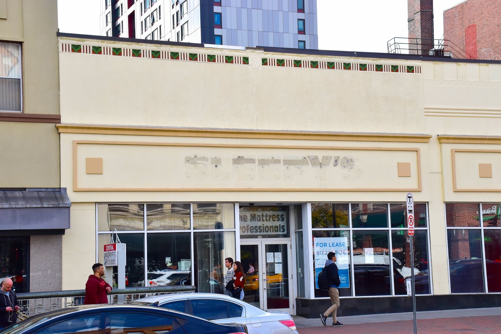
Sleepy's was acquired by Mattress Firm several years ago.

While very few are mourning the loss of Sleepy's, I sincerely believe that the city of Cambridge might just collapse in on itself if the Cantab Lounge were unable to survive the pandemic shutdown.

Around since, perhaps, the beginning of time, the Cantab is a dive bar that looks somewhat like an old Irish pub on the outside, with its fake stonework and green awning, and features poetry slams, a bluegrass night and more entertainment ranging from blues to country to R&B. The place was made legendary by Little Joe Cook, aka the "Peanut Man."

Cook, who died in 2014 at age 91, started playing at the bar five nights a week in 1979. "Before, there were bars that would have some bands playing in the corner with some acoustic music or whatever, but what Joe actually did was he brought a really big time show to a small bar," general manager Steve Ramsey said, in the above-linked Wicked Local article. "If you wanted to go see a big time band, you had to go into town, or in North Cambridge to a club called Tiffany’s, but those have all long past."

"The Philadelphia native gained fame in the late 1950s for his single, 'Peanuts,' which stayed on the Billboard charts for 15 weeks and was later covered by Frankie Valli, with the Four Seasons, and incorporated into commercials," per the Wicked Local article. "Cook appeared on 'American Bandstand' with his lesser-known song, “Let’s do the Slop,” about a dance move he created, and he toured the country, playing with the likes of B.B. King and Bobby “Blue” Bland." I saw Cook perform once at the Cantab, and he was great. He drove around town in a yellow Cadillac with the license plate "NUT MAN."

Green Street Grill has been around even longer than the Cantab.

The eatery's web site says it has been around since the Great Depression (it was founded as Charlie's Tap), and is home of the city's longest-standing liquor license. It closed at some point, and reopened in 2006. That's all I know.

Right next to Green Street Grill is the Greek American Political Club.

I like the looks of this place, and I also like that the joint is host to the Havana Club, which offers salsa dancing and lessons.

Right around the corner from the club is an amazing Greek Orthodox Church.

The Sts. Constantine and Helen church dates to 1917, per the Cambridge Assessor's office. I absolutely love the stained glass in the photo below.

On the opposite side of Magazine Street sits a church that's quite down at the heels, especially compared to its Greek neighbor.

The First Baptist Church was built in 1881, per Wikipedia. This stunning brick Gothic structure is the third First Baptist house of worship built on this site; the prior two, dating to 1819 and 1866, were destroyed by fire. When I took these photos last year, there appeared to be work going on inside and outside the church. I haven't been by in a while and am not sure what the building's status is.

On the north side of Massachusetts Avenue sits the beautiful St. Mary Orthodox Church.

The building on Inman Street has quite a history, as does the parish that occupies it. "Our present church, built in 1822, the second oldest church building in the City of Cambridge, was moved from Lafayette Square to Inman Street in the fall of 1888," per the church web site. "Even though the moving of the church was the largest ever undertaken in the City of Cambridge the cost was less than that of building anew on the Central Square site. Money saved from building construction was committed to a massive remodeling scheme."

As for the parish: "The history of our parish is one that begins in 1928, when a group of parishioners from St John of Damascus Church on Hudson Street in the South End of Boston decided to form St. Mary. In the beginning, services were conducted in homes an rented halls until a building was purchased in the South End in 1932. Arabic was the language of the neighborhood and Arabic was the language of the church services. Until 1945 the clergy of St. Mary's were Arabic speaking. Fr. John von Holzhausen became our spiritual shepherd in 1945, the first priest not of Middle Eastern descent and the first priest to use English during the services. With the post-World War II baby boom, and as more parishioners moved from Boston to its suburbs, the leaders of the parish sought a new location. They selected the Universalist Church on Inman Street in Cambridge."

Directly across from the church is Cambridge City Hall. It only seemed fitting for me to take a picture of the rear of the building.

Built in 1888-89, City Hall "was largely funded through a donation from Frederick Hastings Rindge," Cambridge-born son of a banking and shipping tycoon. Rindge was the founder of Malibu, California. City hall architects were Longfellow, Alden & Harlow, successors to H.H. Richardson known for Brattle Hall in Cambridge, the Hunnewell Building at the Arnold Arboretum in Boston, and several buildings in Pittsburgh. The bell tower on City Hall rises to 158 feet.

Now you know more about this vital neighborhood, and so do I.

Friday, June 12, 2020

Lechmere Is Dead; Long Live Lechmere!

From Dave Brigham:

I don't know for sure that this excavator will be employed to take apart Lechmere Station in East Cambridge, which is located in the background. Probably not, but the station will be razed before too long while a new station rises across Monsignor O'Brien Highway. It's all part of the MBTA's Green Line Extension project, which is slated to begin light-rail service to six new stations, as well as the new Lechmere station, in Cambridge, Somerville and Medford by the end of 2021.

Opened in 1922 by the Boston Elevated Railway, Lechmere station takes its name from the nearby Lechmere Square, which was named for "Colonial-era landowner Richard Lechmere, a Loyalist who returned to England at the beginning of the American Revolution," per Wikipedia. "His lands were later seized by the new American government." The station was totally bare bones a hundred years ago. Over time, a busway was added (which will remain open for the time being; shuttle buses will replace Green Line trolleys between Lechmere and North Station), as was a more substantial (although not very substantial) shelter area for train passengers.

The station hasn't been upgraded in, I wanna say 100 years, but that can't be true.

A new section will be added to the viaduct that runs from just east of Science Park Station in Boston to the intersection of Cambridge Street and Monsignor O'Brien Highway. The old section that connects to the old Lechmere Station will come down. In the photo below, the new viaduct section is at the top of the photo, while the old Lechmere is in the bottom.

Below, the new viaduct section is to the left, the old one to the right.

The Green Line Extension will continue from the new Lechmere Station (rendering here) north into Somerville -- stopping at a spur in Union Square, as well as stations in East Somerville, Gilman Square, Magoun Square and Ball Square -- and end in Medford near Tufts University.

I look forward to seeing the new Lechmere Station, as well as all the other ones. My son might not want to ride with me anymore by that point (he just turned 18), but I bet I can entice him. Especially if the Trolley Snacks & More gets a makeover for the new Lechmere.

Nine years ago, I randomly visited East Somerville and took pictures of some MBTA freight cars along New Washington Street (see June 14, 2011, "Graffiti Train"). This area is just steps away from where the new East Somerville Green Line Station will welcome passengers.

Friday, June 5, 2020

Cruising Around a Waterless Bay Village

From Pythagoras T. Gigglesworth:

Boston's Bay Village is a place out of time. Well, almost. There is development in this pocket of a neighborhood squeezed between the Theatre District, the South End and Back Bay, but for the most part this area is quaint, historic, quiet and charming. The feel is similar to that of Beacon Hill (see parts I, II and III of my series on that wonderful neighborhood), and for good reason. "The builders who were constructing extravagant homes on Beacon Hill settled in Bay Village, building smaller, more modest versions of the homes for themselves," per this good Boston Magazine primer on Bay Village. "They share virtually the same facades and layouts, but lack some of Beacon Hill’s more intricate details, like ironwork and decorative molding."

So why is this land-locked neighborhood that's nowhere near a body of water known as Bay Village?

"The western part of the neighborhood was originally part of the body of water known as the Back Bay, west of the Boston Neck isthmus," per Wikipedia. "This area was once known as South Bay, as the original waterline was in the area of Arlington Street.... In the 1820s, the neighborhood was landfilled... before the more extensive landfills of the adjacent Back Bay and South End neighborhoods. Through its history, the neighborhood has been known at different times as the Church Street District, South Cove, and Kerry Village."

I shot these photos last summer and fall, and wish I'd posted them sooner, because there are some really cool things to show off. Also, some things I need to post before they get knocked down....

Alright, let's start off with a bang....

These ghost signs are all on the rear of buildings along Stanhope Street, a short thoroughfare that is just outside the boundary of Bay Village, according to Google Maps, but I think the feel of this tucked-away spot fits the vibe. Many of the buildings along this little cut-through between Berkeley and Clarendon streets were once stables for Back Bay residents, and subsequent to that, auto body shops.

These ghost signs are important to me for two reasons: a) this spot is really little more than an alleyway, and I wasn't expecting to find anything here, so that was exciting, and b) I learned an important lesson while researching these signs on Flickr. On my first walk-by, I only noticed two signs, as I was in a hurry as I often am while traveling the city with my son. But looking at Flickr I found other signs that people had posted. I realized that I need to slow down and be more mindful of my surroundings when I'm out taking photos. The top sign is for Bascom's Inc., "the self-proclaimed 'largest wholesale and retail automobile supply house in the East,'" per MACRIS. I'm not sure if the other signs related to that business, or whether they advertised auto body shops that were also located here.

There are actually five signs in this short span! The fifth sign is below.

I found this one less exciting than the others, because there's no mystery to it, and because it's fairly recent. Bertucci's operates 58 restaurants, mostly in New England. It was founded in nearby Somerville in 1981. The Stanhope Street location closed at least 10 years ago.

The space that Bertucci's vacated has been occupied by Red Lantern, an upscale Asian restaurant and bar, since 2011.

This building and the ones adjacent date to 1874, I believe. The Red Lantern space has been a restaurant since at least 1937, per MACRIS, although there were some years it was vacant. While the building is historic and cool and really nice on the inside, it may get torn down. Last September, developers announced a plan to build a 300-room hotel tower on this site. Heavy sigh...with the coronavirus in full effect, I suspect that a) Red Lantern will go out of business if it hasn't already and b) this project won't happen for quite some time.

Below are more buildings along Stanhope Street.

On the far left is Red Lantern. In the middle is The Friendly Toast, one of six outposts of the local chain that serves breakfast, lunch and dinner in a funky environment. The tall building with the greenery in front is home to Brahmin, a restaurant and lounge. That building (#33) is another former stable; it was used "through the 1950s as a warehouse and for light industry such as upholstery and auto repairs," per MACRIS. It was converted to office space and a retail store for Hew England Radio and TV in the early 1960s, says MACRIS. The building at the right of the photo (#29) also dates to the 1870s and was a stable. "Reflecting the typical light manufacturing uses to vhich Stanhope St. buildings vere put in the 1910s and 1920s, 29 Stanhope vas the home of the Automotive Radiator Corp. and the Bay State Auto Radiator & Body ¥orks Co.," per MACRIS. "Subsequent tenants of the building included the Plymouth Colony Furniture Co."

Below is yet another cool building, a former stable, on Stanhope Street.

This is #21 (I think; numbering differs on MACRIS and on Google Maps). Built in the 1870s, it was originally owned by Amory Leland of Leland, Allen & Bates, a textile merchant company (I think). "In 1930, Levis E. Perry Sons Co., painters, occupied the building, and a sign manufacturer was the tenant in 1950," per MACRIS. I have no idea what's here now. There is a Walgreen's Community Pharmacy next door, and that might extend into this building.

The low-slung former stables of Stanhope Street are protected from the south by two taller buildings along Columbus Avenue. The Albert Pope Building (below) dates to 1880.

Here, the Pope Manufacturing Company built Columbia bicycles. In the 20th century, the building was home for a time to Cahners Publishing (the short lane that runs from Columbus Avenue to Stanhope Street is called Cahners Place). Founded in 1960, Cahners published trade and business magazines, including Variety and Publishers Weekly. In 1998, the building was converted to loft-style condos.

(Cool detail on the Albert Pope Building.)

Next to the Pope building is the beautiful property below.

I was looking up something on Google, perhaps for this post, and came across information for the Pledge of Allegiance Building. "What the hell is that?!" I said to myself. It's this building, which is also known as the Youth's Companion Building. That name comes from a magazine by that title that was published here from 1892 to 1915, per Wikipedia. The children's magazine was the first to publish the Rev. Francis Bellamy's "Pledge of Allegiance."

(The rear of the Pledge of Allegiance Building.)

Across Berkeley Street from the Youth's Companion building is the cool building below, which sits at one end of a row of apartment buildings along Cortes Street, overlooking the Massachusetts Turnpike.

I love the funky window at the upper left. I haven't found out much about this place. The City of Boston's assessing department says it was built in 1899.

Isabella Street, parallel to and just north of Cortes Street, is home to the former Our Lady of Victories Church, which, you won't be surprised to learn, is being converted to condos.

The circa-1883 church and adjoining rectory are being redeveloped as The Marc, according to this Boston Herald article. "An official decree from the Roman Catholic Archdiocese of Boston...attributed the closing to the absence of need for pastoral care in the French language, the very small and decreasing number of parishioners, the inability of the parish to sustain itself financially and the inability of the archdiocese to provide sufficient resources," per the article.

Below is the rear of the complex, where you can see new additions to the old church.

There are cool details on the old church complex, of course.

I'm curious to return and see whether the old doors and windows have been refurbished.

(Can you tell I enjoyed walking around this old church and taking pictures?!)

The developer, New Boston Ventures, has experience converting former houses of worship to living quarters. The company turned the old Holy Trinity German Catholic Church in the South End into The Lucas (see December 31, 2019, "From Holy to Housing").

Just up Isabella Street I spied the shuttered business below.

Located at #6, this little old place has an apartment above retail space. I peeked in the window and door and could tell it was an old shop of some sort, perhaps a hat shop. It may a little too far off the beaten path for another store to succeed here. Maybe an artist studio?

At the eastern edge of Bay Village, at the intersection of Charles and Tremont streets, sits a cylindrical building with an interesting/confusing past, both in the structure itself and what it sits upon. It also has a potentially intriguing future.

This is another former church. Built in 1963 (or 1950 or 1975...Jesus, Internet, why is this so difficult?), the round brick edifice was home to a Church of All Nations congregation until pipes burst inside in 2002. After sitting empty for years, the place was taken over by a company called Torus in early 2015. From the little I've gleaned online, Torus was a nightclub. Or a promotion company. I don't know (Jesus, Internet, why is this so difficult?). The building is owned by Morgan Memorial United, which is related to the outfit (or perhaps is the outfit...) that operates Goodwill Industries. "In 1902, the Reverend Edgar J. Helms of Morgan Methodist Chapel in Boston started Goodwill as part of his ministry," per Wikipedia. "Helms and his congregation collected used household goods and clothing being discarded in wealthier areas of the city, then trained and hired the unemployed or impoverished to mend and repair them. The products were then redistributed to those in need or were given to the needy people who helped repair them."

This building's history is a little hard to follow but its future looks very, well, futuristic. The proposed new 333 Tremont, a 21-story tower, doesn't fit into this neighborhood at all. But there is a saving grace.

You see, the unique, probably-soon-to-be-demolished round building was built over the former Pleasant Street Portal to the old Tremont Street Subway. "The portal and the section of tunnel connecting it to Boylston (station) served Green Line streetcars from 1897 to 1901, Main Line Elevated (Orange Line) trains from 1901 to 1908, and streetcars again from 1908 to 1962," per Wikipedia (this gives credence to the built-as date of 1963). Touloukian Touloukian, Inc., the developer that wants to build a space-age, net-zero luxury building on the site, has included a tantalizing element to the project on its web site:

"This project feature proposes the re-use of an abandoned MBTA train tunnel as a new public way to connect the site to significant green space and transit stops. Opened in 1897, the Pleasant Street Incline was an entrance to the underground train network for streetcar lines."

The "significant green space and transit stops" must refer to Boston Common and the Boylston subway station on the Green Line. That would be an amazing feature if the developer can pull it off.

On Arlington Street, on the back of the Josiah Quincy Upper School, I spied this cool plaque.

Below Abraham Lincoln's bust is the complete text of the Gettysburg Address, which the 16th President of the United States gave at the official dedication ceremony for the National Cemetery of Gettysburg in Pennsylvania, on the site of one of the bloodiest and most decisive battles of the Civil War. It is considered one of the most important speeches in American history, as it honors the dead, rededicates the nation to freedom and declares the U.S. government "shall not perish from the earth." There's no indication on the plaque about what group sponsored its placement on the back wall of the school. I believe this was a common thing to do in the late 19th and early 20th centuries.

Along Charles Street, on the fringe of Bay Village where it meets the Theatre District, I found this lovely blue door with a wonderful rusty patina.

This is the backside of 80=84 Warrenton Street, which is a Boston Edison utility facility. The building dates to 1923.

Steps away, at 79 Broadway, is Bay Village institution Jacque's Cabaret.

I would've gotten a better shot, but there were a couple of guys hanging out in front, and I didn't want them to think I was a weird stalker taking their picture. Anyway, Jacque's opened in 1938, and became a gay bar in the mid-1940s, per this article. "After serving as the city's only lesbian bar from the late 1960s to the early 1970s, Jacques evolved into a venue for drag performers, which remains its focus to today," per the article.

I don't remember what street the buildings below are on, but I love the contest.

OK, ready for something completely unexpected?

This plaque over a doorway on Melrose Street is for Paramount News, the name of newsreels produced by Paramount Pictures from 1927-1957. According to this article, "It’s a two-bedroom, 2.5-bathroom, 1,568-square-foot townhouse ...located in the former Paramount News Building. The home is open concept and features stainless steel appliances, a private deck, and a bonus entertainment room." In the first half of the 20th century, Bay Village was "once filled with speakeasies, movie distribution centers, and movie theater equipment companies," per the article.

God, I love finding out stuff like this! And I was really excited to stumble across the next thing....

I knew right away that this was a former fire station. These places are usually pretty easy to pick out, but they rarely have such cool signage carved into their facades. Located on Church Street, this is the former, well, it's the former a lot of things, according to this article.

"This firehouse was built in 1869 for Hose Company 8 (South End), which moved in, on April 1, 1869, from their former quarters on Warrenton Street near Tremont Street....The building was split into two functions: Firehouse on the left side, Ward Room on the right. Ward Rooms were used in the same context as present-day community centers. Later, the Fire Department took control of the whole building....Hose 8 was disbanded and Chemical Company 2 was organized here on April 25, 1874. Chemical 2 was disbanded on July 2, 1920. Engine 26 moved in for a brief stay due to renovations at their quarters at 18 Mason Street, Downtown. Rescue Company 1 moved in on June 5, 1922 from their old quarters in Fort Hill Square. On October 9, 1925, the High-Pressure hose wagon of Engine 35 moved in, as their old house at 18 Mason Street was closed. Rescue 1 and the Hose Wagon of Engine 35 remained here until the new firehouse at 194 Broadway opened on April 17, 1928."

This property has been a private residence for quite some time.

I'm going to wrap up the post on a somber note. The Cocoanut Grove fire is one of the most tragic stories in Boston's history. For just about as long as I've lived in and around the city (30 years, give or take), I've heard about the November 28, 1942, nightclub inferno that claimed 492 lives. For decades, the story lived in my mind, but the location of the tragedy didn't. I had no idea where the horrible event had taken place. It was only last year when something passed across my mental transom that made me understand that the fire had occurred in Bay Village. So I sought out the site.

The club stood at what is now the intersection of Piedmont Street and Cocoanut Grove Lane. There is a plaque at the corner, indicating that overcrowding, locked exit doors and toxic flammable furnishings contributed to the huge loss of life.

Sorry to end on such a bummer.

Way Down Yonder in Pawtucket, Part II

From Dave Brigham: I ended my first post about Pawtucket by discussing a metal sculpture of Rev. William Blackstone, who is considered Rho...