Saturday, April 25, 2020

Charlestown Jaunt, Part I

From Dave Brigham:

This is first installment in a three-part series about Boston's Charlestown neighborhood. I will cover all the usual stuff -- monuments, statues, churches, old school buildings, gardens. Everything I photographed, researched and wrote about in these posts is in the parts of Charlestown that are easily reachable by subway. As regular readers know, I regularly take T trips with my son, so the areas of the Hub I explore are all at least somewhat close to stops on the Blue, Red, Green and Orange lines. I hope you enjoy taking this adventure with me!

Separated from the North End by the Charles River/Boston Harbor, Charlestown is Boston's oldest neighborhood. "Charlestown was laid out in 1629 by engineer Thomas Graves, one of its earliest settlers, in the reign of Charles I of England," per Wikipedia. "It was originally a separate town and the first capital of the Massachusetts Bay Colony." When I moved to Boston in 1990, the neighborhood was nearing the end of its run as an Irish Mafia enclave. "In the late 1980s...Charlestown underwent a massive Yuppie gentrification process similar to that of the South End," says Wikipedia. "Drawn to its proximity to downtown and its colonial, red-brick, row-house housing stock, similar to that of Beacon Hill, many yuppie and upper-middle-class professionals moved to the neighborhood. In the late 1990s, additional gentrification took place, similar to that in neighboring Somerville. Today the neighborhood is a mix of yuppies, upper-middle-class and middle-class residents, housing projects, and a large working-class Irish-American demographic and culture that is still predominant.

Not long after moving to Boston, my buddy Jim, who grew up in Somerville, drove me through South Boston. I recall a much rougher neighborhood than what this area is now. I saw at least one pro-IRA mural, which I found shocking, although I shouldn't have. I'm guessing Charlestown would have looked quite the same back then. Anyway, on to the results of my tour....

Might as well start with the obvious: the Bunker Hill Monument.

Standing 221 feet tall, the monument was built between 1825 and 1843, replacing a previous 18-foot wooden memorial. The obelisk, which commemorates the 1775 Battle of Bunker Hill during the Revolutionary War, actually stands on Breed's Hill, where most of the fighting took place in that early battle. Although I've lived in the Boston area for 30 years, I've never climbed the monument. The one time I visited with my kids, the place was closed for construction.

(The Bunker Hill Monument dominates the south-central portion of Charlestown.)

In Galvin Memorial Park along New Rutherford Avenue, hard by I-93, I found the two paintings below.

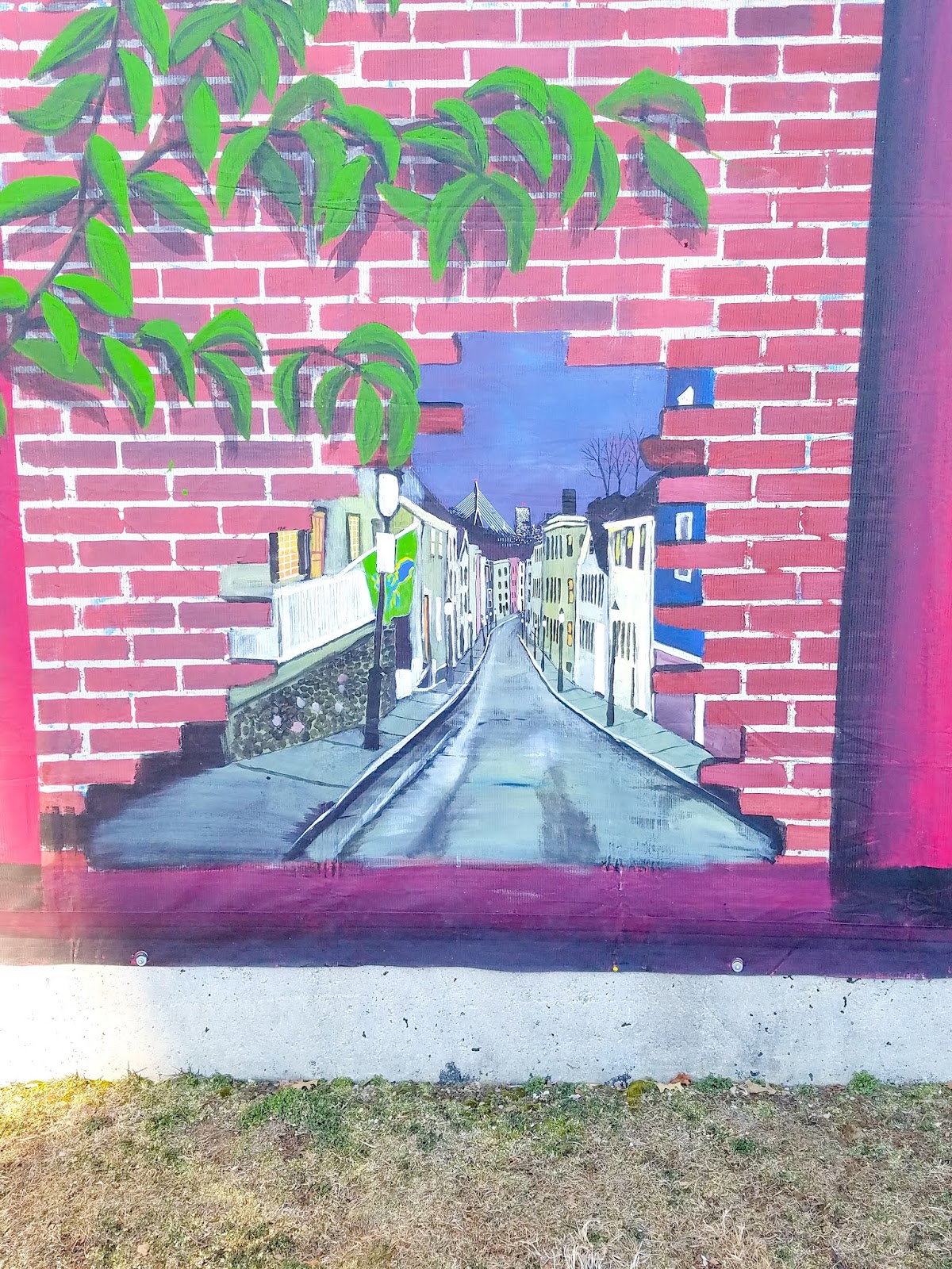
The top one depicts what I imagine is the Battle of Bunker Hill. The lower one portrays a lovely narrow street with quaint Colonial homes. I haven't found any information about who did these works of art.

Not far from Galvin Park is City Square Park. "Located on the spot of the founding of Charlestown in 1628, City Square Park occupies land where John Winthrop, the first governor of Massachusetts, built his home," per this American Society of Landscape Architects web site. "Kept as an open square for much of the early part of the nation’s history, several arterial roads converged on this space by the 1950s. In order to restore the open character of the space, beginning in the 1970s, the Central Artery North Area project moved all of the main roads into tunnels under the site."

The result is a lovely, tree-shaded park with benches, open space and historic plaques and memorials galore.

The flag pole in the middle of the park marks the site of the first Colonial settlement in Charlestown in 1629. "On this summit was built the Hill Fort with palisades and flankers," the flag base reads in part.

(This plaque is one of many in the area near the flag pole. This one also marks the site where the first settlement was laid out.)

The one below indicates that one of the first schoolhouses in the Massachusetts Bay Colony was built on this hill. Schools stood on this site for more than three centuries afterwards.

Below is a plaque showing the Arbella, the flagship of the Winthrop Fleet, upon which Gov. John Winthrop and others transported the the charter of the Massachusetts Bay Company from England to Salem.

Lastly, this plaque shows a likeness of a windmill built on the hill in 1635 to grind grains harvested nearby.

Also located in City Square is Charlestown Veterans Memorial Park, below.

It is dedicated to Korean and Vietnam war veterans, including, of course, "those who made the supreme sacrifice."

There are other, more lighthearted plaques in Charlestown. The one below for Samuel A.C.W. Donnell, for instance.

Located at the corner of Salem and Main streets, this marker says: "In honor of Samuel A C W Donnell, 1916-1982, He led the way to Charlestown's renewal by saving three houses at 81 Warren Street and 2, 4 and 8 Salem Street. Sam often gave advice to others in renovating the older houses he loved, often donating his own labor as well. Given by friends, June 7, 1985”. Zoom in and be impressed by his hat, beard and mustache!

Donnell worked to preserve extremely important features of Charlestown. The marker below honors a hometown boy made good.

Located on an outside wall of the Charlestown Boys & Girls Club, this plaque recognizes Charlestown as the "hometown" of NFL Hall of Famer Howie Long (the plaque was installed in 2011 by the Pro Football Hall of Fame and Allstate Insurance). Although Long was born in Somerville, he was raised in Charlestown, per Wikipedia. He played 13 seasons for the Raiders franchise, and was named an All-Pro eight times.

Let's move on to churches and holy statues.

Across the street from the Boys & Girls Club is the First Church in Charlestown.

The congregation was founded in 1632 (!); among its early ministers was John Harvard, who bequeathed money to a college that was eventually named in his honor. Perhaps you've heard of it. More importantly to my history, he also gave his name to a small East Coast chain of brew pubs.

Anyway, the church's meeting house was burned during the Battle of Bunker Hill. In 1911, the congregation merged with the Winthrop Church and moved into its current building on Green Street, per the church's web site. In 1957 a major fire destroyed the sanctuary and steeple. Members do most of the restoration and rebuilding work. During Boston's school busing crisis in the late '60s and into the '70s, the church became a sanctuary for black students who waited nearby for a bus. "Bricks and rocks are thrown into the windows of the sanctuary. The windows are still boarded up from the damage." Well, that answers the primary question I had about why the church looks the way it does. Jesus, who throws bricks and rocks through church windows?!

At the corner of Warren and Winthrop streets sits the St. Catherine of Siena Chapel. I took a picture of the front of the church, but it wasn't so great. So here are some details.

Officially, this parish is known as St. Mary-St. Catherine of Siena since a 2006 union of the churches in which they now use the St. Mary facilities. "In 1828, Bishop Joseph Fenwick established St. Mary’s, the very first Catholic parish in Boston. That is, it was the first parish to be established separate from the Cathedral of the Holy Cross," per the church's web site. St. Catherine was founded in 1895. In the rear of the church is a peace garden, below.

Across Winthrop Street is the former St. Mary's School, below. The building has been incorporated into the Constitution Co-op affordable apartment complex for seniors.

Below is the former St. Catherine of Siena School and Hall on Tufts Street. The building is now home to the NEW Health Center.

Below are two shots of an annex building behind the school, which I believe was used by the school. The entire property, including the church (which I will get to in a minute; you will be surprised at its current use....), sold for $1.4 million in 2013. Some in the Catholic community thought the archdiocese should have gotten more money for the sale.

As for the church....

It's a Dollar Tree discount store. Seriously. I couldn't believe my eyes when I walked by this place. I've seen churches turned into apartments/condos, private single-family residences and restaurants. But never a Dollar Tree. Since 2004, the Boston Archdiocese has shuttered dozens of churches, due largely to the priest sex abuse scandal, as well as declining membership. Other buildings have become condos, while some have been torn down in favor of hockey rinks and other buildings.

The final church on my tour -- and believe me, there are plenty of others I skipped -- is St. Francis de Sales Parish on Bunker Hill Street.

What a beauty! The building dates to 1862; the parish was founded three years prior. Born in France in 1567, Francis de Sales was a Bishop of Geneva and was sainted in 1665.

On the grounds of the church is a statue of Saint Florian, below. He is "the patron saint of Linz, Austria; chimney sweeps; soapmakers, and firefighters," per Wikipedia. "St. Florian is also the patron of Upper Austria, jointly with Saint Leopold."

Next door is the former convent associated with the church (below). Built in 1901 for the Dominican Sisters who staffed the St. Francis school, the building is now the church's parish hall, I believe.

Across from St. Francis de Sales is a statue of the Virgin Mary (I think), dedicated to the Irish patriots who fought and died at the Battle of Bunker Hill.

Southeast along the same street is the Bunker Hill Burying Ground.

Used for burials since perhaps as early as 1801, the cemetery was originally intended for the use of the town's poor, but eventually it was opened up to other citizens, per the City of Boston web site.

I've covered former parochial schools, so how about some former public ones?

Located on Baldwin Street, the Bunker Hill School opened in 1866. It is now condos, natch.

The former B.F. Tweed School, below, is located in Sullivan Square, at the confluence of Rutherford Ave., Cambridge Street and Main Street.

I haven't found anything out about the school or the man it was named after. It is now home to a cycling studio and a fitness gym.

Speaking of things I can't dig up information on...

This is the James Brown House, circa 1855. I would love to report that this is where The Godfather of Soul was born, because, well, this:

But I don't know who circa-1855 James Brown was.

Funny that a house with a historic marker isn't searchable online, but the place below, which I randomly stumbled across, and which has no plaque upon it, has an entire article written about it.

Built in 1808, 23 Pleasant Street may have been the first house on the little roadway, per this Patch article. "The gambrel house...is, according to Boston Landmarks Commission, part of Charlestown's small collection of late Georgian gambrel houses," per the article. "Records show that members of the Kettell family, who lived in Charlestown from the birth of Joseph Kettell in 1641, were the original owners of the house. (John Kettell, a descendant, was a member of the Massachusetts House of Representatives between 1809 and 1812.)"

There are so many cool houses like this in Charlestown, Beacon Hill, the South End, Bay Village and other neighborhoods. I love when I take a random photo and it turns out that somebody else found it interesting enough to write a short news article about.

I love shooting details of all sorts, as you've no figured out. Below is a sign for Washington Street, placed right into the building.

The building is 34 Harvard Street, right across the park I mentioned above with the flag pole and all the historic markers. Built in 1880, this lovely brick structure is a one-family home assessed at just under $2.5 million.

I'm going to wrap up with the wonderful community garden at the intersection of Main and Bunker Hill streets.

Gardens for Charlestown was created in 1976 out of a "rubble-strewn lot owned by the Boston Redevelopment Authority," per the organization's web site. "The City's plan to construct a school on the site did not go forward, and the property began to attract unsavory uses. A handful of residents cleared enough land for a few vegetable plots, and the Garden was born."

It's a very peaceful spot.

(In the background in the photo above is a former fire station, which is now home to a community theater. I'll share photos and more information in a subsequent post.)

In the next post, I will cover some cool architectural details, a neat old clock, a former armory, some named buildings, the old firehouse near the community garden, and much more.

Wednesday, April 22, 2020

Dried Up

From Dave Brigham:

Despite having three different types of signs to advertise its services, Rite-Way Dry Cleaners on Hudson Street in Cambridge, Mass., went out of business. I'm not sure how long it was in operation, or when its business dried up. If you're interested, the space is for lease.

Rite-Way is just down the street from another shuttered business, Evergood Market, which I wrote about last year (see May 29, 2019, "Evergone Market").

Friday, April 17, 2020

Boston's Got a Big South End

From D. Anathopolous Brigham:

Like Boston's North End, the South End has countless nooks and crannies to explore. I haven't patronized any of the neighborhood's top-shelf restaurants and clubs over the years, but I have found a lot of the lesser-known gems that we all love at this blog (see October 12, 2019, "End to End in Boston's South End," July 26, 2019, "Former Oasis in Boston's South End An Abandoned Mystery," June 29, 2019, "Back Streets, Oh Boy" and February 23, 2019, "Exchanging Flowers for Life Science").

Let's dive in!

Starting off with a bang...this abandoned building is an outlier in the neighborhood, sandwiched between two elegant brownstones. Located at 1654 Washington Street, this place brings down the neighborhood. I was shocked to see a building in this state of decrepitude. I haven't found out anything about it. While I hate to see places like this, it sure makes for some good photography.

There are even faux window coverings on it, so obviously it's been in decay for years, and people are making at least a minimal effort to pretty it up.

Let's move on from a door that is beautiful in its own decrepit way, to an ornate entryway unlike anything I've ever seen.

I don't remember where in the South End this is. You should wander around until you find it, like I did. It's like a church or museum display. I wonder: can you even walk in or out of this door?

The statues would be enough to make this place stand out.

But the door details just put it wonderfully over the top.

And now how about a social club doorway....

Located on Albany Street, Pontiaki Estia of Massachusetts is a Greek religious, cultural and social club that has been around since 1970, I believe.

OK, enough doors. How about a one-of-a-kind memorial?

"You Know The Deal," it says above a picture of the late Fred McDuffie. Born in 1930, he died in 2012 and was "A Friend to All." I found an obituary online that I believe is the correct one. If so, Mr. McDuffie had 16 children and 31 grandchildren. This is located on the side of Gaslight Brasserie.

McDuffie's memorial is on the same building as the ghost sign below.

Why is there a sign that says "218 WABASH AVE. CHICAGO" on the side of a building in Boston? I don't know. I posed the question on Instagram a while back, and the closest thing I got to an answer was, "Emerson Piano was in 560 Harrison and I believe that was the address of the Chicago location." Well, I searched online and there was an Emerson Piano in both Boston and Chicago, but the Boston one was on Boylston Street and the Windy City one was at 195 Wabash.

Alright, let's get to a bunch more ghost signs.

Located at the SoWa Open Market complex in the South End, this ghost sign tried to keep its secrets. Took quite a bit of searching online, including on Flickr, but I finally figured it out. The words "wise one" at the bottom were the key, as that is part of a tag line for Just Suits cut plug tobacco. And I could make out the words "real tobacco" at the top.

But there is still a complicating factor here. This building is 520-524 Harrison Avenue, which, according to my friend MACRIS, is the former Emerson Piano Co. building. Above, I indicated there was an Emerson facility on Boylston Street. Perhaps that was the corporate office; this building was the factory.

Built in 1882, the Emerson factory built 80 pianos a week. After Emerson moved, A.M. MacPhail Piano moved into this space. Hub Hosiery Mills moved here in the early part of the 20th century.

Below is a ghost sign on Appleton Street, at the intersection with Tremont.

I haven't been able to solve this one. What I see is the word "IDEAL" and then the rest is too fuzzy for me. Any help is appreciated.

The sign below is on Bradford Street, on the corner of Shawmut Avenue. It is located on the side of an outlet of Polka Dog Bakery.

The only stuff I've found online about Boston Creamery are case studies done by college students about the business. But they are locked down and I can't find out when the business launched or where it was or when it melted down.

Northeast along Shawmut Avenue, at the corner of Dwight Street, I spied this lovely old sign.

Again, I haven't found out anything about Imperial Marble.

Inside that building is Shawmut Place, a tailor shop.

Now I'm gonna jump back over to the SoWa neighborhood for a well-known and large work of art.

Located on the side of a Prime Storage facility along Traveler Street, this beautiful mural used to be viewable from the Southeast Expressway. Painted by Ronnie Deziel in 1998, the 125-foot-tall by 100-foot-wide work is now largely hidden from highway drivers' view by a new apartment building. Back in 2015, the artist repainted the whole thing to make it more awesome.

Just around the corner from this great work of art is a beautiful building where important work is done.

The Pine Street Inn opened its door to Boston's homeless population in 1969. The organization provides housing, emergency services, and workforce development to support nearly 2,000 men and women each day, per its web site. Its building is the former Boston Fire Department headquarters, which was built in 1893.

I'm gonna finish up with two named buildings.

Located along Warren Avenue, this is the rear of the Boston Center for the Arts, which faces Tremont Street and houses the Huntington Theatre Company and the Community Music Center of Boston, among other arts facilities. What else is that building known for? The Cyclorama! Built in 1884 to house the Cyclorama of the Battle of Gettysburg, a 400-by-50 foot cyclorama painting of the Battle of Gettysburg, per Wikipedia, this place is a local legend. And from 1923 to 1963, this place was also home to the Boston Flower Exchange, which is what that hunk of concrete in the upper middle of the photo above says.

Finally, the Renbrandt.

No, that's not a typo.

I did a double-take when I spied this place. Renbrandt, Inc., was a tool and metalworking business that occupied this small building near the intersection of Massachusetts Avenue and Washington Street, per this real estate web site. Developers recently added four stories, and it now features commercial space on the ground floor and nine luxury apartments. "The historic structure was originally built in 1915 and operated as a bean factory," per the web site. "Throughout the years the building housed several different business operations including an automotive repair shop, dry cleaner and bookie joint."

Love that history!

Sunday, April 12, 2020

Crossing Through More of Boston's Downtown

From That Same Old Guy:

Boston's Downtown Crossing area is a great place to shop, stroll, eat and look for the city's history. I've covered much of this ground before (see December 26, 2019, "A Little Boston Street With Big History", December 21, 2019, "Just a Typical Day Wandering in Boston" and April 3, 2019, "Sweeping Through Bromfield Street").

In this post I feature some black-and-white photos, which I don't do much but sometimes it just seems right. This post is chock full of things that I either missed or ignored on previous walks through Downtown Crossing. That's why I love exploring Boston and other cities: there's no shortage of oddball, historic, quirky or dilapidated stuff to shoot.

Let's start with a ghost sign that I somehow missed on countless walks through this area.

This is the rear of the former Gilchrist Department Store, at the corner of Washington and Winter streets. I haven't been able to determine what product or store this advertisement promoted. All I can make out is PROGRESS at the bottom of the sign. Built in 1912 and home to Gilchrist until 1976, this building is now home to the Corner Mall and to offices. It has some cool details.

The classic grotesque above is just one of many on the 10-story building.

Directly behind the Gilchrist building is the William T. Andrew Building, yet another gem that I've overlooked through the years.

Built in 1852, this property is a rare "surviving example of mid-19th century Italianate brick commercial architecture, largely intact above the first floor level," per its MACRIS listing. Many buildings of this vintage in the city were destroyed in the 1872 fire, which was stopped at Washington Street. Over the years, this building has been home to, among other businesses, an auctioneer, a dry goods business, a gas fixtures operation, a cafe and a beauty salon. There is currently retail on the ground floor; I'm not sure what, if anything, is located on the upper floors.

Just down Washington Street from the Gilchrist building is the Blake and Amory Building, below.

Built in 1904, the Blake and Amory was designed by Arthur Bowditch, the architect who designed the nearby Paramount Theatre and the Myles Standish Hotel in Kenmore Square, which is now a Boston University dorm. An addition, the 11-story Blake section, was built in 1908. For many decades the building served tenants in the apparel industry.

A little further south on Washington Street is the Opera House.

Opened to the public in October 1928, the Opera House has featured films, vaudeville shows, operas, touring Broadway productions over the years. It was originally known as the B.F. Keith Memorial Theater, named for one of the fathers of vaudeville. I wrote about this place last year, but hadn't noticed this plaque until recently (see September 20, 2019, "A Peek Behind the Curtain of Boston's Vaudeville History").

I'd taken lots of photos a while back along Bromfield Street, which runs between Washington and Tremont streets (see April 3, 2019, "Sweeping Through Bromfield Street"), but I poked my head down an alleyway that I had to skip that earlier trip because of a locked gate.

This is the side of 20-30 Bromfield, which was designated a Boston Landmark by the Boston Landmarks Commission in 1983.

Across the street is Colonial Trading, which I didn't take a picture of for the aforementioned Bromfield profile. I like the hand-painted sign, but I'm not sure what Native Americans would think of it.

Around the corner from Colonial Trading, on Province Street, is the Hub Pub.

The Friendliest Pub in the Hub has been around since the late '90s, I believe.

Province Street intersects with School Street. On the sidewalk in front of Boston's Old City Hall is this plaque commemorating the first site of Boston's Latin School. The plaque normally looks better than this, but it was covered with ice melt when I was there.

Established in 1635, the Boston Latin School is a public exam school, and the oldest public school in the US of A.

Back down Washington Street, just past the Blake and Amory Building, on West Street, is the fantastic Brattle Book Shop.

Founded in the Cornhill section of Boston in 1825, the store has been in the hands of the Gloss Family since 1949. The shop stocks "250,000 books, maps, prints, postcards and ephemeral items in all subjects," per its web site. "In addition to its general used and out-of-print stock, The Brattle Book Shop also maintains an inventory of first editions, collectibles and fine leather bindings in its rare book room."

One street over from the book shop, on Temple Place, is this cool old-school entrance to the Downtown Crossing subway station.

At the corner of Water and Devonshire streets, next to the hidden gem of Spring Lane (see December 26, 2019, "A Little Boston Street With Big History), is this neat subway entrance.

On Tremont Street, near the Brattle Book Shop, is this most interesting McDonald's.

Located at 146 Tremont Street, this little beauty has been here since 1899. Per the Internet, the property has been home to John O'Neill's singing studio and Arthur Schmidt's Music Store, among other businesses. This place resonates for me not just architecturally and historically, but also personally. Long story short: in college I watched my buddy Jim walk into this McDonald's behind a guy who promised he could sell us tickets for the Echo & the Bunnymen show that night at, hmm, either the Opera House or the nearby Wang Center. The guy bolted with our money out the back and we never saw the show. When our buddy Ken showed up after calling his girlfriend from a payphone, he was pissed, understandably. While waiting for Jim, I stood outside a liquor store nearby and talked to a creepy alcoholic who offered me a sip of his beer he had in a paper bag. I wrote a story about it for -- shameless plug alert! -- my collection of short stories, "(C)rock Stories: Million-Dollar Tales of Music, Mayhem and Immaturity."

Along Bedford Street, where Downtown Crossing, Chinatown and the Theatre District meet, I found this scene out of the past.

I can't find much about Clement's Textile shop online, but since it was located near the hub of Boston's old garment district, I'm guessing it opened a long time ago and went out of business within the last 10 years.

Right around the corner from Clement's, on Kingston Street is J.J. Foley's Bar & Grille.

While it's been open since 1959, this place is the "baby brother" of J.J. Foley's Cafe in the South End, which has been around since 1909.

Let's finish up with some more black-and-white shots. Below is the Merchants Building, located at the corner of Kingston and Summer streets.

Built in 1901, the Merchants Building was designed by well-known Boston architect Arthur Bowditch. A Beaux Arts beauty, it hosted tenants including the Hawes Hat Company, the Bates Shirt Company and Sages Trunk Depot, per MACRIS.

The last two buildings are located where the Financial District, Downtown Crossing and Chinatown meet. Both were incorporated into the 125 Summer Street tower project many years ago, along with two other old structures. "These four buildings form the base for the tower, which then is set-back and rises 18 stories," per MACRIS. "The building has an L-shaped plan which accommodates an existing air-shaft for the Central Artery."

"This building utilizes the practice of facade-ism (sic) in which only the facade of a building is retained, the remainder demolished and the facade incorporated into a new structure," per MACRIS. "Four buildings completed in 1873-1877 are incorporated into this structure in an attempt to retain the historic context and scale of the area." I've written about façadism before (see April 6, 2019, "UPDATE: Cashing Out (And Learning About Facadism").

I haven't found out any specifics about the building above, with "HA" carved in to the facade. As for the building below, however, I uncovered a few details.

The JPC building was commissioned by, and named for, Joseph P. Cooke, as a warehouse for Boyd, Corey and Ahl, shoe dealers, per the Boston Redevelopment Authority's and Boston Landmarks Commission's 1983 report on the Commercial Palace District. It was designed by Ware & Van Brunt, an architectural firm known best for First Church (Congregationalist) in Boston, Memorial Hall at Harvard University, the Episcopal Theological School in Cambridge and the Third Universalist Church in Cambridge.

Checking Out Dudley Street in Roxbury...and a Historic, Pre-Civil War House

From Dave Brigham: As part of a series of quick-hit jaunts through Boston this spring, I checked out the outer reaches of Nubian Square, m...