Friday, June 23, 2017

A Walk Through Weston's History

From Dave Brigham:

This historic home is the gateway to the Kendal Green Historic District in Weston, Massachusetts. Known as the Hobbs-Hagar House, it was built in 1786 by Isaac Hobbs Jr., one in a long line from that family to live, work and employ folks in the old farming town that more recently has become a swanky Boston suburb.

"In 1729, Josiah Hobbs purchased 122 acres along North Avenue at the heart of the Kendal Green Historic District, including water rights to what is now known as 'Hobbs Brook,'" according to the Weston Historical Commission. "The Hobbs Tannery, which may have been established as early as 1730, was among the first tanneries in the Massachusetts colony and was so well-known that it was a custom in early days to locate houses and people in Weston by their distance from the tannery."

Across North Avenue (aka Route 117) from the Hobbs-Hagar House sits the Isaac Hobbs House, built in 1758 by Isaac Hobbs Sr.

(Isaac Hobbs House.)

Down the backyard slope is Hobbs Brook, where the Hobbs family operated its tannery for more than 100 years. Members of the Hobbs clan also operated a slaughterhouse and a factory making shoes, belts, boots and other leather products, according to the Weston Historical Commission.

"Probably because of the presence of the tannery, boots and shoes were the principal articles manufactured in Weston by the late 1830s, according to John Warner Barber’s Historical Collections. Barber reported that in 1837, 5,606 pairs of boots and 17,182 pairs of shoes were manufactured in the town, a figure thought to represent about the peak of the leather industry here. The firm of Hobbs and Hagar continued the shoe factory until about 1850 and the tannery closed shortly before the death of Nathan Hagar in 1860." -- Weston Historical Commission

(Approximate location of old Hobbs tannery.)

Over the past two years, I've driven through the Kendal Green Historic District hundreds of times, on my way to and from my son's school. The area was named in 1885 by a Hobbs relative, Gen. James F.B. Marshall, commemorating his grandfather, Rev. Samuel Kendal, according to the Town of Weston web site. Driving by is all well and good, but you know my mantra: get out and walk! So I recently did just that and found more than I'd expected.

A few doors down from the Isaac Hobbs House is a house that served as the area's general store and post office for decades.

(Former general store/post office -- the sign by the door on the right indicates as such.)

A quick jog past the general store once sat the Drabbington Lodge (later known as the Westonian Inn).

(Former circa-1899 inn, now an assisted living facility.)

Across Route 117 (most of the district sits along this road) from the old inn sits a building that confounded me for years.

All concrete, with wooden doors and locked up tight, this building sits more or less in the front yard of a really nice home with an in-ground pool (thanks, Google Maps!), separated by a small grove of trees. Initially I figured it was an old garage for a house that had been torn down, or was perhaps hidden behind trees across the street. But after a Google search I learned that this is a fire station erected in 1908. I can't find anything online about what's inside, or why this building was saved. Since it's concrete, I imagine it would be extremely difficult, if not impossible, to move it somewhere else.

Back across North Avenue is the beautiful Whitney Tavern house.

(Whitney Tavern house.)

Even the Weston Historical Commission doesn't know much about the tavern, stating on its web site, "18th and early 19th century travelers may have stopped for refreshment at the Whitney Tavern at 171 North Avenue, reputed to have been built for William Whitney, who married Martha Pierce of Weston in 1706. Little is known of the early history of the tavern except for a brief caption in Lamson’s History of the Town of Weston, which says that Mr. Whitney, who owned and occupied it as a tavern, once kept the famous 'Punch Bowl' tavern in Brookline."

(The lot next to the Whitney Tavern house is empty, but judging from this wall, I'm sure there was a nice house here at some point.)

Hopscotching to the other side of Route 117, we see this wonderful Shingle-style home. It was built in 1890 by Francis Henry Hastings, who had recently overseen the construction of the Hook & Hastings organ factory just up the road.

When I learned there had once been an organ factory -- three stories high, with an 80-foot-long center section and two 100-foot wings -- amid the farm houses and regal Colonials on Route 117, I knew I had to walk this district, take photos and do a lot of research. I relished the opportunity.

Unfortunately, there is nothing left of the old factory, which was demolished in 1936 after Hook & Hastings went out of business. Homes have been built on the former site, so suburbex enthusiasts can't even walk the grounds looking for clues of any sort. Hastings Hall, a building near the factory used by employees and the public, is long gone, as is a one-room schoolhouse that Francis Hastings attended. For a great history of the factory, read this article by the Weston Historical Commission. To see a photo of the factory, along with other pictures of the Kendal Green Historic District, and to read more about the area, check this link.

Nevertheless, I found plenty of remnants of the organ factory days, and other leftovers from days gone by.

(126 Viles Street, a duplex, and one of two houses built in 1897 for workers of the organ factory that still stand in this location. The entrance to the factory was close to this spot, I believe, which is why my focus was on the driveway rather than the house.)

(The former Hook & Hastings factory playing field, near where Hastings Hall stood. The hall was demolished in 1944; the field now belongs to town of Weston. I walked around in the woods behind the field, to see if I could cross Stony Brook and poke around the edges of the neighborhood of expensive houses that replaced the factory. No dice.)

Across from the field sit six houses that were built in 1895 for factory workers, and a seventh that Hastings purchased for same. I was impressed by how well maintained these cottage-style houses are. While these homes are much smaller than the typical Weston house (median home value in this tony town: $1.465 million), the residents obviously have pride of ownership in these historic and somewhat unusual homes.

(Houses on Brook Road that were once factory worker homes.)

While many of the houses in the historic district are beautiful and maintain a sense of history about them, there are some that are simply average, and one that is quite rundown.

(Large shed/small house on property with a circa-1880 main house that is also in poor condition. I went to a yard sale here some time ago. The people were quite nice, but it seems they have a bit of a hoarding problem.)

Not only did Weston have an organ factory a long time ago, but the town also was home to the Weston Dog Ranch. This is the kind of fact I love digging up, er, well, finding online thanks to the Weston Historical Commission. A German immigrant named A.A. Lederhos, an ornamental iron worker by trade, began boarding dogs during the Depression to earn more money, according to this fantastic article, which I highly recommend you read (there are great photos, too). Lederhos designed an iron archway with the words "Weston Dog Ranch" and workers at his company, E.T. Ryan, built and installed it on the property, at 248 North Avenue.

Well, you know how the story goes, don't you? The house, garage and dog runs stayed intact and in business in one form or another, through a few owners, for many decades. In 1994, however, a developer bought the property, bulldozed everything, subdivided it and built 10 homes that back up to the railroad tracks.

(The approximate location of the former Weston Dog Ranch.)

Once I'd hit the northern end of the Kendal Green Historic District, I doubled back to the corner of North Avenue and Church Street, where the Hobbs-Hagar House is located, and took a short walk to the west to find this quaint old train station.

I've been unable to find much information about this place, which appears to be a private residence, despite sitting adjacent to an active commuter rail platform. The Weston Historical Commission indicates the station, now known as Kendal Green but formerly called Weston Station, was built in 1901.

The outer reaches of the historic district feature another old train station.

This station was also once known as Weston, but was located on a spur that split in nearby Waltham. Built in 1881 and closed in 1971, the station was once part of the Massachusetts Central Railroad. I believe this building is also privately owned, and may have been a home at one point. For more on this part of the Mass. Central Railroad, specifically the tracks going through Wayland, Mass., see August 1, 2016, "I Rail Against Trails (Not Really, But I Don't Want Every Set of Abandoned Train Tracks Converted for Cyclists and Roller Blades)."

Finally, there is the Church Street bridge going over the long-abandoned tracks next to this station.

At some point I hope to walk along this railroad right-of-way, as I know there is an old trestle heading toward Waltham, and who knows what else going westward. Stay tuned....

Wednesday, June 14, 2017

The Road to Ruins

From Dave Brigham:

If I'd had more time in New Mexico, I would have visited a pueblo on feast day, when food is offered and religious ceremonies are held. I know next to nothing about Native American cultures, but being in the Land of Enchantment, and seeing Indian artwork, clothing, jewelry and people made me want to learn a little something about the place I was visiting.

Welcome to the third and final installment in my New Mexico series. Previously I wrote about the place I lived with friends back in 1988, and some of our hangouts (see May 24, 2017, "The Land of Enchantment"); and shared photos and a brief write-up about an early morning walkabout in downtown Albuquerque (see May 25, 2017, "Duke City Downtown").

This post is about the Jemez National Historic Landmark (also known as the Jemez Ruins, which is how I will refer to the site). In planning my two-day visit to New Mexico with my friends Andy and Pete, with whom I'd lived in Albuquerque for a short time in 1988 after a road trip, I added a few potential historic ruins to my list. I zeroed in on Jemez because it was closest to Albuquerque. I would love to return to the beautiful deserts of New Mexico to see other ruins, and to witness some native ceremonies.

The drive from Albuquerque to Jemez was stunningly beautiful. The majestic Sandia Range was off to our east, its green peaks set off nicely against the brown earth all around. Once we got off the interstate, our views changed to red rock cliffs, miniature canyons and a mesa off in the distance. There were cacti here and there, along with the odd horse farm and broken-down service station.

The scenery was otherworldly for this boy, raised in the green forests, quaint towns and urban sprawl of New England. Here's an idea of what we felt like:

During the three months I lived in Albuquerque in 1988, I went up the Sandias once, with Andy and Pete, and visited Petroglyph National Monument with Pete and another road trip buddy, John. Those were the only sights we saw. So I was determined to get out of the city on my return trip, and get a better feel for the culture of New Mexico.

A few miles short of the Jemez ruins, we stopped at a camping and cookout area with amazing red sandstone cliffs as a backdrop. We walked around a bit, marveling at the ease with which you could write your name on the rocks. The trails beyond the cliffs were off limits to tourists, as they are sacred to the people of the Pueblo of Jemez.

The road to the ruins...hold on. I need to do this:

OK, thanks for indulging me. On either side of the road to the Jemez ruins we saw glimpses of the pueblo: small adobe houses, a fry bread/burger joint that unfortunately wasn't open; a few dogs lazing in dusty front yards; a school and some businesses; and two men ascending a small hill, one of whom was carrying a small flaming torch.

This sign served as quite a greeting to the ruins, and the Southwest in general. The Jemez site includes a former village, church and convent.

The above photo shows the ruins of a home, which was later used as a Spanish inn, according to a web site run by the New Mexico Department of Cultural Affairs. The former mission church, below, must have been an amazingly imposing sight in its time.

(View through a window of the old church to a small ridge on the opposite side of the road.)

I expected the ruins to be larger, but nevertheless I was humbled. I was so out of my element among the remnants of cultures I know nothing about, out there in a desert landscape that just blows my mind. The terrain was familiar from old Westerns, but yet I felt like I was in an alien world. I felt good slowing down from my East Coast pace, the heat sizzling on my skin as we strolled through the ruins.

Directly across the street from the ruins stands the beautiful Mary, Mother of Priests Catholic Church.

Part of the Congregation of the Servants of the Paraclete, the church was built in 1962. Read more about the history of the church and the congregation here.

On our drive back to Albuquerque, I had to stop at the former Big Chief Service Station on Route 550.

Here again, looking at this sign, and at the abandoned adobe station, I felt like I was on a movie set. There just is nothing that looks like this place in New England, with its hand-painted sign and big skies everywhere.

(The cover art for Pete's first solo album, perhaps?)

(Andy goofing around with Big Chief.)

Over the years of exploring on behalf of this blog, I've learned to check out things from as many angles as possible. I knew I had to take a look at the backside of the backside. Boy am I glad I did.

Isn't he perfect?

Friday, June 9, 2017

Anniversary Post #7: My Favorites from 2016

From Dave Brigham:

This is the seventh installment celebrating the 7th anniversary of The Backside of America. This post covers my favorites from 2016; there will be an eighth post in which I will ramble on about the joys and frustrations of maintaining this blog, and yell at the children to get off my lawn. For links to the previous six installments, see the bottom of this post.

I need to mention that Joe Viger has contributed some amazing photos and fantastic write-ups over the years, but I'll be linking to very few of them in this series. Why? Because Joe -- an amazing photographer who has served as a mentor of sorts to me in that regard, and a great friend I've known for nearly 30 years -- has changed the security settings on his Flickr account so that many of his photos that have run on this blog show up as broken links now. I will instead direct you to his wonderful online portfolio.

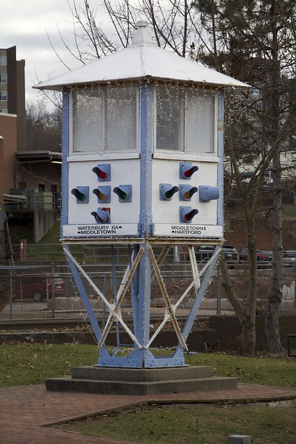
This blog focuses a lot on the broken, the rusty, the abandoned and the forgotten. But there is always room for the resurrected, the renovated, the repurposed and the refurbished. On January 14, 2016, Mick Melvin shared a nice story about a traffic control tower in Meriden, Connecticut. "Traffic Stop" taught me, and probably many readers, about an old-school traffic management system.

Untitled

(Traffic control tower in Meriden, CT.)

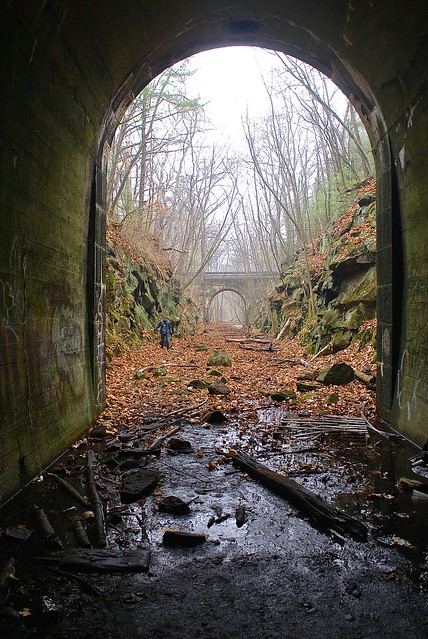
I love old mill towns, with their massive factory complexes, surplus of railroad tracks and bridges, practical homes and churches catering to immigrants. On January 27, 2016, I posted about the few hours I spent in Clinton, Massachusetts. In "Finding Hope, But Losing a Mainstay, in Clinton," I walked through an 1,100-foot, graffiti-covered former Central Mass. Railroad tunnel; snapped photos of ticket booths outside what locals claim is the oldest continuously used baseball field in the world; and captured the wonderful neon sign of a restaurant that closed not long after I visited the city.

Into the light

(Exiting the abandoned tunnel in Clinton, Mass.)

On February 4, 2016, I posted about an adventure in my hometown of Simsbury, Connecticut. With some family members, I explored the remnants of a once-thriving village along an old stagecoach route, a place I'd never heard of growing up. "Stealing Back Into the Past of My Hometown" features photos of old wells, cellar holes and stone walls.

In "Bunker Buster" from February 17, 2016, I chronicled one of the coolest places I've ever explored: the Assabet River National Wildlife Refuge. I've got two words for you: ammunition bunkers.

(World War II-era bunker at Assabet River National Wildlife Refuge.)

On February 23, 2016, in "A Slice of Heaven," Mick Melvin told the story of a park in Hartford that once featured b-ball courts and chess tables, and which now is called Heaven Skateboard Park.

On February 29, 2016, the blog took a leap into one of the most iconic Massachusetts suburbex locations: Medfield State Hospital. Courtesy of Derek Watts's "Shuttered Asylum," we got to see beautiful photos of the asylum, which was open from 1896-2003.

The year was front loaded with some great posts, including "Shakin' All Over," my account from March 5, 2016, about a former Shaker village in Harvard, Mass., and its unusual cemetery.

Wrapping up the first quarter of 2016 was "Big Walk in Littleton," one of several posts around this time in which I attempted to profile an entire town. In this March 30, 2016, post, I took on the former farming town of Littleton, Mass., and featured an old train station, an abandoned juice plant, a cool house built in 1673 and a chimney in the middle of the woods.

(Abandoned farm house in Littleton, Mass.)

The hit parade continued on April 7, 2016, with "Sweet and Junky," my chronicle of a visit to a chocolate factory cheek-by-jowl with a junkyard in Somerville, Mass.

In "No More Bell to Toll," from May 3, 2016, Kristen Smith shared gorgeous photos and the story behind the first Estonian Lutheran Church in the country, located in Wisconsin.

On May 7, 2016, in "Last Stop," Derek Watt shared some beautiful shots from a transportation graveyard in New England.

(Trains in the graveyard.)

We focus quite a bit on railroads here at the blog. I find it hard to believe how an industry that once was so vital and omnipresent across our country has become an afterthought in so many places. In "Station In Need of Preservation," from June 21, 2016, Mick Melvin told us about a train station in Windsor Locks, Conn., that may one day be preserved.

On July 19, 2016, I posted "Tobacco Road," about an adventure I enjoyed on many levels: I had my mother with me; I saw some cool old tobacco barns and a decrepit church; I did a bunch of research online and learned about this little plantation not far from where I grew up.

(Church in the Floydville section of East Granby, Conn.)

July 26, 2016, was a great day on the blog, as we featured Derek Watts's fantastic shots of the inside of the old Victory Theatre in Holyoke, Mass. In "V for Victory," he posted photos of the theater's interior, taken with permission.

My post from August 1, 2016, found me alternately paranoid and ecstatic to be walking along some long-abandoned railroad tracks. "I Rail Against Trails (Not Really, But I Don't Want Every Abandoned Set of Train Tracks Converted for Cyclists and Roller Bladers)" is not only the longest headline the blog has ever published, but also a fantastic adventure, with a side trip to a graffiti-covered snack truck.

As regular readers of this blog know, I have a thing for churches and religious icons, even though I'm not at all a spiritual guy. On September 16, 2016, in "Like a Virgin," I wrote about and posted photos of the amazing Madonna, Queen of the Universe Shrine in East Boston, Mass.

Every so often I get one or both of my kids to accompany me a on a Backside jaunt. In "Rockin' in the Dungeon" from October 21, 2016, I chronicled a trip the three of us took to Dungeon Rock in Lynn, Mass.

Water towers in New York City caught Mick Melvin's eye in his November 15, 2016, post, "Water You Talking About."

(NYC water tower.)

On December 22, 2016, Derek Watt shared gorgeous photos of a historic home under renovation in Hudson, New York.

(Door detail from Dr. Oliver Bronson House, Hudson, NY.)

We wrapped up the year with "What's Auers is Yours" on December 29, 2016. I'm highlighting this post because it features an adventure that somebody else took me on, which is rare. My buddy Gary and his family hosted my family and me as we walked through the historic Auerfarm property in Bloomfield, Conn.

(Window from old apple barn at Auerfarm.)

Here are the previous six installments in this anniversary series:

"Anniversary Post #6: My Favorites from 2015"

"Anniversary Post #5: My Favorites from 2014"

"Anniversary Post #4: My Favorites from 2013"

"Anniversary Post #3: My Favorites from 2012"

"Anniversary Post #2: My Favorites from 2011"

"Anniversary Post #1: My Favorites from 2010"

Walking in Witch City

From Dave Brigham: In most towns, if you walk around looking for signs of Halloween nearly seven weeks ahead of time, you may find a half-...