Thursday, December 29, 2016

What's Auers is Yours

From Dave Brigham:

I grew up just a few miles from the Auerfarm property in Bloomfield, Connecticut, but hadn't visited this historic site until this past Thanksgiving, at age 51.

Better late than early, to coin a phrase. Auerfarm was a working farm for 40 years, owned by Beatrice Fox Auerbach after her husband died in 1927, two years after buying the property, according to the web site for the 4-H Education Center at Auerfarm. Mrs. Auerbach was part of the Fox family that owned G. Fox & Co., a Hartford department store. In the 1930's she was the first female president of a large department store.

The farm was deeded to the 4-H in 1976. Over the past 40 years the farming organization has renovated and repaired buildings, torn down old buildings (although not all of them, as you'll see), raised livestock and crops and taught children and adults alike about agriculture.

My longtime friend, Gary, suggested a hike around Auerfarm the day after Thanksgiving. Our families have a tradition of getting together on that day to reconnect, as I live 90 minutes away outside Boston but always visit family in Connecticut for Turkey Day. I knew the property would have some cool photo ops, but had no idea just how many.

(The apple barn.)

There is an active orchard on the property, but this small barn hasn't seen a fresh apple in some time.

(Apple barn details.)

I take so many photos for this blog, but only a few of them really touch me, as they represent in so simple a fashion how easy it is for history to fade away. The photo below is one of them.

After hiking a bit, seeing the apple barn and doing a mannequin challenge with our families (a fun idea of Gary's), I figured that was about it. But we'd only been out a short time. Gary led us up an old road toward some buildings that he thought were probably summer homes of the Auerbach family years ago.

(From the front, this building looks like an average-sized house, but the four-bay garage turns it into something different altogether.)

With Christmas lights strung along the roof line, the old places didn't seem too far disconnected from the past. But obviously vandals have had their way with these places a bit.

(I found this sight funny, but also sad.)

The old log cabin was everybody's favorite haunt.

Peering inside, I found an odd mix of old furniture and newer toys.

The last house was the largest. With a scythe, a sturdy broom and some moxie it could be turned back into a decent getaway site.

After checking out the creepy buildings, we ventured over to the 4-H property and the kids had fun hanging out with the chickens, goats, donkey and rabbits.

Thursday, December 22, 2016

An Intimate Look at a Landmark

From Derek Watt:

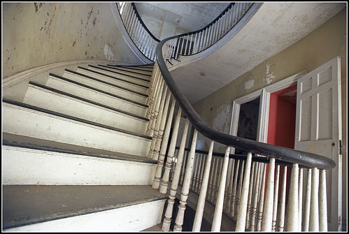
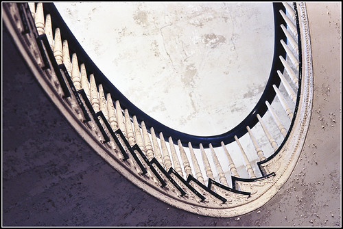
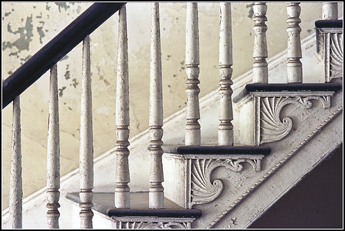
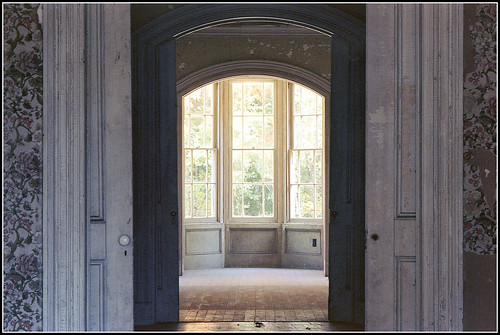
(Recently Derek Watt had a chance to explore and take photos of the Dr. Oliver Bronson House in Hudson, New York. Managed by Historic Hudson, the house was built in 1812, and remodeled in 1839 and 1849. To read more about this house, which was designated a National Historic Landmark in 2003 and has been under renovation for many years, read the Historic Hudson web site and Wikipedia page. -- DB)

Bronson 2016 02 Bronson 2016 04 Bronson 2016 05 Bronson 2016 09 Bronson 2016 10

Monday, December 12, 2016

Behind Bars

From Dave Brigham:

This foreboding building -- the prison at the Portsmouth Naval Shipyard in Kittery, Maine, -- has been closed for 42 years. Wouldn't you just love to get in there? Poke around the cells and look for dungeons and rats and skeletons and ghosts? Scare yourself silly in the middle of the night?

Few people not wearing black-and-white striped jumpsuits or naval uniforms have seen the inside of this place since it was completed in 1908. The prison looms over the Piscataqua River just across from the bustling hipster-town of Portsmouth, New Hampshire.

My family and I recently went on a harbor cruise, which took us past beautiful old homes and sentry-like lighthouses and run-down forts. But the prison is the most impressive feature of the cruise, in my mind.

In addition to Navy and Marine offenders, the prison played host over the years to German U-boat crews near the end of World War II, according to this article.

There has been talk of redeveloping the massive prison -- at the time of its opening it was the largest poured concrete building in the world -- into apartments or condos, to no avail.

For a closer look at the outside of the prison, check out these two videos:

Monday, December 5, 2016

I Seek Newton, Part VI: Chestnut Hill

From Dave Brigham:

(Bench in Houghton Garden, Chestnut Hill.)

Chestnut Hill is arguably the chicest of Newton's villages. Waban has loads of beautiful homes on large, wooded lots. In West Newton Hill, gorgeous Victorians abound. But Chestnut Hill -- which is comprised of parts of Brookline and Boston as well as Newton -- has enormous estates and old-money history, as well as a fairly good-sized backside.

When I think of Chestnut Hill, I think of captains of industry (New England Patriots owner Robert Kraft), old-money WASPs (at least one Saltonstall), professional athletes (Tom Brady) and other highfalutin types living behind high walls or gates. In my mind, they drive from their well-appointed homes in brand new BMW's or Teslas, directly into Boston for sumptuous meals at private clubs, or to a well-guarded helipad for a weekend on Nantucket. Their kids go to private school, and are named Teddy and Hampton and Tessa and Stella. They are mostly white, these people in my mind, as you can tell.

While I'm sure that Chestnut Hill is more diverse than I realize -- watching "Keeping Up with the Kardashians," shopping at Star Market and worrying about bullying and teen drug addiction and Donald Trump, like the rest of us -- there is definitely still an element of the "Essex Colony" that moved into the area back in the 1850's.

"In 1822, Joseph Lee came from Beverly and bought one hundred and sixty acres of the old Hammond Farm," according to Newton's 19th Century Architecture: Newton Centre, Oak Hill, Chestnut Hill, Commonwealth Avenue, issued by the Newton Historical Commission and the City Department of Planning and Development in 1985. When he died in the mid-1840's the land passed to his six nieces and nephews, who initially did little with the property. In the 1850's, however, "when Beacon Street and the railroad improved communication between Boston and Newton, several family members decided to settle there."

The family laid out roads and built houses, dubbing the new neighborhood Chestnut Hill. Among the families to settle in the newly constructed enclave were the Lees, the Saltonstalls, the Cabots and the Lowells, blue bloods through-and-through from Boston's North Shore (the name Essex Colony comes from Essex County in Massachusetts), according to the NHC/DPD booklet.

"The original Lee properties shown on the 1856 plan of 'Chestnut Hill' lay roughly between Beacon Street, Reservoir Avenue, Hammond Street and the railroad tracks," according to the booklet. "Some of the acreage lapped over into Brookline, accounting for that area of Brookline also called Chestnut Hill. As succeeding generations married, they were provided with house lots in Chestnut Hill and many of these houses remain, still lived in by descendants of the original families."

This document is 30 years old, but I'm sure there are still descendants of those families, and other original Chestnut Hillers, living there.

Despite a collective effort to maintain manicured lawns, employ a constant stream of renovation contractors and obtain privacy, Chestnut Hill has hidden elements that aren't really that hard to find.

Welcome to the sixth part of my series on the villages of my adopted hometown of Newton, Mass. For links to the previous five installments, and a tease about the next in the series, see the bottom of this post.

Chestnut Hill could just as easily have been named Hammondville. The family of Thomas Hammond Jr. were among the first white settlers in the area, in 1655. The village features Hammond Pond, Hammond Woods, Hammond Street and Hammond Pond Parkway. As stated above, the old Hammond Farm was carved up to become the heart of the early residential area of Chestnut Hill.

(Hammond House, the oldest in Newton.)

Known as the Hammond House, the property at 9 Old Orchard Road was built in 1714 by Thomas Hammond Jr., according to the National Register of Historic Places nomination, and is considered the oldest house in Newton. The house is currently on the market for just under $3 million; Coldwell Banker lists the house as being built "c.1645." I'm not sure what the correct date is, but I recommend clicking on the listing link to check out photos of this cool residence.

Just around the corner from the Hammond House is the Mary Baker Eddy Home.

(The backside of the Mary Baker Eddy Home.)

Founder of the Church of Christ, Scientist, Eddy lived in this house from 1907 until hear death at age 89 in 1910. She extensively remodeled the home, which was built in 1880, according to the Longyear Museum, which owns the home.

South of the Eddy home is the Webster Conservation Area, part of which was opened to the public in 1916 when the owner, Edwin Webster, gave 38 acres to the Commonwealth of Massachusetts, according to the Newton Conservators web site. In the ensuing decades Webster gave additional acreage, and the State took other portions of the land, as well as some Hammond land, by eminent domain for conservation, according to the Conservators.

This building was in the section of the conservation area known as the Deer Park. According to the Conservators web site, "Mrs. Webster brought a couple of dozen deer into the area many years ago." Many times over the last 15 years or so I spied deer on this property as I sped by on the busy Hammond Pond Parkway. I found it very cool to see wildlife frolicking in such a busy area. Alas, there are no more deer on the property, according to the Conservators. This building, which may have been part of a chicken farm at one point, was torn down recently.

Just steps away from where the shed/coop/barn once stood is Houghton Garden.

"From 1906 through 1940 Mr. and Mrs. Clement Houghton created a garden adjacent to their home at 152 Suffolk Road in Chestnut Hill," according to the web site for the Chestnut Hill Garden Club. "Mrs. Houghton served as the president of the American Rock Garden Society and her love of rock gardens resulted in one of the first of its kind. Their alpine rock garden is situated on a ledge overlooking Houghton Pond. It contains many dwarf conifers originally imported from the Orient by the Houghtons." The garden was listed on the National Register of Historic Places in 1999.

I've walked through this garden several times over the years. It's very peaceful despite the fact that it sits mere feet from the busy trolley tracks. Because of this proximity to the trains, my son loves going to this area.

I made my guess about the chicken farm because along the trolley tracks that separate the Deer Park from Hammond Pond conservation area, there is an official sign that says "Chicken Farm Truck Pad," where vehicles from the Massachusetts Bay Transit Authority (MBTA) can drive up to the tracks. There is also a pedestrian crossing here from the gardens to the pond.

(A rusty old rail cart sits next to the pedestrian crossing.)

The Hammond Pond area has some cool paths and rock walls where I've seen climbers testing their skills. On the other side of the Hammond Pond Parkway stands another section of the Webster Conservation area.

Signs urging the city to "Save Webster Woods" have sprung up since Boston College announced its purchase of Congregation Mishkan Tefila earlier this year. The college plans to use the former synagogue site for "parking and administrative uses," according to this Newton Tab article. But it is the 20+ acres of undeveloped land (i.e., Webster Woods) and B.C.'s potential use for that property that has many folks, including me, concerned.

(Half-submerged rock in small pond in Webster Woods.)

Worth saving, don't you think? Stay tuned...

Just a short distance away is a shopping area known as The Street.

(The Street outdoor shopping mall.)

The site along very busy Route 9 has been a retail destination since 1950, according to the official timeline on The Street's web site.

Above is the faded facade of the former AMC Theater, which opened in 1975 as a General Cinema. In the last few years, a new theater, Showcase Superlux, opened at the site.

Long before the retail development of this area, very different types of activities took place here. On an old map at the City of Newton web site, I spied something that said "Posse-Nissen School." It didn't take long to find out a bit more information online. The Posse-Nissen School of Physical Education specialized in Swedish Gymnastics, a system of calisthenics and exercises developed by Hartvig Nissen, a Swede who was director of the massage department at Boston City Hospital, and Nils Posse, a Swedish royal who moved to Boston in the late 19th century, according to Wikipedia and The Journal of Physical Education, Recreation and Dance.

At the eastern edge of the retail complex, just past the Star Market grocery store, sits an abandoned property hidden behind fences.

(A staircase that was once part of a home near the Star Market.)

Owned by the Chestnut Hill Shopping Center LLC, the land was sold to the developer by Eleanor Baldwin, according to documents I found online. In a cursory search online I found evidence that Ms. Baldwin was a Chestnut Hill resident for many years. I'd love to know what her old house on this property looked like.

Then there's the house that stands just a short distance away from The Street that has confused me for quite some time.

Listed on the Newton Assessors Database (one of my favorite online tools for research) as "developable land" owned by a trust, the property consists of this old shingled house and a small shed on just under 6.5 acres. I found nothing online for quite some time, but a few months ago I stumbled across information about architect William Ralph Emerson and houses he built in Chestnut Hill.

"The prominent architect William Ralph Emerson is known to have designed at least two houses in Chestnut Hill. Reusing an old barn, Emerson developed a striking Shingle style house for John Lowell which still stands at 517 Hammond Street." -- from a document published in 1985 by the Newton Historical Commission and the city's Department of Planning and Development.

But then I realized that 517 Hammond Street is next door to this property. Perhaps he also designed the long-abandoned house in the above photo. I need to visit Newton City Hall to find out more information.

The neighborhood just to the north of this neglected house, over the MBTA trolley tracks, is filled with stately mansions and beautiful churches. The lawns are green and constantly filled with contractors and landscapers running to and fro. Along Suffolk Road sits this reminder of times gone by.

(An old gate post, perhaps original to the neighborhood, stands on Suffolk Road.)

Back on Route 9, just a short distance west, once stood the Atrium Mall. Opened in 1989, the mall catered to the well-to-do of Chestnut Hill and surrounding areas. I used to like to take my kids there when they were young, because the mall had a playroom. But the high-end Atrium couldn't compete with downtown Boston shopping and the larger Natick Mall, located less than 10 miles away.

The parking garage under the mall was a cool place to spot sports cars and vintage vehicles under wraps.

Perhaps the cars' owners lived in some of the nearby high-rise apartment buildings that didn't have a lot of parking.

I took that photo a number of years ago. The mall closed four years ago and has been converted to an athletic center and medical offices

Just a short hop away from the old Atrium Mall, and across the street from the Mall at Chestnut Hill (and not far from The Street -- yes, Chestnut Hillers love to shop!) once stood an ugly strip mall/office complex/grocery store.

(The backside of the former Omni Foods grocery store, which was torn down a few years back to make room for the Chestnut Hill Square shopping area.)

A short jog down Route 9 and you're at Kennard Park on Dudley Road, the western edge of Chestnut Hill.

The City of Newton acquired the land in 1978 from Dr. Harrison Kennard, according to the Newton Conservators web site. This is a very pleasant, nicely wooded park, with old stone walls, lean-tos, remnants of an orchard, the old Kennard house, which serves as headquarters for the town parks and recreation department, and well-kept paths that eventually lead to a small pond over the town line in Brookline.

At the far eastern end of Chestnut Hill stands Boston College, which spills over into Boston's Brighton neighborhood. Across Beacon Street from the college's dorms, in a small patch of woods next to a dirt parking lot, stands this lovely statue.

The street abutting the statue is a dead end now, but used to go through.

Amidst the beautiful homes dotting the south side of Beacon Street as you wind eastward toward Boston sits this impressive pile.

The old gate house for the Chestnut Hill Reservoir across Beacon Street, this Romanesque building was erected in the late 1870's and controlled the flow of water from both the Cochituate and Sudbury aqueducts, according to Wikipedia.

Not far from the Chestnut Hill Reservoir sits the Waban Hill Reservoir.

(Waban Hill Reservoir and gate house.)

The City of Newton began construction on this reservoir in 1875, as part of its effort to supply all of its 13 villages with water. The water was drawn from the Charles River, near the Needham line, and pumped by coal-fired steam engines through the mains and across the city, according to Historic Newton's "Waban Hill Reservoir History."

I've explored the area near the location of the former pumping station on Needham Street (see November 20, 2011, "History Flows On, Part II," and December 6, 2011, "History Flows On, Part III").

Newton sold the reservoir to the Boston Metropolitan Water Board in 1900, according to the Newton Conservators web site. In 1891, the City of Newton completed construction of the reservoir's replacement, a covered, 10-million gallon structure just up the hill.

Across Commonwealth Avenue from the old reservoir sits this funky building with a cool roof.

Currently home to a fitness studio and a custom fabric and design shop, this place was built in 1920 and was used from 1925-1972 as a pharmacy and grocery store, according to property documents on file with the City of Newton. In ensuing years the building served as a real estate office and an insurance agency.

And thus completes my survey of Newton's Chestnut Hill village. As with all of the installments in this series, I could have dug more into Chestnut Hill. I plan to do so in the future, in the hopes of writing a book covering all of Newton's 13 villages.

Here are links to the previous five installments, ordered from most recent:

September 26, 2016, "I Seek Newton, Part V: Oak Hill"

June 3, 2016, "I Seek Newton, Part IV: Waban"

March 23, 2016, "I Seek Newton, Part III: Highlands"

September 20, 2015, "I Seek Newton, Part II: Auburndale"

May 21, 2015, "I Seek Newton, Part I: Lower Falls"

I'm not sure which village will be next. There are seven more, some more involved than others. Most likely I'll report on Thompsonville, the smallest and least commercialized village.

Monday, November 21, 2016

The Buildings That Time Forgot

From Dave Brigham:

I haven't posted as much about the backside of downtown Boston as I could have over the years. Usually when I'm in the city it's on a subway trip with my son, Owen, and I have limited time to seek out the abandoned, forgotten and dilapidated. For a list of posts about the Hub, see the end of this post.

Recently, however, I was on the city's wonderful Rose Kennedy Greenway with Owen and a few of his friends, and was able to snap pictures of two old buildings, one that's in a tight squeeze, and one that's been knocked to its knees.

Built in 1899, this four-story Financial District building has an electricity substation right next door. I remember walking past this place 20 years ago when I worked in the area, and marveling at how out of place it looked even then. Now, with skyscrapers rising downtown and in the Seaport District, this place is even more of an anachronism.

To see what it looked like when I was a younger man, read this 2007 article (which is truncated unless you're a subscriber) and look at the photo, which indicates a hardware store closed in 2006 when the owner died.

The current owner of the building set a selling price of $16 million four years ago, according to a 2012 Boston Business Journal article. That mark represented more than 28 times what the owner paid just a year prior, the article indicated. To be sure, real estate in this area, close to the Greenway, the harbor and the Seaport District, has shot up in value in recent years. But what can you do with this building or its footprint?

I couldn't find any news or real estate updates about the place. Maybe a pencil tower will rise here one day.

This is the other building I photographed, which I also recall from my days working downtown. While the hardware store surely has some good memories tied up in it, and certainly once fit more seamlessly into its neighborhood, there's no doubt that the building above, on Broad Street, was an important part of this area.

Most recently this building and the one next to it were home to The Littlest Bar and The Times Irish Pub & Restaurant. I never went to either, although I did go to The Littlest Bar in its original location in Downtown Crossing many years ago. The Times is moving to 99 Broad Street, not too far from another well-known bar, Mr. Dooley's. The Littlest Bar may move to a new location, although that announcement hasn't been made.

Built in 1805 and located hard by the Greenway, the Bulfinch building was originally a warehouse for goods coming off nearby wharves (back before the city installed fill to make itself bigger), according to this Boston Globe article, which you should read. According to the article, the outside of the building was declared a landmark, but the interior wasn't, because it had been changed significantly over the years.

After negotiating with the city's Landmarks Commission, the developer, New Boston Ventures, agreed to keep the portion of the building that you see above, and to incorporate it into a 12-story condo development (read the Globe article to see an artist's rendering of the new building married to the old structure).

Boston used to be known for cool bars in old brick buildings, and there certainly are some of those left. But it's a new millennium and the city is thriving and growing and glass and metal are of course the favored mediums. I'm glad the Landmarks Commission made the developer keep at least a part of the city's history intact, but it will be nothing more than a mere curiosity for residents, visitors and tourists unaware of the building's importance to Boston's past.

As promised, here's a list of other downtown Boston posts from over the years:

August 30, 2010, "Going Underground," about a trip on the subway with my son.

January 25, 2014, "Last Building Standing," about a remnant of the old West End.

August 19, 2015, "Misfit Garage," about a municipal garage slated to be torn down soon and replaced with yet another high-rise condo building.

October 19, 2012, "Window Dressing," about the former Dainty Dot Hosiery building.

February 10, 2011, "Up From the Basement?," about the long-empty hole where Filene's Basement once stood, and which is now a high-rise.

Tuesday, November 15, 2016

Water You Talking About

From Mick Melvin:

Untitled

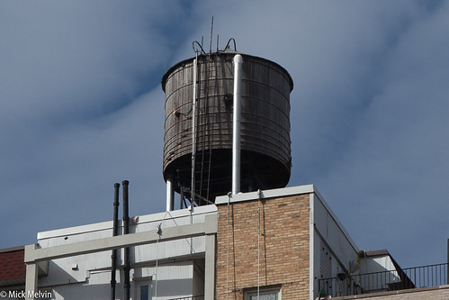
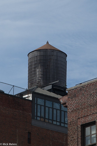
I was surprised by the amount of wooden water towers that dot the skyline of New York City. I was recently on the Upper West Side visiting friends and noticed these old-looking water towers.

Every direction that I looked I could see water towers. Most of the towers are plain wood, but some have a little writing on them. I did a little research and found out that these water towers last for 30 years and most of the towers are built by two companies. When you are in NYC, look up and I’m sure you will see these timeless icons.

Untitled

To learn more about water towers, check out this AM New York article.

Wednesday, November 9, 2016

Brigham in Waltham, Part I

From Dave Brigham:

I've written about two dozen posts here over the years about, at least in part, Waltham, Mass. (check out these search results). Just next door from my adopted hometown of Newton, Waltham is a former mill city of just over 63,000 residents. Known as the Watch City, Waltham was home to the Waltham Watch Company, the first company to make watches on an assembly line. The city was also home to textile factories in the 19th century. There are plenty of old buildings downtown, in addition to former factory worker housing, churches, old and current railroad tracks and related facilities, diners and plenty of other sites that we here on the Backside love to check out.

Just as when the mills were humming thanks to immigrant workers, Waltham is still a city that welcomes those from other lands. As of the 2010 census, nearly a quarter of the city's residents were foreign-born, many from India and Guatemala, according to Wikipedia. I can tell you from casual observation that six years later, that percentage has surely risen.

This is the first of a three-part series about the city. You will see a few dozen photos and learn about abandoned buildings and repurposed structures alike. You will gain knowledge about classic churches and long-neglected railroad right-of-ways, as well as see ghost signs and out-of-the-way monuments and murals.

As with other town and city surveys I've conducted (see list at the bottom of this post), this post is by no means an exhaustive tally of all of the cool and historical aspects of Waltham.

OK, let's get started.

According to the Waltham Land Trust, this little building holds electrical controls for Waltham Common, the park behind city hall bounded by Main, Moody, Carter and Elm streets. I love how it's styled like a classic New England church, with white clapboard siding and a steeple.

Just to the left of this quaint building sits a memorial to a man who had no connection whatsoever to Waltham or, for that matter, Massachusetts. Dag Hammarskjöld was a Swedish diplomat and the second secretary-general of the United Nations, serving in that role from April 1953 until his death in a plane crash in September 1961, according to Wikipedia.

Just a month after Hammarskjöld's death, the Waltham Junior Chamber of Commerce installed this plaque. Although the diplomat had no ties to the Watch City, the CofC members obviously felt it necessary to honor the man who had sought to bring peace to the world for eight years. He was en route to Congo to negotiate a cease fire when his plane crashed under mysterious circumstances, according to Wikipedia.

Turn east from the little house and the Dag plaque and you'll see this Queen Anne-style building, which is stunning now even its decline.

Built in 1880, this building was once known as the Elm Street Music Hall. The theater's occupancy was more than 1,000 people, and they saw speakers including Mark Twain, Oliver Wendell Holmes and Ward Beecher, according to this article, which is about the building owner's plan to restore the facade. The theater burned down in 1932 after hosting music and vaudeville performances, as well as movies, leaving the facade, which houses retail stores on the first floor and apartments above.

When I checked it out recently, there was work being done on the roof, so I believe the restoration mentioned in the article is under way. Can't wait to see what it looks like when the project is completed.

We skip now just a short distance to the place known by my wife and her family as the Superdome church. Or is it the UFO church?

Dedicated in 1964, Sacred Heart Church is unlike any church I've seen. "The style was not to be bound by popular tradition, not to be merely modern - it was to be a glimpse into the future," according to the church's web site. I was in the wedding of my good friends Jim and Nikki here several years ago.

We're looking here at, of course, the backside of the church, which is the second structure to stand on this property. The original church, built in 1924 for a largely Italian immigrant parish, now houses CCD classrooms and the church hall.

About a half mile away is an imposing brick mastodon of a building, St. Charles Borromeo Catholic Church. Built in 1922, technically the building is an example of Italian Renaissance Revival architecture.

(By User:Magicpiano, Wikimedia)

Listed since 1989 on the National Register of Historic Places, the church has no steeple or stained glass windows, but it has one architectural feature that caught my eye.

At Main Street's Christ Church Episcopal, which opened in 1898 and is also on the National Register, I saw this proud, yet forlorn, detail.

Waltham is filled with congregations, including one whose church has an interesting past.

Ministerio Evangelico Rios de Agua Viva (Evangelical Ministry Rivers of Living Water) is located in the former Hamblin L. Hovey Memorial Building. Outfitted with a 1,300-seat auditorium when it was constructed in 1935, the Hovey building had a fully functional stage and an orchestra area that could accommodate 500 seats, according to the web site for Hovey Players community theater group, which at its inception performed in the building. In 1952, the International Brotherhood of Electrical Workers bought the building. In 1998 a Buddhist group, SGI International, acquired the building and walled off the balcony while converting the auditorium to a temple, according to the Hovey Players web site.

I'm not sure whether SGI still owns the building.

Across the street from the Hovey/church building sits the Jonas Willis Parmenter Home.

This building in and of itself is nothing all that interesting, but history doesn't always come in beautifully decaying packages or awe-inspiring architecture. History is each and every person living their lives, making decisions, going to work, honoring their loved ones. Parmenter was a coal, wood and brick dealer, according to the Hovey Players web site. He was also the father-in-law and employer of Hamblin Hovey, namesake of the memorial building talked about above.

In 1889 Hovey built the Parmenter Block not too far from the site of the Hovey Memorial Building and the Parmenter Home. Named in honor of his father-in-law, the building had retail space on the ground floor and an auditorium and banquet hall on the two floors above, according to Melissa Mannon's "Images of America: Waltham," from Acadia Publishing, excerpts of which I found via Google Books.

Hovey died suddenly in 1904, according to the Players web site. In 1935, the Parmenter family commissioned several buildings, two of which were named in Hovey's memory: the memorial building and a dance hall that's been gone for some time. This is the kind of stuff I find increasingly fascinating, the forgotten history of cities and towns, the people behind named buildings, the citizens who built a place and left behind legacies that benefit future generations.

Every city and town has hidden history, of course, but in old mill towns like Waltham it's easier to find. One day, driving through the city on a route I had done dozen of times, I just happened to look to my left and see this place, as if for the first time.

What caught my eye was the sign across the front of the porch: Gilbrae Inn. I knew there was no way this was an active hotel, so I took to the Internet. Listed on the National Register of Historic Places, the inn was built by the Boston Manufacturing Company, which built the world's first spinning and weaving factory in Waltham. The inn was a rooming house for BMC employees, and was built sometime between 1827 and 1854, according to Wikipedia (not sure why a specific date is so hard to pin down). It is the only surviving boarding house built by the company, according to Wikipedia.

I've located one other 19th century building that took in guests.

Known as the Prospect House, this former hotel and tavern is now an apartment house, according to Wikipedia. Built in 1839, it too is on the National Register.

The penultimate stop on this first part of a three-part installation is a cozy little social club. Maybe they'll invite us in for a drink....

Founded in 1886, the Piety Corner Club is Waltham's oldest neighborhood association, according to Waltham-Community.com. The neighborhood is so named because it was home to several ministers at some point, most likely in the 19th century.

Finally, a rather new-looking sign commemorating a historic event.

Located at the corner of Route 20/Weston Street and the very short Tavern Road, this marker speaks of an event I've written about before, Gen. George Washington's march from Virginia (I think) to Cambridge, Mass. (see April 20, 2016, "Washington Walked Here"). Research online didn't bear any fruit, but I'm guessing there was a tavern near this location and maybe the good general popped in for a quaff or two.

In the next two installments of this series, I will cover railroad, diner and oddball house/retail stuff, as well as ghost signs, murals and a few other things.

As I mentioned at the top, I've also written and taken photos covering other towns in eastern Massachusetts:

December 9, 2015, "Scenes From an Old Shoe Town," about Hudson, Mass.

January 27, 2016, "Finding Hope, But Losing a Mainstay, in Clinton," about Clinton, Mass.

March 30, 2016, "Big Walk in Littleton," about Littleton, Mass.

A Peep at Greenwich Village

From Dave Brigham: Near the end of August I drove to New York City with my daughter and one of her friends. They wanted to check out New Y...