Friday, September 28, 2018

Rhymes With Radio Snack*

From Dave Brigham:

This is the back of a rather nondescript building on the campus of Boston University. In the foreground is the Massachusetts Turnpike. The building, located at 730 Commonwealth Avenue, is often referred to as the Radio Shack building, as it was, until last year, the location of a store in that storied electronics chain that held special significance. The company opened its first store in 1921 on Brattle Street in Boston, according to this article. As the company grew, it opened its first headquarters in this location. Now, all that is left of that legacy is the very faint ghost sign you can see here.

*The headline for this post references a joke I heard many years ago. I don't recall who gets the credit, but the set-up was something along the lines of, I can't say the name of the store, and the punch line was, "But it rhymes with Radio Snack."

Saturday, September 22, 2018

Modern-Day Monastery, No Celibacy Required

From Dave Brigham:

Sometimes I think I should subtitle this blog "Serendipitous Travels Through History." I keep two running lists of places to explore, one each on my phone and laptop. I may never get to everything on those lists, but that's OK. Often when I check out one place on a list, I find at least one additional site to dig around in. That's what happened on a recent visit to Boston's Brighton neighborhood.

I put the Our Lady of Fatima Shrine on my list a while back because a) I have an atheist's curiosity about religious icons and b) I'd read that there was development planned in the area and I wanted to take some pictures before that happened. I will write about the shrine in a future post. On that excursion, I also knocked off a few other places I'd put on my list: the apartment on Commonwealth Avenue where the members of Aerosmith once lived (see July 17, 2018, "Livin' On the Edge"); a former military post being converted to veteran housing (see August 3, 2018, "Marine Barracks to Be Saved"); and Brighton Center (see July 23, 2018, "Shining a Light On Brighton Center"). After snapping pictures of the first two spots, I took an unplanned detour on Warren Street, which is around the corner from the military site.

I didn't see anything I wanted to shoot as I approached Brighton High School. That's when I noticed a sign for Monastery Path. I knew this would lead me to the shrine site, and decided "What the heck?" and up I climbed the gently rising sidewalk.

Here's what awaited me at the top of the hill:

This is the former St. Gabriel's Monastery. Opened in 1911, this Mission Revival complex is impressive.

I had no idea this old monk residence, with its cemetery for residents and massive church, was here. I also had no idea it has been abandoned for quite some time (since 2006). What I figured out quickly enough was that the redevelopment I'd read about that I thought related to the shrine, was actually about the old monastery, which was designated a Boston landmark nearly 30 years ago. The shrine, as you'll see in a future post, is on the grounds. According to a Boston Herald article, the shrine would be moved to a new building when the monastery project commences.

Now, about that construction. The Boston Planning & Development Agency last November approved plans from developer Cabot Cabot & Forbes to redevelop this almost 12-acre site. CC&F will build four new buildings with 660 apartments and condos on the site. The developer will also restore the monastery for housing, and the church for a community center, according to this article, which includes artist renderings of the future development. Many of the stained glass windows will be kept.

Here's a video showing the current state of the property, as well as the planned development:

On the hill sloping south of the monastery, near the shrine, sits a small cemetery, which holds the remains of the priests who lived there over the course of decades.

While CC&F mentions in the above video that it plans to "spruce up" the park in front of the monastery. I can't imagine that would entail moving the gravestones. The cross? Maybe.

I will return here at some point to document the new neighborhood that will spring up in the coming months and years.

Sunday, September 16, 2018

Living Behind a Ghost Sign

From Dave Brigham:

I see you, ghost sign!

On a recent walkabout in Porter Square in Cambridge, Mass., I spotted this old painted advertisement. As you know, this kind of thing makes me happy. I continued along Upland Road, hung a right on Richdale Avenue, and saw even more.

Built in the 1890's, the former University Storage building is part of a condo complex that was developed in the 1980's. That is all.

Monday, September 10, 2018

A Boneyard Within a Cemetery

From the Crypt Keeper:

I should set up a tip line for the blog. And build an army of drones and cyborgs to venture into the field to take pictures and go online to do research. And hire a team of monkeys to write it all up. This is brilliant.

Until I do that, however, I will rely on my own digging and snooping and the occasional suggestion from friends and family. Such as my buddy Jeff, who mentioned to me quite some time ago that I should check out a "cemetery within a cemetery" in Medford, Mass. I finally did, along with my son, Owen, and we found a pretty cool place.

The Cross Street Cemetery was established in 1816 and all was going well, or as well as things go in a large plot of land filled with the dead, until the 1950's. That's when the State of Massachusetts, or perhaps it was the federal government, began ripping the area apart in order to build Interstate 93. Fortunately, according to this article, space was found in the nearby Oak Grove Cemetery, and the gravestones (not sure whether it was all of them) were moved behind their own stone walls within the larger graveyard.

Pretty cool, eh? If you've got a lead on an interesting site on the backside of America, let us know. Send an email to this here address.

Wednesday, September 5, 2018

With Kenmore Square Development, Citgo Sign Will Stay

From Dave Brigham:

I've lived in the Boston area for nearly 30 years and have seen a lot of changes in the cityscape, especially in the past decade. There's the Hub's Seaport district, which went from an artist district with loads of muddy parking lots, to a glitzy neighborhood filled with high-tech companies, museums, law firms and high-end condos and restaurants (see February 1, 2017, "Bon Voyage, Lady"). And Kendall Square in Cambridge, which went from a bit of a sleepy tech outpost to being lousy with bio-tech firms, funky eateries and high-end condos and restaurants. And Kenmore Square, former home of punk hangout The Rat, dance club Narcissus and mom and pop restaurants, and now increasingly a place for the well-to-do, with the Hotel Commonwealth, Eastern Standard restaurant and, soon, a major office development underneath and abutting the building where the famed Citgo sign shines.

"Developer Related Beal has filed detailed plans with the Boston Planning & Development Agency that would add two new buildings to Kenmore Square - one of which Boston’s most famous sign would bestride," according to a Curbed Boston article. "The plans include incorporating 660 Beacon Street, which has been holding up the famed 60-foot-by-60-foot Citgo sign since 1965, into one of the new buildings.

"The prolific Related Beal bought 660 Beacon and several other buildings in the area in 2016, touching off speculation that the sign was doomed. Organized opposition to its demolition arose even before the sale, when former owner Boston University announced it was putting the buildings on the block. Related Beal and the oil concern behind the sign struck a deal in March 2017 intended to keep the clarion beaming for decades. And it will likely do so from atop a major office development, as the recently filed details make plain," according to Curbed Boston.

So I strolled by these buildings recently to see what will be torn down and/or changed drastically.

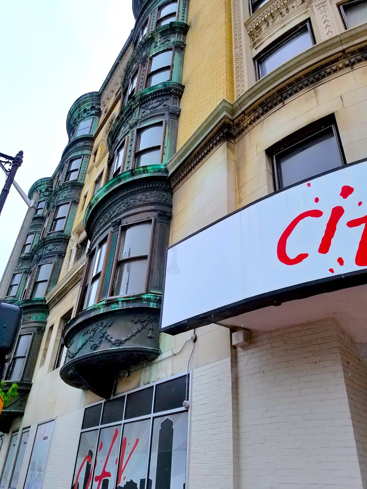
The building at the corner of Commonwealth Avenue and Deerfield Street -- known as West Gate -- was most recently home to City Convenience and, presumably, several apartments. Just look at those gorgeous projecting window bays on this building, which dates to the late 19th century. There are lots of buildings that look like this in Boston, so in some sense it's a dime-a-dozen situation. But with each one that gets torn down, which this one eventually will, Boston loses a bit of its history.

West Gate was evidently in declining health for some time. A Boston Globe article from November 2015 about the death of a homeless guy named Melvin who was a fixture in Kenmore Square, refers to the West Gate as "derelict." To see great old photos and learn the history of Kenmore Square, check this out.

The Citgo sign -- erected in 1965, replacing a similar sign from 1940 -- is a landmark unlike any other in Boston. You see it looming in the distance during Red Sox broadcasts, and people use it to orient themselves toward Kenmore Square. There's no way the good people of Boston would have allowed the sign to be torn down. In the above photo it looks down on the former site of a Bertucci's restaurant, which is also where the infamous Narcissus club was located.

(The side of the former Bertucci's/Narcissus building, which is slated to be torn down.)

While the building that houses Kenmore institution Cornwall's will be torn down, the restaurant owners maintain that they will reopen in the new building after construction is completed, according to this article. Other buildings in this block will also be torn down; it's unclear whether Bruegger's Bagels, the Barnes & Noble book store and other businesses will return to the new development.

Amid the changes in Kenmore Square, there is at least one holdout, albeit a mysterious one (see February 8, 2018, "Casual Abandonment").

Friday, August 31, 2018

A Ghost of Boston Past

From Dave Brigham:

Ghost signs are fairly prevalent in older cities, including Boston, where I spend a fair amount of time roaming around with my son, Owen. Ghost buildings are out there, too, but I don't see them all that often. The one above is on West Street in what is known as the Ladder District. This vacant lot sits between two restaurants: Fajitas & Ritas and Papagayo. A company called American Meter Company once occupied a building on this spot. For more about the history of this neighborhood, read this Boston Landmarks Commission Study Report about 13-15 West Street, the address where Papagayo is now. Built sometime between 1814 and 1820, 13-15 West Street was once home to a bookstore, library and school operated by Elizabeth Palmer Peabody, a well-known educator and prominent figure in the Transcendental Movement. The study report contains a photo of American Meter (scroll down to page 10).

Sunday, August 26, 2018

You Have Been Un-Matriculated

From Dave Brigham, B.A., Journalism, Keene State College, 1987:

I've stumbled across all sorts of things over the course of 8+ years of exploring the backside of America -- an old gas pump in front of a cemetery monument company (see November 30, 2017, "Stone Cold Monuments)," a jalopy in the woods and the story of a notorious Colonial-era highwayman (see April 30, 2016, "The Tavern of Death)," and old pump houses in the woods (see November 20, 2011, "History Flows On, Part II)".

I can now add an abandoned college campus to that list.

Atlantic Union College was founded in Lancaster, Mass., in 1882, and was the oldest campus in the Seventh-day Adventist worldwide educational system, according to the school's web site. "It served the Northern New England Conference, New York Conference, Southern New England Conference, Bermuda Conference, Greater New York Conference, and Northeastern Conference," according to the history of the school posted on the web site.

The school announced in February that it would close, due to the loss of its subsidy from the Southern New England Conference, according to this Telegram & Gazette article. "Atlantic Union has formed articulation agreements with Southwestern Adventist University and Andrews University for that purpose," school spokesman Emmanuel Ortiz told the newspaper. "The college claims students won’t lose their credits if they enroll at either school," the article continues. The school reopened in 2015 after being shuttered for four years due to financial difficulties.

The school's web site now offers information to former students about how to obtain transcripts.

I knew none of this before visiting Lancaster for the first time recently. I had some time to kill while my son was at school taking part in a driver's ed program (in the near future I will post photos and background information about other things I found on my trip). I was aware, from doing a little research, that the college existed. I didn't plan, however, on visiting the campus. I wanted to check out Founder's Hall, which I learned about through some quick online research.

Magnificent, isn't it? Built in 1883, it was listed on the National Register of Historic Places in 1980. Somehow in my research I missed the fact that the hall is located on Atlantic Union's campus. So I drove up a short driveway and parked in a lot in front of the gorgeous building. After snapping a few pictures I looked around and realized that I was on campus....and that there wasn't a soul around. Sure, it was early June and I figured school was out for the summer. But college campuses always have some folks hanging around, either for summer classes or doing maintenance work or whatever.

So what will become of the campus? Since this is the second time it has closed in the last decade, I suspect it won't reopen as Atlantic Union. Perhaps, as happened in my adopted hometown of Newton, Mass., a larger college will swoop in, as UMass Amherst did with the struggling Mount Ida College.

Stay tuned....

Thursday, August 16, 2018

The Lowdown on the High-Speed Line

From Dave Brigham:

Most folks in Greater Boston are likely at least somewhat familiar with the MBTA's four subway/trolley lines -- the Blue, Green, Orange and Red lines -- regardless of whether they ride them or not. How many people in the metropolitan area, however, know about the Ashmont-Mattapan High Speed Line, unless they ride it everyday or are train lovers?

Regular readers of this blog know that my son, Owen, and I often ride the subway in and around Boston. We've been doing this for more than 10 years, as what once used to be a special occasion has turned into something we do most weekends. We do many of the same things on our trips, from eating pizza at Regina Pizzeria at South Station to riding mainly on the Green line, but we seek out new areas of the city fairly frequently, so I can take pictures of things to write about here.

In the last decade we have taken a handful of rides on the Ashmont-Mattapan line, and it's always a pleasure (regular riders may beg to differ with me, as I know the line, like all MBTA branches, has its issues). A little background: the line is an extension of the Red line, which terminates at Ashmont Station in Boston's Dorchester neighborhood. The loop at Ashmont looks like this:

"Those cars aren't red," you're saying to yourself. That's correct. These cars, known as PCC streetcars, date to around 1945, according to my in-house MBTA expert, and were at one time painted green, before being restored "to their original Boston Elevated Railway paint that they were originally delivered in," according to this article at the Boston Streetcars web site.

The Ashmont-Mattapan line exists along what was formerly the New York, New Haven & Hartford Railroad. The other end of the line is in Boston's Mattapan neighborhood, but the middle section runs in part through the town of Milton, as well as Cedar Grove Cemetery. The line as we know it today opened in 1929.

In addition to the cool old train cars, the line also features an old station.

I'm not sure when Mattapan Station was built, but I believe it was the mid-1920's. Check out this photo and also this one, each of which date to 1924.

"So what's in the station now?" you ask. When I took this photo a few months ago a place called Kuizinn Lakay Plus, which offers pizza and also CD's and DVD's, per the sign. I believe "Kuizin Lakay" is Czech for "Food & Discs."

The cozy place next door is a Spanish restaurant, RestauranChito, that I believe is still in business. It was hard to tell. I'm guessing this place has been around for a long time as different hole-in-the-wall eateries, but not as long as the old station.

Thursday, August 9, 2018

Backside, Out In the Open

From Dave Brigham:

I'm so used to the solo pursuit of shooting abandoned railroad tracks, historic buildings and cool neon signs that it just seems weird to take pictures of these things I enjoy so much, alongside members of the general public who normally don't pay them much mind.

But thanks to a summer-long display at Boston's Rose Kennedy Greenway, seekers of the backside of America, and those who just happen to be strolling along this beautiful space near the city's waterfront, can enjoy eight vintage neon signs from the collection of Dave Waller, a local businessman.

I interviewed Waller several years ago for a publication put out by the Society for Commercial Archeology. I chatted with him in his home, a converted firehouse, and took pictures of many of the signs in his collection. I posted a few photos way back when on this blog: March 22, 2010, "Gettin' My Kicks."

I highly recommend checking out the signs this summer.

Friday, August 3, 2018

Marine Barracks to Be Saved

From Dave Brigham:

This photo of a former Marine officer barracks in Brighton, Mass., isn't great, but the building itself, along with one other on the site at the corner of Commonwealth Avenue and Warren Street, will serve a good purpose: to house low- and middle-income military veterans.

The Brighton Marine Health Center is now part of St. Elizabeth's Hospital, but I assume it was run by the military at some point. I believe the buildings on site date to World War II.

The health center established a partnership with WinnCompanies several years ago to build apartments for vets. After gaining approval from the Boston Redevelopment Authority, the project hit a snag when Massachusetts Secretary of State William Galvin objected to the plan to tear down all four barracks, in his role as head of the state's historic commission. Long story, short: everybody involved arrived at a compromise of keeping two of the barracks, which once housed officers and doctors (since I took these photos, the other two barracks have been torn down). Nice to see these buildings which, while they aren't historically significant, are solid reminders of the Greatest Generation, will be saved.

For a peek at what the finished development will look like, go here.

Saturday, July 28, 2018

A Sign of Hope?

From Dave Brigham:

I have passed by the North American Indian Center of Boston many times in recent years, on subway trips with my son. For nearly 50 years, the center has "provided cultural, social, educational, and professional related services to the New England Native American* community," according to its web site. Recently, I noticed the group's sign had been removed from its headquarters on South Huntington Avenue in Jamaica Plain, and that the building looked a bit roughshod.

I worried that, like other older buildings in the neighborhood, the NAIC would fall to the wrecking ball in favor of a boutique hotel or an all-inclusive apartment complex. The nearby lot where I shot the photo for "Matt Foley's Van?" on October 2, 2015, was developed last year into the Walter Huntington Apartments.

Well, I'm happy to report that the Indian Center has a new sign (covering a window), so I assume the place is still in business. I imagine, though, that this site will be sold before too long, as so many other lots like this across Boston have been in the last decade.

Scrambling Through Boston's Egleston Square

From Dave Brigham: I've danced around Boston's Egleston Square quite a bit over the years I've been publishing this blog. I...