Friday, October 27, 2017

Set Yourself Free on Prison Point

From Dave Brigham:

When I'm walking along, minding my own business, and spy a building that says "Prison Point Pumping Station" on it, you know I don't have a choice but to take a boring picture of it and commit myself to finding out the story.

On one of my regular trips along Boston's subway system with my son, I requested of him that we check out the Lynch Family Skatepark. Located under an Interstate 93 offramp in the easternmost section of Cambridge, the skatepark opened last November after years in planning and development, and has become quite popular.

Check out the Creating Skate Space video from Leslie Tuttle to learn how the park came to be, hear from the people who sculpted it out of a former wasteland, and listen and watch as the young'uns who use it describe what it means to them.

After watching the skaters for a few minutes, we turned to walk toward Lechmere MBTA station to continue our journey. Just a few steps from the skate park we saw the Massachusetts Water Resources Authority pumping station, pictured above, behind a chain-link fence. It's not much to look at, but that name.

Why is this area called Prison Point?

Let's take a quick look at the larger area where Cambridge meets Boston down by the river Charles, shall we? Many of you are likely familiar with Boston's Museum of Science. Directly across the busy four-lane road from the museum sits the Lechmere viaduct, on which MBTA Green line trolleys run. Under the viaduct the Charles River is squeezed through a lock before opening up a bit on its way toward Boston's Charlestown neighborhood and on to Boston Harbor. If you were drifting by on a boat and looked to your left, you'd see North Point Park, a lush area popular with sun worshippers, dog walkers and the baby stroller crowd. The park in its former life was an industrial dumping ground and staging area for the construction of the massive Big Dig highway project. Moving a bit more northeast, you find yourself at Boston Sand & Gravel, which, like the above-mentioned skate park, sits under highway ramps. Finally, another quick jaunt to the northeast, under Interstate 93, and you're at Bunker Hill Community College, situated on the former site of -- wait for it -- Charlestown State Prison.

Opened in 1805, the prison was in operation for a century and a half. This area of Charlestown/Cambridge was filled in long ago, but when the prison was built the Charles River flowed right on by. Eventually railroad tracks, industry and housing were sighted nearby. The prison closed in 1955 and inmates were moved to a new big house in Walpole. By 1973 the imposing brick institution had been razed, replaced by the community college.

Check out this blog post from And This Is Good Old Boston for prints, maps, photos and history of the hoosegow.

I plan to return to the skate park, as it's fun watching people perform stunts I could never dream of doing. I also want to walk across the North Bank pedestrian bridge that connects North Point Park to Paul Revere Park in Charlestown.

I've enjoyed watching the evolution of this whole area of Greater Boston. In the coming years, plans call for the development of what is called NorthPoint, a 45-acre site that could eventually feature 5.2 million square feet of commercial, residential, hotel and mixed-use development. Some buildings have already been completed. I will surely keep an eye on this.

Friday, October 20, 2017

Dead Reckoning

From Dave Brigham:

Ah, the dead! They let us walk over their heads and stumble on their crumbling architecture. They tolerate us rubbing their headstones and pondering their out-of-fashion names. They know that we only come out during the day; the night belongs to them.

To get myself ready for Halloween, I recently bothered the good folks at the Old & New North Cemetery in Sudbury, Mass. Here's what I found.

The first fellow I ran into was Abel Hunt.

I love the Biblical names you find in old New England boneyards. Abel, of course, was the good son of Adam and Eve. Slain by his brother, Cain, Abel nonetheless has won out in the end, as his name (which means "breath" in Hebrew) was the 137th most popular on some random baby name list I found online, as opposed to Cain (meaning: "possessed"), which ranked 750th. Take that, evil brother!

Abel's relative, Asahel, got a much cooler tombstone, but, man, that name had to be tough to live with. Yes, it's pronounced just the way you think it is. Don't stifle your chuckle. Just let it out. Anyway, Asahel is another name from Biblical times. And, alas, like Abel, Asahel was slain. His death dealer was Abner. No, not this guy. This guy.

The name Mehitable is brought to you by the Old Testament. A girl's name, it means "God rejoices," according to the Bible of online information, Wikipedia.

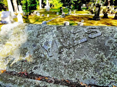
Haynes Road intersects with the road that the Old & New North Cemetery sits on. You'd think, therefore, that the family might have some pull and get the lichen cleared from the family tombstone. Actually, there are those who argue that lichen doesn't harm the stone, but rather gives older cemeteries a nice patina. I agree.

How cool is it that a family of pelagic seabirds is buried in this graveyard! Oh wait, what? Not puffins? Oh, Puffer. Anyway, they've got a nice spot.

Aren't Rebecca and Mary just the best? You can tell that Rebecca takes care of Mary. "Just lean on me," she sings. And Mary really appreciates that.

Adelaide Whelpley was the name that John Lennon and Paul McCartney planned on using for their song about "all the lonely people." But then through various lyrical twists and turns, the name changed a few times, before becoming a little something called "Eleanor Rigby."

Louisa means "renowned warrior," according to the Internet. I'm guessing not only is she safe in Jesus' fold, but that she provides more than a little protection for her fellow foldees.

Hoo boy. No goofy comments here. Can you imagine anything sadder than this tombstone?

These aren't the parents of the infant in the photo above. This headstone is powerful. Despite being cracked, this relationship is eternal.

The cemetery dates to 1843, but for the most part it holds up well. There are some signs of aging, however.

The most impressive memorial in the graveyard belongs to the Maynard family. I assume these folks are related to those for whom the neighboring town of Maynard is named for.

Below is a detail from the Maynard statue.

There are numerous graves of war veterans, as you'd expect. Still, I found the markers for these guys very cool.

(Spanish War veteran.)

(Grand Army of the Republic veteran, meaning he served in the Union Army, Navy or Marines during the Civil War.)

(Veteran of the War of 1812.)

Seeing these three veterans' graves made me realize just how little I know about the military history of this country. Ain't that odd....

(Speaking of odd, here's a guy who was a member of the Independent Order of Odd Fellows.)

And here's a video of an R.E.M. song:

So there are just some of the folks from your friendly neighborhood graveyard. Sit down and have a chat with them this Halloween.

Thursday, October 12, 2017

Closed Circle: UPDATE

From Dave Brigham:

On my regular subway trips around Boston with my son, I regularly walk past the site of the former Circle Cinema in Cleveland Circle. Located on the border of Boston and Brookline, the movie house opened in 1965 and closed in 2008. The theater sat empty for a number of years while developers worked with both city governments and residents to hash out an acceptable redevelopment plan (see January 5, 2015, "Closed Circle").

National Development recently installed the old cinema sign -- round, 7-foot-tall letters -- on the top of one of the new buildings, a 92-apartment independent living community for seniors. A second building will be a 162-room hotel operated by Marriott. The site also contains underground parking and a few retail slots.

I like this project, although of course I haven't seen the inside yet because the new buildings aren't slated to open until next year. I like that the new buildings aren't just more high-priced condos (although I suspect the senior community ain't gonna be cheap). I think siting a hotel on this spot (where there once also stood a restaurant, most recently an Applebee's, before that a Ground Round and a Howard Johson's) is smart, as it sits next to not one, but two, branches of the MBTA's Green line trolley system, providing relatively quick and inexpensive access into Boston.

Thursday, October 5, 2017

On Thin Ice

From Dave Brigham:

By the time you read this, the quaint warming hut abutting Bullough's Pond in Newton, Mass., will be gone. I'm not sure how old the building is, but I'm guessing it dates to the 1920s or '30s, when ice skating was at its peak on the pond.

Situated close to the imaginary line separating Newtonville from Newton Centre, the pond is surrounded by lovely homes and has benefited greatly from the stewardship of the Bullough's Pond Association. According to the association's web site, "People have been ice skating and playing hockey on Bullough’s Pond since, at least, the early 1900’s." Digital Commonwealth, a priceless online archive that contains photos, manuscripts, books, audio recordings and more from Massachusetts, features a photo of what is called a bath house at Bullough's Pond circa 1925. I'm not positive, but I'm guessing this is the same structure.

The city of Newton discourages ice skating on the pond, due to the fact that the water doesn't freeze as easily as it once did. This is because of silt build-up, according to the association web site.

(This is where skaters would walk to get from the warming hut to the ice.)

More than 350 years ago, John Spring dammed the Smelt Brook and built a grist mill on what became known as Spring's Pond, according to the Bullough's Pond Association web site. Up through the 1850's, the pond, which became known as Pearl Lake before being named Bullough's Pond, was much larger. Due to an expanding population after the addition of a rail line nearby, Newtonville began to grow and Walnut Street was extended south and bisected the pond, per the association. Eventually the southern portion of the pond "would....be filled in and put into culverts, with remnants reappearing years later as the City Hall ponds and the library retention pools," according to the BPA web site.

One might look at the warming hut in the above photo and think, "That place looks great!" Well, I thought the same thing. Great minds....

But as you may be aware, the name of this blog is The Backside of America. So I needed to walk around the building....

(The first sign of trouble.)

(I would love to know what this place looked like in its heyday. Not sure why it looks so great on the outside but hasn't been maintained on the inside.)

Although no longer as large as it once was, the pond is still scenic enough to attract the attention of Hollywood. Per the association's web site, the pond has been used as a backdrop for TV shows and movies, including 2008's "The Women," directed by Diane English and starring Meg Ryan and Annette Bening, and featuring one of my favorite actresses, Debi Mazar.

A Peep at Greenwich Village

From Dave Brigham: Near the end of August I drove to New York City with my daughter and one of her friends. They wanted to check out New Y...