Showing posts with label public park. Show all posts

Saturday, June 21, 2025

Tool (Shed) Time

From Dave Brigham:

I haven't been to Boston's Public Garden -- the first botanical garden in America -- all that much over the years, but I'd say I'm fairly familiar with this beautiful space. Still, after a recent exploration of some of the city's public alleys (see June 7, 2025, "In Which I Am an Alley Cat"), I strolled through the garden and truly noticed the tool house for the first time.

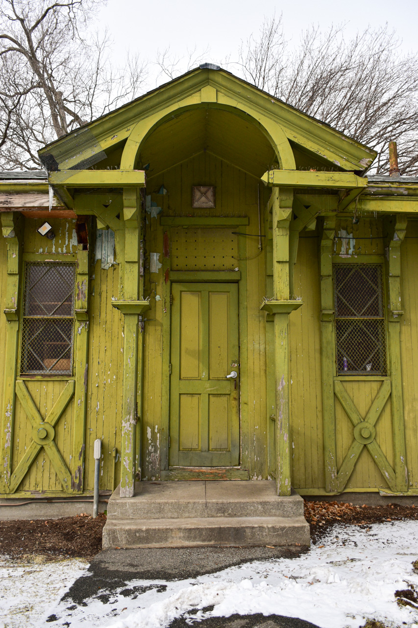
The tool house was built in 1946, replacing a women’s comfort station that stood there previously, according to this 2023 article in the Boston Sun. Architecturally, the 642-square-foot structure is reminiscent of the Victorian “stick style” bathroom it replaced, according to this 2023 article by the Beacon Hill Times.

Currently, the tool house is used by the Public Garden's facilities staff, as well as by operators of the Swan Boat ride in the adjacent lagoon.

There have been discussions in city government about renovating and expanding the quaint little building.

"Restoration of the tool house will include replacing its worn slate roof in kind and replacing deteriorating wood elements, including windows, wood cladding, and decorative wood trim – all of which are original to the building’s 1946 construction, said Bentson," the Boston Sun reported two years ago.

Architectural firm Utile is working with the Boston Public Facilities Department and the Boston Parks and Recreation Department on the project. "This expansion aims to provide much needed space for equipment storage and operations while carefully adapting to the various constraints of the site, including its adjacency to rare specimen trees," according to Utile's web site, where you can see renderings of the proposed work. "The new structure reinterprets the existing building’s Victorian façade elements in a modern and subdued language, allowing its newly-restored historic neighbor to remain the primary feature."

I'm not sure the status of the project.

Here's your headline explainer:

Yes, that's Pamela Anderson alongside Tim Allen and Richard Karn.

For another post about the Public Garden, and the adjacent Boston Common, see December 14, 2019, "Of Rugged Sports and Moorish Samaritans," about a memorial plaque and a statue.

Saturday, May 11, 2024

Learning About Boston's Schoolmaster Hill

From Dave Brigham:

As ruins go, the remnants of the superintendent's office in Boston's Franklin Park are about as clean, beautiful and well-built as you'll find.

Located in the heart of the park, overlooking the public golf course, the ruins are the main attraction of Schoolmaster Hill, so named because 200 years ago, this area was home to Ralph Waldo Emerson, his brother and his mother. In his early 20s at the time, the man who would go on to become an inflential preacher, writer, lecturer, poet and philosopher was working as a teacher in Roxbury.

While he didn't live here long, the time he spent in what was then the very rural area known as Canterbury influenced his life. "Emerson spent his spare time walking, reading and writing in his journal," according to Ralph Waldo Emerson: The Schoolmaster of Franklin Park, a book published in 1980 by the Franklin Park Coalition. "The journal entries give a good picture of how Emerson felt about living in Canterbury. And it is from these books that we learn whether the solitude of the woods and meadows was beneficial to the confused, bored young man."

The book quotes Emerson's journal: "I never saw a country which more delighted me. A man might travel many hundred miles and not find so fine woodlands as abound in this neighborhood."

Designed by Frederick Law Olmstead in the late 19th century, the 527-acre Franklin Park, which also features a zoo, a stadium (about which I will write in the near future) and old bear dens (see December 18, 2019, "Having a Bear of a Time at the Zoo"), "is the largest and last component of the Emerald Necklace created by...Olmsted," according to Wikipedia. "Although often neglected in the past, it is considered the 'crown jewel' of Olmsted's work in Greater Boston.

I had the ruins to myself on the late fall day that I visited. I found the stone walls -- amazingly untouched by graffiti -- to be pleasant photography subjects. I wandered at my leisure, comforted by the far-off sound of golfers hitting their drives, chatting with each other and gently revving their carts.

The property was "[o]riginally 'covered by vines on trellises and furnished with tables and seats,' [and] also provided complimentary hot water for visitors to make tea," according to this National Park Service web site. "A multi-use building, it at one time housed the superintendent's office and served as the golf course club house."

There is a plaque on a boulder memorializing Emerson's time here, and sharing some of his poetry.

Make sure to check back for my write-up of Franklin Park's White Stadium, which stands to change drastically in the near future, and another post about features of the park.

Saturday, February 18, 2023

The Loveliest Gatehouse

From Dave Brigham:

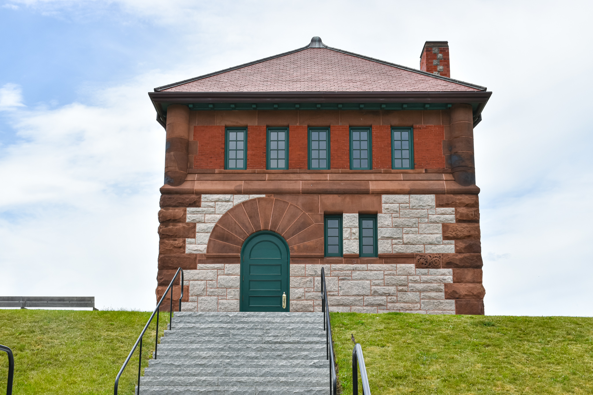
Quite some time ago I was struck by the idea of documenting gatehouses in Greater Boston, and compiling photos and writing about them here. Honestly, though, I'm not sure I'm going to find one that's lovelier than the one on Fisher Hill in Brookline.

Abutting the former Newbury College property, and across Fisher Avenue from a senior living facility under development, the former Fisher Hill Reservoir in 2016 was converted into a 10-acre park featuring an athletic field, a playground, walking paths and a promenade with sitting areas. The reservoir was drained and filled.

Built in 1886-87 under the direction of Boston City Engineer William Jackson, the reservoir and attendant gatehouse, which housed sluice gates, valves and/or pumps to control the flow of water, were eventually incorporated into the metropolitan Boston water system im 1898, according to the Massachusetts Historical Commission.

Built in the Richardsonian Romanesque style, the gatehouse "has a granite substructure, stone main floor, brick second story, and slate hip roof," per the historical commission. "Brownstone is used for quoins and window arches, including the oversized voussoirs above round-arched openings in the main floor. Raised relief terra cotta decorative panels on the building's facade are an instant (sic) of purely decorative detail unusual in the architecture of the Boston and Metropolitan Water Boards."

Lovely to look at, lovely to read about.

(A view of the athletic field.)

The gatehouse was taken out of service in the 1950s and sat unused for decades. In order to turn a long-abandoned gatehouse and reservoir into the fantastic public asset it is today, the City of Brookline turned to Argus Construction Corp. The company cut and removed invasive, unhealthy and dead trees and other vegetation, which comprised the majority of the plant material on site, according to the Brookline Recreation Department.

I still plan to make photos of more gatehouses and write about them here, so stay tuned.

For more Backside coverage of gatehouses, check out:

April 10, 2021, "I Seek Newton, Part X: Newton Centre (Section 3)"

December 5, 2016, "I Seek Newton, Part VI: Chestnut Hill"

Saturday, April 23, 2022

A Wonderful Walk in Wellesley Hills

From Dave Brigham:

While I've written a few posts about Wellesley (see May 18, 2012, "Aqueduct, My Friend" and January 20, 2018, "The Fabulous Baker Estate," which is more about Needham than Wellesley), this well-to-do town in Boston's western suburbs isn't the first town I think of when pondering on the backside of America. That's a bias I recently set about changing.

I started with a tour of Wellesley Hills, the neighborhood bounded by the Route 9/Washington Street intersection to the east, Wellesley Square to the west, Babson Park to the south and Wellesley Farms to the north. The commuter rail runs parallel to Washington Street here, and there are many commercial buildings, churches, apartment buildings, stores and older homes.

I started at Elm Park, a triangular slice of heaven tucked between Washington Street and Route 9. The park's prominent feature is the gorgeous Isaac Sprague Clocktower.

The brick-and-masonry tower rises 75 feet and features a clock and bell given to the town in 1874 by John Shaw, who worked in Wellesley's school system for many years. The tower itself wasn't erected until 1928. It is named for Isaac Sprague, who "sat on the committee which oversaw its construction, and donated materials for that purpose," according to Wikipedia.

There is also a very cool antique water fountain in the park.

The fountain was made by Murdock Manufacturing out of Cincinnati. I'm not sure how old the fountain is, or whether it works.

If you visit, look for the stone labyrinth at the southeast corner of the park, near the Unitarian Universalist Church.

Speaking of that church....

Built in 1888, the church has some wonderful architectural quirks, from the eyebrow window over the front door and the unusual spire, to the rounded, turret-like entrance near the rear of the building. The church was built for a congregation that formed in 1871 in what was then known as the Grantville neighborhood of Needham. Wellesley broke off from Needham in 1881. The grounds of the church also include an auditorium and a parish house.

Continuing southwest on the north side of Washington Street, I had to check out the bridge that carries Cliff Road over the commuter train tracks.

I don't check out bridges that often, but when I find one with such a great patina, I go out of my way. And I'm glad I did, as I spied a couple of nice relics.

Boston Bridge Works, Inc. was in business in the late 19th and early 20th centuries, as best as I can tell. The company had a factory somewhere in East Cambridge. To see a bunch of cool bridges built by the company, check out this Flick album.

(A nice plaque on the bridge featuring the Massachusetts State Seal, upon which I will not comment.)

I wasn't going to shoot a photo of the building below, but when I saw the sign indicating "PLAYHOUSE SQUARE" I figured this building had history to it.

Currently home to a law office and I'm not sure what else (the bakery went out of business in 2020), this building along Washington Street is known historically as the Wellesley Community Playhouse, and also the Babson College Clubhouse. It was built in 1921 by Babson for conferences, movies and theater productions, per MACRIS. From 1923 to 1986 the building was operated privately as a movie theater with 499 seats.

"The theatre closed because it losts (sic) its lease, not because it was unsuccessful (to the contrary, it did great business with second-run art stuff and kids' matinees [which I attended regularly] in the '80s)," according to a commenter on the Cinema Tour web site. The marquee was removed in 2008, according to a commenter on the Cinema Treasures web site.

The furthest west I went on Washington Street was to a neat old bus shelter in front of the town's police department.

Approved by the town's zoming board of appeals in October 1978 in order to provide residents of an adjacent housing authority complex with easier access to bus service, the shelter dates from the late '70s or early '80s. I've never come across a public transportation building quite like this one.

UPDATE: As of late June 2022, this bus shelter has been torn down.

Heading back east along Washington Street, I spied something in a parking lot behind the UPS Store that I decided to check out.

The Local is part of a three-restaurant chain (it was four until recently, when the Newton location closed). The Wellesley spot is situated in what I believe is a former trucking company building. MACRIS indicates a circa-1838 Greek Revival house was moved to this site in 1916 (and demolished at an unknown date after 1981). William and Mabel Diehl operated a moving company out of the house, which included a large barn at the rear of the property where they parked their vans and trucks, according to MACRIS. The barn burned down at some point. Albert and Laura DeBello operated the Wellesley Trucking Company here in the 1970s. I'm assuming the brick building housing The Local replaced the burned-down barn and was used to house the trucks.

Just steps away from the restaurant I found an entry point to the Crosstown Trail on Forest Street.

The trail starts at Wellesley's border with Natick, where the Cochituate Aqueduct Trail enters town. It winds through residential neighborhoods, borders Morses Pond, runs behind town hall, skirts the high school athletic complex, parallels Washington Street and eventually meets up with the Charles River Path.

I love paths like this that allow people to cut behind the main streets and through neighborhoods, getting views that we don't get when driving. Paths like this often upset residents (not just in Wellesley), because they bring the hoi polloi into close contact with locals.

OK, that's it for Wellesley Hills. I hope to check out other parts of town in the near future.

Tuesday, August 10, 2021

A Lovely Walk Through Roslindale Village

From Dave Brigham:

Sometimes I pore over online maps trying to find a place to explore. Other times, a location just pops into my head. That was the case with my recent walk through Boston's Roslindale Village neighborhood. I lived in neighboring West Roxbury for a few years a while back, and thought about returning with my camera. But then I remembered that Rozzie likely had more of interest to me, so that's where I ended up.

Located about six miles south-southwest of downtown Boston, Roslindale was originally part of the town of Roxbury, per Wikipedia. "In 1851, current day Jamaica Plain, Roslindale and West Roxbury seceded from Roxbury. The area voted in 1873 to be annexed to the City of Boston."

The neighborhood's name has an interesting origin story.

More from Wikipedia: "In the 1860s, the area was called South Street Crossing, due to the railroad's intersection with South Street. However, when the community applied for a post office district of its own, the name 'South Street Crossing' proved to be unacceptable to the government. The name Roslindale was suggested by John Pierce, a well-traveled member of the community, who told the assembled citizens that the area reminded him of the historic town of Roslin, Scotland, outside Edinburgh. Pierce thought the area was like a dale because of the hills surrounding it. Thus the combination of 'Roslin' and 'dale' was submitted to the United States Postal Service and the name Roslindale was formally established."

On my short visit to Roslindale, the first thing that caught my eye, because it just seemed so out of place, was Alexander the Great Park.

The statue at the center of the park was presented to the City of Boston by the people of the City of Athens, Greece, in 1997. The park is maintained by St. Nectarios Greek Orthodox Church and the Greek Spirit Committee.

Across from the park, on a small traffic island dividing Belgrade Avenue and Corinth Street, which is quite a busy intersection, is a whimsical sculpture.

Called, appropriately enough, "Traffic," this piece was sculpted by George Greenamyer, an artist who has a "moralistic message" and is "not afraid of preaching or offending others," according to his web site. I believe his Roslindale sculpture was installed in 2012.

I headed out southeast on Corinth Street, and quickly ducked down Birch Street. There, I found one of my favorite things to shoot: a social club!

My fascination with shooting social clubs is well documented here. I have a connection, albeit a tenuous one, to Sons of Italy clubs. When I turned 40, I joined a men's baseball league. I got drafted by a team called the Quincy Sons, short for Sons of Italy (see March 31, 2019, "A Slow Jog Around the Bases of My Memory"). I only went to the club once for a post-game drink, but I did get to hang out with a guy named Crusher.

Walking south on Corinth Street, I spied the lovely sign for the Blue Star Restaurant.

A little further south along Corinth, I spied another social club.

I'm not sure how long the club has been here. I found a short article online indicating that the club used to be in neighboring West Roxbury, but was forced to move from that location in 2009.

On the opposite side of the street, along the entire side wall of Family Dollar, is a faded mural.

I haven't been able to find out who painted it.

Across Corinth Street, on the side of Fornax Bread Company, I found another mural. There are so many great ones; a few more will follow below.

This one has been here for nearly 20 years. It was painted by Alex Cook, who has created more than 190 murals in 18 states and five countries, per his web site. He did at least one of the other ones I'll look at below.

At the intersection of Corinth and Washington streets is Mi Finca Mexican Food & Pizzeria.

I love the color scheme and the details on the building.

Across Washington Street is the Roslindale branch of the Boston Public Library.

Built in 1961, this circular building with a blue dome (it was tough to get a good photo, unfortunately) sits on a pentagonal-shaped lot and sits over an underground brook, according to the Friends of Roslindale Branch Library web site.

Directly behind the library, on Poplar Street, I spied the lovely contrast below.

This is a barn or garage behind a main house that was built in 1905, according to the Boston Assessor's Office. Obviously somebody takes nice care of this place. In my dreams, this quaint little building is filled with antiques and an old car or two.

Heading southwest along Washington Street, I was happy to see an old-school Irish bar, B.K.'s Pub.

I continued for a bit on Washington Street, as I knew I had to shoot the locally famous Pleasant Cafe.

In business more than 80 years, the Pleasant is best known for its pizza. I've only eaten here once, and that was many years ago, but I remember the food was excellent.

I swung back in the other direction, toward the heart of Roslindale Village. There, I spied a great mural overlooking the outdoor patio for Mexican street food restaurant Chilacates, which is named after a type of pepper. And yes, that's Mexican artist Frida Kahlo in the mural.

Continuing northeast along Washington Street, I made sure to shoot the former Roslindale Substation.

Built in 1911 as part of the power system for Boston's network of streetcars, the Classical Revival building is listed on the National Register of Historic Places. Empty for quite a few years (decades?), the substation was renovated in recent years, and is now home to Turtle Swamp Brewing's beer garden and perhaps other businesses.

On the side of Dragon Chef, at the corner of Washington and Basile streets, is the awesome mural below.

This fun and colorful work was done as part of the Boston Mayor's Mural Crew effort to beautify all corners of the city.

The sign for phone and computer retail/repair business Easy Fix caught my eye.

I like the dichotomy of the high-tech store next to Binta's African Hair Braiding.

Next door, at the corner of Murray Hill Road, is a wonderful marketing mural for this village.

This work of art is on the side of hair salon Studio M.

Continuing along, I saw one of the few missing teeth in the area, the former J&P Dry Cleaners.

As far as I can tell, the cleaners moved to Boston's Jamaica Plain neighborhood. Not sure if anything is slated to move into this space.

The side of the Roslindale Market -- "Now Serving Dominican Food" -- has a massive homage to the Boston Red Sox, including some high-profile players from the Dominican Republic.

(Top left corner is, I believe, Jason Varitek; lower left corner, could be Derek Lowe; to the right of Varitek, I'm guessing Johnny Pesky; below Pesky appears to be Manny Ramirez, from the Dominican; above Ramirez, I have no idea; next to that guy is Ted Williams; then Babe Ruth; below Ruth is, of course, Big Papi (David Ortiz); and in the upper right corner is Pedro Martinez. The latter two are also from the Dominican.)

The final mural on my tour is located on the side of the Little People's Playhouse on Washington Street.

This lovely work of art was created by Alex Cook, who I mentioned above.

Back in the main square of Roslindale Village, I spied the Prescott Building, which dates to 1929. This place, as with most older buildings, has an interesting history....

...so let's talk about that. Or rather, let's allow Historic Boston Inc. to share its knowledge: "In the early 1930s, [Anne] Prescott filed a permit to include an indoor miniature golf course in this building. Other long term uses included Charlestown Savings Bank, a beauty salon on the second floor, and Blair’s Foodland, for which a small 1 story rear addition was built in 1946. The building’s storefront has been altered several times."

And here I thought that indoor mini golf courses were a newfangled thing (relatively speaking)!

Steps away from the Prescott Building, I found what I'm always looking for, but rarely find these days: a ghost sign!

Located at the intersection of Corinth, Poplar and Washington streets, the sign is difficult, if not impossible to read, unfortunately. I asked a former longtime Roslindale resident if he had any clue, and he said, "Sorry, nope." I believe this building was once the Roslindale Department Store. It dates to 1890. If anyone has any idea about this ghost sign, please let me know in the comments below.

Well, that wraps up Roslindale Village. For the only other post I've written about this Boston neighborhood, see November 30, 2017, "Stone Cold Monuments."

Way Down Yonder in Pawtucket, Part I

From Dave Brigham: I apologize in advance for this, but I often feel the need to explain my headline choices: I'll admit that befo...