Showing posts with label industrial buildings. Show all posts

Saturday, August 30, 2025

Walking Through My Old Man's Stomping Grounds, Part I

From Dave Brigham:

A child of the Great Depression, my dad moved around a bit in his early childhood, due to the fact that his father had lost his business. Eventually, the family settled in Springfield, Mass., where my dad spent his formative years. He went to his hometown school, Springfield College, and talked about the city on occasion when I was growing up, mentioning Indian motorcycles, which used to be manufactured there, and the invention of the game of basketball on his school's campus.

I visited the original Basketball Hall of Fame, which was on the college campus, when I was a kid. I also went to a cemetery in the city when my grandmother died in 1989. But other than that, I hadn't spent time there until the spring of 2014 (see April 14, 2014, "Coincidence?"). I finished that post with these words: "I hope to get back to Springfield in the near future to explore more cool buildings, and to learn a bit more about the city that helped shape the great man who was my father. Rest in peace, dad."

I made my initial visit to Hoop City just two weeks before my father passed away. I finally returned 11 years later, less than a week after my mother passed away. Springfield has taken some economic blows over the decades, but I found plenty of signs of life, as well as great old buildings, restaurants, bars, signs and more in the Metro Center area that I explored.

Located in the northwest quadrant of the city, near I-91 and the Connecticut River, Metro Center is the beating heart of Springfield, "with more than 60 clubs, restaurants, and bars — numerous festivals, cultural institutions, educational institutions, and significant historic sites," per Wikipedia.

As I often do, I researched online ahead of time to find a good starting point. The old Paramount Theater on Main Street fit the bill (but it is the final site in this post). Around the corner, on Lyman Street, hard by the railroad tracks serving Springfield Union Station, I happened upon what for me is a rare find: a lovely bit of novelty architecture.

A.W. Gifford, Inc., a full-service locksmith, has been in business since 1866. This building rose in 1950, but I haven't been able to find out anything about the architect. I wish more buildings had designs connected to their use.

A short distance away, heading northeast, is the Powers Block, which dates to 1873 and was built for the Powers Paper Company.

In more recent years, this complex was home to W.F. Young, which was founded in 1892 as a manufacturer of horse liniment. In the photo below, you can see the "W" of the company's name in the lower right corner.

W.F. Young is now located in neighboring East Longmeadow. The company's products include ones that provide wound care and joint support for horses, as well as snacks for cats and dogs.

I crossed Chestnut Street to get a shot of the very cool work of art someone created using elements of a ghost building.

These phantasms are working hard, lugging things up and down the stairs, imagining a time when the Collins Block was a busy warehouse of cotton waste for the E.F. Collins Company. The building dates to 1910, and is currently quite derelict. I haven't found out who painted this.

I made my way to Taylor Street, which parallels Lyman Street to the southeast. I shot the rear of the Baystate Corset Block, which was a mish-mash of paint colors and add-ons and industrial and restaurant space.

"This large block was built in 1874 to house two woodworking concerns," according to MACRIS. "P.P. Kellogg, who had bought the building five years earlier for his paper products business, built an addition along Taylor Street. Ten years later, Bay State Corset began manufacturing their 'women's and children's waists.' They remain located here through 1920.

"During its peak years, Bay State Corset Company produced 5,000 corsets daily," MACRIS continues. "The top floor was devoted to cutting rooms, the middle two floors to over 400 sewing machines run by young women workers. In all, 75 to 80 different styles of corset were produced. The firm was one of the largest makers of corsets on the continent and sold its goods to wholesalers and retailers nationwide."

I shot an old corset manufacturing building in Worcester back in late 2023, one of dozens that used to operate in that city (see February 3, 2024, "The Shire of Worcester, Part the Second").

The old Baystate Corset Block is occupied in part by Smokey Joe's Cigar Lounge and CreepSheek Studio, which strives "to bring eclectic, whimsical, unapologetically acceptable out of the box beauty to Springfield."

As for the restaurant facade along Taylor Street, below, I guessed it was an Italian eatery.

I assumed it was closed, but the Internet tells me that 350 Grill Steakhouse is alive and well (unlike its main course - bada bing!). While there is Italian food on the menu, I wouldn't call it an Italian eatery.

Continuing southwest on Taylor Street, I came to the Stacy Building, which was built in 1893 for a company that manufactured and dealt in machinery and mill supplies, according to MACRIS. But there's more!

The Stacy Supply Co. leased out the upper two floors in the early days. According to MACRIS, one of the tenants was J. Frank Duryea, who, along with his brother, invented the first gasoline-powered automobile in the United States - right in this building!

After some initial work and testing, "Duryea decided to build a car 'with the Machinery (sic) well concealed in the body....Built with a 2 cylinder, 2 cycle motor, my (??) gear and clutch transmission giving 3 speeds and reverse, this vehicle had its first test on the top floor of the E.S. Stacy building late in 1894,'" according to MACRIS. "Tests were promising and after the engine was converted to four cycles, this was the car that J. Frank Duryea drove to win the Times-Herald race on Thanksgiving Day 1895 in Chicago. This was the first automobile race in America, and the Duryea entry was the only 'American made gasoline car to start.'"

Near Taylor Street's intersection with Main Street is a complex of old mill buildings that have been converted to the Silverbrick Lofts.

These buildings are part of the Powers Block complex mentioned above.

Across Main Street, at the corner of Worthington Street, is the Bowles Building, which houses a Springfield institution that I'll get to in a minute. Hold your horses!

This place dates to 1858 and has been "altered beyond recognition" and is known historically as the Fort Block, per MACRIS. The name comes from the site's history as the location of a fort built by John Pynchon in 1660 to protect townspeople during King Philip's War. The block was erected by Springfield's first insurance company, Springfield Fire and Marine Insurance Co. Over the years, banks, newspapers and business schools occupied the space.

The upper floors have been vacant since 1997, and there is a redevelopment plan in the works (I think) for the 66,000-square-foot building, according to this Rebuild Springfield document. The plan is for the ground-floor retail to remain, and for the upper floors to be converted to office or residential use.

OK, let's get to that ground-floor retail/restaurant space, located on Fort Street.

Finally we arrive at a place where I know my dad spent time: Student Prince and the Fort.

Established in 1935, the Student Prince was originally smaller, with just a bar and space for booths, and a small collection of beer steins. In 1946, according to the eatery's web site, ownership added the dining room. Over the ensuing decades, the place grew into a local landmark and the stein collection grew to be one of the largest in the United States. Go to the Gallery page on the restaurant's web site to see the inside of this place, including some steins.

I don't recall my dad mentioning this place, but one of my cousins said she's sure that her dad and mine had been to the Student Prince over the years. It seems like an obvious Springfield College hangout.

I've been there twice. The first time was in 2010, the morning after seeing my favorite band, the Flaming Lips, at Mountain Park in nearby Holyoke. The second time was during the aforementioned trip to Springfield a few weeks before my dad passed by. I recall eating too many sausages and being completely floored by the stein collection.

At the end of Worthington Street, where it meets East Columbus Avenue, is a fantastic old building.

Known as the Homestead Building or the Phelps Publishing Company Building, this Romanesque Revival beauty dates to 1903. "The Homestead Building served as the general offices for the Phelps Publishing Company," according to MACRIS. "The company published a local weekly, the 'Springfield Homestead' and three other weeklies including the 'American Agriculturist of New York which enjoyed a wide rural circulation. In 1932 this building was taken over by the Blue Line Transportation Company and it was at this time the first floor facade was altered and an entrance was placed in the corner at the base of the tower."

Take note of the town crier blowing a bugle above the entrance to Noir, a nightclub that may no longer be in business.

At this point, I doubled back to Main Street, where I made some photos of the old Worthy Hotel, which I featured in my Springfield post from 2014.

This is a gorgeous building. I'd like to think my father went to an event of some sort here in his younger days, perhaps escorting a young woman from his high school or college. Built in 1895 as a six-story building, the hotel was raised by two stories in 1905, and then expanded into a neighboring office building four years later.

Now an apartment building, the Worthy has two ground-floor retail spaces. City Jake's Cafe has been in business for more than 30 years; Kim & Lee is a jewelry store that sells, among other things, gold teeth name plates.

Across a small plaza is the Fuller Block, a splendid Romanesque Revival building that dates to 1887, and which I didn't get the best photo of.

From MACRIS: "It was reported at the time of construction that the Fuller Block was the 'first to include every metropolitan convenience, passenger elevators, steam heat, a mail chute, running water in each suite of rooms.' It was also reported the first to have Georgian marble floors and wainscoting and a marble staircase. The building attracted a high class of tenants with two or three first quality clothiers on the first floors and several physicians on the upper floors."

All mod cons, as the Jam would say. Today's tenants include architecture and design firm Dennis Group.

I doubled back to Worthington Street, this time heading northeast. I was happy to see signs for Theodore's (Blues, Booze & BBQ) and Smith's Billiards. I'm guessing these businesses are related.

Theodore's has been in business for more than 30 years. Smith's traces its history back to 1902 as a billiard academy. They are located in Smith's Building, which was built in 1897 and was constructed in the Romanesque Revival and Queen Anne's styles, per MACRIS. From its first days until 1913, this block was occupied by McIntosh Shoe Company, which was "not only the oldest but the largest inland boot and shoe jobbing house in the New England States," per MACRIS.

In 1914, "Fred Smith moved his billiard parlor and bowling alleys to this block," MACRIS continues. "He had begun business in 1903 in the block next east of this one, and had acquired a number of pool and billiard tables from the 1905 St. Louis Exposition. In the new setting the second floor was utilized as a billiard parlor, and the upper floors for the bowling alley. Before World War II 'the center of candlepin bowling in Western Mass. was located in downtown Springfield in the upper three floors of the Smith Building.'"

Across Worthington Street is the King Block (on left).

Home to Offsite 2twenty2, this little building has a big history. Originally a five-story addition to the building just to its west, it was used by a wholesale and retail paper dealer when it was built in 1892, according to MACRIS. In 1900, George Hendee, a "national bicycling champion from 1882 until 1887," moved his bicycle manufacturing business to the fifth floor of the King Block.

"At this time Hendee was developing an interest in motorized bicycles. After meeting Oscar Hedstrom, an engine designer from Brooklyn, he decided to develop a motorcycle for general use. Within a year the first machine was completed and named the 'Indian Motocycle.' The year 1902 was the first quantity production year with 142 being produced."

Eventually, Hendee moved one block west, and then, as sales increased, took the company to Winchester Square, which is now known as Mason Square. I'm pretty sure that my dad grew up close to Mason Square, which is probably why he talked quite a bit about Indian Motorcycles when I was a kid.

Meanwhile, back at the King Block: it eventually became home to the John Boyle O'Reilly Club, "probably the largest and longest lasting Irish American social club in Springfield," according to MACRIS. The club was formally incorporated in 1933, and was located here until the late 1940s.

Next door is the Royce Block, which was most recently home to Dewey's Jazz Lounge. The venue closed in April.

This Italianate building rose in 1887 for Charles Royce's laundry business. The company moved to larger quarters by 1915, and this building was used as a hotel and boarding house for many years afterward.

This area of Metro Center is a prime destination for eating and entertainment, as you may have guessed. These places are equidistant from scores of vacant lots that were once factories of various sorts, and the MGM Springfield, a casino complex that opened in 2018. I will feature a few shots of the casino in a future post.

There are two cool murals along Worthington Street that really liven up the street.

This "Wizard of Oz" artwork made me chuckle. My dad, you see, acted in community theater for most of his life, and over the years he took on several roles in this play, from the Tin Man to the Wizard to an apple tree.

I believe this mural was painted as part of Springfield's City Mosaic initiative, which over the past two decades has completed multiple projects across the city.

Perhaps the most ambitious project is the recreation of a wall mural on the side of the Driscoll Building for the defunct Bloom's Photo Supply.

"Several years ago, [artist] John [Simpson] and I were approached by State Representative Sean Curran who thought it would be a great idea to paint a mural and restoration on a building on Worthington Street, whose wall faces the neighborhood which was once a thriving entertainment district," Evan Plotkin, a local businessman and board member of City Mosaic, says on the group's web page about this project.

Initially, the team rejected the idea of restoring the mural, which had faded quite a bit over the prior six decades. "After several meetings and listening to members of the Historical Commission, who spoke to us repeatedly and passionately about the intrinsic value of the old advertisements and the historic value they represented, we changed our minds," Plotkin said.

The restoration, unveiled in August 2022, is remarkable. It is vivid and bold and detailed and pays homage to many sectors of Springfield's past and present. "The wall is no longer a wall," Plotkin says. "It is a piece of art, and it is more than just art. It is a window to the past, a vibrant, colorful part of the present, and a bridge to the future."

Well said, and well done.

Simpson worked with at least two other artists, who are featured in a photo on the City Mosaid web site, but not named.

Below is a video of Plotkin, Simpson and others discussing the spark for the City Mosaic project.

We move from that big, beautiful mural to a smaller, but no less important one, painted on a shuttered watering hole tucked into an old train bridge that crosses Main Street near Union Station.

The Stone Wall Tavern opened in the 1940s, I believe, and closed for good several years ago. The building was originally a food shack for train workers according to the video below.

The tavern's name echoes with the name of the famous New York City gay bar that was the scene of a 1969 police raid in which bar patrons fought back, a watershed moment in the LGBTQ community (read all about it here). I mentioned the riot, and one of the prime instigators, in a well-after-the-fact post in February 2022 about a visit to NYC (see February 5, 2022, "New York Flashback: Views While Strolling and Shopping").

The Springfield tavern is so named because it is literally made of stone, and the back wall of the place is part of the stone bridge over Main Street. Still, it makes for a great symbiosis between the well-known historical event and a local group working to support LGBTQ youth. If I'd known the significance of the mural, I would've made better images of it. The work was painted as part of the Common Wealth Murals initiative, which "collaborates with communities to create powerful public art that honors histories, celebrates local heroes, and inspires bold visions of the future," according to the group's web site. Common Wealth partnered with Out Now, which calls itself "[t]he only queer youth organization in Springfield."

"The story of this mural, it's a comparison between the experience that queer youth have in school now, and then a radical reimagining of what school would look like if it was conducted in a way that was really supportive of queer youth," according to Britt Ruhe, director of Common Wealth Murals, in the video below.

The mural project was led by Mimi Ditkoff, working with members of Out Now. I will feature another of her murals in the next Springfield post.

Last, but not least, is the old theater I mentioned at the top of this post.

Located on the opposite corner of Main Street from the Stone Wall and known most recently as the Hippodrome, the theater opened as the Paramount in 1929, inside the former Massasoit Hotel. The hotel closed three years prior, and the space was converted to offices, according to this After the Final Curtain blog post.

The hotel opened in 1843 in a separate building on this location, I believe. The current building dates to 1857; it was substantially rebuilt in 1912, according to MACRIS. The hotel served as a stop on the Underground Railroad prior to the Civil War, according to this article from the Springfield Museums.

The Paramount was a 3,200-seat theater offering movies, vaudeville acts and concerts, among other entertainment. By the mid-1960s, live concerts had become more popular for the theater. "In 1969, the Paramount closed for the first time," according to After the Final Curtain. "It reopened In 1975 and was renamed the Julia Sanderson Theater, after a Broadway actress from Springfield. Live shows continued at the theater until 1979, when it became a revival movie house, and its name was changed back to the Paramount. A new screen, and a speaker system taken from the recently closed Victory Theatre, were installed. It closed for a second time in 1986, but was used occasionally until 1999."

In December 2000, after spending $1.3 million to upgrade the facility, Paramount Realty Investment/Creative Theater Concepts reopened the space as the Hippodrome, a live entertainment and nightclub space, according to After the Final Curtain. "The Hippodrome was a popular nighttime downtown destination for most of the 2000s," After the Final Curtain indicates. "In 2011, it was purchased by the New England Farm Workers Council (NEFWC) for $1.7 million. They operated the theater sporadically until closing for good after a shooting in April 2015."

The NEFWC sold the theater for $750,000 to Sachdev Real Estate Development Inc., a Connecticut corporation based in Suffield, last September. I'm not sure whether a redevelopment plan has been unveiled. Let's hope for something great at this place that, let's face it, my dad probably visited at least once during his time living in Springfield.

(Entrance to the Massasoit Building. The plaque on the right indicates it was built in 1843, and restored in 1986.)

Make sure to check back for the second part of my Springfield expedition.

Saturday, August 31, 2024

Floating Through Fall River, Part II*

From Dave Brigham:

* No actual floating was undertaken in pursuit of this and other posts about Fall River.

I know I say this a lot, but I've had the old manufacturing city of Fall River in the back of my mind for years. I recall driving past numerous old mills along Interstate 195 on my way to Newport, R.I., many years ago, and being quite intrigued by the granite buildings, which are much lighter in color than the typical brick factories I see around New England.

In my first post about Fall River, I discussed signs, a mural, tile entryways and ghost signs (see August 24, 2024, "Floating Through Fall River, Part I*").

In this post, I will cover mill buildings and one fairly gritty non-industrial property. There will be a third post about everything else that I typically obsess about on this blog.

There are more than 60 historic textile mills in Fall River, down from a high of at least 120 in the 19th and early 20th centuries, when the city was the leading cotton textile center in the United States, according to Wikipedia. I only had time to check out a handful of the old mills, but I hope to return to scope out more.

The first mills were established in Fall River (at the time, part of Tiverton, Rhode Island) early in the 19th century. "The Quequechan River, with its eight falls, combined to make Fall River the best tidewater privilege in southern New England," per Wikipedia. "It was perfect for industrialization — big enough for profit and expansion, yet small enough to be developed by local capital without interference from Boston."

Evidently, I made a damn good choice for the first building I checked out - the former Chace Mills on Lewiston Street, hard by the interstate and the Quequechan River.

"The monumental granite Chace Mill of 1872 has been called the most imposing and attractive in the city and stands out because of its relatively isolated site and finely detailed Italianate stair tower," per MACRIS. "The Chace Mills was one of 15 textile companies organized during the years 1871-2, a period of remarkable expansion in the city's manufacturing capacity. Capitalized at $500,000, the mill was named after one of the organizers and first president, Augustus Chace....The first mill was erected in 1872 and had a capacity of 43,480 spindles and 1,056 looms producing 12 million yards of print cloth annually. A bleaching, dyeing and finishing mill was added in 1895."

That's a lot of print cloth!

As regular readers know, I love New England's old mill towns, from the former factory buildings that have been redeveloped into artist/living/office space to the ones that stand derelict, from the wonderful architecture making up the city halls, banks and social clubs to the old bars, theaters and commercial districts. As hard as I try, I find it hard to visualize what these cities were like when they were going like gangbusters, with thousands of mill workers coming and going, trains and ships filling up with textiles and other products, diners jammed from end to end with workers filling their bellies, taverns loud with the noise of after-work crowds.

By the late 1920s, a company called Arkwright took over this facility. In 1999 there was a fire here, with some smaller buildings destroyed. There is a UHaul facility here currently, and perhaps other businesses. I was reluctant to walk around this place for too long, as there were a couple of sketchy dudes hanging out watching me, and my time was short.

At the corner of Rodman Street and Plymouth Avenue stands the Davol Mills, a more traditional brick complex, albeit one with a Mansard roof, which is a bit unusual. MACRIS says this is the sole survivor of Fall River's Mansard roof mills.

From Wikipedia: "The Davol Mills Company was organized in 1866, with nineteen persons, with initial capital set at $270,000, and named in honor of William C. Davol, a machinery builder who is credited with importing the Roberts Self-acting Mule from Great Britain to Fall River in the early 1840s. Mill No. 1 was built in 1867 at the corner of Rodman Street and Eight Rod Way (now known as Plymouth Avenue). The machinery was in operation by March 1868. The Davol Mills initially produced cotton shirtings, sheetings, silesias [thin twilled woven cloth made of linen or cotton] and fancy fabrics. In 1871, Mill No. 2 was built along Hartwell Street, connected to the first mill. By 1917, the Davol Mills contained 44,000 spindles and 1,258 looms. The company acquired the nearby Tecumseh Mills in 1924. It shut down in 1935."

The mill, which is included in the Corky Row Historic District, was taken over by the Dover Stamping Company at some point. Current occupants of the old Davol place include Gold Airport Transportation and the Medical Drug Testing Laboratory, among (I think) others.

From the old Davol mill, I walked north-northeast past the former Tecumseh Mill, which was converted to apartments in the 1980s. I opted not to make any photos of it. At 138 Hartwell Street, though, some buildings caught my eye.

This is the former Frank M. Silvia School, which was built in 1902. From what I've been able to find out online (without the benefit of a subscription to the Fall River Herald News), the school was closed a while ago and the city has been trying to find a developer to take on a project here. Next door is a former school building division complex.

Along Pleasant Street, between 7th and 12th streets, is the most impressive complex I saw: Durfee Mills.

Again, my time was limited - and I was fighting the sun, so I only made a few shots. From MACRIS: "Durfee Mills was the largest single firm of textile manufacturers in Fall River. The mill buildings, standing at right angles to Pleasant Street, with the granite office bldg. between them, are among the most visually significant industrial structures in downtown Fall River."

More from MACRIS: "The firm was organized in 1866 with a capital of $500,000 and named after Major Bradford Durfee, whose son, B.M.C. Durfee, was the principal stockholder and original president. Major Durfee has been credited as 'the originator of plans which were the inception of Fall River's industrial life.' With Colonel Richard Borden, he was the founder of the Fall River Iron Works Company, which began as an iron manufactory and which constructed many of the city's earliest textile mills. The first two Durfee mills were erected in 1866 and 1871, and in 1877 the company had a capacity of 87,424 spindles and 2,064 looms. Its product was print cloth, of which 23 million yards were made in 1877, consuming 9,500 bales of cotton and employing 950 operatives. After the #3 mill was built in 1881, the firm had a capacity of 109,360 spindles, a number which increased to 151,328 by 1920. During the 20th century, the company remained the largest Fall River textile firm not part of a larger conglomerate. The corporation was liquidated in 1935."

Today, there are numerous businesses located in the complex, including Prima Care Medical Center, the accounting firm of Dorman & Associates, the General Fitness gym, Regiment martial arts training center and Delken Dry Cleaning.

Heading east-southeast on Pleasant Street for a bit, you will come to the Stafford Mills complex at the intersection of Quarry and County streets.

Currently occupied by Globe Furniture Outlet and probably other businesses, the old Stafford buildings date to 1872, 1888 (the granite mills) and 1896, the detached, Richardsonian Romanesque brick office building (pictured below).

From MACRIS: "The Stafford Mills was one of 15 textile corporations founded between 1871 and 1872 during a period of rapid expansion of the city's manufacturing capacity (hmm....seems I've read this somewhere before). The company was organized in 1870 but reorganized in 1871 with a capital of $550,000. It was named in honor of its founder and first president, Foster H. Stafford, a man who began working in mills as a young boy."

Stafford Mills closed in 1929. I'm not sure if another manufacturing operation took over at that point.

The final site on my mill tour is special because it still functions as a manufacturing hub.

The No. 2 Granite Mills building on Bedford Street, between Robeson and Seabury streets, was built in 1871 as part of a larger complex. The Granite Mills was a textile operation founded in 1863 that made, according to MACRIS, "fancy goods as well as plain cloth, and the beauty and elaborateness of some of the products was (sic) noted in a 1902 review of the American cotton industry....In 1932 the company was sold to the Pepperell Manufacturing Co."

Subsequent to the Pepperell Company, the mill buildings were owned and occupied by Anderson-Little, a men's clothing manufacturer and retailer that was founded in the 1920s in Boston and moved to Fall River in the 1930s. I remember seeing TV commercials and newspaper ads for the brand when I was a kid. The company closed in 1998, but the brand has been revived as a web-only retailer.

Currently, the Granite Mills building is occupied by the Merrow Sewing Maching Company, an operation founded in Connecticut in 1838 that has been in Fall River since 2004. Joseph Merrow started a business in the Nutmeg State manufacturing gunpowder, but after a fire destroyed that mill, he turned to making knit cotton goods, according to the company's history on its web site. In due time, Merrow began manufacturing sewing machines.

The company continued to grow internationally. In 2010, the founder's great-grandnephews moved operations to Fall River.

Make sure to check back for the third and final post in this series, in which I will discuss a diner, named buildings, a church, fraternal organizations and much more.

Saturday, February 11, 2023

I Seek Newton, Part XIII: Newtonville (Section 3)

From Dave Brigham:

This is the end.

Welcome to the final post in my "I Seek Newton" series, which I began publishing in May 2015 (see bottom of this post for links to all other posts). I was naive at the beginning, thinking I would crank out coverage of Newton's 13 villages in about 18 months, give or take a month. At that time, May 2015, four years into the life of the blog, I had other folks contributing on occasion, so I figured I'd focus on this project while still featuring other local towns and cities. I was regularly riding the subway into Boston with my son, so I often wrote about different parts of the capital city.

In August of 2015, my son started attending a school in Sudbury, so I began exploring that town and surrounding ones after I dropped him off. I was a stay-at-home dad, so I had the time. I walked through towns such as Stow, Maynard, Littleton, Hudson and Clinton and got to know them as well as I could in a few hours, before I had to return to my son's school. I began taking a lot more photos, doing heavier research and really enjoying the process.

I discovered some cool old mill cities and some neat places in suburban and rural towns I'd barely heard of before stepping foot in them. As you can imagine, this began to take up more of my time. As a result, my timeline for the "I Seek Newton" series began to stretch out. And, honestly, since I'd driven through Newton so much over the years, both before and since moving here, I'd come to think of it as boring, while these other surrounding towns and cities held more intrigue for me.

But as I always say, you don't really get to know a place until you walk around it, breathe it in, see the historic markers and named buildings, and walk down its back alleys. So every time I would explore one of Newton's villages, I would not only learn from the experience, but also be thrilled anew about the project. And as the series carried on, I found myself digging deeper into each village, so the process for each one ended up taking longer than the first few I completed.

I want to thank all the Newton folks on various Facebook groups for their support of this series. They have answered my questions willingly, happy to help out a guy who moved here in 2003 with little knowledge of the city. And they have shared their memories of places I have mentioned, provided historical background and the occasional correction, and shown a true appreciation for what I have done with this project.

OK, before I tear up, let's get to it!

I finished the last post talking about Avery Woods and the former Albemarle Golf Course. I'm starting this post with another open space, Cabot Park, and its field house. The park has 11.6 acres, and was developed in the late 1800s thanks to the largesse of several residents who donated the land.

Built in 1926, the field house faces East Side Parkway, which, despite its name, is not a New York City highway. The building was designed with a recreation room, showers and lockers, according to MACRIS, and anchors the eastern flank of the park. Other park features include tennis courts, an off-leash dog park, baseball/softball fields and, of utmost interest to my dog, plenty of squirrels. The park abuts the Cabot Elementary School.

The park is also adjacent to Cabot Park Village, a senior living community, seen in the photo below taken from the complex's driveway.

Pardon me, while I tell a quick story that highlights how much of a dork I am about doing this stuff. In the early days of this project, I pored over old Atlas maps available at the City of Newton web site. It was from this research that I began to sketch out places to explore that weren't so obvious. I found out about old schools and factories and mansions and much more. One of the places I noticed on the 1929 map was a large building located between Norwood Avenue and Munroe Street, next to Cabot Park. It wasn't labeled, so for years I've just had the notation "former factory?" in my notes about this spot in Newtonville.

Well, I just had to find out what this place, located where Cabot Park Village now stands, had once been. Once again turning to my old friend MACRIS, I found the answer in a sideways fashion. There wasn't a listing for this property, but one under the heading of "Cabot Park" led me to my answer. This was once the location of Security Mills, a paper company.

I haven't found out much about the business, other than that the City approved construction of the plant in the spring of 1922 on a three-and-a-half acre site. "Community activists, including the Newtonville Improvement Society, negotiated to stop the plan," MACRIS indicates. "The city considered several alternative actions, but finally decided that intervention would set a bad precedent. Thus, construction of Security Mills was approved just six months before passage of the zoning ordinance which could have prevented it."

By 1987, according to MACRIS, the site was under consideration for redevelopment. I don't know what Security Mills manufactured or how long it was on the site. I'm hopeful that Newtonville folks will fill in some details for me.

I'm always happy to fill in a gap in my Newton knowledge.

This area of Newtonville Avenue, from Farquhar Road to Lewis Terrace, is a mix of residential and commercial properties, and has been for more than a century. In order to figure out what was there a century ago, I again had to rely on subsequent reviews of the Atlas maps, as well as my notes from years ago, and, of course, Google.

On the 1917 Atlas map, across from where Carter Street hits Newtonville Avenue, is a property listed as "GREEN HOUSES," and the name "Robert C. Bridgham" (a distant relative of mine, perhaps?!). The 1929 Atlas map features the name "Augustus Calder" next to the buildings. An Internet search turned up a man by that name, "the son of a market gardener who lives in West Roxbury, a suburb of Boston," in a publication available for free via Google Books called The Horticulturist and Journal of Rural Art and Rural Taste, Volume 23, which dates to December 1868.

Perhaps the Calder listed on the 1929 Atlas map was the son or grandson of the fellow mentioned in that periodical. Currently, that site is populated by homes and a parking lot. I don't know how long the greenhouses were there, or when they were torn down. Again, I'm hoping at least one of my readers can fill in some details.

Also on the 1929 map are buildings labeled for "Boston & Albany Railroad Co," alongside a handful of train tracks that dead end by the greenhouses.

So what's there now?

The train tracks behind the greenhouses were replaced by a warehouse building, set back along the dead-end Albany Street, that is split by TIEM Athletic, which makes women's athletic shoes, and Clark Fine Art Services, which provides fine art installation, packaging and transportation in and around Boston and throughout the northeast, per the company's web site.

At the corner of Albany Street and Newtonville Avenue is another warehouse, this one in recent years home to Cradles to Crayons, a nonprofit battling childhood poverty. The building dates to 1959, according to the assessor's database. I'm not sure what was there prior to the charity.

The building I'm most interested in is between Cradles to Crayons and the Mass. Pike. It is home to an outlet of doggie daycare facility Pooch Hotel.

According to the Newton assessor's database, this building dates to 1925, which means it's almost assuredly a relic of the Boston & Albany Railroad days. In my online research, I found information from The Newton Graphic, dated June 3, 1927, about this building. "The Massachusetts Wharf Coal Company was given a permit for a pump and 1000 gallons gasoline tank for private use at 285 Newtonville avenue (sic)."

I'm guessing that company provided coal for engines on the railroad.

In the lot adjacent to Cradle to Crayons, to the east, is a CubeSmart storage facility, which opened in the last year or two.

Prior to that, a company called Norcross Corp. was located there. Founded, I believe, in the 1940s, Norcross manufactured "industrial viscosity control systems not only in textile production, but in a wide array of industries including printing, packaging, electronics, energy, automotive manufacturing, and food production," according to the web site of Saint Clair Systems, with which Norcross merged in 2014.

I'm guessing that some of the Saint Clair/Norcross meetings go something like this:

(Former Norcross Corp. buildings.)

Heading west on Newtonville Avenue a few years back, when I was first making photos for my Newtonville posts, I spied two cement columns with the letter "K" on them.

I wondered what the story behind them was, but didn't investigate until I was ready to put together this post. A member of one of the Newton-centric Facebook groups I belong to provided the answer, when I posed the question: "Those are antique driveway markers for the Victorian house at 9 Farquhar Rd. That whole block used to be one estate. The other two markers are on Harvard St."

Sure enough, a check on MACRIS told me that the house is known as the Kimball Mansion (hence the letter "K" on the posts). "Local history maintains that this large Stick Style residence was constructed by Fayette Shaw for his daughter, Sillinda's wedding present when she married William F. Kimball," MACRIS reports. "Kimball was employed by Shaw at the Fayette Shaw Leather Company. The design for this elaborate house features numerous wall and roof projections that include a square, three-story tower with a pyramidal cap, and an ornate third-story balcony. The gable-roofed balcony contains intricate Stick Style trusses and is supported on turned posts. A multi-gabled verandah is found on the north and west elevations of the house, and features a polygonal southern termination that resembles a gazebo."

(9 Farquhar Road.)

(Driveway markers for 9 Farquhar Road located along Harvard Avenue. Notice they are different heights. They also look older than the other pair, making me wonder if the first pair featured may be reproductions.)

Farquhar meets up with Harvard Street very close to Bowers Street, the western end of which is my favorite spot in all of Newtonville.

When I first stumbled across the Colony Coin Company shop several years ago, I felt like I'd stepped back in time. I've never set foot in the store, despite my lifelong interest in coins of all sorts, but I just love the hand-painted sign, the assortment of books, photos, antiques, memorabilia and, of course, coins, in the windows. Founded in 1962, the coin business is open limited hours.

Next door is pet grooming business Soft Paws, and adjacent to that is a used furniture and collectables store called Come and Get It Shop. Tucked away behind a two-story office and retail building on Newtonville Avenue, and in the shadow of a former church on Walnut Street, these shops don't snag many customers who just happen to be walking by. You have to know they are there.

Dated to 1896, the building was erected by Prescott Bridgham, "a Newtonville resident who frequently speculated in real estate," according to MACRIS. I'm guessing he was related to Robert Bridgham. When this building rose, this corner of the village was much more bustling, as the Newtonville train station was located directly across the street. The train station was demolished in the early 1960s during construction of the Massachusetts Turnpike extension into Boston.

The low-slung retail shops are nestled next to the two-story 80 Bowers Street, which also dates to 1896.

MACRIS doesn't have a lot to say about this Colonial Revival office/retail building, but the service's write-up did send me to Google to look up "diaper brickwork." Per Wikipedia: "In architecture and other decorative arts, diaper is applied as a decorative treatment of a surface with a repeat pattern of squares (chequers), rectangles, or lozenges." In the case of 80 Bowers Street, this refers to the pattern of bricks seen over the front door and near the roofline.

Currently, the first-floor space is occupied by, well, I'm not exactly sure. Signs in the window say "Welcome to the Newtonville Depot" and "ebay spoken here." If anybody knows, let me know. As you can see by the ghost sign in the photo below, this was once home to Johnny Gallagher's Garden City Motor Parts.

While Bowers Street is right around the corner from Newtonville's main retail drag, I'm not going there yet. I will talk about a proposed development at the edge of the village, discuss several Washington Street buildings and other sites before getting to Walnut Street.

Below is perhaps the least exciting photo I've ever posted on the blog. But it's what is likely to end up here that is of interest.

Mark Development, which developed the Trio complex I discussed in the first installment of this Newtonville series, and which has plans for major projects in West Newton and elsewhere in Newton and surrounding towns and cities, has proposed a 185-unit senior living complex for this site. Located on Crafts Street, behind the Whole Foods, the site is currrently home to a school bus lot and two office buildngs.

(Sign on front window at 36 Crafts Street, offering short-term office and storage space leases. Also pictured: notice of public hearing about the proposed senior living project.)

I'm not sure what the status is of this project.

The building below is nothing remarkable (sorry about three dull pix in a row....). Built in 1940, according to the Newton assessor's database, it is currently occupied by New England Diamond & Jewelry Buyers, which has been in business since 1982. But its spot at 660 Washington Street interests me, because it represents a small slice of Newton's times gone by.

Located across Washington Street from Marty's liquor store, the diamond and jewelry business sits at the point of a strip of land that was once Boston & Albany property. On the 1929 Atlas map, this strip of land looks, coincidentally, like a Japanese bullet train. At the back end of that train-shaped plot of land on the map is Bracket Coal Company; the rest of the site is marked B&A RR Co. Looking across from that spot to the current site of the Pooch Hotel, in 1929 you would've seen at least a dozen sets of railroad tracks and sidetracks. As time went on and train travel fell out of favor, replaced by autombiles, the Mass. Pike was constructed through here, eating up land that most of the tracks once sat on.

A short distance away, at 709 Washington Street, is a building that dates to 1910.

Currently occupied by Newtonville Massage Therapy (a dry cleaner was there not that long ago, too), this one-story retail building looks like it could've been a bank...or a car dealer...or an appliance store. Hoping somebody knows the history.

There's no doubt about the history of the building below: it's been Cabot's Ice Cream & Restaurant for more than 50 years.

While the building dates to 1966, the restaurant and ice cream shop was founded in 1969. My wife and I used to eat here a lot when our son was very young. The place has a great atmosphere, friendly staff, delicious ice cream and good breakfast/lunch/dinner fare. It's a local institution.

A short distance west along Washington Street is the former New England Telephone & Telegraph Company building.

Built in 1939, this Classical Revival building was a telephone exchange, which means it was where equipment was stored to connect telephone calls. The building is currently occupied by Verizon, and I assume the same type of activities are completed here. Verizon is a successor company to NETT.

Continuing west, on the opposite corner of Central Avenue, is the Classical Revival Claflin Block.

The block is home to Che! Empanada, an Argentinian restaurant; Bikofsky Insurance Agency; Joe's Barber Shop; and other businesses.

The Claflin Block abuts a similar building that is anchored by longtime Newtonville institution Rice Valley, which offers Chinese and Japanese cuisine. Other businesses here include New England Country Mart, which offers personal and corporate gift services; a tailor shop; and women's clothier Ellassay. The building dates to 1930 and is known historically as the Arthur Carlson Commercial Block, per MACRIS.

Past the new Trio Newton complex I discussed in the first Newtonville installment, and past the post office on Washington Street, sits Newtonville Service Station.

Originally a Gulf station, this building dates to 1926, according to MACRIS, and is still in business.

Standing in front of the service station looking south, you can spy one of the better-known landmarks of Newton: the Star Market over the highway.

Star Market has a long history in Newtonville. The first Star Market was located in neighboring Watertown, on Mount Auburn Street. Armenian immigrant Sarkis DerMugardichian (the family's last name was later shortened to Mugar) acquired the store in 1915, and family members went to work there. In 1932, the family opened a second store on Walnut Street in Newtonville. In the ensuing years, the company opened other markets in surrounding towns. A larger store was opened in Newtonville in 1948, the company's first "supermarket." It was located at the corner of Walnut and Austin streets.

(Photo courtesy of Historic Newton.)

(How's this for a happy coincidence: Roughly 10 minutes after I finished writing the above paragraphs, and searching online for a photo of the circa-1948 Star Market, Historic Newton posted the above photo on its Facebook page, and linked to the same WGBH article I include below.)

By the early 1960s, however, the state wanted to extend the Mass. Pike into Boston, cutting through West Newton, Newtonville and Newton Corner along the way. The plan called for the highway to plow right through Star's parking lot. "It took years of negotiations, lawyers, politicians and a ruling by the Supreme Judicial Court," according to this WGBH article. "But in the end, the Turnpike Authority got its route, and the Mugars were granted the 'air rights' to build a new store over top of the new turnpike. In 1963, for the third time in three decades, a Star Market made its debut in Newtonville."

The store is small but neat and the staff is always friendly when I shop there. Because the store is located on the second floor, in order to be raised enough above the highway, if you fill more bags than you can carry out, they pack your order in bins, which are then sent down a conveyor belt to a passageway directly under the store, and you drive in and have an employee load them up. It's a cool system.

Over on the corner of Washington and Walker streets, within shouting distance of Star Market, is a rough-looking, one-story retail strip that is slated for the wrecking ball at some point.

Built in 1921, 967-979 Washington St is occupied by Oakley Spa and Alpha Cleaners at this point. A salon and a laundromat were located here in recent years as well. A developer has proposed a 28-unit condo complex, split into two buildings. That project would necessitate knocking down this building, as well as two houses on Walker Street, I believe. I'm not sure of the project's status.

I want to discuss two more "outlying" buildings before getting to the heart of Newtonville.

Currently home to the local Boys & Girls Club, this brick building at the corner of Watertown and Edinboro streets was erected in 1892 for the city's water department. It functioned as stables, workshops, storage, and an office for the superintendent, per MACRIS.

Across Edinboro Street is the former Petrillo's Market, which was erected in 1913.

"Permits were granted in 1913 to Cosmo Petrillo to build a tenement and grocery store at 665 Watertown Street," according to MACRIS. The market was in business until the 2010s, when frozen yogurt joint Yogurt Beach opened up.

OK, let's wrap this post up with a look at the primary shopping district in Newtonville, located along both sides of Walnut Street, between Austin Street and Highland Avenue.

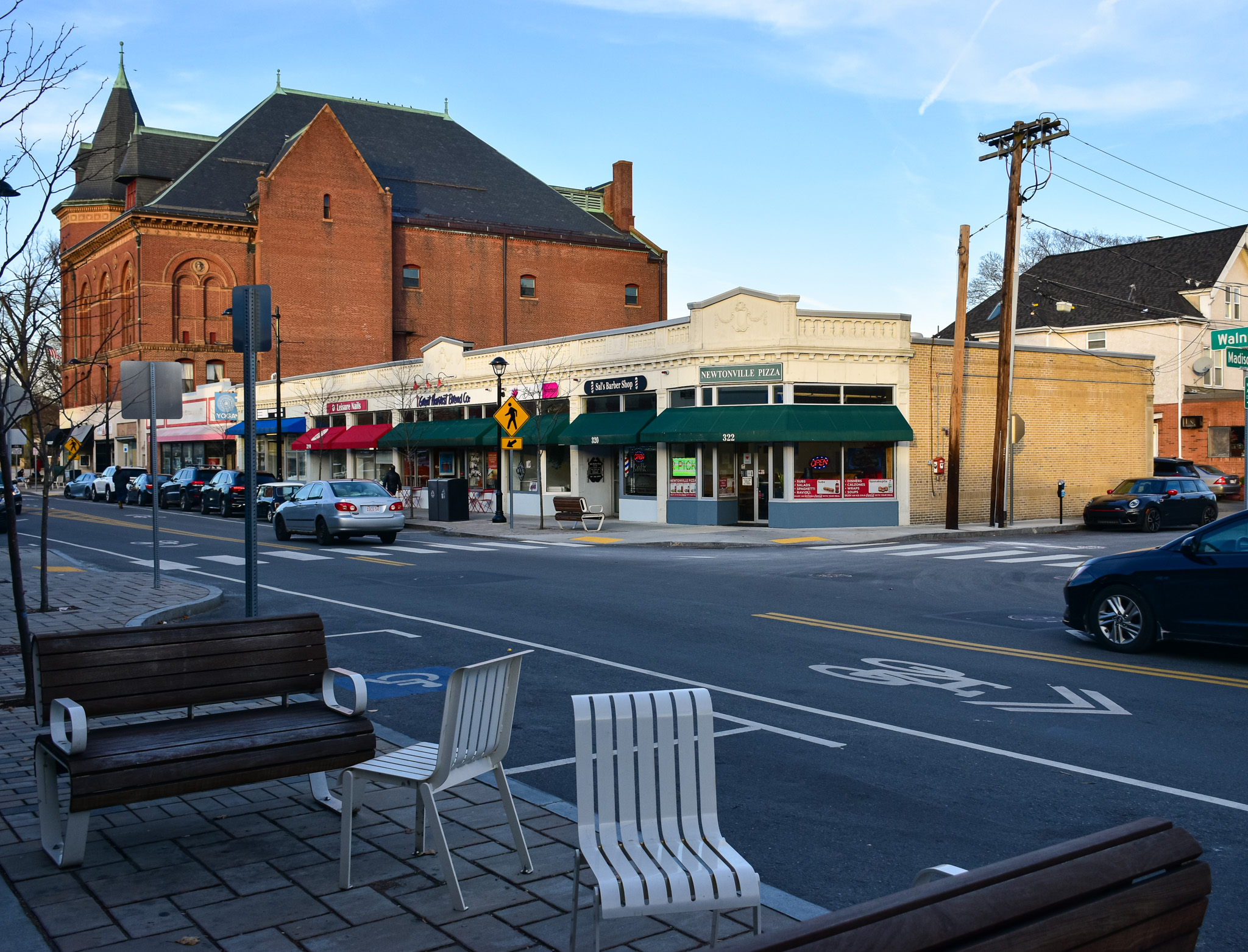
Between the Masonic Temple and Madison Avenue on the east side of the street are located three relatively drab one-story retail buildings. They all date to sometime in the 1920s. I know at some point, the first Newtonville Star Market was located along here. Currently these buildings are occupied by Newtonville Pizza, Sal's Barber Shop, Blossom Nutrition, Great Harvest Bakery, Leisure Nails, YGK Kitchen Cabinets and an empty storefront where once stood a CVS. The pharmacy has since moved to space at Trio Newton. I have heard that a plan has been submitted to the city to build a few stories on top of the CVS for apartments and retail.

(Leisure Nails, Great Harvest, Blossom Nutrition.)

On Madison Avenue, near the corner of Walnut Street, is Phoenix Physical Therapy, which is located in a building that has had a revolving door of tenants over the years.

The building rose in 1925, according to the assessor's database.

Hey, how 'bout a flashback for longtime Newton residents!

Debbie's Petland was located at 330 Walnut Street, next to Village Bank, for many years (the ghost sign shown above is located on another building). By the time I moved to Newtonville, the store was Newtonville Pet. I used to go there for cat food, litter and toys. I also used to take my kids there when they were little, just to look at the fish, birds, snakes, puppies and kittens. That store, which was run by very friendly folks, closed in 2014 after 18 years in business. The space, which is owned by Village Bank, has been vacant ever since. I'm not sure why.

On the other side of Madison Avenue is a similar set of retail buildings, home to Mochiko Hawaiian, which sells fried chicken, bubble tea and other foods; Natural Sense cosmetics; Village Bank; Opticians 3; Title City Barbers; Aji, a Japanese retaurant; and Donut Villa.

(Village Bank, on the left, and Title City Barbers.)

(The former Brewers Coalition space is now occupied by Donut Villa. I really miss the Coalition.)

The west side of Walnut Street looks very much like its eastern twin, with low-slung retail buildings from the 1920s. Tenants on this side of the main drag include Los Amigos Taqueria, Rancatore's Ice Cream & Yogurt, Newtonville Laundromat, Nail It! salon, Brookline Bank, a UPS store, Union Pharmacy, LeDu Thai restaurant and George Howell Coffee.

The last two buildings on this block that I want to highlight are banks. The first one looks like a "bank," while the second one I find much more inviting.

303 Walnut Street "was designed in 1919 for the Newton Trust Co. by the Thomas James Co., a firm specializing in bank designs," according to MACRIS. I guess NTC picked the right firm, but I find this building quite imposing. I suppose that's what most folks want in a bank.

Its neighbor at #305, however makes me feel welcomed.

This bank "was designed in 1938 for the Newton Cooperative Bank by Quincy architect, C.F.N. Rogers," per MACRIS. "Its Neo-Federal style design complements the earlier, Classical Revival style bank next door." Complements the Bank of America building? More like, "makes it look like a less evil version of the Death Star."

I want to close out this post, this look at Newtonville and this entire series with a piece of art.

Painted by Destiny S. Palmer, this bold and beautiful mural graces Philip Bram Way, the plaza and walkway created next to the 28 Austin Street Apartments that rose on a former municipal parking lot in 2019. Once a driveway into said parking lot, Bram Way is a nice oasis in the middle of the bustling village. Folks can sit at tables and chairs sipping coffee or gnoshing on snacks or relaxing with their kids after shopping at Henry Bear's Park, a great toy store that's part of a local chain.

I'm hoping somebody can tell me who Philip Bram was.

As for the artist, Palmer works at Thayer Academy in Braintree. Prior to that, she was an Assistant Professor at Massachusetts College of Art and Design, according to her web site. "Palmer is trained as a painter but her work explores the intersections of painting, history and color, allowing it to blur the lines of painting, sculpture and installation. Palmer has participated in exhibitions at Antenna Gallery, The Colored Girls Museum, Automat Collective, Ely Center for the Arts, Vandermoot Gallery, Landmark College."

I have only hung out on the plaza on a few occasions, for short periods of time. But I know it's popular with high school kids and folks who live, work, shop and eat in the area. When 28 Austin Street was proposed, some Newton residents complained about the loss of a parking lot, the addition of kids to local schools and the possibility for increased traffic. I don't know what, if any, negative impacts this apartment building has had on Newtonville, but I know that it has positively affected the public gathering mojo in the village.

And I love the addition of the mural. One of my favorite trends in recent years of exploring towns and cities of Greater Boston is the explosion of public art across the sides of buildings, the entirety of electrical boxes and even vacant storefronts. These expressions help bring life and color and joy to places. With more development in the planning for Newtonville, West Newton and elsewhere in the Garden City, residents can expect to be wowed with more such artistic statements.

And so I draw the curtains on Newton. I hope you have enjoyed this series, and that you will continue to keep up with this blog and all the other fantastic places I explore. From the bottom of my heart....

Here are the previous posts in the series:

February 4, 2023, "I Seek Newton, Part XIII: Newtonville (Section 2)"

January 28, 2023, "I Seek Newton, Part XIII: Newtonville (Section 1, The Orr Block/Trio Newton)"

September 10, 2022, "I Seek Newton, Part XII: West Newton (Section 3)"

September 3, 2022, "I Seek Newton, Part XII: West Newton (Section 2)"

August 27, 2022, "I Seek Newton, Part XII: West Newton (Section 1: The Barn Redevelopment)"

December 31, 2021, "I Seek Newton, Part XI: Newton Corner (Section 3)"

December 18, 2021, "I Seek Newton, Part XI: Newton Corner (Section 2)"

December 11, 2021, "I Seek Newton, Part XI: Newton Corner (Section 1)"

April 10, 2021, "I Seek Newton, Part X: Newton Centre (Section 3)"

April 3, 2021, "I Seek Newton, Part X: Newton Centre (Section 2)"

March 27, 2021, "I Seek Newton, Part X: Newton Centre (Section 1)"

November 15, 2020, "I Seek Newton, Part IX: Nonantum (Section 3)"

October 29, 2020, "I Seek Newton, Part IX: Nonantum (Section 2)"

September 24, 2020, "I Seek Newton, Part IX: Nonantum (Section 1)"

March 14, 2018, "I Seek Newton, Part VIII: Upper Falls (Section 3)"

March 8, 2018, "I Seek Newton, Part VIII: Upper Falls (Section 2)"

March 1, 2018, "I Seek Newton, Part VIII: Upper Falls (Section 1)"

March 7, 2017, "I Seek Newton, Part VII: Thompsonville"

December 5, 2016, "I Seek Newton, Part VI: Chestnut Hill"

September 26, 2016, "I Seek Newton, Part V: Oak Hill"

June 3, 2016, "I Seek Newton, Part IV: Waban"

March 23, 2016, "I Seek Newton, Part III: Newton Highlands"

September 20, 2015, "I Seek Newton, Part II: Auburndale"

May 21, 2015, "I Seek Newton, Part I: Lower Falls"

Way Down Yonder in Pawtucket, Part I

From Dave Brigham: I apologize in advance for this, but I often feel the need to explain my headline choices: I'll admit that befo...