Showing posts with label suburbex. Show all posts

Saturday, April 19, 2025

UPDATE: No Farms. No Food. No Dice?

From Wile E. Coyote:

In February 2018, I wrote about a historic farm in a corner of Waltham, Mass., that had fallen fallow (see February 15, 2018, "No Farms. No Food. No Dice?"). At that time, the City of Waltham had entered into negotiations to acquire the farm, which had been continuously farmed from at least 1650 until 2011. Every so often after I published that post, I would drive by the site on Warren Street looking for signs of progress. All I saw was a gradual decline in the farmhouse.

Then, one day....

Information about the restoration and planned future use is scarce online. As far as I know, the city plans to use the acreage for a tree farm. I don't know whether there is a plan to try and save the garage on the property.

I've taken a lot of photos of this garage over the years, so I hope the city just leaves it to nature. But I doubt that will happen.

Saturday, March 29, 2025

Holy Moses! Look at These Old Tablets

From Dave Brigham:

Unlike Moses, I didn't need to ascend an Egyptian mountain to find amazing hand-carved tablets. Rather, my Mount Sinai moment came at the foot of a former trash heap in the leafy outskirts of Boston.

Somewhere, somehow (I really need to keep track of this stuff), I learned while minding my own business on the World Wide Internet about two large carved-stone blocks located along the Charles River in West Roxbury's Millennium Park. In a flash, I was gobbling up information at this blog post at And This Is Good Old Boston.

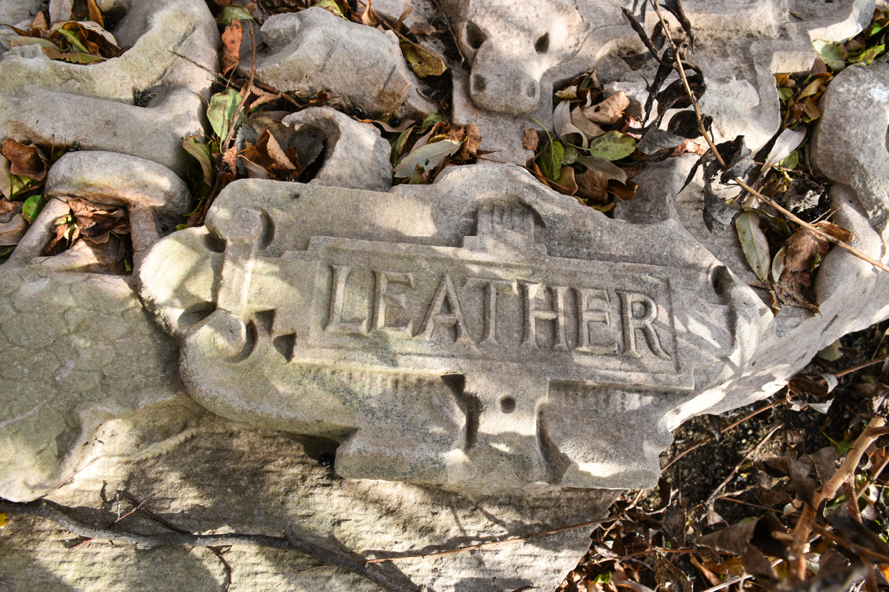
"The first is labeled 'Machinery' above the word are two machine gears, and to the sides are two classical figures swinging hammers," I read at the blog. "In the middle of the stone is a large shield, with a smaller American stars and stripes shield above it. On a ribbon running behind the American shield are the words E. Pluribus Unum....The second block is labeled Leather. Again, there is an elaborate shield in the center of the carving. This time, the smaller shield at the top represents the shield of the Commonwealth of Massachusetts."

Within relatively short order, I drove due south through several Newton villages and into West Roxbury. I parked in Millennium's kayak launch lot and followed the path at the western end, as instructed in the blog post. There were lots of families and couples walking dogs and generally enjoying a cool yet still warmer-than-normal autumn day.

I'd hiked a bit at the park a few times over the years, but I was still surprised at the steep angle of the former dump. At the top of the landfill cap are a handful of athletic fields, walking trails and a parking lot. But my quarry was located at the bottom of the hill, near the Charles River.

Sciatica pain be damned, I hobbled down the paved path, took a wrong turn, doubled back, and found a dirt path that seemed promising. I thought perhaps I was on the wrong trail, but when it turned left along the Charles River, I began to get a good feeling. And sure enough, about 30 feet past the lookout area where some folks had stopped to observe the river's drought-stricken water level, I found what I was looking for.

Despite knowing I would find them here, still I was fascinated (and dumbfounded) by these slabs. Measuring perhaps 5 feet by 3 feet, they are heavy and ostentatious and nearly otherworldly laying there just a few feet from where people hike every day. I sense your puzzlement. "What the hell are those things, and what are they doing there?"

"The seals were part of the 'First National Bank of Boston' façade," according to an anonymous commenter on the above-linked blog post. "I found some photos/ artist renderings along with a news article describing the building as having 5 of these carved 'plaques' in recognition of Bostons (sic) significant contribution to the textile industry."

While a subsequent commenter doubted whether that bank was the origin of the panels, further research by a Boston Globe reporter and the Boston City Archeologist confirmed that theory. "We pored over image archives and were able to find that the Boston Public Library had an image of the bank from 1910," the Globe article reports. "The tablets are just visible on the right side of the image, enough to confirm that the leftmost tablet is the 'Leather' tablet and the far right tablet is 'Machinery.'"

To see video of the tablets, check out this separate Globe article (I apologize if it's behind a paywall).

As I made photos, several people walked by. Since I was just a few feet off the trail, I assumed that to these folks, the discarded stone slabs were old news. I'm so happy I stumbled across mention of this bizarre treasure, because I never would have found myself walking along this part of the park, and if by some miracle I had, I likely wouldn't have noticed the large stone blocks.

While the detectives mentioned in this post were able to determine where the tablets came from, no one has definitively been able to say how they ended up in their current position. The First National Bank of Boston was demolished in 1944. "In the mid-20th century, the hill [now known as Millennium Park] was first used as a gravel quarry, resulting in a massive hole in its center," according to the Globe article featuring the city archeologist. "That hole became a convenient place to dump trash, so the city turned it into the Gardner Street Landfill, a municipal dump that was used into the 1980s. As the First National Bank was demolished during a time when the landfill was active, it’s likely that these and other fragments of the bank were dumped unceremoniously in West Roxbury."

These big chunks are pretty far from the old landfill site, located very close to the river. It's likely somebody dragged the stones there. But how long ago? And why?

For a post about another slab of stone sitting in a puzzling site, check out "I Seek Newton, Part III: Highlands", a March 23, 2016, post about the Newton Highlands neighborhood and Cold Spring Park.

Saturday, November 23, 2024

Jalopies in the Landlocked Forest

From Dave Brigham:

I really need to keep better track of where I get leads for this blog. At some point in the last several months, I read about a place called the Landlocked Forest in Burlington, Mass. I can tell you that I saw somebody's photos on Flickr featuring junked cars in the wooded expanse, and that's what convinced me to visit.

The conservation area is located on the border with neighboring Lexington. I parked in the small lot along Turning Mill Road, not far from an old paint mine I explored several years before (see September 2, 2014, "Make Mine Paint").

Along the power line trail leading to the forest, I met a distressed ursas arctos.

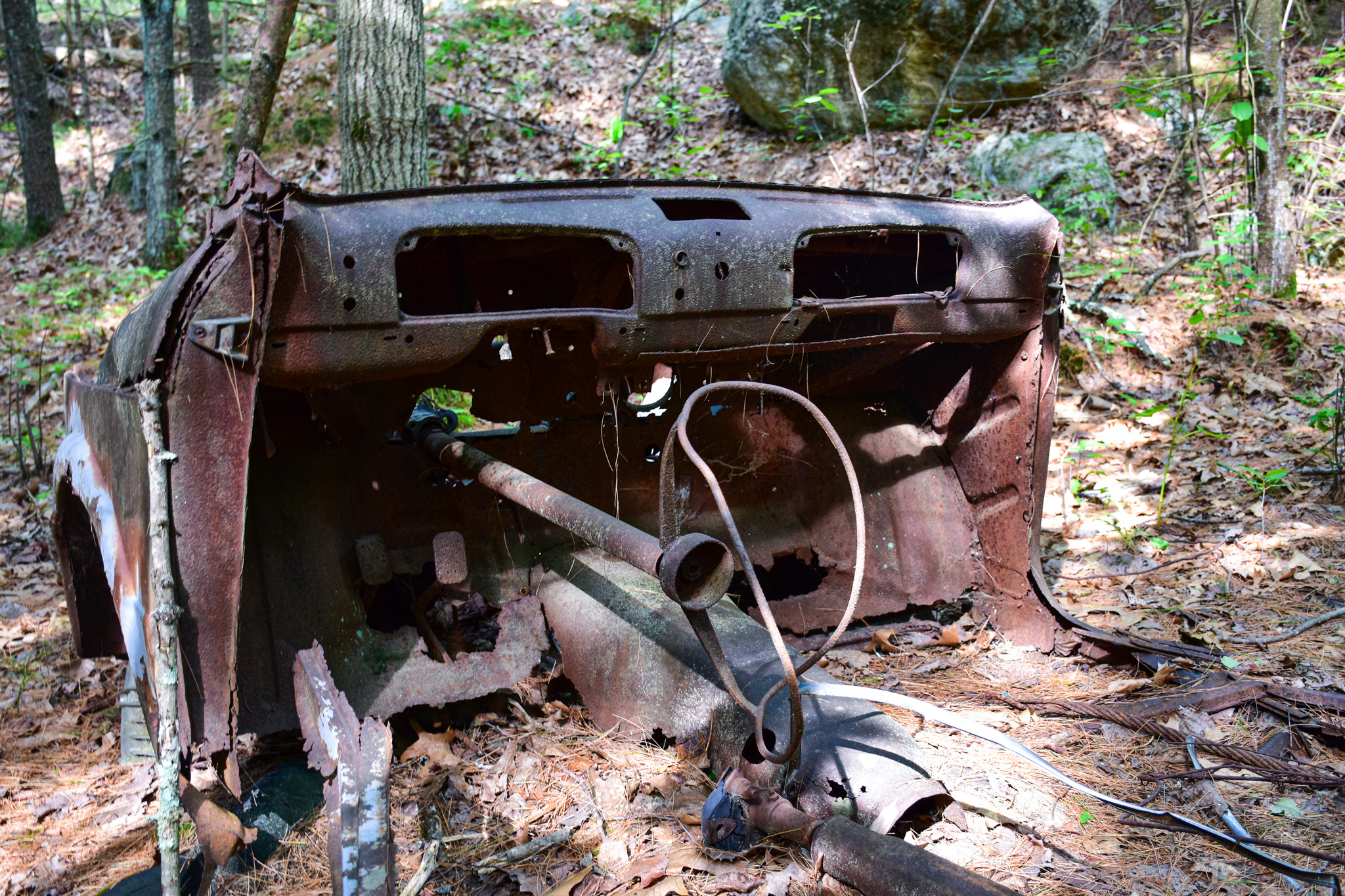
Once I got in the forest, I spent approximately 98% of my time and 87% of my energy swatting away bugs of all sorts - mosquitos, flies, gnats, you name it. I had a general idea of where the rusted-out jalopies were, so I followed my instincts as I headed north through the trees. After a while, I came across some extremely rusty something-or-others.

While the Friends of the Burlington Landlocked Forest indicates on its web site that there is within the woods a stone foundation from a home dating to the 1700s, I didn't see it. And I have no idea what the rusted metal in the photos above might have been. Part of an old shed, perhaps?

I kept chugging along, heading east until I was close to Route 3. I'd seen a mama deer, thanks to a heads-up from a passing mountain biker, but not much else of interest. I turned back to the west, swatting away bugs all the while, trying to make sense of Google Maps as I wandered. I got close to a residential development at one point, so had to head a little more south. I hit a few dead ends and was starting to get a little frustrated when -- AHA!!

I don't know what kind of car that is, nor can I identify either of the other two show below.

So why are there cars strewn across the wooded landscape in the middle of a lovely hiking and biking oasis?

Until the 1950s, at least some of the forested land was privately owned. There was, I assume, at least one road here, a throughway where at some point a few cars broke down or were stolen and abandoned. In the '50s, the state extended Route 3 south through Burlington and "owners of the property within the Landlocked Forest were compensated by the State because they were now unable to access their land," according to the Friends of the Burlington Landlocked Forest web site.

In the ensuing decades, the property owners petitioned the state legislature to permit access to the land from Route 3, but each time they were denied. In the late 1980s, the Town of Burlington took the property by eminent domain and created the conservation area.

I hope to return to the Landlocked Forest this fall or winter, when I can enjoy an insect-free walk.

To see more junked cars in the woods, check out the links below:

March 30, 2024, "Finding the Fascinating Ford's Folly"

August 30, 2016, "The Tavern of Death"

April 2, 2010, "Time Capsule Car"

Saturday, September 28, 2024

I Visited a Hospital and I Wasn't Even Sick

From Dave Brigham:

From the earliest days of this blog, I dreamt of exploring Medfield State Hospital. Scanning various urbex blogs I followed, I saw loads of photos of the former insane asylum, which overlooks the Charles River just north of Route 27 in Medfield, Mass. I assumed that in order to capture my own images, I would need to trespass, which isn't something I typically do.

So when I finally found the opportunity to check it out, I was expecting to make photos from behind fences of buildings that were falling apart after standing for more than 125 years. I was pleasantly surprised to find a rather bucolic site where I could roam freely alongside families and other photographers and couples on intimate strolls.

I've written before about former state mental hospitals located in Waltham, Mass. (see March 20, 2017, "Brigham in Waltham, Part III" and August 23, 2010, "You Don't Have to Be Crazy to Live Here, But It Helps"). I have not written about the infamous Fernald School, which is also located in Waltham. Whenever I would drive by the site, I spied security cars, and just kept going.

Medfield State Hospital was established in 1892 as the Medfield Insane Asylum, and was the first Massachusetts facility built specifically for long-term, high-need chronic patients, according to MACRIS. "The unique college-like campus is considered to be one of the finest works of [architect William Pitt] Wentworth's career," per MACRIS. "The campus was arranged in a quadrangle with an administration building and wards for 'quiet' patients at its head; wards for 'untidy, excited and epilectic (sic) patients' around its perimeter; infirmary and industrial buildings at its corner; and a chapel, laundry, kitchen/dining facility, powerhouse and carpenter's shop at its center."

I was completely charmed by the buildings, the campus, the poetry scattered across buildings, the quad where events take place, the beautiful church surrounded by flowers, and so much more. The Town of Medfield purchased 128 acres of the original 296-acre site in 2014. I will discuss this more below.

As time wore on, the campus grew in both population and number of buildings. Structures added to the original campus included a farm house for a farmer and 15-20 patients; an industrial building for making clothes, ironwork, upholstery and mattresses; a nurse's residence and school; a hospital for tubercular patients; wood-frame cottages for patients and employees alike; and a superintendent's house.

According to Wikipedia, "At its height the complex included 58 buildings, on a property of some 1.4 sq mi., and a capacity of 2,200 patients. It raised its own livestock and produce, and generated its own heat, light and power. Added to the National Register of Historic Places in 1994, the property was closed in April 2003 and the buildings shuttered."

(The most modern structure on the site is this water tower.)

There is a large and beautiful mural on the former mechanical building.

Painted by artist Cedric "Vise1" Douglas, the work of art features a girl playing a violin. Douglas said the work was inspired by the former hospital's history of including music as part of its therapy, according to this Wicked Local article.

The art also complements the mission of the Bellforge Arts Center, which presents live music, theater, dance, health and wellness programs and activities for children on the Medfield State campus. After the town purchased the property, there was a four-year period of "extensive public input," according to the arts center's web site. "[A] master plan was completed in 2018, and in 2020 the Bellforge Arts Center secured a 99-year lease with the town on two signature buildings at the core of the campus."

One of those buildings is the former hospital infirmary, which still needs to be renovated; the other, seen below, is the lovely chapel, which looks great but evidently needs work. Eventually, there will be a glass annex connecting the pair.

In addition to the arts and culture spaces, the town's long-term plan for the site is expected to result in 334 new apartments, 25% of which will be affordable, according to the town's web site. Additionally, the town plans to maintain open space on the property and preserve the historic buildings, "netting an estimated $700,000 annually in additional tax revenue for the town."

I'm so happy that my initial expectations about Medfield State Hospital were blown out of the water. Where I thought I'd find dilapidated buildings and barriers to entry, I instead was met with open access and joyful strollers (of course, I imagine that when I first became aware of this place all those years ago, it may very well have been more decrepit and blocked off). I look forward to following the progress as this site becomes a larger part of the Medfield community.

Way Down Yonder in Pawtucket, Part I

From Dave Brigham: I apologize in advance for this, but I often feel the need to explain my headline choices: I'll admit that befo...